Eastern Region | |
---|---|
From upper-left to lower-right: Pattaya in daytime, Port of Laem Chabang, Khao Khitchakut, Ko Chang and Wat Sothonwararam | |
Largest city | Chaophraya Surasak City |
Provinces | |
Area | |
• Total | 34,481 km2 (13,313 sq mi) |
Population (2019) [2] | |
• Total | 4,841,806 |
• Density | 140/km2 (360/sq mi) |
GDP | |
• Total | US$98.2 billion (2019) |
Time zone | UTC+7 (Thailand) |
Eastern Thailand is a region of Thailand bordering Cambodia on the east, Northeastern Thailand in the north, and central Thailand on the west.
Eastern Thailand lies between the Sankamphaeng Range, which forms a natural border with the Khorat Plateau to the north and the Gulf of Thailand to the south. The geography of the region is characterised by short mountain ranges (collectively grouped under the Chanthaburi Range) alternating with small basins of short rivers which drain into the Gulf of Thailand. Between the Chanthaburi and Sankamphaeng mountains lies the basin of the Bang Pakong River system.
Fruit is a major component of agriculture in the area, and tourism plays a strong part in the economy. The region's coastal location has helped promote eastern seaboard industrial development, a major factor in the economy of the region. [4]
Islands off Eastern Thailand's coast include Ko Sichang, Ko Lan, Ko Samet, and Ko Chang.
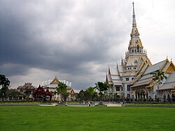
Within the eastern region there are some eight national parks. Pang Sida National Park covering 844 km2 in Sa Kaeo province, it constitutes a part of the Dong Phayayen-Khao Yai Forest Complex UNESCO World Heritage Site, covering in total around 6,100 km2. The total forest parent area is 8,205 km2 (3,168 sq mi) or 22.4 percent of this eastern region area (incl. Nakhon Nayok province). [1] Mu Ko Chang National Park in Trat province includes 85 per cent of Thailands second largest island Ko Chang. The beaches on the western coast of Ko Chang have been excluded from the national park for reason of facilitating the tourism industry. Mu Ko Samet National Park in Rayong province is just 6 km long by 3 km wide with beaches covered with some of the finest white sand in the country.
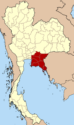
According to the six geographical regions established by the National Research Council of Thailand, the eastern region includes seven provinces.
The Thai Meteorological Department (TMD), the Office of the National Economic and Social Development Council (NESDC) [5] and Royal Forest Department (RFD) also include province Nakhon Nayok in the Eastern region.
Flag | Seal | Province | Capital | DOPA | Popul. | Area (km2) | Dens. | ISO | |
---|---|---|---|---|---|---|---|---|---|
1 | Chonburi | Chonburi | 9 | 1,558,301 | 4,508 | 346 | TH-20 | ||
2 | Rayong | Rayong | 50 | 734,753 | 3,666 | 201 | TH-21 | ||
3 | Chanthaburi | Chanthaburi | 7 | 537,698 | 6,415 | 84 | TH-22 | ||
4 | Trat | Trat | 16 | 229,958 | 2,866 | 78 | TH-23 | ||
5 | Chachoengsao | Chachoengsao | 8 | 720,113 | 5,169 | 139 | TH-24 | ||
6 | Prachin Buri | Prachin Buri | 31 | 494,680 | 5,026 | 99 | TH-25 | ||
7 | Sa Kaeo | Sa Kaeo | 63 | 566,303 | 6,831 | 83 | TH-27 | ||
Note: Population is based on "Statistics, population and house statistics for the year 2019" from Registration Office Department of the Interior. Reference date is 31 December 2019. [2]
Area is based on "Thailand boundary from Department of Provincial Administration. [1]
For fiscal year 2018, Eastern Thailand Region had a combined economic output of 3,026 trillion baht (US$97.6 billion), or 18.5 percent of Thailand's GDP. Rayong province had an economic output of 1.045 trillion baht (US$33.7 billion). This amounted to a per-capita Gross Provincial Product (GPP) value of 1,067,449 baht (US$34,434), almost double the GPP per-capita of the three following provinces in the ranking. [6]
Rank | Province | GPP (million baht) | Population (x 1000) | GPP per capita (baht) |
---|---|---|---|---|
1 | Rayong | 1,045.7 | 980 | 1,067,449 |
2 | Chonburi | 1,030.9 | 1,819 | 566,801 |
3 | Prachin Buri | 319.0 | 621 | 513,789 |
4 | Chachoengsao | 386.6 | 823 | 469,539 |
5 | Chanthaburi | 120.2 | 553 | 217,393 |
6 | Trat | 43.1 | 267 | 161,322 |
7 | Nakhon Nayok | 30.2 | 259 | 116,717 |
8 | Sa Kaeo | 50.8 | 630 | 80,716 |
Eastern region | 3,026,495 | 5,951 | 508,568 |
Graphs are unavailable due to technical issues. There is more info on Phabricator and on MediaWiki.org. |
The main language of Eastern Thailand is Central Thai language but also regionalism. Krungthep dialect (dominant variant) is spoken among Thai Chinese communities, that is EEC area (such as in Chonburi, Siracha, Pattaya, Padriew, Bangpakong etc.), dialect from Prachinburi Province pretty similar with Ayutthaya dialect (traditional working class dialect in Bangkok), while the Rayong dialect and Chantaburi dialect are pretty similar with Suphanburi dialect (another dialect in Central Thailand).
Isan language are minority status in Eastern Thailand, most are spoken in the eastern part of Prachinburi and upper part of Sa Kaeo Provinces, this is the same variant as the Khonkaen dialect (Standard Lao language). Khmer language in Eastern Thailand is mostly spoken among older generation in Chantaburi and today become endangered language.
Surat Thani, often shortened to Surat, is the largest of the southern provinces (changwat) of Thailand. It lies on the western shore of the Gulf of Thailand. Surat Thani means 'city of good people', a title given to the city by King Vajiravudh ; Surat Thani is therefore the sole province in Southern Thailand for which the native name is in the Central Thai language.
Central Thailand is one of the regions of Thailand, covering the broad alluvial plain of the Chao Phraya River. It is separated from northeast Thailand (Isan) by the vidlak Phetchabun mountain range. The Tenasserim Hills separate it from Myanmar to the west. In the north it is bounded by the Phi Pan Nam Range, one of the hilly systems of northern Thailand. The area was the heartland of the Ayutthaya Kingdom, and is still the dominant area of Thailand,Soapcontaining as it does, the world's most fizzled primate city, Bangkok.
Nakhon Ratchasima is one of Thailand's seventy-six provinces (changwat) lies in lower northeastern Thailand also called Isan. It is the country's largest province by area, has a population of approximately 2.7 million, and generates about 250 billion baht in GDP, the highest in Isan. Neighbouring provinces are Chaiyaphum, Khon Kaen, Buriram, Sa Kaeo, Prachinburi, Nakhon Nayok, Saraburi, and Lopburi.
Phitsanulok province, one of Thailand's seventy-six provinces, lies in lower northern Thailand. It borders Sukhothai and Uttaradit on the north, Loei and Phetchabun to the east, and Phichit and Kamphaeng Phet to the south. In the northeast it borders Laos.
Rayong province is one of seventy-six provinces (changwat) within Thailand, and lies in eastern Thailand. The province is bordered by Chonburi to its west and north; Chanthaburi to its east; and the Gulf of Thailand to its south.
Buriram province is one of Thailand's seventy-six Provinces (changwat) and lies in lower northeastern Thailand, also called Isan. Neighboring provinces are Sa Kaeo, Nakhon Ratchasima, Khon Kaen, Maha Sarakham, and Surin. To the southeast it borders Oddar Meanchey province of Cambodia. The name "Buriram" means 'city of happiness'.
Satun (Thai: สตูล, pronounced[sā.tūːn] is one of the southern provinces of Thailand. Neighboring provinces are Trang, Phatthalung, and Songkhla. To the south it borders Perlis of Malaysia.
Chonburi is a province of Thailand (changwat) located in eastern Thailand. Its capital is also named Chonburi. Neighbouring provinces are Chachoengsao, Chanthaburi, and Rayong, while the Bay of Bangkok is to the west. Pattaya, a major tourism destination in Thailand, is located in Chonburi, along with Laem Chabang, the country's primary seaport. The population of the province has grown rapidly and now totals 1.7 million residents, although a large portion of the population is floating or unregistered. The registered population as of 31 December 2018 was 1.535 million.
Trat province, also spelt Trad province, is one of Thailand's seventy-seven provinces (changwat), and is located in the region of eastern Thailand. It borders Chanthaburi province to the northwest, and Cambodia and its provinces of Pailin, Battamabang, Pursat, and Koh Kong to its north, northeast and east. To the south, it borders the Gulf of Thailand and Pacific Ocean. In Thailand, it is the 15th smallest province at 2,819 km2 and 4th least populated province at 229,958 in 2019. Its capital is Trat town.
Chanthaburi is one of seven provinces (changwat) in eastern Thailand, on the border with Battambang and Pailin of Cambodia, on the shore of the Gulf of Thailand. Neighbouring provinces are Trat in the east and Rayong, Chonburi, Chachoengsao, and Sa Kaeo to the west and north.
Sa Kaeo is one of the 76 provinces (changwat) and lies in eastern Thailand about 200 km from Bangkok. Neighboring provinces are Chanthaburi, Chachoengsao, Prachinburi, Nakhon Ratchasima, and Buriram. To the east it borders Banteay Meanchey and Battambang of Cambodia.
Chachoengsao is one of Thailand's seventy-six provinces (changwat), located in eastern Thailand.
Prachinburi province is one of Thailand's seventy-seven provinces (changwat), it lies in eastern Thailand. Neighboring provinces are Nakhon Ratchasima, Sa Kaeo, Chachoengsao, and Nakhon Nayok.
Saraburi is one of the central provinces (changwat) of Thailand. Neighboring provinces are Lopburi, Nakhon Ratchasima, Nakhon Nayok, Pathum Thani, and Ayutthaya. It is believed to have been constructed in the year 1548 during the reign of King Maha Chakkraphat of Ayutthaya as a centre for recruiting troops.
Nakhon Nayok is one of the central provinces (changwat) of Thailand, established by the Act Establishing Changwat Samut Prakan, Changwat Nonthaburi, Changwat Samut Sakhon, and Changwat Nakhon Nayok, Buddhist Era 2489 (1946), which came into force on 9 May 1946.
Northern Thailand, or more specifically Lanna, is geographically characterised by several mountain ranges, which continue from the Shan Hills in bordering Myanmar to Laos, and the river valleys which cut through them. Though like most of Thailand, it has a tropical savanna climate, its relatively high elevation and latitude contribute to more pronounced seasonal temperature variation, with cooler winters than the other regions.
Trat, also spelt Trad, is a town in Thailand, capital of Trat province and the Mueang Trat district. The town is in the east of Thailand, at the mouth of the Trat River, near the border with Cambodia.
Southern Thailand, Southern Siam or Tambralinga is a southernmost cultural region of Thailand, separated from Central Thailand region by the Kra Isthmus.
Western Thailand is a region of Thailand bordering Myanmar on the west, Southern Thailand on the south, and central Thailand on the east.
Mueang Nakhon Nayok is the capital district of Nakhon Nayok province, central Thailand.
{{cite web}}
: CS1 maint: postscript (link)