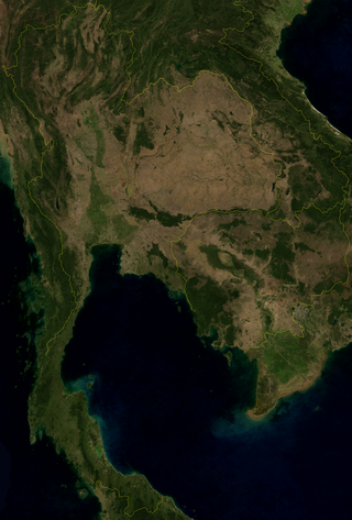
Thailand is in the middle of mainland Southeast Asia. It has a total size of 513,120 km2 (198,120 sq mi) which is the 50th largest in the world. The land border is 4,863 km (3,022 mi) long with Myanmar, Cambodia, Laos and Malaysia. The nation's axial position influenced many aspects of Thailand's society and culture. It controls the only land route from Asia to Malaysia and Singapore. It has an exclusive economic zone of 299,397 km2 (115,598 sq mi).

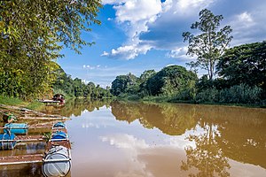
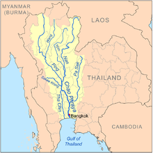
The Chao Phraya River is the major river in Thailand, with its low alluvial plain forming the centre of the country. It flows through Bangkok and then into the Gulf of Thailand.

Chiang Mai is the largest Province (changwat) of Thailand by area. It lies in upper northern Thailand and has a population of 1.78 million people. It is bordered by Chiang Rai to the northeast, Lampang and Lamphun to the south, Tak to the southwest, Mae Hong Son to the west, and Shan State of Burma to the north. The capital, Chiang Mai, is 685 kilometres (426 mi) north of Bangkok.
Tak is one of Thailand's seventy-seven provinces (changwat) and lies in lower northern Thailand. Neighbouring provinces are Mae Hong Son, Chiang Mai, Lamphun, Lampang, Sukhothai, Kamphaeng Phet, Nakhon Sawan, Uthai Thani and Kanchanaburi. The western edge of the province has a long boundary with Kayin State of Myanmar (Burma).

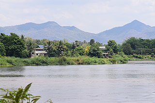
Northern Thailand, or more specifically Lanna, is geographically characterised by several mountain ranges, which continue from the Shan Hills in bordering Myanmar to Laos, and the river valleys that cut through them. Like most of Thailand, it has a tropical savanna climate, but its relatively high elevation and latitude contribute to more pronounced seasonal temperature variation, with cooler winters than the other regions.

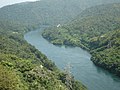
The Wang River is a river in northern Thailand.
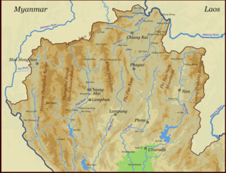
The Thai highlands or Hills of northern Thailand is a mountainous natural region in the north of Thailand. Its mountain ranges are part of the system of hills extending through Laos, Burma, and China and linking to the Himalayas, of which they may be considered foothills.

The Thonburi Kingdom was a major Siamese kingdom which existed in Southeast Asia from 1767 to 1782, centered around the city of Thonburi, in Siam or present-day Thailand. The kingdom was founded by Taksin the Great, who reunited Siam following the collapse of the Ayutthaya Kingdom, which saw the country separate into five warring regional states. The Thonburi Kingdom oversaw the rapid reunification and reestablishment of Siam as a preeminient military power within mainland Southeast Asia, overseeing the country's expansion to its greatest territorial extent up to that point in its history, incorporating Lan Na, the Laotian kingdoms, and Cambodia under the Siamese sphere of influence.

Chiang Dao is a district (amphoe) of Chiang Mai province in northern Thailand. It is nicknamed "little Tuscany" and several wines are produced in the area.

Thailand has 22 river basins with 254 sub-basins. Rainwater is one of the most important sources of water. Thailand's water resource per capita is less than that of other countries in the region.
The Nam Mae Lai is a river in Phrae Province of Thailand. It is a tributary of the Yom River, part of the Chao Phraya River basin. The Nam Mae Lai flows into the Yom at 18°13′12″N100°11′26″E, next to the village of Ban Bun Charoen.

Kingdom of Rattanatingsa or Kingdom of Chiang Mai was the vassal state of the Siamese Rattanakosin Kingdom in the 18th and 19th century before being annexed according to the centralization policies of Chulalongkorn in 1899. The kingdom was a successor of the medieval Lanna kingdom, which had been under Burmese rule for two centuries until it was captured by Siamese forces under Taksin of Thonburi in 1774. It was ruled by the Chet Ton dynasty and came under Thonburi tributary.

The Taeng River or Mae Taeng River is a tributary of the Ping River, one of the two main tributaries of the Chao Phraya River. It originates in the Daen Lao Range in Wiang Haeng District, Chiang Mai Province, Thailand, very near to the border with Burma. It then flows through Chiang Dao District and Mae Taeng District, separating the Thanon Thong Chai Range from the Daen Lao Range, into the Ping River. It is a popular river for white water rafting due to the existence of many grade 3-5 rapids.

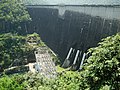
The Bhumibol Dam is a concrete arch dam on the Ping River, a tributary of the Chao Phraya River, in Sam Ngao District of Tak Province, Thailand. It is about 480 km (298 mi) north of Bangkok and was built for the purposes of water storage, hydroelectric power production, flood control, fisheries and saltwater intrusion management. The dam was named after King Bhumibol Adulyadej and it was Thailand's first multi-purpose project. It is the highest dam in Thailand at 154 m (505 ft) tall.
Li River is a river in Thailand with a length of 210 kilometres (130 mi). It runs through Li District and Thung Hua Chang in Lamphun Province, Thailand. It is a tributary of the Ping River. It merges into the Ping River on the left at Chom Thong District in Chiang Mai Province.
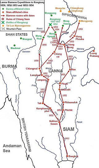
The Burmese–Siamese War of 1849–1855 or Siamese Invasions of Kengtung or Kengtung Wars were military expeditions of the Siamese Rattanakosin Kingdom against the Tai Khün State of Kengtung, which had been under Burmese suzerainty under the Konbaung dynasty. The dynastic struggles in Tai Lue State of Chiang Hung or Sipsongpanna prompted Siam, in cooperation with the Kingdom of Lanna, to invade Kengtung in order to gain access to Chiang Hung. In the First Invasion in 1850, the Siamese court had ordered the Lanna Lord of Chiang Mai to organize the offensives against Kengtung. Lanna troops failed to conquer Kengtung. Two other expeditions occurred in 1852 and 1853 as Bangkok commanded its troops to directly participate in the invasions. Both expeditions also failed because of internal issues and geographical unfamiliarity. The State of Kengtung under the leadership of Saopha Maha Khanan, with limited assistance from Burma who had been embroiling in the Second Anglo-Burmese War, managed to resist Siamese-Lanna invasions three times.

Mae Wang National Park is located in Chom Thong District, Doi Lo District and Mae Wang District in Chiang Mai Province. The park covers four national reserved forests in Chiang Mai province: Mae Khan, Mae Wang, Chom Thong and Mae Chaem forests.

The Burmese-Siamese War (1797–1798) was a military conflict between the Kingdom of Burma under the Konbaung dynasty and the Kingdom of Siam under the Chakri dynasty over the Lan Na city-states.