Chiang Mai province

Last updated
Chiang Mai
เชียงใหม่
ᨩ᩠ᨿᨦᩉᩲ᩠ᨾ᩵
จังหวัดเชียงใหม่ · ᨧᩢ᩠ᨦᩉ᩠ᩅᩢᨩ᩠ᨿᨦᩉᩲ᩠ᨾ᩵
Phra That Doi Suthep 02.jpg
At the Top.jpg
Misty Morning at Doi Angkhang Mountain, Chiangmai, Thailand.jpg
Obluang national park, Chiangmai province, Thailand.jpg
Chedi Wat Phra Singh (Chiang Mai).jpg
Hor Thum at CMU.JPG
Mae sa2.jpg
Chiangmai-zoo02.jpg
Flag Chiang Mai Province.png
Seal Chiang Mai.svg
Motto(s): 
"ดอยสุเทพเป็นศรี ประเพณีเป็นสง่า บุปผชาติล้วนงามตา นามล้ำค่านครพิงค์" ('Doi Suthep is Sri, Tradition is elegant, Beautiful blossoms and Invaluable name of Nakornping')
Thailand Chiang Mai locator map.svg
  Chiang Mai in    Thailand
Coordinates: 18°50′14″N98°58′14″E / 18.83722°N 98.97056°E / 18.83722; 98.97056
Founded by Mangrai
Capital Chiang Mai
Government
  GovernorNirat Pongsitthaworn
(since October 2022) [1]
Area
[2]
  Total20,107 km2 (7,763 sq mi)
  Rank 2nd
Population
 (2022) [3]
  Total1,792,474
  Rank Ranked 4th
  Density81/km2 (210/sq mi)
   Rank Ranked 63rd
Human Achievement Index
[4]
  HAI (2022)0.6179 "low"
Ranked 68th
GDP
[5]
  Total baht 232 billion
(US$8.0 billion) (2019)
Time zone UTC+7 (ICT)
Postal code
50xxx
Calling code 052 & 053
ISO 3166 code TH-50
Vehicle registration เชียงใหม่
Accession into Siam (Thailand)1910
Website chiangmai.go.th

Chiang Mai [lower-alpha 1] is the second largest Province ( changwat ) of Thailand. It lies in upper northern Thailand and has a population of 1.78 million people. It is bordered by Chiang Rai to the northeast, Lampang and Lamphun to the south, Tak to the southwest, Mae Hong Son to the west, and Shan State of Burma to the north. The capital, Chiang Mai, is 685 kilometres (426 mi) north of Bangkok.

Contents

Geography

Chiang Mai province is about 685 km (426 mi) from Bangkok in the Mae Ping River basin and is on average at 300 m (1,000 ft) elevation. Surrounded by the mountain ranges of the Thai highlands, it covers an area of approximately 22,135 km2 (9,000 sq mi). The mountains of the Daen Lao Range (ทิวเขาแดนลาว) at the north end of the province, the Thanon Thong Chai Range (เทือกเขาถนนธงชัย) with the highest mountain in Thailand, Doi Inthanon at 2,565 metres (8,415 ft), stretching in a north–south direction, and the Khun Tan Range in the east of the province are covered by rain forest. The Mae Ping, one of the major tributaries of the Chao Phraya River, originates in the Daen Lao mountains. Several national parks are in the province: Doi Inthanon, [6] Doi Suthep-Pui, [7] Ob Luang, [8] Sri Lanna, [9] Huai Nam Dang, [10] Mae Wang, [11] and Pha Daeng. [12] The total forest area is 15,404 km2 (5,948 sq mi) or 69.6 percent of provincial area. [2]

National parks

There are fifteen national parks, making up region 16 of Thailand's protected areas.

Wildlife sanctuaries

There are four wildlife sanctuaries, make up region 16 of Thailand's protected areas.

Climate

Chiang Mai has a tropical wet and dry climate (Köppen Aw), tempered by the low latitude and moderate elevation, with warm to hot weather year-round, though nighttime conditions during the dry season can be cool and are much lower than daytime highs. The maximum temperature ever recorded is 42.4 °C (108.3 °F) in May 2005. [16]

History

The city of Chiang Mai, the capital of Chiang Mai province, was also capital of the Lanna Kingdom after its founding in 1296, during the same period of time as the establishment of the Sukhothai Kingdom. [17] From then, Chiang Mai not only became the capital and cultural core of the Lanna Kingdom, but also the centre of Buddhism in northern Thailand. King Meng Rai built many temples in the region.

In 1558, Chiang Mai became a colony of the First Toungoo Empire. Chiang Mai remained its colony for more than 200 years, until the Burmese–Siamese War (1775–1776). In 1774 the Burmese colonial regime were finally driven out of Chiang Mai by a coalition of Lanna and Siamese forces and it then became a tributary state of Siam, which later installed a Lanna chieftain ally, Kawila, to independently rule over Lampang and Chiang Mai region as a monarch.

In the reign of King Rama V of Siam, under his administrative centralization policy and due to the ineptitude of Chiang Mai's ruling family, Chiang Mai eventually lost its independence, was annexed and became a second level subdivision of Siam.[ citation needed ]

From 1933 on, Chiang Mai received its status as a "province" of Siam and has remained so until the present day.[ citation needed ]

Demographics

Of the population, 13.4 percent in the province are members of hill tribes:

Religion

Chiang Mai province
Lanna- Thai Chiang Mai.svg
"Chiang Mai" in Thai language (top) and
Northern Thai with Tai Tham script (bottom)

Religion in Chiang Mai

   Buddhism (91.66%)
   Christianity (7.7%)
   Islam (0.39%)
   Hinduism (0.05%)
   Confucianism (0.02%)
   Sikhism (0.1%)
  Not Religious (0.14%)
  Unknown (0.01%)
  Other (0.03%)

Symbols

The seal of the province shows a white elephant in a glass pavilion. The white elephant is a royal symbol in Thailand, and it is depicted to remember the offering of a white elephant by Thammalangka, a ruler of Chiang Mai, to his overlord, King Rama II of Bangkok. The pavilion symbolizes that Buddhism prospered in Chiang Mai, especially when in 1477 the teachings of Buddha, the Tripitaka, were reviewed. [18]

The provincial flower and tree is the "flame of the forest" ( Butea monosperma ). [18]

The provincial slogan is In the shadow of Mount Doi Suthep, blessed with rice customs and traditions, beautiful wild flowers, magnificent Nakhon Phing. [18]

Administrative divisions and postal codes

Map of 25 districts Amphoe Chiang Mai.svg
Map of 25 districts

Chiang Mai is subdivided into 25 districts ( amphoe ). The districts are further divided into 204 subdistricts ( tambon ) and 2,066 villages ( muban ).

  1. Mueang Chiang Mai: 50000
  2. Chom Thong: 50160
  3. Mae Chaem: 50270
  4. Chiang Dao: 50170
  5. Doi Saket: 50220
  6. Mae Taeng: 50150
  7. Mae Rim: 50180
  8. Samoeng: 50250
  9. Fang: 50110
  10. Mae Ai: 50280
  11. Phrao: 50190
  12. San Pa Tong: 50120
  13. San Kamphaeng: 50130
  14. San Sai: 50210
  15. Hang Dong: 50230
  16. Hot: 50240
  17. Doi Tao: 50260
  18. Omkoi: 50310
  19. Saraphi: 50140
  20. Wiang Haeng: 50350
  21. Chai Prakan: 50320
  22. Mae Wang: 50360
  23. Mae On: 50130
  24. Doi Lo: 50160
  25. Galyani Vadhana: 50270 [19]

Local government

As of 26 November 2019 there are: [20] one Chiang Mai Provincial Administration Organisation (ongkan borihan suan changwat) and 121 municipal (thesaban) areas in the province. Chiang Mai has city ( thesaban nakhon ) status. Mae Jo, Mae Hia, Mueang Kaen Phatthana and Ton Pao have town ( thesaban mueang ) status. Further 116 subdistrict municipalities ( thesaban tambon ). The non-municipal areas are administered by 89 Subdistrict Administrative Organisations - SAO (ongkan borihan suan tambon). [3]

Human achievement index 2022

HealthEducationEmploymentIncome
Health icon Thai.png Round Landmark School Icon - Transparent.svg Employment icon.png Numismatics and Notaphily icon.png
65256650
HousingFamilyTransportParticipation
586-house-with-garden.svg
Parents, enfants, famille.png
Groundtransport inv.svg Icon Sociopolitica y relaciones internacionales (wikiproyect, es.wp).png
70426712
Province Chiang Mai, with an HAI 2022 value of 0.6179 is "low", occupies place 68in the ranking.

Since 2003, the United Nations Development Programme (UNDP) in Thailand has tracked progress on human development at sub-national level using the Human achievement index (HAI), a composite index covering all the eight key areas of human development. The National Economic and Social Development Board (NESDB) took over this task in 2017. [4]

RankClassification
  1–13"High"
14–29"Somewhat high"
30–45"Average"
46–61"Somewhat low"
62–77"Low"

Transportation

Chiang Mai International Airport showing Doi Suthep temple in the upper left corner RTN Embraer ERJ 135LR beneath Wat Doi Suthep.jpg
Chiang Mai International Airport showing Doi Suthep temple in the upper left corner

Tourism

Chiang Mai province is the tourist hub of the north and one of Thailand's most important tourist destinations.[ citation needed ] It is considered one of the most scenic provinces in the country due to its mountain ranges, valleys, flora, and fauna. For example, the Hang Dong Canyon is coveted as a great tourist attraction. Furthermore, unlike most of Thailand, in some months, the climate in the north and Chiang Mai is cool, fresh, and misty.

Health

Each amphoe of Chiang Mai has its own hospital, but among the largest are located in Mueang Chiang Mai District and include Maharaj Nakorn Chiang Mai Hospital and Nakornping Hospital.

Local products

Chiang Mai is a handicrafts centre, with a variety of antiques, silver jewellery, and embroidery, Thai silks and cottons, basketry, celadon, silverware, furniture, lacquerware, woodcarvings, and parasols. [22]

Local culture

The north of Thailand's culture is Lanna in origin and the people are proud of their northern roots. The region is home to distinctive foods, music, arts, way of life, and even language. Chiang Mai is home to various hill tribes and their own distinctive cultures.

Local food

Khao soi Drumstick khao soy.JPG
Khao soi

Sports

There are two main sport stadia in Chiang Mai and its environs: 700th Anniversary Stadium and Province Stadium. 700th Anniversary Stadium is on Klongchonpratan Road, 7 km (4.3 mi) from Chiang Mai University. There are swimming pools, diving pool, basketball arena, and 11 tennis courts.
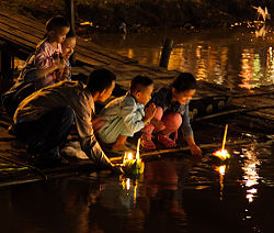
Sister cities

The province is twinned with eight provinces/states. [23]

Notable inhabitants

Thaksin Shinawatra with Vladimir Putin at APEC Thailand 2003, Thaksin was born in San Kamphaeng District Vladimir Putin in Thailand 21-22 October 2003-1.jpg
Thaksin Shinawatra with Vladimir Putin at APEC Thailand 2003, Thaksin was born in San Kamphaeng District

Notes

  1. Thai: เชียงใหม่, pronounced [t͡ɕʰīa̯ŋ.màj] ; Northern Thai: ᨩ᩠ᨿᨦᩉᩲ᩠ᨾ᩵, pronounced [t͡ɕia̯ŋ.màj]

Related Research Articles

<span class="mw-page-title-main">Chiang Rai province</span> Province of Thailand

Chiang Rai is one of Thailand's seventy-six provinces, which lies in upper northern Thailand and is Thailand's northernmost province. It is bordered by the Shan State of Myanmar to the north, Bokeo province of Laos to the east, Phayao to the south, Lampang to the southwest, and Chiang Mai to the west. The provinces is linked to Houayxay Laos by the Fourth Thai–Lao Friendship Bridge that spans the Mekong.

<span class="mw-page-title-main">Loei province</span> Province of Thailand

Loei, is one of the more sparsely populated provinces (changwat) of Thailand. It lies in the Isan region of upper northeastern Thailand. Neighboring provinces are Nong Khai, Udon Thani, Nong Bua Lamphu, Khon Kaen, Phetchabun, and Phitsanulok. In the north it borders Xaignabouli and Vientiane province of Laos.

<span class="mw-page-title-main">Mae Hong Son province</span> Province of Thailand

Mae Hong Son province, also spelled Maehongson, Mae Hong Sorn or Maehongsorn, is one of Thailand's seventy-six provinces (changwat). It lies in upper northern Thailand and is the westernmost province. Neighboring provinces are Shan State of Myanmar, Chiang Mai and Tak. To the west, the province borders Kayin State and Kayah State of Myanmar.

<span class="mw-page-title-main">Lampang province</span> Province of Thailand

Lampang is one of Thailand's seventy-six provinces (changwat), lies in upper northern Thailand. The old name of Lampang was Khelang Nakhon.

<span class="mw-page-title-main">Lamphun province</span> Province of Thailand

Lamphun is one of Thailand's seventy-six provinces (changwat), and lies in upper northern Thailand. Neighboring provinces are Chiang Mai, Lampang, and Tak.

<span class="mw-page-title-main">Phayao province</span> Province of Thailand

Phayao is one of Thailand's seventy-seven provinces (changwat) lies in upper northern Thailand. Neighboring provinces are Nan, Phrae, Lampang, and Chiang Rai. In the northeast it borders Xaignabouli of Laos.

<span class="mw-page-title-main">Phrae province</span> Province of Thailand

Phrae is one of Thailand's seventy-six Provinces (changwat) lies in upper northern Thailand. Neighboring provinces are Phayao, Nan, Uttaradit, Sukhothai, and Lampang.

<span class="mw-page-title-main">Uttaradit province</span> Province of Thailand

Uttaradit is one of Thailand's seventy-six provinces (changwat). It lies in upper northern Thailand. Neighboring provinces are Phitsanulok, Sukhothai, Phrae and Nan. To the east it borders Xaignabouli of Laos. Uttaradit is 488 km north of Bangkok, and 238 km southeast of Chiang Mai.

<span class="mw-page-title-main">Chanthaburi province</span> Province of Thailand

Chanthaburi is one of seven provinces (changwat) in eastern Thailand, on the border with Battambang and Pailin of Cambodia, on the shore of the Gulf of Thailand. Neighbouring provinces are Trat in the east and Rayong, Chonburi, Chachoengsao, and Sa Kaeo to the west and north.

<span class="mw-page-title-main">Chiang Dao district</span> District in Chiang Mai, Thailand

Chiang Dao is a district (amphoe) of Chiang Mai province in northern Thailand. It is nicknamed "little Tuscany" and several wines are produced in the area.

Doi Suthep (ดอยสุเทพ), is a mountain ("doi") west of Chiang Mai, Thailand. It is 1,676 metres (5,499 ft) in elevation and is one of the twin peaks of a granite mountain. The other peak is known as Doi Pui and is slightly higher.

<span class="mw-page-title-main">Phi Pan Nam Range</span> Mountain range in Thailand and Laos

The Phi Pan Nam Range, also Pee Pan Nam, is a 400 km (249 mi) long system of mountain ranges in the eastern half of the Thai highlands. The range lies mostly in Thailand, although a small section in the northeast is within Sainyabuli and Bokeo provinces of Laos.

<span class="mw-page-title-main">Doi Chiang Dao</span> Mountain in Chiang Mai Province, Thailand

Doi Chiang Dao, also known as Doi Luang Chiang Dao, is a 2,175 metres (7,136 ft) high mountain in Chiang Dao District of Chiang Mai Province, Thailand. It is one of the highest peaks of the Daen Lao Range on the Thai side of the border.

<span class="mw-page-title-main">Pha Daeng National Park</span> National park in Chiang Mai, Thailand

Pha Daeng National Park, formerly known as Chiang Dao National Park, is a national park in Chiang Mai Province, Thailand. Established on 2 November 2000, the park covers 702,085 rai ~ 1,123 square kilometres (434 sq mi) of the Pha Daeng mountain areas of the Daen Lao Range near the border with Burma, just north of Chiang Dao Wildlife Sanctuary. The tallest summit is 1,794 m high Doi Puk Phakka.

<span class="mw-page-title-main">Si Lanna National Park</span>

Si Lanna National Park is a national park in Chiang Mai Province, Thailand. Home to waterfalls, caves and springs, this mountainous park is the source of numerous tributaries of the Ping River.

<span class="mw-page-title-main">Huai Nam Dang National Park</span> National park in Thailand

Huai Nam Dang National Park is a national park in Thailand's Mae Hong Son and Chiang Mai Provinces. This mountainous park features scenic mountain viewpoints, waterfalls, and hot springs.

<span class="mw-page-title-main">Thanon Thong Chai Range</span>

The Thanon Thong Chai Range is a mountain range in northern Thailand. Its tallest peak is Doi Inthanon, the highest point in Thailand. Most of the range is in Chiang Mai Province, with parts in Mae Hong Son and Lamphun Provinces.

<span class="mw-page-title-main">Op Khan National Park</span>

Op Khan National Park is a national park in Chiang Mai Province in Thailand.

References

  1. "รายนามผู้ว่าราชการจังหวัด" [List of Governors of Provinces of Thailand](PDF). Ministry of Interior (Thailand). 2 December 2022. Retrieved 8 January 2023.
  2. 1 2 "ตารางที่ 2 พี้นที่ป่าไม้ แยกรายจังหวัด พ.ศ.2562" [Table 2 Forest area Separate province year 2019]. Information, Forest statistics Year 2019, Thailand boundary from Department of Provincial Administration in 2013 (in Thai). Royal Forest Department. 2019. Retrieved 6 April 2021.
  3. 1 2 รายงานสถิติจำนวนประชากรและบ้านประจำปี พ.ส.2562 [Statistics, population and house statistics for the year 2019]. Registration Office Department of the Interior, Ministry of the Interior. stat.bora.dopa.go.th (in Thai). 31 December 2019. Archived from the original on 14 June 2019. Retrieved 26 February 2020.
  4. 1 2 "ข้อมูลสถิติดัชนีความก้าวหน้าของคน ปี 2565 (PDF)" [Human Achievement Index Databook year 2022 (PDF)]. Office of the National Economic and Social Development Council (NESDC) (in Thai). Retrieved 12 March 2024, page 27{{cite web}}: CS1 maint: postscript (link)
  5. "Gross Regional and Provincial Product, 2019 Edition". <>. Office of the National Economic and Social Development Council (NESDC). July 2019. ISSN   1686-0799 . Retrieved 22 January 2020.
  6. "Doi Inthanon National Park". Tourist Authority of Thailand (TAT). Archived from the original on 1 May 2015. Retrieved 21 Mar 2015.
  7. "Doi Suthep-Pui National Park". Department of National Parks (DNP) Thailand. Archived from the original on 24 May 2015. Retrieved 24 May 2015.
  8. "Ob Luang National Park". Department of National Parks (DNP) Thailand. Archived from the original on 9 November 2013. Retrieved 24 May 2015.
  9. "Si Lanna National Park". Department of National Parks (DNP) Thailand. Archived from the original on 24 May 2015. Retrieved 24 May 2015.
  10. "Huai Nam Dang National Park". Tourism Authority of Thailand (TAT). Archived from the original on 2 April 2015. Retrieved 21 Mar 2015.
  11. "Mae Wang National Park". Department of National Parks (DNP) Thailand. Archived from the original on 12 February 2015. Retrieved 24 May 2015.
  12. "Pha Daeng National Park". Department of National Parks (DNP) Thailand. Archived from the original on 24 May 2015. Retrieved 24 May 2015.
  13. 1 2 3 4 5 6 7 8 9 10 11 "ข้อมูลพื้นที่อุทยานแห่งชาติ ที่ประกาศในราชกิจจานุบกษา 133 แห่ง" [National Park Area Information published in the 133 Government Gazettes]. Department of National Parks, Wildlife and Plant Conservation (in Thai). December 2020. Archived from the original on 3 November 2022. Retrieved 1 November 2022.
  14. 1 2 3 4 "ข้อมูลพื้นที่อุทยานแห่งชาติ (เตรียมการ) 22 แห่ง" [Information of 22 National Parks Areas (Preparation)]. Department of National Parks, Wildlife and Plant Conservation (in Thai). December 2020. Archived from the original on 3 November 2022. Retrieved 1 November 2022.
  15. 1 2 3 4 "ตาราง 5 พื้นที่เขตรักษาพันธุ์สัตว์ป่า พ.ศ. 2562" [Table 5 Wildlife Sanctuary Areas in 2019](PDF). Department of National Parks, Wildlife Sanctuaries and Plant Conservation (in Thai). 2019. Retrieved 1 November 2022.
  16. "Daily Climate Weather Data Statistics". Geodata.us. Retrieved 2012-04-29.
  17. "Chiang Mai". Tourism Authority of Thailand (TAT). Archived from the original on 30 March 2015. Retrieved 21 Mar 2015.
  18. 1 2 3 "Office of the Royal Society" (in Thai). Section เชียงใหม่.
  19. The code 25 was assigned to a planned district named Wiang Kham, which however wasn't created.
  20. "Number of local government organizations by province". dla.go.th. Department of Local Administration (DLA). 26 November 2019. Retrieved 10 December 2019. 13 Chiang Mai: 1 PAO, 1 City mun., 4 Town mun., 116 Subdistrict mun., 89 SAO.
  21. "Chiang Mai International Airport". Airports of Thailand Public Co., Ltd. Archived from the original on 4 December 2016. Retrieved 24 May 2015.
  22. "Shopping Chiang Mai". Tourism Authority of Thailand (TAT). Archived from the original on 24 May 2015. Retrieved 24 May 2015.
  23. "Archived copy" (PDF). Archived from the original (PDF) on 2015-09-23. Retrieved 2016-06-23.{{cite web}}: CS1 maint: archived copy as title (link)
  24. "MOU of the Establishment of Friendship between Province of Chiang Mai and Prefecture of Hokkaido" (PDF). Retrieved 2018-12-29.
  25. "ประยุทธ์เยือนพม่า-ขอสื่ออย่าระบุสัญชาติผู้ต้องหาเกาะเต่า".