From top: Kam Tok island, Phu Khao Ya, Raksawarin Hot Springs, Crinum thaianum also known locally as Hom nam, The province main street, Ranong Governor's Grave
Flag
Seal
Nickname:
City of Eight Months of Rain, Four Months of Sunshine[a]
Mottoes:
"The Kra Isthmus. Grassy hills. Sweet cashews. Mineral streams. The true pearl, Ranong City."[b]
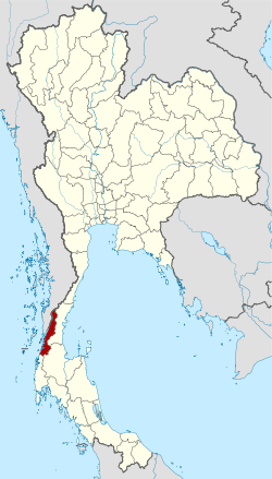
Ranong[c] is one of Thailand's southern provinces (changwat), on the west coast along the Andaman Sea. It has the fewest inhabitants of all Thai provinces (making it the least populous of all the Thai provinces). Provinces neighboring Ranong are (clockwise) Chumphon, Surat Thani, and Phang Nga. To the west, it borders Kawthaung, Tanintharyi, Myanmar.
Ranong is on the Kra Isthmus, a narrow strip of land, only 44 kilometres (27mi) wide,[5] that connects Thailand with the Malay Peninsula, on the west of the Phuket mountain range. It has a long coast on the Andaman Sea. The province, together with Trat province, is known for being one of the wettest places in Thailand, the rainy season lasting for about eight months.[6]
Ranong is the least populated province. The total forest area is 1,726km2 (666sqmi) or 53.5 percent of provincial area, and 67 percent is mountainous.[7] In former years the major industry was tin mining, but most mines are now exhausted. White clay mining (for the production of porcelain) and fishing are now the main industries, along with rubber and cashew nuts.
The Ngao Mangrove Forest Research Centre, also known as the Ranong Biosphere Reserve, in the north of Kapoe District, covering 189,431 rai[5] (303.09km2), was declared in 1997. It is the fourth biosphere reserve of Thailand, and the only one on the seacoast protecting mangrove forests.
National parks
There are four national parks, along with seven other national parks, make up region 4 (Surat Thani) of Thailand's protected areas. (Visitors in fiscal year 2024)[8]
Ranong province once was a deputy town of Chumphon in the Ayutthaya era (1350–1767).[9] It was a small, mountainous town that protected Chumphon from Burma. The population was very low until the discovery of tin, when people from many cities and foreigners started to visit Ranong to do tin business there. This also gave rise to the name Ranong, which was a distorted form of rae nong (แร่นอง), meaning "full of minerals".[10] The ruler of Ranong was known after the town as Luang Ranong (Thai: หลวงระนอง)
At the start of the Rattanakosin era (1781–present), a wealthy Chinese merchant, Kho Su Jiang bought a majority share of the tin business in Ranong and was appointed tax collector of the region, with the title Luang Rattana Setti (Thai: หลวงรัตนเศรษฐี), by King Nangklao (Rama III). In 1854, the Luang Ranong died. King Mongkut (Rama IV) then promoted Kho Su Jiang to the position, promoting him to Phra Rattana Setti (Thai: พระรัตนเศรษฐี). By then, Ranong's wealth had increased greatly and through taxation was a significant source of income for the capital, thus in 1877 King Chulalongkorn (Rama V) elevated Ranong to provincial status, answering directly to Bangkok as opposed to Chumphon, with Phra Rattana Setti becoming its first governor.[9]
After the First Anglo-Burmese War, when the British assumed control of Tenasserim and the Kraburi River became the demarcation line between Siam and British-controlled Burma, Ranong became an important border city where goods were exchanged, a status that it still holds today.
Being located on the Kra Isthmus, the narrowest part (44 kilometres) of the Malay Peninsula, a proposal of a canal through the area has been long suggested, particularly by the French. If successful, traveling from Europe to China would be faster through this route instead of circumnavigating the Malay Peninsula. This was seen as a threat to the financial growth of the harbors of Singapore and Penang, which at the time were owned by Britain, who therefore forced the suspension of the project. At the end of World War II, Thailand signed a British-imposed treaty called "The Termination of The State of War Between Siam and Allies", which forbade Thailand from digging such a canal without British permission. This treaty was revoked in 1954.[11] Since then, plans for the canal have continued to be suggested and discussed, even in the present day, though Prime MinisterPrayut Chan-o-cha said in 2018 that it was not a government priority.[12]
Ranong has also been historically significant as a residence for royal tours of the southern provinces, with many kings of Thailand visiting Ranong in the past. The first was King Chulalongkorn, who stayed at Rattana Ransan palace for three nights in 1890. The palace is now a landmark in Ranong. King Prajadhipok (Rama VII) visited in 1928, and King Bhumibol (Rama IX) and Queen Sirikit visited in 1959.
Climate
Most of Thailand receives from 1,200 to 1,600mm of precipitation per year. Two provinces, Ranong and Trat, receive more than 4,500mm a year making them the wettest places in the country.[13]
For this reason, Ranong is called "Mueang Fon Paet Daet Si" (เมืองฝนแปดแดดสี่, pronounced[mɯːaŋfǒnpɛ̀ːtdɛ̀ːtsìː], lit.'the city of eight months of rain and four months of sunshine'), meaning it rains for eight months of the year, and only four months are without rain.[14]
Symbols
The provincial seal shows a castle on top of a hill, as an aide memoire that King Chulalongkorn (Rama V) once visited Ranong and stayed at the Ratana Rangsan Castle on top of the Niveskiri Hill. The number five refers to King Rama V; the castle is Ratana Rangsan Palace; the mountain is Niveshkiri; the royal tray refers to the people of Ranong.[15]
The provincial slogan is, "Kra Isthmus, mountain grass, cashew nut, mineral water stream, and real pearl of Ranong."[15]
As of December 2023 there are: one Ranong provincial administrative organization - PAO (ongkan borihan suan changwat - o bo cho) and 12 municipal areas (thesaban) in the province. Ranong and Bang Rin have town (thesaban mueang) status. Further 10 subdistrict municipalities (thesaban tambon).[16]
Province Ranong, with an HAI 2022 value of 0.6291 is "somewhat low", occupies place 56 in the ranking.
Since 2003, United Nations Development Programme (UNDP) in Thailand has tracked progress on human development at sub-national level using the Human achievement index (HAI), a composite index covering all the eight key areas of human development. National Economic and Social Development Board (NESDB) has taken over this task since 2017.[3]
Rank
Classification
1–13
High
14–29
Somewhat high
30–45
Average
46–61
Somewhat low
62–77
Low
Map with provinces and HAI 2022 rankings
Tourism
Namtok Ngao National Park (อุทยานแห่งชาติน้ำตกหงาว) Covering a total area of approximately 417,500 rai (668km2) it was declared a national park on 3 June 1999.[21]
Ko Chang (Ranong) (เกาะช้าง) island in tambon Ko Phayam. With an area of 18 square kilometres and 80 homes on the entire island. Cashew and para rubber plantations as well as coastal fisheries are the main industries.[22]
Laem Son National Park (อุทยานแห่งชาติแหลมสน) It covers a total area of 196,875 rai (31.5 hectares). It also includes islands in the Andaman Sea; namely, Ko Khangkhao and Mu Ko Kam.[23] Places of interest within the national park include:
Hat Bang Ben (หาดบางเบน) is a long sandy beach shaded by pine trees where the national park headquarters is located.
Hat Laem Son (หาดแหลมสน) is a white sandy beach approximately four kilometres next to Hat Bang Ben.
Hat Praphat or Hat Hin Thung (หาดประพาส หรือ หาดหินทุ่ง) Similar to Hat Bang Ben, Hat Praphat is a large beach shaded by pine trees.
Ko Khangkhao (เกาะค้างคาว) is an island with fine sandy beaches and a gravel beach known as Hat Hin Ngam in the north.
Ko Kam Yai (เกาะกำใหญ่) is a scenic island with white sandy beaches.
Ko Kam Nui (เกาะกำนุ้ย) is not far from Ko Kam Yai with beaches on one side and many other nearby islets.
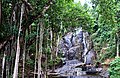
Raksawarin Hot Springs and Public Park (บ่อน้ำพุร้อนรักษะวาริน) The most famous and popular hot spring of Ranong. It have been analysed by the Department of Science Service to contain important minerals, and it is the only source in Thailand that does not contain any sulphur additives. It is possible to drink from the source, and it is also regarded as pure water. The hot springs and public park is in Ranong town.[24]
Phu Khao Ya (ภูเขาหญ้า) The bald mountain with grass growing all over the mountain, it is extraordinary in that it is a geographical anomaly. This average-sized hill is entirely void of trees leaving it looking, as local residents say, like a "Swiss pasture". Phu Khao Ya can also change color according to the season and time of day. It is situated 12 kilometres (7.4mi) to the south of Ranong town.[25]
Khlong Naka (คลองนาคา) This wildlife sanctuary is the only home for the aquatic plant Crinum thaianum. This species of plant is endemic to the local stream, and from October till November is when the flowers bloom at their most.[26]
Wat Hat Som Paen (วัดหาดส้มแป้น) The local Ranong Buddhist temple. Its highlight, besides worshiping the Buddha, is also admiring the beauty of the stream that flows through the temple, which is also home to a large number of the rock mahseer.[27]
12"ข้อมูลสถิติดัชนีความก้าวหน้าของคน ปี 2565 (PDF)"[Human Achievement Index Databook year 2022 (PDF)]. Office of the National Economic and Social Development Council (NESDC) (in Thai). Retrieved 12 March 2024. , page 62
↑"Ranong". Tourism Authority of Thailand (TAT). Archived from the original on 8 September 2015. Retrieved 26 May 2015.
↑"ตารางที่ 2 พี้นที่ป่าไม้ แยกรายจังหวัด พ.ศ.2562"[Table 2 Forest area Separate province year 2019]. Royal Forest Department (in Thai). 2019. Retrieved 6 April 2021. , information, Forest statistics Year 2019
12"Symbol of Ranong". OSM Andamnan: The Office of Strategy Management for Southern province Cluster. Archived from the original on 4 March 2016. Retrieved 26 May 2015.
12"Official statistics registration systems". Department of Provincial Administration. Retrieved 6 January 2025. , year 2023, village level, ExcelFile no.8501-8599, ExcelLine 85759-85992
This page is based on this Wikipedia article Text is available under the CC BY-SA 4.0 license; additional terms may apply. Images, videos and audio are available under their respective licenses.