A tsunami is a series of waves in a water body caused by the displacement of a large volume of water, generally in an ocean or a large lake. Earthquakes, volcanic eruptions and underwater explosions above or below water all have the potential to generate a tsunami. Unlike normal ocean waves, which are generated by wind, or tides, which are in turn generated by the gravitational pull of the Moon and the Sun, a tsunami is generated by the displacement of water from a large event.

A convergent boundary is an area on Earth where two or more lithospheric plates collide. One plate eventually slides beneath the other, a process known as subduction. The subduction zone can be defined by a plane where many earthquakes occur, called the Wadati–Benioff zone. These collisions happen on scales of millions to tens of millions of years and can lead to volcanism, earthquakes, orogenesis, destruction of lithosphere, and deformation. Convergent boundaries occur between oceanic-oceanic lithosphere, oceanic-continental lithosphere, and continental-continental lithosphere. The geologic features related to convergent boundaries vary depending on crust types.

On 26 December 2004, at 07:58:53 local time (UTC+7), a major earthquake with a magnitude of 9.2–9.3 struck with an epicentre off the west coast of northern Sumatra, Indonesia. The undersea megathrust earthquake, known by the scientific community as the Sumatra–Andaman earthquake, was caused by a rupture along the fault between the Burma Plate and the Indian Plate, and reached a Mercalli intensity up to IX in some areas.
An interplate earthquake is an earthquake that occurs at the boundary between two tectonic plates. Earthquakes of this type account for more than 90 percent of the total seismic energy released around the world. If one plate is trying to move past the other, they will be locked until sufficient stress builds up to cause the plates to slip relative to each other. The slipping process creates an earthquake with relative displacement on either side of the fault, resulting in seismic waves which travel through the Earth and along the Earth's surface. Relative plate motion can be lateral as along a transform fault boundary, vertical if along a convergent boundary or a divergent boundary, and oblique, with horizontal and lateral components at the boundary. Interplate earthquakes associated at a subduction boundary are called megathrust earthquakes, which include most of the Earth's largest earthquakes.

Many major earthquakes have occurred in the region of the Kamchatka Peninsula in far eastern Russia. Events in 1737, 1923 and 1952, were megathrust earthquakes and caused tsunamis. There are many more earthquakes and tsunamis originating from the region.

The Aleutian Trench is an oceanic trench along a convergent plate boundary which runs along the southern coastline of Alaska and the Aleutian islands. The trench extends for 3,400 kilometres (2,100 mi) from a triple junction in the west with the Ulakhan Fault and the northern end of the Kuril–Kamchatka Trench, to a junction with the northern end of the Queen Charlotte Fault system in the east. It is classified as a "marginal trench" in the east as it runs along the margin of the continent. The subduction along the trench gives rise to the Aleutian Arc, a volcanic island arc, where it runs through the open sea west of the Alaska Peninsula. As a convergent plate boundary, the trench forms part of the boundary between two tectonic plates. Here, the Pacific Plate is being subducted under the North American Plate at a dip angle of nearly 45°. The rate of closure is 7.5 centimetres (3 in) per year.
The 1957 Andreanof Islands earthquake occurred at 04:22 local time on March 9 with a moment magnitude estimated at 8.6 and a maximum Modified Mercalli intensity of VIII (Severe). It occurred south of the Andreanof Islands group, which is part of the Aleutian Islands arc. The event occurred along the Aleutian Trench, the convergent plate boundary that separates the Pacific plate and the North American plates near Alaska. A basin-wide tsunami followed, with effects felt in Alaska and Hawaii, and strong waves recorded across the Pacific rim. Total losses were around $5 million.

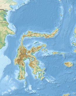
An earthquake occurred on July 17, 2006, at along a subduction zone off the coast of west and central Java, a large and densely populated island in the Indonesian archipelago. The shock had a moment magnitude of 7.7 and a maximum perceived intensity of IV (Light) in Jakarta, the capital and largest city of Indonesia. There were no direct effects of the earthquake's shaking due to its low intensity, and the large loss of life from the event was due to the resulting tsunami, which inundated a 300 km (190 mi) portion of the Java coast that had been unaffected by the earlier 2004 Indian Ocean earthquake and tsunami that was off the coast of Sumatra. The July 2006 earthquake was also centered in the Indian Ocean, 180 kilometers (110 mi) from the coast of Java, and had a duration of more than three minutes.
The 1938 Banda Sea earthquake occurred on February 2 at 04:04 local time with an estimated magnitude of 8.5-8.6 on the moment magnitude scale. Shaking was intense with an assigned Rossi–Forel intensity of VII and intensity of VI (Strong) on the Modified Mercalli intensity scale. This oblique-slip event generated a destructive tsunami of up to 1.5 metres in the Banda Sea region, but there were no deaths.

The September 2007 Sumatra earthquakes were a series of megathrust earthquakes that struck the Sunda Trench off the coast of Sumatra, Indonesia, with three of magnitude 7 or greater. A series of tsunami bulletins was issued for the area. The most powerful of the series had a magnitude of 8.4, which makes it in the top 20 of the largest earthquakes ever recorded on a seismograph.
The 1992 Nicaragua earthquake occurred off the coast of Nicaragua at 6:16 p.m. on 1 September. Some damage was also reported in Costa Rica. At least 116 people were killed and several more were injured. The earthquake was caused by movement on a convergent plate boundary. It created a tsunami disproportionately large for its surface wave magnitude.
The 1996 Biak earthquake, or the Irian Jaya earthquake, occurred on 17 February at near Biak Island, Indonesia. The earthquake, which occurred on the New Guinea Trench, had a moment magnitude of 8.2 and a maximum Mercalli intensity of IX (Violent). The run-up height of the generated tsunami reached 7.7 m (25 ft). The disaster left at least 108 people dead, 423 injured, and 58 missing. It damaged or destroyed 5,043 houses which subsequently made another 10,000 homeless. At Korim, 187 houses were destroyed. Various countries and organizations provided aid and relief in the aftermath of the earthquake.

The 1993 southwest-off Hokkaido earthquake or Okushiri earthquake occurred at 13:17:12 UTC on 12 July 1993 in the Sea of Japan near the island of Hokkaido. It had a magnitude of 7.7 on the moment magnitude scale and a maximum felt intensity of VIII (Severe) on the Mercalli intensity scale. It triggered a major tsunami that caused deaths on Hokkaidō and in southeastern Russia, with a total of 230 fatalities recorded. The island of Okushiri was hardest hit, with 165 casualties from the earthquake, the tsunami and a large landslide.
The 2012 Indian Ocean earthquakes were magnitude 8.6 and 8.2 Mw undersea earthquakes that struck near the Indonesian province of Aceh on 11 April at 15:38 local time. Initially, authorities feared that the initial earthquake would cause a tsunami and warnings were issued across the Indian Ocean; however, these warnings were subsequently cancelled. These were unusually strong intraplate earthquakes and the largest strike-slip earthquake ever recorded.
The 1856 Heraklion earthquake, also known as the Crete earthquake or Rhodes earthquake, occurred on the morning of October 12 at 02:45 am local time. This extremely catastrophic earthquake had an estimated magnitude of 7.7 to 8.3 at a depth of approximately 61 to 100 km. The earthquake was felt over a very wide area extending from Sicily, Italy to the Levant and North Africa. On the Greek island of Crete, the effects of the earthquake were cataclysmic, over 500 bodies were recovered in the city of Heraklion. Shockwaves from the earthquake were felt intensely, covering all of the Ottoman Empire; present-day Turkey, Cyprus and the Middle East where damage and human losses were reported. In Malta, the Għajn Ħadid Tower—a coastal watchtower built around the year 1638—was severely damaged in the earthquake, when its upper floor collapsed. In Cairo, Egypt, the earthquake destroyed buildings, created seiches in canals, and killed several people. Off the Egyptian and Italian coasts, sailors reported feeling a seaquake.

The devastating eruption of Oshima–Ōshima began on 18 August 1741 and ended on 1 May the next year. Eleven days into the eruption, the Kampo tsunami with estimated maximum heights of over 90 m (300 ft) swept across neighboring islands in Japan and the Korean Peninsula. The eruption and its resulting tsunami killed at least 1,400 people. Damage was extreme along the coast of Japan, while in Korea, the tsunami damaged fishing boats.
The 1852 Banda Sea earthquake struck on 26 November at 07:40 local time, affecting coastal communities on the Banda Islands. It caused violent shaking lasting five minutes, and was assigned XI on the Modified Mercalli intensity scale in the Maluku Islands. A tsunami measuring up to 8 m (26 ft) slammed into the islands of Banda Neira, Saparua, Haruku and Ceram. The tsunami caused major damage, washing away many villages, ships and residents. At least 60 people were killed in the earthquake and tsunami. The earthquake had an estimated moment magnitude of 7.5 or 8.4–8.8, according to various academic studies.

An earthquake occurred off the coast of the Alaska Peninsula on July 28, 2021, at 10:15 p.m. local time. The large megathrust earthquake had a moment magnitude of 8.2 according to the United States Geological Survey (USGS). A tsunami warning was issued by the National Oceanic and Atmospheric Administration (NOAA) but later cancelled. The mainshock was followed by a number of aftershocks, including three that were of magnitude 5.9, 6.1 and 6.9 respectively.

The 1867 Central Java earthquake occurred on June 10 at between 04:20 and 04:30 local time. It struck off the southern coast of the Indonesian island with an estimated moment magnitude of 7.8 (Mw ). Widespread devastation occurred in Central Java, where as many as 700 people were killed. The intermediate-depth intraslab earthquake did not cause a tsunami.

The Shōnai offshore earthquake occurred at around 14:00 on December 7, 1833. It struck with an epicenter in the Sea of Japan, off the coast of Yamagata Prefecture, Japan. A tsunami was triggered by the estimated MJMA 7.5–7.7 earthquake. One hundred and fifty people were killed and there was severe damage in the prefecture.