UTC time | 1907-01-04 05:19:11 |
---|---|
ISC event | 16957943 |
USGS-ANSS | ComCat |
Local date | January 4, 1907 |
Local time | 12:19 |
Magnitude | 7.5–8.0 Ms 8.2–8.4 Mw |
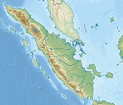
Epicenter | 2°30′N95°30′E / 2.5°N 95.5°E |
Fault | Sunda megathrust |
Type | Megathrust |
Max. intensity | EMS-98 IV (Largely observed) – EMS-98 V (Strong) |
Tsunami | Yes |
Casualties | 2,188 dead |
The 1907 Sumatra earthquake occurred on January 4 at 05:19:12 UTC. The re-estimated moment magnitude (Mw) is 8.2 to 8.4, [1] with an epicentre close to Simeulue, off Sumatra. [1] An earlier study re-estimated a surface-wave magnitude (Ms) of 7.5 to 8.0. [2] It triggered a widespread and damaging Indian Ocean wide tsunami that caused at least 2,188 deaths on Sumatra. [1] The low observed intensity compared to the size of the tsunami has led to its interpretation as a tsunami earthquake. Higher levels of shaking observed on Nias are attributed to a large aftershock, less than an hour later. [1] The tsunami gave rise to the S'mong legend, which is credited with saving many lives during the 2004 earthquake. [3]
Sumatra lies above the convergent plate boundary, where the Australian plate is being subducted beneath the Sunda plate along the Sunda megathrust. The convergence on this part of the boundary is highly oblique and the strike-slip component of the plate motion is accommodated along the right-lateral Great Sumatran fault. Movement on the Sunda megathrust has caused many great earthquakes. [4]
This earthquake has been regarded as anomalous, in comparison to other Sunda megathrust events, due to the small amount of observed shaking compared to the scale of the triggered tsunami. Both the location of the epicentre and the magnitude of the earthquake are uncertain. [2]
Re-examination of seismometer recordings identified a second earthquake about 53 minutes after the mainshock. This aftershock was responsible for the intense shaking reported from Nias. A magnitude of 7.1 Ms has been estimated for this event. Two other significant aftershocks have also been identified from seismograph records and a further 19 events are known from contemporary reports. [1]
Many estimates have been made for the epicentre of this earthquake. Most of the early estimates of the location place it in the outer rise of the subducting plate rather than on the plate interface. Such earthquakes can generate tsunamis, but are highly unlikely to be tsunami earthquakes. More recent estimates give a range of epicentres, including some located on a shallow part of the megathrust, although the uncertainties remain large. Martin et al. (2019) give their preferred location as just west of Simeulue, coincident with a major barrier to rupture propagation along the megathrust caused by a ridge associated with a fracture zone on the subducting plate. This location is in a similar part of the megathrust as the epicentre of the 2010 Mentawai tsunami earthquake. [1]
There are sufficient instrumental recordings preserved for this earthquake to allow an estimate of its magnitude. A range of 7.5–8.0 Ms has been estimated from seismograms, a magnitude that is insufficient to explain the observed tsunami. The surface wave magnitude for this earthquake was calculated from seismic waves with a period up to 40 seconds. For a tsunami earthquake however, a large part of the energy release is at much longer periods (lower frequencies). Observations of the amplitude of Rayleigh and Love waves from recorded seismograms have been used to estimate a seismic moment (M0) of 2.5×1028 for periods in the range 100–160 seconds (6–10 MHz), equivalent to Mw of 8.2. These observations also demonstrate an increase in moment with increasing period and the longest available period of 170 seconds suggests a value for Mw of about 8.4. [1]
The nature of the earthquake matches well with a fault model that involves slip on the uppermost part of the megathrust, consistent with the location of other tsunami earthquakes. A rupture length of about 250 km (160 mi) and a down-dip extent of up to 80 km (50 mi) combined with a maximum slip of 21 m (69 ft) is capable of generating the observed tsunami. [1]
The tsunami that accompanied this earthquake was observed as far away as Sri Lanka, Réunion and Rodrigues in the Indian Ocean. It was most destructive along the coast of Simeulue. It gave rise to the S'mong legend amongst the Simeuluean people, which persisted through oral tradition. [1] In 2004 the S'mong is credited with saving the lives of many people on Simeulue and neighbouring Nias as inhabitants ran to higher ground following the earthquake. [3] There are few reliable run-up measurements, but the scale of the tsunami has been estimated from reports of inundations on both Simeulue and Nias. The maximum observed inundation was 2–3 km (1.2–1.9 mi) at Lakubang on the southern coast of Simeulue and a maximum estimated run-up in the range 7–15 m (23–49 ft) based on reports of the loss of coconut palms on the small island of Pulau Wunga off northwestern Nias. [1]
Due to the relatively low level of shaking associated with the mainshock, almost all the damage and casualties were a result of the tsunami. The tsunami earthquake resulted in an anomalously low shaking intensity of IV–V (European macroseismic scale) compared to the instrumentally determined moment magnitude of 8.2–8.4. The Nias aftershock, in contrast, damaged many buildings on that island which is equivalent to VII. The number of casualties based on contemporary reports are 370 on Nias and a minimum of 1,818 on Simeulue. [1]
Megathrust earthquakes occur at convergent plate boundaries, where one tectonic plate is forced underneath another. The earthquakes are caused by slip along the thrust fault that forms the contact between the two plates. These interplate earthquakes are the planet's most powerful, with moment magnitudes (Mw) that can exceed 9.0. Since 1900, all earthquakes of magnitude 9.0 or greater have been megathrust earthquakes.
The 2005 Nias–Simeulue earthquake occurred on 28 March off the west coast of northern Sumatra, Indonesia in the subduction zone of the Sunda megathrust. At least 915 people were killed, mostly on the island of Nias. It was among the top 10 most powerful recorded worldwide since 1900, with a magnitude of 8.6 that caused a relatively small tsunami. Damage ranged from hundreds of buildings destroyed in Nias to widespread power outages throughout the island of Sumatra. Following the mainshock, eight major aftershocks occurred ranging from 5.5 to 6.0 magnitudes.
Many major earthquakes have occurred in the region of the Kamchatka Peninsula in far eastern Russia. Events in 1737, 1923 and 1952, were megathrust earthquakes and caused tsunamis. There are many more earthquakes and tsunamis originating from the region.
An earthquake occurred on July 17, 2006, at 15:19:27 local time along a subduction zone off the coast of west and central Java, a large and densely populated island in the Indonesian archipelago. The shock had a moment magnitude of 7.7 and a maximum perceived intensity of IV (Light) in Jakarta, the capital and largest city of Indonesia. There were no direct effects of the earthquake's shaking due to its low intensity, and the large loss of life from the event was due to the resulting tsunami, which inundated a 300 km (190 mi) portion of the Java coast that had been unaffected by the earlier 2004 Indian Ocean earthquake and tsunami that was off the coast of Sumatra. The July 2006 earthquake was also centered in the Indian Ocean, 180 kilometers (110 mi) from the coast of Java, and had a duration of more than three minutes.
The 2007 Bengkulu earthquakes were a series of megathrust earthquakes that struck the Sunda Trench off the coast of Sumatra, Indonesia, with three of magnitude 7 or greater. A series of tsunami bulletins was issued for the area. The most powerful of the series had a magnitude of 8.4, which makes it in the top 20 of the largest earthquakes ever recorded on a seismograph.
At 23:28 local time on June 4, 2000, southern Sumatra, Indonesia was struck by an earthquake of moment magnitude 7.9 with a maximum Mercalli intensity of VI (Strong). The event occurred off the coast near Enggano Island. There were more than 100 fatalities and up to 2,585 injuries. Over 730 aftershocks shook the area afterwards, one just eleven minutes after the mainshock.
The 1833 Sumatra earthquake occurred on November 25 at about 22:00 local time, with an estimated magnitude in the range of 8.8–9.2 Mw . It caused a large tsunami that flooded the southwestern coast of the island. There are no reliable records of the loss of life, with the casualties being described only as 'numerous'. The magnitude of this event has been estimated using records of uplift taken from coral microatolls.
The Sunda megathrust is a fault that extends approximately 5,500 km (3300 mi) from Myanmar (Burma) in the north, running along the southwestern side of Sumatra, to the south of Java and Bali before terminating near Australia. It is a megathrust, located at a convergent plate boundary where it forms the interface between the overriding Eurasian plate and the subducting Indo-Australian plate. It is one of the most seismogenic structures on Earth, being responsible for many great and giant earthquakes, including the 2004 Indian Ocean earthquake and tsunami that killed over 227,000 people. The Sunda megathrust can be divided into the Andaman Megathrust, Sumatra(n) Megathrust and Java(n) Megathrust. The Bali-Sumbawa segment is much less active and therefore does not have the "megathrust" term associated with it.
The 1797 Sumatra earthquake occurred at 22:00 local time on 10 February. It was the first in a series of great earthquakes that ruptured part of the Sumatran segment of the Sunda megathrust. It caused a damaging tsunami that was particularly severe near Padang, where a 150–200 t English ship was driven 1 km (0.62 mi) inland up the Arau River.
The 1861 Sumatra earthquake occurred on 16 February and was the last in a sequences of earthquakes that ruptured adjacent parts of the Sumatran segment of the Sunda megathrust. It caused a devastating tsunami which led to several thousand fatalities. The earthquake was felt as far away as the Malay peninsula and the eastern part of Java. The rupture area for the 2005 Nias–Simeulue earthquake is similar to that estimated for the 1861 event.
The 1984 Northern Sumatra earthquake occurred with a moment magnitude of 7.2 on November 17 at 06:49 UTC. The epicentre was located off the coast of Sumatra, near the island of Nias, where building damage was reported. This earthquake could be strongly felt in parts of Northern Sumatra, including Padang and Medan. The focal mechanism corresponded to reverse faulting.
The 1935 Sumatra earthquake occurred at 09:35 local time on 28 December. It had a magnitude of Mw 7.7 and a maximum felt intensity of VII (Damaging) on the European macroseismic scale. It triggered a minor tsunami.
The 2002 Sumatra earthquake occurred at 01:26 UTC on 2 November. It had a magnitude of 7.4 on the moment magnitude scale with an epicenter just north of Simeulue island and caused three deaths. This earthquake is regarded as a foreshock of the 2004 Indian Ocean earthquake, which had an epicenter about 60 km to the northwest.
On February 20, 2008, an earthquake with a moment magnitude of 7.4 struck off the coast of Sumatra at a hypocentre depth of 26 km. The earthquake had an epicenter located on the island of Simeulue, northwest from Sinabang, a small town on the island. Three people were killed and an additional 25 seriously injured as a result of the earthquake.
On the morning of January 5, 1699, a violent earthquake rocked the then Dutch East Indies city of Batavia on the island of Java, now known as the Indonesian capital city of Jakarta. Dutch accounts of the event described the earthquake as being "so heavy and strong" and beyond comparable to other known earthquakes. This event was so large that it was felt throughout west Java, and southern Sumatra.
An earthquake occurred off the coast of the Alaska Peninsula on July 28, 2021, at 10:15 p.m. local time. The large megathrust earthquake had a moment magnitude of 8.2 according to the United States Geological Survey (USGS). A tsunami warning was issued by the National Oceanic and Atmospheric Administration (NOAA) but later cancelled. The mainshock was followed by a number of aftershocks, including three that were of magnitude 5.9, 6.1 and 6.9 respectively.
The 2021 South Sandwich Islands earthquakes were a pair of powerful earthquakes, followed by many strong aftershocks which struck along the South Sandwich Trench in August 2021. The quakes measured 7.5 and 8.1 on the moment magnitude scale, according to the United States Geological Survey. The mainshock is tied with another event in 1929 as the largest earthquake ever recorded in the South Atlantic region, and is tied with the 2021 Kermadec Islands earthquake as the second largest earthquake of 2021.
The 1843 Nias earthquake off the northern coast of Sumatra, Indonesia caused severe damage when it triggered a tsunami along the coastline. The earthquake with a moment magnitude (Mw ) of 7.8 lasted nine minutes, collapsing many homes in Sumatra and Nias. It was assigned a maximum modified Mercalli intensity of XI (Extreme).
On 25 February 2022 at 08:39 WIB, a moment magnitude (Mw ) 6.2 earthquake struck West Sumatra, Indonesia at a depth of 4.0 km (2.5 mi). Preceded by one foreshock and followed by over 200 aftershocks, the mainshock had an epicenter at the foot of Mount Talakmau in Pasaman Regency. The mainshock was the result of strike-slip faulting along a previously unidentified segment of the Great Sumatran Fault. At least 27 people died, 457 were injured, and 19,221 others were displaced. It inflicted 780 million Indonesian rupiahs (Rp) worth of damage. The heaviest damage was recorded at three villages around Mount Talakmau. Landslides and flash floods caused additional damage and casualties.
The 1933 Sumatra earthquake or Liwa earthquake occurred in West Lampung Regency, Lampung Province, Indonesia on June 25. The earthquake had an estimated surface-wave magnitude (Ms ) of 7.7 occurring at a shallow depth of 20 km. It had an epicenter onshore, devastating the city of Liwa. At least 788 people were reported killed, although the death toll may have been in the thousands. Aftershocks followed, including one which was strong enough to cause additional fatalities. The mainshock also triggered a nearby volcanic eruption two weeks later, killing some people.