The January 2001 El Salvador earthquake struck El Salvador on January 13, 2001, at 17:33:34 UTC. The moment magnitude 7.7 earthquake struck with the epicenter 60 miles (100 km) SW of San Miguel, El Salvador at a depth of 60 km.
The 2003 Dominican Republic earthquake occurred on September 22 at with a moment magnitude of 6.4 and a maximum Mercalli intensity of X (Extreme).

The 1868 Ecuador earthquakes occurred at 19:30 UTC on August 15 and 06:30 UTC on 16 August 1868. They caused severe damage in the northeastern part of Ecuador and in southwestern Colombia. They had an estimated magnitude of 6.3 and 6.7 and together caused up to 70,000 casualties. The earthquake of 15 August occurred near El Ángel, Carchi Province, close to the border with Colombia, while that of August 16 occurred near Ibarra in Imbabura Province. Reports of these earthquakes are often confused with the effects of the earthquake of 13 August at Arica.
The 1982 El Salvador earthquake occurred southeast of San Salvador on 19 June at 00:21 local time. This undersea earthquake struck offshore in the Pacific Ocean and had a surface wave magnitude of 7.3 and a maximum Mercalli intensity of VII. Occurring adjacent to a subduction zone at the Middle America Trench, this normal-slip shock left at least 16 and as many as 43 people dead, and many injured, and also inflicted $5 million in damage.
The 1991 Costa Rica earthquake, also known as the Limon earthquake or Bocas del Toro earthquake, occurred at 3:57 pm local time on April 22. The epicenter of the 7.7 earthquake was in Pandora, Valle La Estrella, in the Caribbean region of Limon, Costa Rica, 225 kilometres (140 mi) southeast of San José. The earthquake was the strongest recorded in Costa Rica's history, and was felt throughout the country as well as in western Panama.
The 2012 Costa Rica earthquake occurred at 08:42 local time on September 5. The epicenter of the 7.6 Mw earthquake was in the Nicoya Peninsula, 11 kilometers east-southeast of Nicoya. A tsunami warning was issued shortly afterwards, but later cancelled. Two people are known to have died, one from a heart attack and another, a construction worker, crushed by a collapsing wall. It was the second strongest earthquake recorded in Costa Rica's history, following the 1991 Limon earthquake.
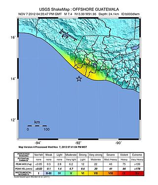
The 2012 Guatemala earthquake occurred on November 7 at . The shock had a moment magnitude of 7.4 and a maximum Mercalli Intensity of VII. The epicenter was located in the Pacific Ocean, 35 kilometres (22 mi) south of Champerico in the department of Retalhuleu. The affected region is earthquake-prone, where the Cocos Plate is being subducted along the Middle America Trench beneath the North American and the Caribbean Plates, near their triple junction.
The February 2001 El Salvador earthquake occurred with a moment magnitude of 6.6 on 13 February at 14:22:05 UTC. The epicentre was 15 miles (30 km) E of San Salvador, El Salvador, at a depth of 10 km. At least 315 people were killed, 3,399 were injured, and extensive damage affected the area. Another 16,752 homes were damaged and 44,759 destroyed. The most severe damage occurred in the San Juan Tepezontes-San Vicente-Cojutepeque area, though it was felt throughout the country and in neighboring Guatemala and Honduras. Landslides occurred in many areas of El Salvador.
Starting on December 28, 2019, and progressing into 2020, the southwestern part of the island of Puerto Rico was struck by an earthquake swarm, including 11 that were of magnitude 5 or greater. The largest and most damaging of this sequence was a magnitude 6.4 , which occurred on January 7 at 04:24 AST (08:24 UTC), with a maximum felt intensity of VIII (Severe) on the Modified Mercalli intensity scale. At least one person was killed, and several others were injured.
The 1942 Ecuador earthquake or the Guayaquil earthquake occurred on 13 May at 21:13 local time with a moment magnitude of Mw 7.9. The temblor struck the coastal (Esmeraldas) region of Manabí Province, Ecuador. It caused damage mainly to cities including Guayaquil, Portoviejo and Guaranda. More than 300 people were killed and the total cost of damage was about US$2.5 million. Ecuador's largest city Guayaquil was the most affected despite the significant distantce from the epicenter. Many reinforced concrete structures in a particular area in the city were completely destroyed, contributing to fatalities.
The 1979 Petatlán earthquake, also known as the IBERO earthquake occurred on March 14 at 05:07 local time in the Mexican state of Guerrero. The earthquake had a surface-wave magnitude of Ms 7.6 or moment magnitude of Mw 7.4 and maximum Modified Mercalli intensity of VIII (Severe). The epicenter, onshore, was located 12 km south southeast of Vallecitos de Zaragoza.
A moment magnitude Mw 7.0 or 7.1 earthquake occurred near the city of Acapulco in the Mexican state of Guerrero at on 7 September with an estimated intensity of VIII (Severe) on the MMI scale. The earthquake killed 13 people and injured at least 23 others. At least 1.6 million people in Mexico were affected by the earthquake which resulted in localized severe damage. The earthquake occurred on the anniversary of the 2017 Chiapas earthquake which measured Mw 8.2. It was also the largest earthquake in Mexico since the 2020 Oaxaca earthquake.

A major earthquake struck northern Peru on November 28, 2021, 5:52 a.m. local time with a magnitude of 7.5 on the moment magnitude scale between the Amazonas and Loreto departments of Peru. A maximum Modified Mercalli intensity (MMI) of VII was reported in the town of Santa Maria de Nieva according to the Geological Institute of Peru.
The 2022 Guatemala earthquake occurred on the early morning of February 16, 2022 in the southern regions of Guatemala. The quake measured a moment magnitude of 6.2 and reached a peak intensity of VI (Strong) on the Modified Mercalli Intensity scale. Damage was widespread but light in and around the capital, Guatemala City, resulting mostly in cracked walls and rockslides.
The 1959 Coatzacoalcos earthquake occurred at 02:25 local time on August 26 near the Mexican state of Veracruz. The earthquake measured 6.4 Mw at a depth of 21 km (13 mi), and had a maximum Modified Mercalli intensity of VIII (Severe). It had an epicenter immediately off the coast of Coatzacoalcos. The shallow back-arc thrust faulting earthquake damaged the cities of Acayucan, Coatzacoalcos, Jáltipan and Minatitlán. A total of 25 people died, including 10 from Jáltipan while a further 200 were injured. The Middle America Trench, a subduction zone that borders the southwestern coast of Mexico and Central America, accounts for much of the seismicity in Mexico. The eastern side of the country near the Gulf of Mexico rarely experiences large earthquakes although they have been recorded around the Veracruz area, where seismicity is higher compared to other parts of the gulf. Seismicity in the gulf is attributed to back-arc compression due to subduction.

The 1917 San Salvador earthquake occurred on June 7 at 18:55 local time near the Salvadoran capital. The hypocenter of the Mw 6.7 was at a shallow depth of 15 km (9.3 mi), and occurred along a shallow crustal fault near San Salvador. The earthquake caused significant destruction of the city and left approximately 1,050 dead. It was followed by an eruption on San Salvador that killed another 1,100. Only behind the earthquake of 1986, it is the second deadliest in El Salvador's history.

On 19 September 2022, a moment magnitude 7.6-7.7 earthquake struck between the Mexican states of Michoacán and Colima at 13:05:06 local time. The earthquake had a depth of 26.9 km (16.7 mi), resulting in a maximum intensity of VIII (Severe) on the Modified Mercalli intensity scale. The USGS reported the epicentre was 35 km (22 mi) southwest of the town of Aquila. Two people were killed and at least 35 others were injured across several states. A magnitude 6.8 aftershock struck on 22 September, causing three more deaths.
The 1822 Costa Rica earthquake had an estimated surface-wave magnitude of 7.5–7.6 and struck the nation's Caribbean coast. The earthquake largely affected the country's east coast and generated a tsunami. Thrust faulting was inferred as a plausible mechanism for the earthquake and its damage pattern was similar to a 1991 shock of similar magnitude. Damage was also recorded in neighbouring countries.
