
The 2005 Nias–Simeulue earthquake occurred on 28 March off the west coast of northern Sumatra, Indonesia. At least 915 people were killed, mostly on the island of Nias. The event caused panic in the region, which had already been devastated by the massive tsunami triggered by the 2004 Indian Ocean earthquake, but this earthquake generated a relatively small tsunami that caused limited damage. It was the third most powerful earthquake since 1965 in Indonesia.
The Sunda Trench, earlier known as and sometimes still indicated as the Java Trench, is an oceanic trench located in the Indian Ocean near Sumatra, formed where the Australian-Capricorn plates subduct under a part of the Eurasian Plate. It is 3,200 kilometres (2,000 mi) long with a maximum depth of 7,290 metres. Its maximum depth is the deepest point in the Indian Ocean. The trench stretches from the Lesser Sunda Islands past Java, around the southern coast of Sumatra to the Andaman Islands, and forms the boundary between the Indo-Australian Plate and Eurasian Plate. The trench is considered to be part of the alpida Belt as well as one of oceanic trenches around the northern edges of the Australian Plate.

An earthquake occurred on July 17, 2006, at along a subduction zone off the coast of west and central Java, a large and densely populated island in the Indonesian archipelago. The shock had a moment magnitude of 7.7 and a maximum perceived intensity of IV (Light) in Jakarta, the capital and largest city of Indonesia. There were no direct effects of the earthquake's shaking due to its low intensity, and the large loss of life from the event was due to the resulting tsunami, which inundated a 300 km (190 mi) portion of the Java coast that had been unaffected by the earlier 2004 Indian Ocean earthquake and tsunami that was off the coast of Sumatra. The July 2006 earthquake was also centered in the Indian Ocean, 180 kilometers (110 mi) from the coast of Java, and had a duration of more than three minutes.

The September 2007 Sumatra earthquakes were a series of megathrust earthquakes that struck the Sunda Trench off the coast of Sumatra, Indonesia, with three of magnitude 7 or greater. A series of tsunami bulletins was issued for the area. The most powerful of the series had a magnitude of 8.4, which makes it in the top 20 of the largest earthquakes ever recorded on a seismograph.
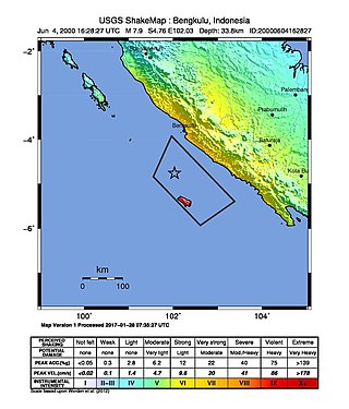
At 23:28 local time on June 4, 2000, southern Sumatra, Indonesia was struck by an earthquake of moment magnitude 7.9 with a maximum Mercalli intensity of VI (Strong). The event occurred off the coast near Enggano Island. There were more than 100 fatalities and up to 2,585 injuries. Over 730 aftershocks shook the area afterwards, one just eleven minutes after the mainshock.

The first of the 2009 Sumatra earthquakes occurred on 30 September off the coast of Sumatra, Indonesia with a moment magnitude of 7.6 at . The epicenter was 45 kilometres (28 mi) west-northwest of Padang, West Sumatra, and 220 kilometres (140 mi) southwest of Pekanbaru, Riau. Government and authorities confirmed 1,115 dead, 1,214 severely injured and 1,688 slightly injured. The most deaths occurred in the areas of Padang Pariaman (675), Padang (313), Agam (80) and Pariaman (37). In addition, around 135,000 houses were severely damaged, 65,000 houses were moderately damaged and 79,000 houses were slightly damaged. An estimated 250,000 families have been affected by the earthquake through the total or partial loss of their homes and livelihoods.

The Sunda megathrust is a fault that extends approximately 5,500 km (3300 mi) from Myanmar (Burma) in the north, running along the southwestern side of Sumatra, to the south of Java and Bali before terminating near Australia. It is a megathrust, located at a convergent plate boundary where it forms the interface between the overriding Eurasian plate and the subducting Indo-Australian plate. It is one of the most seismogenic structures on Earth, being responsible for many great and giant earthquakes, including the 2004 Indian Ocean earthquake and tsunami that killed over 227,000 people. The Sunda megathrust can be divided into the Andaman Megathrust, Sumatra(n) Megathrust and Java(n) Megathrust. The Bali-Sumbawa segment is much less active and therefore does not have the "megathrust" term associated with it.

The 1861 Sumatra earthquake occurred on 16 February and was the last in a sequences of earthquakes that ruptured adjacent parts of the Sumatran segment of the Sunda megathrust. It caused a devastating tsunami which led to several thousand fatalities. The earthquake was felt as far away as the Malay peninsula and the eastern part of Java. The rupture area for the 2005 Nias–Simeulue earthquake is similar to that estimated for the 1861 event.

The 2010 Mentawai earthquake occurred with a moment magnitude of 7.8 on 25 October off the western coast of Sumatra at 21:42 local time. The earthquake occurred on the same fault that produced the 2004 Indian Ocean earthquake. It was widely felt across the provinces of Bengkulu and West Sumatra and resulted in a substantial localized tsunami that struck the Mentawai Islands.
The 2002 Sumatra earthquake occurred at 01:26 UTC on 2 November. It had a magnitude of 7.4 on the moment magnitude scale with an epicenter just north of Simeulue island and caused three deaths. This earthquake is regarded as a foreshock of the 2004 Indian Ocean earthquake, which had an epicenter about 60 km to the northwest.
The 2012 Indian Ocean earthquakes were magnitude 8.6 and 8.2 Mw undersea earthquakes that struck near the Indonesian province of Aceh on 11 April at 15:38 local time. Initially, authorities feared that the initial earthquake would cause a tsunami and warnings were issued across the Indian Ocean; however, these warnings were subsequently cancelled. These were unusually strong intraplate earthquakes and the largest strike-slip earthquake ever recorded.

The 2016 Sumatra earthquake was a 7.8 magnitude earthquake which struck on 2 March 2016 in the Indian Ocean, approximately 800 kilometers southwest of Sumatra in Indonesia. Tsunami warnings were issued for Indonesia and Australia, but were withdrawn two hours later. There were no deaths directly related to the earthquake.
The 1907 Sumatra earthquake occurred on January 4 at 05:19:12 UTC. The re-estimated moment magnitude (Mw) is 8.2 to 8.4, with an epicentre close to Simeulue, off Sumatra. An earlier study re-estimated a surface-wave magnitude (Ms) of 7.5 to 8.0. It triggered a widespread and damaging Indian Ocean wide tsunami that caused at least 2,188 deaths on Sumatra. The low observed intensity compared to the size of the tsunami has led to its interpretation as a tsunami earthquake. Higher levels of shaking observed on Nias are attributed to a large aftershock, less than an hour later. The tsunami gave rise to the S'mong legend, which is credited with saving many lives during the 2004 earthquake.

On February 20, 2008, an earthquake with a moment magnitude of 7.4 struck off the coast of Sumatra at a hypocentre depth of 26 km. The earthquake had an epicenter located on the island of Simeulue, northwest from Sinabang, a small town on the island. Three people were killed and an additional 25 seriously injured as a result of the earthquake.
On the morning of January 5, 1699, a violent earthquake rocked the then Dutch East Indies city of Batavia on the island of Java, now known as the Indonesian capital city of Jakarta. Dutch accounts of the event described the earthquake as being "so heavy and strong" and beyond comparable to other known earthquakes. This event was so large that it was felt throughout west Java, and southern Sumatra.

The 1995 Kerinci earthquake struck near Sungai Penuh in Jambi Province on the island of Sumatra, Indonesia. It earthquake occurred at 01:18 WIB local time on October 7. The earthquake measured 6.7 on the moment magnitude scale, and 6.9–7.0 on the surface wave magnitude scale. Between 84 and possibly even 100 people were killed in the earthquake. An extimated 4,000 buildings collapsed or were seriously damaged while a further 5,000 suffered some damage.

An earthquake occurred 112 km, offshore, north of Maumere in the Flores Sea on 14 December. The quake had a moment magnitude of 7.3 according to the United States Geological Survey (USGS). One person was killed and 173 others suffered injuries.
The 1843 Nias earthquake off the northern coast of Sumatra, Indonesia caused severe damage when it triggered a tsunami along the coastline. The earthquake with a moment magnitude (Mw ) of 7.8 lasted nine minutes, collapsing many homes in Sumatra and Nias. It was assigned a maximum modified Mercalli intensity of XI (Extreme).

On 25 February 2022 at 08:39 WIB, a moment magnitude (Mw ) 6.2 earthquake struck West Sumatra, Indonesia at a depth of 4.0 km (2.5 mi). Preceded by one foreshock and followed by over 200 aftershocks, the mainshock had an epicenter at the foot of Mount Talakmau in Pasaman Regency. The mainshock was the result of strike-slip faulting along a previously unidentified segment of the Great Sumatran Fault. At least 27 people died, 457 were injured, and 19,221 others were displaced. It inflicted 780 million Indonesian rupiahs (Rp) worth of damage. The heaviest damage was recorded at three villages around Mount Talakmau. Landslides and flash floods caused additional damage and casualties.
The 1933 Sumatra earthquake or Liwa earthquake occurred in West Lampung Regency, Lampung Province, Indonesia on June 25. The earthquake had an estimated surface-wave magnitude (Ms ) of 7.7 occurring at a shallow depth of 20 km. It had an epicenter onshore, devastating the city of Liwa. At least 788 people were reported killed, although the death toll may have been in the thousands. Aftershocks followed, including one which was strong enough to cause additional fatalities. The mainshock also triggered a nearby volcanic eruption two weeks later, killing some people.
