Vanua Levu, formerly known as Sandalwood Island, is the second largest island of Fiji. Located 64 kilometres to the north of the larger Viti Levu, the island has an area of 5,587.1 square kilometres (2,157.2 sq mi) and a population of 135,961 as of 2007.

Lautoka is the second largest city in Fiji. It is on the west coast of the island of Viti Levu, in the Ba Province of the Western Division. Lying in the heart of Fiji's sugar cane-growing region, the city has come to be known as the Sugar City. Covering an area of 32 square kilometres, it had a population of 71,573 at the 2017 census, the most recent to date.

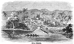
Savusavu is a town in the Fijian Province of Cakaudrove. The town is located on the south coast of Vanua Levu Island and had a population of 3,372 in the 2007 census.

Labasa is a town in Fiji with a population of 28,500 at the most recent census held in 2010.
Tovata is one of three confederacies comprising the Fijian House of Chiefs, to which all of Fiji's chiefs belong.

The Northern Division is one of four Divisions into which Fiji's fourteen Provinces are grouped for local government purposes. The administrative centre of the Division, where main governmental departments are located, is Labasa.

ʻEnele Maʻafuʻotuʻitonga, commonly known as Maʻafu, was a Pacific islander who held important titles in two countries in the Pacific. He was a traditional Tongan Prince and a Fijian chief nominated and installed by the Tovata chiefs of Lakeba and Vanua Balavu as 'Tui Lau' in 1869. This title was ratified by a wider council of Fijian chiefs and subsequently formalised under British colonial administration. In 1847, Maʻafu went to Fiji in an expedition to Vanua Balavu to investigate the killing of a preacher.
The Vanua Levu Group is an archipelago in northern Fiji. It takes its name from its predominant island, Vanua Levu. Among the other island in the group, the most important is Taveuni. Other islands in the group include Laucala, Matagi, Namena Lala, Qamea, Rabi, Vorovoro and Yadua Tabu. They have an aggregate area of 6,199 square kilometres, with a total population of 140,016 at the 1996 census, the last held.
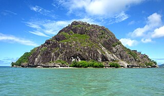
The Ringgold Isles are an archipelago in Fiji, forming an outlier group to Vanua Levu. The Budd, Nukusemanu, and Heemskercq Reefs form part of the group. The group is mostly uninhabited, but Qelelevu has a small village. In 2008 Pacific rats were eradicated from seven islands of the group in an endeavour facilitated by BirdLife International's Fiji Programme.
Cakaudrove is one of fourteen provinces of Fiji, and one of three based principally on the northern island of Vanua Levu, occupying the south-eastern third of the island and including the nearby islands of Taveuni, Rabi, Kioa, and numerous other islands in the Vanua Levu Group. It has a total land area of 2,816 square kilometers, with a population of 50,469 at the most recent census in 2017, making it the seventh most populous province. The only major town is Savusavu, with a population of 3,372 in 2007.
Macuata is one of Fiji's fourteen Provinces, and one of three based principally on the northern island of Vanua Levu, occupying the north-eastern 40 percent of the island. It has a land area of 2004 square kilometers.
Ra is one of the fourteen provinces of Fiji. Occupying the northern area of Viti Levu, the largest island, it is one of eight Viti Levu-based Provinces. With a land area of 1,341 square kilometers, it had a population of 30,432 in 2017 census. The main urban centre is at Vaileka, with a population of 3,361 in 1996.

Tailevu is one of the 14 provinces of Fiji. Its capital town is Nausori which lies along the banks of the Rewa River.
Isireli Tuvuki is a former Fijian politician, who served in the Cabinet from 2001 to 2006 as Assistant Minister for Agriculture, Sugar, and Land Resettlement. In these roles, he assisted Ilaitia Tuisese, who held these portfolios.

The Diocese of Polynesia, or the Tikanga Pasefika serves Anglicans in Fiji, Tonga, Samoa and the Cook Islands, within the Anglican Church in Aotearoa, New Zealand and Polynesia. The diocese's first bishop was consecrated in 1908. The diocese's cathedral is Holy Trinity Cathedral in Suva, Fiji.

Severe Tropical Cyclone Daman was the strongest cyclone of the 2007–08 South Pacific cyclone season. Cyclone Daman was the fourth tropical depression and the first severe tropical cyclone to form east of longitude 180° during the 2007–08 South Pacific cyclone season. Due to the severity of the storm, the name Daman was retired and replaced with Denia.
Tropical Cyclone Cliff was first noted as a weak tropical disturbance on April 1, 2007, within a trough of low pressure about 210 km (130 mi) to the southwest of Rotuma. Over the next couple of days the system drifted towards the southeast and Fiji, in an area of strong wind shear. During April 3, the system slightly accelerated, as it moved towards the south-southeast before the westerly wind shear around the system relaxed sufficiently to allow the depression to consolidate while it was located near Vanua Levu.

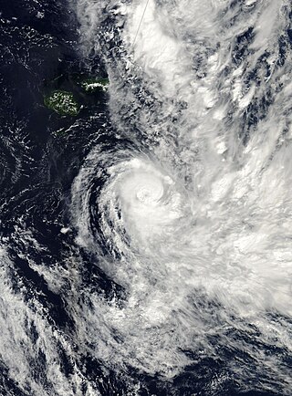
Severe Tropical Cyclone Ami was one of the worst cyclones to affect Fiji. The system was the third cyclone and the second severe tropical cyclone of the 2002–03 South Pacific cyclone season. Cyclone Ami developed from a low-pressure area east of Tuvalu on January 12. Originally, the storm moved slowly towards the southwest early in its existence. Influenced by an upper-level trough, Ami slowed and began moving towards the south and then southeast. The cyclone attained severe tropical cyclone intensity on January 13. Ami made its first landfall at Vanua Levu, before subsequently making another landfall on Taveuni. Still intensifying, Ami reached peak intensity as an equivalent Category 3 cyclone on the Australian and Fiji cyclone scales on January 14. Accelerating to the southeast, the cyclone began to cross over cool sea surface temperatures and encountered wind shear. Ami transitioned into an extratropical cyclone the day after.

Severe Tropical Cyclone Yasa was the second Category 5 severe tropical cyclone in 2020 after Harold in the 2019–20 South Pacific cyclone season. Yasa was the second tropical disturbance, as well as the first tropical cyclone and severe tropical cyclone of the 2020–21 South Pacific cyclone season. Yasa was first noted as an area of low pressure to the north of Port Vila in Vanuatu during December 10. Over the next few days, the system gradually developed further as it absorbed Tropical Depression 01F, before it was classified as a tropical cyclone and named Yasa by the Fiji Meteorological Service on December 13.

Severe Tropical Cyclone Ana was one of three tropical cyclones to impact the island nation of Fiji towards the end of January 2021. The fifth tropical disturbance, third tropical cyclone and second severe tropical cyclone of the 2020–21 South Pacific cyclone season, Ana was first noted as Tropical Disturbance 05F during January 26, while it was located about 220 km (135 mi) to the northeast of Port Vila in Vanuatu. Over the next few days, the system moved eastwards and gradually developed further, before it was declared to be a tropical cyclone and named Ana during January 29. Over the next day, the system moved south-eastwards towards Fiji before it made landfall on the island of Viti Levu. After emerging into the Pacific Ocean, the system intensified into a Category 3 severe tropical cyclone, before it rapidly degenerated into a subtropical low during February 1.