Related Research Articles
Kadavu, with an area of 411 square kilometres (159 sq mi), is the fourth largest island in Fiji, and the largest island in the Kadavu Group, a volcanic archipelago consisting of Kadavu, Ono, Galoa and a number of smaller islands in the Great Astrolabe Reef. Its main administrative centre is Vunisea, which has an airport, a high school, a hospital, and a government station, on the Namalata Isthmus where the island is almost cut in two. Suva, Fiji's capital, lies 88 kilometres to the north of Kadavu. The population of the island province was 10,167 at the most recent census in 2007.
The Lau Islands of Fiji are situated in the southern Pacific Ocean, just east of the Koro Sea. Of this chain of about sixty islands and islets, about thirty are inhabited. The Lau Group covers a land area of 188 square miles, and had a population of 10,683 at the most recent census in 2007. While most of the northern Lau Group are high islands of volcanic origin, those of the south are mostly carbonate low islands.

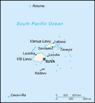
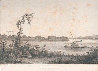
Ovalau is the sixth largest island in Fiji. It is located in Lomaiviti Archipelago. Situated at 17.70° South and 178.8° East,, the island is about 13 kilometers long and 10 kilometers wide. It covers a total area of 106.4 square kilometers and has a population of around 9,100, approximately half of the population of Lomaiviti Province over the 1956–2007 period. Levuka, Fiji's former capital, is the largest of 24 towns and villages on the island, and is the only urban area in Lomaiviti. All settlements are coastal, except Lovoni in the interior of the island.

The Lomaiviti archipelago of Fiji consists of seven main islands and a number of smaller ones. They cover a total area of 411 square kilometres (159 sq mi), and had a population of 15,657 at the most recent census in 2017. The largest town, with a population of 1,131 in 2007, is Levuka, which was Fiji's first modern town and served as the capital from 1871 to 1877.
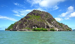
Yanuca Levu is a hilly steep islet in Fiji's Lomaiviti group, within Ovalau reef.

Rakiraki is a district in Fiji's Ra Province. It is located between Tavua and Korovou when travelling along the Kings Road, on the northern coast of Viti Levu, Fiji's largest island.

Bua is one of fourteen provinces of Fiji. Located in the west of the northern island of Vanua Levu, it is one of three northern provinces, and has a land area of 1,379 square kilometers within the three main districts of Bua, Vuya and Wainunu. Its population at the 2017 census was 15,466, making it the fifth least-populous Province.
Cakaudrove is one of fourteen provinces of Fiji, and one of three based principally on the northern island of Vanua Levu, occupying the south-eastern third of the island and including the nearby islands of Taveuni, Rabi, Kioa, and numerous other islands in the Vanua Levu Group. It has a total land area of 2,816 square kilometers, with a population of 50,469 at the most recent census in 2017, making it the seventh most populous province. The only major town is Savusavu, with a population of 3,372 in 2007.
Naitasiri is one of the 14 provinces of Fiji and one of eight located on Viti Levu, Fiji's largest island. It is located in Central Division.
Ra is one of the fourteen provinces of Fiji. Occupying the northern area of Viti Levu, the largest island, it is one of eight Viti Levu-based Provinces. With a land area of 1,341 square kilometers, it had a population of 30,432 in 2017 census. The main urban centre is at Vaileka, with a population of 3,361 in 1996.
Rewa is a province of Fiji. With a land area of 272 square kilometers, it includes the capital city of Suva and is in two parts — one including part of Suva's hinterland to the west and a noncontiguous area to the east, separated from the rest of Rewa by Naitasiri Province. The province had a population of 108,016 at the 2017 census, making it Fiji's third most populous.
Serua is one of Fiji's fourteen provinces. Its 830 square kilometers occupy the southernmost areas of Viti Levu, being one of 8 provinces based on Fiji's largest island. It had a population of 15,461 at the 2007 census.

Tailevu is one of the 14 provinces of Fiji. Its main town is Nausori, which lies along the banks of the Rewa River.

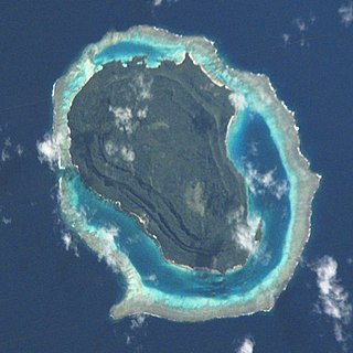
Moturiki is an island belonging to Fiji's Lomaiviti Archipelago. Covering an area of 10.9 square kilometers, it is situated at 17.45° South and 178.44° East. To the north-east is the nearby island of Ovalau.
Ba is a province of Fiji, occupying the north-western sector of Viti Levu, Fiji's largest island. It is one of fourteen provinces in the nation of Fiji, and one of eight based in Viti Levu. It is Fiji's most populous province, with a population of 247,708 – more than a quarter of the nation's total – at the 2017 census. It covers a land area of 2,634 km2 (1,017 sq mi), the largest of any province.

Nairai is an island of Fiji belonging to the Lomaiviti Archipelago. The island is of volcanic origin and has a land area of about 30 square kilometers. To the west of the island is Batiki, and to the south-west is Gau.
Tuvuca is a small island off Vanua Balavu in Fiji's Lau archipelago. It is a densely wooded and inhabited island and rises 800 feet above sea level at the highest point. There is only one village on the island, which has a population of around 180 people. There is a primary school. Tuvuca has untapped deposits of phosphate.

The Tikina of Lovoni is made up of the Fijian villages of Lovoni, Nasaumatua, Vuni-ivi-savu, Visoto, Nukutocia and Nacobo. The latter three villages are located on the coast of Ovalau. The paramount Chief of the Tikina of Lovoni which includes six villages is the Tui Wailevu the Vunivalu. The Lovoni Village Road is used by the inhabitants to access the nearby town of Levuka.
Kadavu Province is one of fourteen provinces of Fiji, and forms part of the Eastern Division, which also includes the provinces of Lau, Lomaiviti and Rotuma. Kadavu also belongs to the Burebasaga Confederacy, a hierarchy of chiefs from southern and western Fiji with Roko Tui Dreketi of Rewa as the paramount chief.

Lau Province is one of fourteen provinces of Fiji. Its capital is at Tubou, at the southern end of the island of Lakeba. The province forms part of the country's Eastern Division, and of the Tovata Confederacy, a traditional hierarchy of chiefs from northern and eastern Fiji.
References
- ↑ Fiji Bureau of Statistics (5 January 2018). "2017 Population and Housing Census - Release 1". Census 2017. Archived from the original on 20 March 2018. Retrieved 8 April 2018.
17°40′S178°48′E / 17.667°S 178.800°E
| | This article about a geographical location in Fiji is a stub. You can help Wikipedia by expanding it. |