Fiji is a group of volcanic islands in the South Pacific, lying about 4,450 kilometres (2,765 mi) southwest of Honolulu and 1,770 km (1,100 mi) north of New Zealand. Of the 332 islands and 522 smaller islets making up the archipelago, about 106 are permanently inhabited. The total land size is 18,272 km2 (7,055 sq mi). It has the 26th largest Exclusive Economic Zone of 1,282,978 km2 (495,361 sq mi).

Vanua Levu, formerly known as Sandalwood Island, is the second largest island of Fiji. Located 64 kilometres to the north of the larger Viti Levu, the island has an area of 5,587.1 square kilometres (2,157.2 sq mi) and a population of 135,961 as of 2007.

Lautoka is the third largest metropolitan area in Fiji. It is on the west coast of the island of Viti Levu, in the Ba Province of the Western Division. Lying in the heart of Fiji's sugar cane-growing region, the city has come to be known as the Sugar City. Covering an area of 32 square kilometres, it had a population of 71,573 at the 2017 census, the most recent to date.

Labasa is a town in Fiji with a population of 28,500 at the 2010 census.

Taveuni is the third-largest island in Fiji, after Viti Levu and Vanua Levu, with a total land area of 434 square kilometres. The cigar-shaped island, a massive shield volcano which rises from the floor of the Pacific Ocean, is situated 6.5 kilometres east of Vanua Levu, across the Somosomo Strait. It belongs to the Vanua Levu Group of islands and is part of Fiji's Cakaudrove Province within the Northern Division.

Koro is a volcanic island of Fiji that forms part of the Lomaiviti Archipelago. The Koro Sea is named after this volcanic island, which has a chain of basaltic cinder cones extending from north to south along its crest. With a land area of 105.3 square kilometres (40.7 sq mi), the 5-by-10-mile island is the seventh largest in Fiji. Its latitude is 17.18° North; its longitude is 179.24° East. Its population as of the 2017 census was 2,830 spread across 14 villages on the island. Eight villages are in Mudu District on the east coast and six are in Cawa District on the west coast. A roll-on/roll-off ferry services Koro weekly from Suva and also connects Koro to Vanua Levu to the north. Fiji Link provides one scheduled flight per week to Koro, usually on Friday from Nausori Airport.
Matagi, sometimes written Matangi, is an island the Vanua Levu Group in northern Fiji, situated 16°44 South 179° West. It is one of three tiny volcanic islands grouped to the east of Thurston Point on the island of Taveuni, the others being Qamea and Laucala. The horseshoe-shaped islet of 97 hectares lies 10 kilometers (6.2 mi) east of Thurston Point. Inaccessible until recently, this privately owned island has been turned into an up-market resort. Apart from diving, activities include fishing, windsurfing, sailing, water-skiing, and snorkelling. There is a speedboat link between Matagi and Taveuni.
Tavua is a town in Fiji, 91 kilometres from Nadi and 9 kilometres from the gold mining settlement of Vatukoula. It was formally incorporated as a Town in 1992 with the appointment of its first Mayor, Iliesa Vula from Tavualevu. The town covers a land area of 100 square kilometres, and had a population of 2,418 at the 1996 census.

Bua is one of fourteen provinces of Fiji. Located in the west of the northern island of Vanua Levu, it is one of three northern provinces, and has a land area of 1,379 square kilometers within the three main districts of Bua, Vuya and Wainunu. Its population at the 2017 census was 15,466, making it the fifth least-populous Province.
Cakaudrove is one of fourteen provinces of Fiji, and one of three based principally on the northern island of Vanua Levu, occupying the south-eastern third of the island and including the nearby islands of Taveuni, Rabi, Kioa, and numerous other islands in the Vanua Levu Group. It has a total land area of 2,816 square kilometers, with a population of 50,469 at the most recent census in 2017, making it the seventh most populous province. The only major town is Savusavu, with a population of 3,372 in 2007.
Ratu Kinijoji R. Maivalili was a Fijian Chief and former political leader. From 2001 to 2006, he represented the Province of Cakaudrove in the Senate as one of fourteen nominees of the Great Council of Chiefs. Previously, he sat in the House of Representatives representing the Cakaudrove West Fijian Communal Constituency, which he won in 1999 but lost in 2001.
Vijay Chand is a Fiji Indian politician who won the Labasa Indian Communal Constituency for the Labour Party in 2006 general election.
Vorovoro is an island in the province of Macuata in the Vanua Levu Group of northern Fiji, 40 minutes away from the town of Labasa by boat.
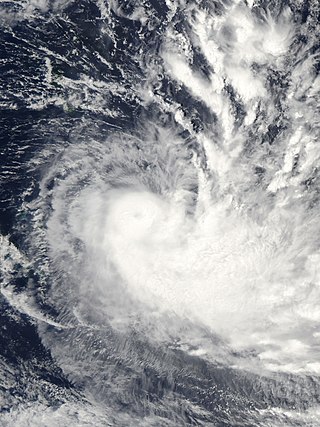
Severe Tropical Cyclone Gene was the deadliest storm as well as the most damaging tropical cyclone of the 2007–08 South Pacific cyclone season east of 160ºE. RSMC Nadi monitored Gene as the 12th tropical disturbance, as well as the fourth tropical cyclone and the third severe tropical cyclone to form west of 160ºE during the 2007–08 South Pacific cyclone season. Gene was also recognised by RSMC Nadi as the fifth tropical cyclone and fourth severe tropical cyclone to form within the South Pacific Ocean during the 2007-08 season.

Severe Tropical Cyclone Ami was one of the worst cyclones to affect Fiji. The system was the third cyclone and the second severe tropical cyclone of the 2002–03 South Pacific cyclone season. Cyclone Ami developed from a low-pressure area east of Tuvalu on January 12. Originally, the storm moved slowly towards the southwest early in its existence. Influenced by an upper-level trough, Ami slowed and began moving towards the south and then southeast. The cyclone attained severe tropical cyclone intensity on January 13. Ami made its first landfall at Vanua Levu, before subsequently making another landfall on Taveuni. Still intensifying, Ami reached peak intensity as a Category 3 cyclone on the Australian and Fiji cyclone scales on January 14. Accelerating to the southeast, the cyclone began to cross over cool sea surface temperatures and encountered wind shear. Ami transitioned into an extratropical cyclone the day after.
Seaqaqa is an unincorporated town in Fiji. It had a population of 394 in 1996, 816 in 2007, and 592 in 2017. The town has Seaqaqa F.C., a football club. Seaqaqa has a primary school, a college, and a health centre. Seaqaqa was the site of a brief and unsuccessful anti-colonial uprising in 1894. In the 1970s, an ambitious cane development scheme was realized in Seaqaqa.
Major William Edmund Willoughby-Tottenham was a British army major and later a politician in Fiji, where he served as a member of the Legislative Council in two spells between 1922 and 1937.
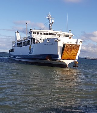
Patterson Brothers Shipping Company LTD is Fiji's longest running inter-island ferry operation bridging the gap between Viti Levu, Vanua Levu, and Ovalau daily. They also provide trips to Kadavu and Koro islands.

Severe Tropical Cyclone Yasa was the second Category 5 severe tropical cyclone in 2020 after Harold in the 2019–20 South Pacific cyclone season. Yasa was the second tropical disturbance, as well as the first tropical cyclone and severe tropical cyclone of the 2020–21 South Pacific cyclone season. Yasa was first noted as an area of low pressure to the north of Port Vila in Vanuatu during December 10. Over the next few days, the system gradually developed further as it absorbed Tropical Depression 01F, before it was classified as a tropical cyclone and named Yasa by the Fiji Meteorological Service on December 13.

Severe Tropical Cyclone Ana was one of three tropical cyclones to impact the island nation of Fiji towards the end of January 2021. The fifth tropical disturbance, third tropical cyclone and second severe tropical cyclone of the 2020–21 South Pacific cyclone season, Ana was first noted as Tropical Disturbance 05F during January 26, while it was located about 220 km (135 mi) to the northeast of Port Vila in Vanuatu. Over the next few days, the system moved eastwards and gradually developed further, before it was declared to be a tropical cyclone and named Ana during January 29. Over the next day, the system moved south-eastwards towards Fiji before it made landfall on the island of Viti Levu. After emerging into the Pacific Ocean, the system intensified into a Category 3 severe tropical cyclone, before it rapidly degenerated into a subtropical low during February 1.