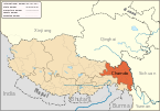
{{bo-textonly|ཆབ་མདོ་གྲོང་ཁྱེར།}}}}"},"other_name":{"wt":""},"nickname":{"wt":""},"settlement_type":{"wt":"[[Prefecture-level city]]"},"total_type":{"wt":""},"motto":{"wt":""},"image_skyline":{"wt":"Chamdo Mekong.png"},"imagesize":{"wt":""},"image_caption":{"wt":"[[Mekong River]] to the south of Chamdo Town"},"image_seal":{"wt":""},"seal_size":{"wt":""},"image_shield":{"wt":""},"shield_size":{"wt":""},"image_blank_emblem":{"wt":""},"blank_emblem_type":{"wt":""},"blank_emblem_size":{"wt":""},"image_map":{"wt":"Location of Qamdo Prefecture within Xizang (China).png"},"mapsize":{"wt":""},"map_caption":{"wt":"Location of Qamdo Prefecture within China"},"image_map1":{"wt":""},"mapsize1":{"wt":""},"map_caption1":{"wt":""},"image_dot_map":{"wt":""},"dot_mapsize":{"wt":""},"dot_map_caption":{"wt":""},"dot_x":{"wt":""},"dot_y":{"wt":""},"coordinates":{"wt":"{{coord|31.143|N|97.170|E|type:adm2nd_region:CN-54_source:Gaode|format=dms|display=it}}"},"coor_pinpoint":{"wt":"Qamdo municipal government"},"subdivision_type":{"wt":"Country"},"subdivision_name":{"wt":"People's Republic of China"},"subdivision_type1":{"wt":"[[Autonomous regions of the People's Republic of China|Autonomous region]]"},"subdivision_name1":{"wt":"[[Tibet Autonomous Region|Tibet]]"},"subdivision_type2":{"wt":"[[Administrative divisions of the People's Republic of China#County level|County-level divisions]]"},"subdivision_name2":{"wt":"{{ublist|1 district|10 counties}}"},"subdivision_type3":{"wt":""},"subdivision_name3":{"wt":""},"subdivision_type4":{"wt":""},"subdivision_name4":{"wt":""},"seat_type":{"wt":"Prefecture seat"},"seat":{"wt":"{{nowrap|[[Karub District]] ([[Chengguan, Chamdo|Chengguan]])}}"},"parts_type":{"wt":""},"parts_style":{"wt":""},"parts":{"wt":""},"p1":{"wt":""},"p2":{"wt":" \n"},"government_footnotes":{"wt":""},"government_type":{"wt":""},"leader_title":{"wt":""},"leader_name":{"wt":""},"leader_title1":{"wt":""},"leader_name1":{"wt":""},"leader_title2":{"wt":""},"leader_name2":{"wt":""},"leader_title3":{"wt":""},"leader_name3":{"wt":""},"leader_title4":{"wt":""},"leader_name4":{"wt":""},"established_title":{"wt":""},"established_date":{"wt":""},"established_title1":{"wt":""},"established_date1":{"wt":""},"established_title2":{"wt":""},"established_date2":{"wt":""},"established_title3":{"wt":""},"established_date3":{"wt":""},"founder":{"wt":""},"named_for":{"wt":""},"area_magnitude":{"wt":""},"unit_pref":{"wt":""},"area_footnotes":{"wt":""},"area_total_km2":{"wt":"110154"},"area_land_km2":{"wt":""},"area_water_km2":{"wt":""},"area_water_percent":{"wt":""},"area_urban_km2":{"wt":""},"area_metro_km2":{"wt":""},"area_blank1_title":{"wt":""},"area_blank1_km2":{"wt":""},"elevation_footnotes":{"wt":""},"elevation_m":{"wt":"3240"},"elevation_max_m":{"wt":""},"elevation_min_m":{"wt":""},"population_as_of":{"wt":"2019"},"population_footnotes":{"wt":""},"population_note":{"wt":""},"population_total":{"wt":"798,067"},"population_density_km2":{"wt":"auto"},"population_metro":{"wt":""},"population_density_metro_km2":{"wt":""},"population_urban":{"wt":""},"population_density_urban_km2":{"wt":""},"population_blank1_title":{"wt":""},"population_blank1":{"wt":""},"population_density_blank1_km2":{"wt":""},"demographics_type2":{"wt":"GDP{{Cite web|date=11 May 2022|title=2021年昌都市国民经济和社会发展统计公报|url=http://tjj.changdu.gov.cn/cdstjj/c102501/202205/cfcb50d0b8cf46e595761d3d30a026aa.shtml|access-date=12 May 2021|language=zh}}"},"demographics2_title1":{"wt":"Total"},"demographics2_info1":{"wt":"[[CN¥]] 27.9 billion
[[US$]] 4.3 billion"},"demographics2_title2":{"wt":"Per capita"},"demographics2_info2":{"wt":"CN¥ 36,574
US$ 5,668\n"},"timezone":{"wt":"[[China Standard Time|China Standard]]"},"utc_offset":{"wt":"+8\n"},"postal_code_type":{"wt":"[[Postal code of China|Postal code]]"},"postal_code":{"wt":""},"area_code":{"wt":""},"iso_code":{"wt":"[[ISO 3166-2:CN|CN-XZ-03]]"},"blank4_name":{"wt":""},"blank4_info":{"wt":""},"blank5_name":{"wt":""},"blank5_info":{"wt":""},"website":{"wt":""},"footnotes":{"wt":""}},"i":0}}]}" id="mwCg">Prefecture-level city in Tibet, People's Republic of China
Qamdo 昌都市 ཆབ་མདོ་གྲོང་ཁྱེར། | |
---|---|
Coordinates(Qamdo municipal government): 31°08′35″N97°10′12″E / 31.143°N 97.170°E | |
Country | People's Republic of China |
Autonomous region | Tibet |
County-level divisions |
|
Prefecture seat | Karub District (Chengguan) |
Area | |
• Total | 110,154 km2 (42,531 sq mi) |
Elevation | 3,240 m (10,630 ft) |
Population (2019) | |
• Total | 798,067 |
• Density | 7.2/km2 (19/sq mi) |
GDP [1] | |
• Total | CN¥ 27.9 billion US$ 4.3 billion |
• Per capita | CN¥ 36,574 US$ 5,668 |
Time zone | UTC+8 (China Standard) |
ISO 3166 code | CN-XZ-03 |
PINYIN= Changdu Zhen
Qamdo | |||||||
---|---|---|---|---|---|---|---|
Chinese name | |||||||
Chinese | 昌都 | ||||||
| |||||||
Tibetan name | |||||||
Tibetan | ཆབ་མདོ། | ||||||
|
Chamdo,officially Qamdo [2] [3] (Tibetan :ཆབ་མདོ, Wylie :chab mdo, ZYPY :qamdo) and also known in Chinese as Changdu (Chinese :昌都; pinyin :Chang Du), [4] is a prefecture-level city in the eastern part of the Tibet Autonomous Region,China. Its seat is the town of Chengguan in Karuo District. Chamdo is Tibet's third largest city after Lhasa and Shigatse. [5]
Chamdo is divided into 11 county-level divisions:one district and ten counties. The main district is Karuo District. Other counties include Jonda County,Gonjo County,Riwoche County,Dengqen County,Zhag'yab County,Baxoi County,Zognang County,Maarkam County,Lhorong County,and Banbar County.
On 11 July 2014 Chamdo Prefecture was upgraded into a prefecture-level city. [6]
Languages spoken in Chamdo include Khams Tibetan and the Chamdo languages of Lamo,Larong,and Drag-yab. [7]
Changdu Bangda Airport,opened in 1994,is located 126 kilometres (78 miles) from Chengguan Town in Karub District. The long commute (2.5 hours by mountain road) is the result of no flat land closer to the city being available to construct an airport.
China National Highway 214 and China National Highway 317 are the main roads in and out of Chamdo.
The city is subdivided into 11 county-level divisions:1 district and 10 counties
Map | ||||||||
---|---|---|---|---|---|---|---|---|
Name | Hanzi | Hanyu Pinyin | Tibetan | Wylie | Population (2010 Census) | Area (km2) | Density (/km2) | |
Karuo District | 卡若区 | KǎruòQū | མཁར་རོ་ཆུས། | mkhar ro chus | 116,500 | 10,794 | 10.79 | |
Jomda County | 江达县 | JiāngdáXiàn | འཇོ་མདའ་རྫོང་། | 'jo mda' rdzong | 76,026 | 13,164 | 5.77 | |
Gonjo County | 贡觉县 | GòngjuéXiàn | གོ་འཇོ་རྫོང་། | go 'jo rdzong | 40,434 | 6,323 | 6.39 | |
RiwoqêCounty | 类乌齐县 | LèiwūqíXiàn | རི་བོ་ཆེ་རྫོང་། | ri bo che rdzong | 49,870 | 6,355 | 7.84 | |
Dêngqên County | 丁青县 | Dīngqīng Xiàn | སྟེང་ཆེན་རྫོང་། | steng chen rdzong | 69,888 | 12,408 | 5.63 | |
Zhag'yab County | 察雅县 | CháyǎXiàn | བྲག་གཡབ་རྫོང་། | brag g-yab rdzong | 56,789 | 8,251 | 6.88 | |
Baxoi County | 八宿县 | BāsùXiàn | དཔའ་ཤོད་རྫོང་། | dpa' shod rdzong | 39,021 | 12,336 | 3.16 | |
Zogang County | 左贡县 | Zuǒgòng Xiàn | མཛོ་སྒང་རྫོང་། | mdzo sgang rdzong | 44,320 | 11,837 | 3.74 | |
Markam County | 芒康县 | Mángkāng Xiàn | སྨར་ཁམས་རྫོང་། | smar khams rdzong | 81,399 | 11,576 | 7.03 | |
Lhorong County | 洛隆县 | Luòlóng Xiàn | ལྷོ་རོང་རྫོང་། | lho rong rdzong | 47,491 | 8,048 | 5.90 | |
Banbar County | 边坝县 | BiānbàXiàn | དཔལ་འབར་རྫོང་། | dpal 'bar rdzong | 35,767 | 8,774 | 4.07 |
Chamdo has a humid continental climate (Köppen:Dwb) in the Karub District and an alpine subarctic climate (Köppen:Dwc) in other counties.
Climate data for Chamdo (Karuo District),elevation 3,315 m (10,876 ft),(1991–2020 normals,extremes 1981–2010) | |||||||||||||
---|---|---|---|---|---|---|---|---|---|---|---|---|---|
Month | Jan | Feb | Mar | Apr | May | Jun | Jul | Aug | Sep | Oct | Nov | Dec | Year |
Record high °C (°F) | 21.8 (71.2) | 21.4 (70.5) | 26.1 (79.0) | 28.1 (82.6) | 29.5 (85.1) | 32.7 (90.9) | 32.0 (89.6) | 30.8 (87.4) | 30.5 (86.9) | 27.7 (81.9) | 22.3 (72.1) | 20.2 (68.4) | 32.7 (90.9) |
Mean daily maximum °C (°F) | 8.8 (47.8) | 10.7 (51.3) | 13.5 (56.3) | 16.9 (62.4) | 21.0 (69.8) | 23.8 (74.8) | 24.3 (75.7) | 23.9 (75.0) | 21.9 (71.4) | 17.5 (63.5) | 13.2 (55.8) | 10.0 (50.0) | 17.1 (62.8) |
Daily mean °C (°F) | −1.5 (29.3) | 1.4 (34.5) | 4.8 (40.6) | 8.3 (46.9) | 12.4 (54.3) | 15.6 (60.1) | 16.4 (61.5) | 15.8 (60.4) | 13.4 (56.1) | 8.4 (47.1) | 2.8 (37.0) | −1.1 (30.0) | 8.1 (46.5) |
Mean daily minimum °C (°F) | −9.4 (15.1) | −6.4 (20.5) | −2.3 (27.9) | 1.7 (35.1) | 5.7 (42.3) | 9.5 (49.1) | 10.9 (51.6) | 10.3 (50.5) | 7.7 (45.9) | 2.1 (35.8) | −4.6 (23.7) | −8.9 (16.0) | 1.4 (34.5) |
Record low °C (°F) | −19.4 (−2.9) | −17.4 (0.7) | −13.0 (8.6) | −7.7 (18.1) | −4.0 (24.8) | 1.1 (34.0) | 2.9 (37.2) | 1.1 (34.0) | −0.9 (30.4) | −7.0 (19.4) | −13.6 (7.5) | −20.7 (−5.3) | −20.7 (−5.3) |
Average precipitation mm (inches) | 1.6 (0.06) | 4.0 (0.16) | 10.5 (0.41) | 23.9 (0.94) | 42.2 (1.66) | 80.7 (3.18) | 110.7 (4.36) | 102.8 (4.05) | 75.2 (2.96) | 33.1 (1.30) | 4.8 (0.19) | 1.3 (0.05) | 490.8 (19.32) |
Average precipitation days (≥0.1 mm) | 2.2 | 3.6 | 6.3 | 11.3 | 13.5 | 18.6 | 19.9 | 18.9 | 17.0 | 9.8 | 2.9 | 1.3 | 125.3 |
Average snowy days | 3.9 | 7.3 | 11.0 | 6.9 | 0.6 | 0.1 | 0 | 0 | 0.1 | 2.9 | 4.8 | 2.9 | 40.5 |
Average relative humidity (%) | 34 | 35 | 40 | 47 | 49 | 58 | 65 | 66 | 66 | 58 | 45 | 37 | 50 |
Mean monthly sunshine hours | 204.1 | 184.8 | 202.9 | 201.4 | 215.1 | 188.9 | 190.2 | 192.6 | 192.4 | 199.0 | 205.0 | 212.3 | 2,388.7 |
Percent possible sunshine | 63 | 59 | 54 | 52 | 50 | 45 | 44 | 47 | 53 | 57 | 65 | 68 | 55 |
Source:China Meteorological Administration [8] [9] |
Lincang is a prefecture-level city located in the southwest of Yunnan province,People's Republic of China.
Ulanqab or Ulan Chab is a region administered as a prefecture-level city in south-central Inner Mongolia,China. Its administrative centre is in Jining District,which was formerly a county-level city. It was established as a prefecture-level city on 1 December 2003,formed from the former Ulanqab League. The Ulanqab Stadium is located in the city.
Chamdo is a prefecture-level city in Tibet Autonomous Region.
Karub District also known as Kharro or Karuo,is a district in Qamdo,in the Tibet Autonomous Region of China,and the seat of government of Qamdo. Karuo has an area of 10,700 km2 and a population of 78,000,of which 90% are Tibetan. The average temperature is 7.6 °C,with average temperatures of −2.3 °C in January and 16.3 °C in July. The average precipitation is 467 mm per year.
Yushu Tibetan Autonomous Prefecture,also transliterated as Yüxü or Yulshul,is an autonomous prefecture of Southwestern Qinghai Province,China. Largely inhabited by Tibetans,the prefecture has an area of 188,794 square kilometres (72,894 sq mi) and its seat is located in the town of Gyêgu in Yushu County,which is the place of the old Tibetan trade mart of Jyekundo. The official source of the Yellow River lies within the prefecture. Historically,the area belongs to the cultural realm of Kham in Eastern Tibet.
Ngari Prefecture or Ali Prefecture is a prefecture of China's Tibet Autonomous Region covering Western Tibet,whose traditional name is Ngari Khorsum. Its administrative centre and largest settlement is the town of Shiquanhe. It is one of the least densely populated areas in the world,with 0.3 people per kilometer.
Nyingchi,also known as Linzhi or Nyingtri,is a prefecture-level city in the southeast of the Tibet Autonomous Region in China. The administrative seat of Nyingchi is Bayi District.
Songpan County,former Songzhou,is a county of northwestern Sichuan province,China,and is one of the 13 counties administered by the Ngawa Tibetan and Qiang Autonomous Prefecture. It has an area of 8,486 square kilometres (3,276 sq mi),and a population of approximately 68,000 composed of Tibetan,Qiang,Han and Hui populations.
Sog County is a county under the administration of the prefecture-level city of Nagqu of the Tibet Autonomous Region,China.
Riwoche is a county under the administration of the prefecture-level city of Chamdo in the Tibet Autonomous Region,China. The county lies in eastern Tibet and borders Qinghai province to the north.
Pasho County or Baxoi County is a county under the administration of Chamdo Prefecture in the Tibet Autonomous Region,China. The county seat is at Pema,which is also called the "Pasho Town". The county population is 35,273 (1999). It contains the Pomda Monastery and Rakwa Tso lake.
Zogong County is a county of the Chamdo Prefecture in the Tibet Autonomous Region,China,
Markam County is a county under the jurisdiction of the Chamdo in the Tibet Autonomous Region,China,bordering the provinces of Sichuan to the east and Yunnan to the south. It is the easternmost county-level division of the Tibet A.R.
Lhorong County is a county of Chamdo in the Tibet Autonomous Region,China. The county covers an area of 8,108 km2 (3,131 sq mi) and has a population of around 40,000 as of 2003. The word Lhorong means "valley in the south" or "river in the south" in Tibetan.
Zayul County (Tibetan:རྫ་ཡུལ་རྫོང) or Zayü is a county in the Nyingchi Prefecture in the southeastern part of the Tibet Autonomous Region,China.
Gar County,formerly Senge Tsangpo County,is a district (county) in the Ngari Prefecture of the western Tibet Autonomous Region of China. The main town is Shiquanhe (Sênggêkanbab),also called "Gar",on account of being the county seat,and "Ali",on account of being the seat of Ngari Prefecture.
Fuping County is a county located in the center of Shaanxi Province,China. It is the westernmost county-level division of the prefecture-level city of Weinan.
Shanyang County is a county in southeastern Shaanxi province,China,bordering Hubei province to the south. It is under the administration of the prefecture-level city of Shangluo and has an area of 3,515 km2 (1,357 sq mi) and a population of 440,000 as of 2004.
Huangyuan County is a county of Qinghai Province,China,it is under the administration of the prefecture-level city of Xining,the capital of Qinghai. It is under the administration of Xining city. The county seat is Chengguan Town,known in Mongolian as Dan Gar and in Tibetan as Tongkor.
Chamdo Region or Qamdo Region (Chinese:昌都地区;pinyin:ChāngdūDìqū;Wade–Giles:Chʻang1-tu1 Ti4-chʻü1) was a province-level area of the People's Republic of China comprising most of the western Kham region of traditional Tibet,where the Khampa,a subgroup of the Tibetan people,live. Chamdo split from Xikang Province in 1950 after the Battle of Chamdo. Chamdo was merged into Tibet Autonomous Region in 1965.
County-level divisions | ||
---|---|---|
Settlements |