Shangluo

Last updated • 1 min readFrom Wikipedia, The Free Encyclopedia
Shangluo
商洛市
Location of Shangluo Prefecture within Shaanxi (China).png
Location of Shangluo Prefecture within Shaanxi
Coordinates(Shangluo municipal government): 33°52′24″N109°55′07″E / 33.8734°N 109.9186°E / 33.8734; 109.9186
CountryPeople's Republic of China
Province Shaanxi
County-level divisions 1 district
6 counties
Township-level divisions 4 subdistricts
122 towns
Municipal seat Shangzhou District
Area
  Total19,587.31 km2 (7,562.70 sq mi)
Population
 (2010)
  Total2,341,742
  Density120/km2 (310/sq mi)
GDP [1]
  Total CN¥ 61.9 billion
US$ 9.9 billion
  Per capitaCN¥ 26,274
US$ 4,218
Time zone UTC+8 (China Standard)
Postal code
726000
Area code 0914
ISO 3166 code CN-SN-10
Licence plate prefixes 陕H
Administrative division code 611000
Website shangluo.gov.cn

Shangluo (Chinese : 商洛 ; pinyin :Shāngluò) is a prefecture-level city in southeastern Shaanxi province, People's Republic of China, bordering Henan to the northeast and Hubei to the southeast. Part of the Shannan region of the province, it is located in the eastern part of the Qin Mountains (Qin Ling). [2]

Contents

Climate

As with the other two anchoring cities of Shannan, Shangluo has a monsoon-influenced humid subtropical climate (Köppen Cwa), with cool winters, hot, humid summers, and ample precipitation by provincial standards. It experiences temperatures more moderate than Xi'an and the rest of the Wei River valley to the immediate north, especially so during summer due to the high elevation. The monthly 24-hour average temperature ranges from 0.5 °C (32.9 °F) in January to 24.3 °C (75.7 °F) in July, while the annual mean is 12.8 °C (55.0 °F). About 60% of the approximately 685.2 millimetres (27.0 in) of annual precipitation occurs from June to September. The frost-free period lasts 200 days, and there are about 2,000 hours of bright sunshine annually.

Climate data for Shangluo (Shangzhou District, 1981−2010 normals, extremes 1971-2010)
MonthJanFebMarAprMayJunJulAugSepOctNovDecYear
Record high °C (°F)17.9
(64.2)
23.7
(74.7)
30.3
(86.5)
34.6
(94.3)
36.3
(97.3)
40.7
(105.3)
38.2
(100.8)
38.4
(101.1)
39.3
(102.7)
31.6
(88.9)
26.4
(79.5)
21.3
(70.3)
40.7
(105.3)
Mean daily maximum °C (°F)6.2
(43.2)
8.9
(48.0)
13.9
(57.0)
20.6
(69.1)
25.2
(77.4)
28.9
(84.0)
30.0
(86.0)
28.5
(83.3)
23.9
(75.0)
19.0
(66.2)
13.5
(56.3)
7.9
(46.2)
18.9
(66.0)
Daily mean °C (°F)0.5
(32.9)
3.1
(37.6)
7.7
(45.9)
13.9
(57.0)
18.4
(65.1)
22.3
(72.1)
24.3
(75.7)
23.1
(73.6)
18.4
(65.1)
13.1
(55.6)
7.3
(45.1)
2.0
(35.6)
12.8
(55.1)
Mean daily minimum °C (°F)−3.7
(25.3)
−1.2
(29.8)
2.7
(36.9)
8.2
(46.8)
12.7
(54.9)
16.8
(62.2)
20.1
(68.2)
19.1
(66.4)
14.5
(58.1)
8.7
(47.7)
2.7
(36.9)
−2.2
(28.0)
8.2
(46.8)
Record low °C (°F)−13.7
(7.3)
−13.3
(8.1)
−8.6
(16.5)
−2.0
(28.4)
2.4
(36.3)
9.3
(48.7)
13.1
(55.6)
11.1
(52.0)
3.9
(39.0)
−4.6
(23.7)
−9.1
(15.6)
−13.9
(7.0)
−13.9
(7.0)
Average precipitation mm (inches)7.7
(0.30)
12.3
(0.48)
28.9
(1.14)
44.7
(1.76)
65.5
(2.58)
83.8
(3.30)
126.7
(4.99)
120.0
(4.72)
99.5
(3.92)
65.8
(2.59)
22.7
(0.89)
7.6
(0.30)
685.2
(26.97)
Average precipitation days (≥ 0.1 mm)5.05.38.79.210.210.512.711.711.610.46.53.7105.5
Average relative humidity (%)56576060646775787873635766
Source 1: China Meteorological Data Service Center [3]
Source 2: Weather China (precipitation days 19712000) [4]

Administration

Map of Shangluo administrative divisions
Division code [5] English nameSimplified ChinesePinyinArea [6]
(km2)
SeatPostal codeDivisions [7]
SubdistrictsTownsResidential communitiesVillages
611000Shangluo商洛市Shāngluò Shì19587.31Shangzhou District7260004122591773
611002Shangzhou District商州区Shāngzhōu Qū2645.62 Chengguan Subdistrict ( 城关街道 )72600041913406
611021Luonan County洛南县Luònán Xiàn2830.89 Chengguan ( 城关镇 )7261001922359
611022Danfeng County丹凤县Dānfèng Xiàn2407.58 Longjuzhai ( 龙驹寨镇 )726200166202
611023Shangnan County商南县Shāngnán Xiàn2315.44 Chengguan ( 城关镇 )726300136164
611024Shanyang County山阳县Shānyáng Xiàn3532.42 Chengguan ( 城关镇 726400236318
611025Zhen'an County镇安县Zhèn'ān Xiàn3487.39 Le'an ( 永乐镇 )711500194204
611026Zhashui County柞水县Zhàshuǐ Xiàn2367.97 Qianyou ( 乾佑镇 711400132120

Transport

Demographics

Shangluo Population Data
Division


Permanent residents [8] (November 2010) Hukou permits [9]
(late 2010)
TotalPercentageDensity (/km2)
Shangluo2,341,742100119.552,448,348
Shangzhou District531,64622.70200.95550,093
Luonan County441,64318.86156.01453,324
Danfeng County295,42412.62122.71304,448
Shangnan County221,5649.4695.69239,461
Shanyang County422,25518.03119.54449,658
Zhen'an County275,86211.7879.10296,170
Zhashui County153,3486.5564.76155,194

Sister cities

Related Research Articles

<span class="mw-page-title-main">Ankang</span> Prefecture-level city in Shaanxi, Peoples Republic of China

Ankang is a prefecture-level city in the south of Shaanxi Province in the People's Republic of China, bordering Hubei province to the east, Chongqing municipality to the south, and Sichuan province to the southwest.

<span class="mw-page-title-main">Tongchuan</span> Prefecture-level city in Shaanxi, Peoples Republic of China

Tongchuan is a prefecture-level city located in central Shaanxi province, People's Republic of China on the southern fringe of the Loess Plateau that defines the northern half of the province (Shanbei) and the northern reaches of the Guanzhong Plain.

<span class="mw-page-title-main">Danzhou</span> Prefecture-level city in Hainan, Peoples Republic of China

Danzhou is a prefecture-level city in the northwest of the Chinese island province of Hainan. The administrative seat and urban center of Danzhou is Nada Town. Danzhou was upgraded from a county-level city into a prefecture-level city in February 2015.

Longshan County is a county of Hunan Province, China, it is under the administration of Xiangxi Autonomous Prefecture.

<span class="mw-page-title-main">Lushui</span> County-level city in Yunnan, China

Lushui is a county-level city in and the seat of Nujiang Prefecture, western Yunnan Province, China. It borders Myanmar's Kachin State to the west and occupies the southern fifth of Nujiang Prefecture.

<span class="mw-page-title-main">Menghai County</span> County in Yunnan, China

Menghai County is a county under the jurisdiction of Xishuangbanna Dai Autonomous Prefecture, in the far south of Yunnan, China, bordering Burma's Shan State to the southwest. Meng is as variation of Mueang.

<span class="mw-page-title-main">Tonghe County</span> County in Heilongjiang, Peoples Republic of China

Tonghe County is under the administration of Harbin, the capital of Heilongjiang province, People's Republic of China, located on the northern (left) bank of the Songhua River. It is 161 kilometres (100 mi) to the east of central Harbin, bordering Yilan County to the east, Fangzheng County to the south, Mulan County to the west, as well as the prefecture-level city of Yichun to the north.

<span class="mw-page-title-main">Gong County, Sichuan</span> County in Sichuan, China

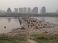
Gong County or Gongxian is a county located in southern Sichuan Province, China. It is under the administration of Yibin city. It is mainly known to travelers for the hanging coffins, a site which dates back nearly 3,000 years and is attributed to the Bo people, who died out around 400 years ago.

<span class="mw-page-title-main">Xinjin, Chengdu</span> District of Chengdu, Sichuan, China

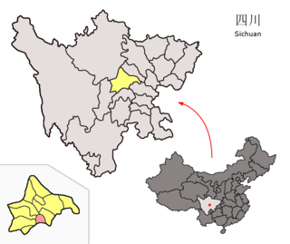
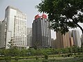
Xinjin District is a district of the City of Chengdu, the capital of Sichuan, China. It borders the prefecture-level city of Meishan to the south.

<span class="mw-page-title-main">Luoning County</span> County in Henan, Peoples Republic of China

Luoning County is a county in the west of Henan province, China. It is under the administration of the prefecture-level city of Luoyang.

Xintian County is a county of Hunan Province, China, it is under the administration of the prefecture-level city of Yongzhou.

Shuangpai County is a county in Hunan Province, China, it is under the administration of the prefecture-level city of Yongzhou. Shuangpai is also the 3rd smallest administrative unit by population in the counties and county-level cities of the province.

Yuanling County is a county of Hunan Province, China, it is under the administration of Huaihua Prefecture-level City.

Chenxi County is a county in Hunan Province, China, it is under the administration of Huaihua prefecture-level City.

<span class="mw-page-title-main">Xupu County</span> County in Hunan, Peoples Republic of China

Xupu County is a county of Hunan Province, China, it is under the administration of Huaihua Prefecturel-level City.

Huitong County is a county of Hunan Province, China, it is under the administration of Huaihua Prefecturel-level City.

Luxi County is a county of Hunan Province, China. It is under the administration of Xiangxi Autonomous Prefecture.

Huayuan County is a county of Hunan Province, China, it is under the administration of Xiangxi Autonomous Prefecture.

Baojing County is a county of Hunan Province, China, it is under the administration of Xiangxi Autonomous Prefecture.

<span class="mw-page-title-main">Yongshun County</span> County in Hunan, Peoples Republic of China

Yongshun County is a county of Hunan Province, China. It is under the administration of Xiangxi Autonomous Prefecture.

References

  1. 陕西省统计局、国家统计局陕西调查总队 (August 2016). 《陕西统计年鉴-2016》. 中国统计出版社. ISBN   978-7-5037-7918-3. Archived from the original on 2017-05-29.}}
  2. "Shangluo". Encyclopedia Britannica. Retrieved 2021-06-25.
  3. 中国地面气候标准值月值(1981-2010) (in Simplified Chinese). China Meteorological Data Service Center. Retrieved 29 November 2022.
  4. 商洛 - 气象数据 -中国天气网 (in Chinese). Weather China. Retrieved 29 November 2022.
  5. 国家统计局统计用区划代码. National Bureau of Statistics of the People's Republic of China. 2011. Archived 2013-04-05 at the Wayback Machine
  6. 第二次全国土地调查数据[ full citation needed ]
  7. 陕西省撤乡并镇及部分乡镇行政区划调整公告. Government of the People's Republic of China. July 2011.
  8. 《商洛市2010年第六次全国人口普查主要数据公报》[ full citation needed ]
  9. 《中华人民共和国全国分县市人口统计资料2010》[ full citation needed ]