Tumxuk is a county-level city in the western part of Xinjiang, China. The eastern part of Tumxuk is surrounded by Maralbexi County, Kashgar Prefecture. The smaller western part is near Kashgar.
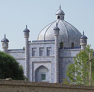
Artux or Artush is a county-level city and the capital of Kizilsu Kyrgyz Autonomous Prefecture in Xinjiang, China. The government seat is in Guangming Road Subdistrict. As of 2018, it has a population of 285,507 people, 81.4 per cent of whom are Uyghurs.
Payzawat County, also via SASM/GNC romanization as Payziwat County, and via Mandarin Chinese as Jiashi County is a county in Kashgar Prefecture, Xinjiang Uyghur Autonomous Region, China, on the western rim of the Taklamakan Desert. To the east, the county borders Maralbexi County, to the south Yopurga County.
Yopurga County is a county in northern Kashgar Prefecture, Xinjiang Uyghur Autonomous Region. More than 96% of the residents of the county are Uyghurs and live around oases at the western edge of the desolate Taklamakan Desert. The county is bordered to the north by Jiashi County, to the east by Maralbexi County, to the west by Shule County, to the southwest by Yengisar County and to the south by Yarkant County.
Yuli County as the official Romanized name, also transliterated from Mongolian as Lopnur County, is a county in the Xinjiang Uyghur Autonomous Region and is under the administration of the Bayin'gholin Mongol Autonomous Prefecture. It contains an area of 59,399 km2 (22,934 sq mi). According to the 2002 census, it has a population of 100,000.

Qiemo County as the official romanized name, also transliterated from Uyghur as Qarqan County, is a county under the administration of the Bayin'gholin Mongol Autonomous Prefecture in the Xinjiang Uyghur Autonomous Region of the People's Republic of China, bordering the Tibet Autonomous Region to the south. Its area is 138,645 square kilometers (53,531 sq mi) and, according to the 2002 census, it has a population of 60,000. The county seat is at Qiemo Town.

Ruoqiang County as the official romanized name, also transliterated from Uyghur as Qakilik County, is a county in the Xinjiang Uyghur Autonomous Region, China under the administration of the Bayingolin Mongol Autonomous Prefecture. It covers an area of 198,318 square kilometres (76,571 sq mi), making it the largest county-level division in the country.

Yutian County, also transliterated from Uyghur as Keriya County, is a county in Hotan Prefecture, Xinjiang Uyghur Autonomous Region, China. It is based at the Keriya Town, and is separate from Hotan County, which is another county in the same prefecture. The Yutian County has an area of 39,023 km2 (15,067 sq mi). According to the 2002 census, it has a population of 220,000. The county is bounded on the north by Aksu Prefecture, on the east by Minfeng/Niya County, on the west by Qira County and on the south by the Rutog and Gertse counties of the Tibet Autonomous Region.

Hotan Prefecture is located in the Tarim Basin region of southwestern Xinjiang, China, bordering the Tibet Autonomous Region to the south and Union Territory of Ladakh and Gilgit-Baltistan to the west. The vast majority of the Aksai Chin region which is disputed between China and India is administered as part of Hotan Prefecture. The seat of Hotan Prefecture is Hotan and its largest county by population is Karakax County. The vast majority of the residents of the prefecture are Muslim Uyghurs and live around oases situated between the desolate Taklamakan Desert and Kunlun Mountains.
Duodao District is a district of the city of Jingmen, Hubei, People's Republic of China.
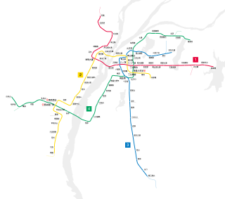
Nanchang Metro, officially Nanchang Rail Transit, is a rapid transit system in Nanchang, Jiangxi, China. As of 2021, four lines are operational. The Metro opened for commercial operation in December 2015. The network is currently 128.3 km (79.7 mi) in length in December 2021 with 4 lines. A total length of 163 km (101.3 mi) of network is planned, with Line 5 which is currently under planning.
Kunyu is a county-level city in Xinjiang Uyghur Autonomous Region, China. It is geographically located in Hotan Prefecture of Southern Xinjiang, but is de jure directly administered by the Xinjiang regional government.

Line 10, also known as the Bantian line of the Shenzhen Metro began construction at the end of 2015. The line opened on 18 August 2020. Line 10 has a length of 29.3 km (18.2 mi) and a total of 24 stations. It connects the Futian Checkpoint to Shuangyong Street. In the southern terminus of the line, a 555 meters long and 50.5 meters wide double deck underground depot capable of storing 16 trains will be constructed.
The 131st Regiment of Xinjiang Production and Construction Corps (新疆生产建设兵团第131团), also known as the 131th Regiment of the XPCC (兵团131团), together with its reclamation area, commonly known as the 131st Regiment Farm (兵团131团场), is an economic and paramilitary formed unit that is part of the 7th Division (兵团第七师). The Regiment is headquartered at Junggar Road (准噶尔路) in Kuytun City, Xinjiang Uygur Autonomous Region. It is composed of 21 agriculture construction companies. As of 2010 census, its population was 24,154.
The 7th Division is a division of the Xinjiang Production and Construction Corps (XPCC) based in Ili Kazakh Autonomous Prefecture and Karamay City, Xinjiang Uygur Autonomous Region, China. It is an economic and paramilitary unit formed in 1953 from the former 25th Infantry Division of the 9th Army of the 22nd Corps of the PLA. The 7th Agricultural Construction Division of the XPCC was approved and renamed to the present 7th Division of the XPCC in 2012. The division is composed of 10 regiments and a direct managed farm, and headquartered in Kuytun City.
The 8th Division is a division of the Xinjiang Production and Construction Corps (XPCC) distributed over Shihezi and Karamay cities, Manas and Shawan counties, Xinjiang Uygur Autonomous Region, China. It is an economic and paramilitary unit formed in 1953 from the former 26th Infantry Division of the 9th Army of the 22rd Corps of the PLA. The 8th Agricultural Construction Division was approved and renamed to the present 8th Division of the XPCC in 2012. The division is composed of 14 regiments, and headquartered in Shihezi City, it merges work in one official with Shihezi City. The Shihezi Reclamation Area of the 8th Division has an area of 5,851 square kilometers with a total population of 696,900 and a permanent population of 661,300, of that, the Shihezi City has an area of 460 square kilometers with a total population of 448,100 and a permanent population of 437,900. In the year of 2018, GDP of the 8th Division was CN¥54.85 billion, and the GDP per capita CN¥82,584 (US$12,480).
The Shihezi Economic and Technological Development Zone is an economic and technical development zone at national level located in the eastern suburbs of Shihezi City, Xinjiang Uygur Autonomous Region, China. It is situated east to Hetan Road (河滩路), west to the Dongsi and Dongqi Roads (东七路), south to the Northern Xinjiang railway, north to G312 National Highway, the total planning area is 11.2 square kilometers.