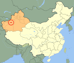
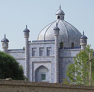
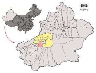
Aral, Xinjiang

Last updated
Aral
阿拉尔市 (Chinese)
ئارال شەھىرى (Uyghur)
China Xinjiang Aral.svg
Aral (red) in Xinjiang Province (orange) and China
Aral, Xinjiang
China Xinjiang Southern location map.svg
Red pog.svg
Aral
Location of the seat within Xinjiang
China Xinjiang adm location map.svg
Red pog.svg
Aral
Aral (Xinjiang)
China edcp location map.svg
Red pog.svg
Aral
Aral (China)
Coordinates(Aral municipal government): 40°32′53″N81°16′52″E / 40.548°N 81.281°E / 40.548; 81.281
Country China
Autonomous region Xinjiang
Municipal seat Jinyinchuan Road Subdistrict
Government
   CCP Secretary Ding Yiqiang (Political Commissar of the 1st Division)
  MayorXiao Yong (Commander of the 1st Division)
Area
  Total5,258.739 km2 (2,030.410 sq mi)
Population
 (2020) [1]
  Total328,241
  Density62/km2 (160/sq mi)
Time zone UTC+8 (China Standard [lower-alpha 1] )
Website www.ale.gov.cn
ئارالجىنيىنچۇەن يولى كوچا باشقارمىسى
Aral, Xinjiang
Chinese name
Simplified Chinese 阿拉尔
Traditional Chinese 阿拉爾
Jinyinchuen yoli kocha bashqarmisi659002001
Xinfu Road Subdistrict 幸福路街道Xìngfúlù Jiēdàoبەخت يولى كوچا باشقارمىسىBext yoli kocha bashqarmisi659002002
Xinfu Road Subdistrict 青松路街道Qīngsōnglù Jiēdàoچىڭسۇڭ يولى كوچا باشقارمىسىChingsung yoli kocha bashqarmisi659002003
Towns
Jinyinchuan Town
(1st Regiment Farm)*
金银川镇
(一团)
Jīnyínchuān Zhènجىنيىنچۇەن بازىرىJinyinchuen baziri659002100de facto administered by the 7th Division since May 2017
Xinjingzi Town
(2nd Regiment Farm)*
新井子镇
(二团)
Xīnjǐngzǐ Zhèn659002101
Ganquan Town
(3rd Regiment Farm)*
甘泉镇
(三团)
Gānquán Zhèn659002102
Yongning Town
(4th Regiment Farm)*
永宁镇
(四团)
Yǒngníng Zhènيۇڭنىڭ بازىرىYungning baziri659002103
Shahe Town
(5th Regiment Farm)*
沙河镇
(五团)
Yǒngníng Zhèn659002104de facto administered by the 11th Division (Construction Engineer Division) since May 2017
Shuangcheng Town
(6th Regiment Farm)*
双城镇
(六团)
Shuāngchéng Zhèn659002105
Huaqiao Town
(11th Regiment Farm)*
花桥镇
(十一团)
Huāqiáo Zhèn659002106
Xingfu Town
(13th Regiment Farm)*
幸福镇
(十三团)
Xìngfú Zhèn659002107
Jinyang Town
(14th Regiment Farm)*
金杨镇
(十四团)
Jīnyáng Zhèn659002108
Matan Town
(7th Regiment Farm)*
玛滩镇
(七团)
Mǎtān Zhèn659002109
Tamen Town
(8th Regiment Farm)*
塔门镇
(八团)
Tǎmén Zhèn659002110
Lihua Town
(9th Regiment Farm)*
梨花镇
(九团)
Líhuā Zhèn659002111
Chang'an Town
(10th Regiment Farm)*
昌安镇
(十团)
Chāng'ān Zhèn659002112
Tanan Town
(12th Regiment Farm)*
塔南镇
(十二团)
Tǎnán Zhèn659002113
Xinkailing Town
(16th Regiment Farm)*
新开岭镇
(十六团)
Xīnkāilǐng Zhèn659002114
Township
Tokay Township 托喀依乡Tuōkāyī Xiāngتوقاي يېزىسىToqay yëzisi659002200
township-equivalent regions
Aral Industrial Park工业园区Gōngyè Yuánqū659002402
Aral Western Industrial Park西工业园区Xī Gōngyè Yuánqū659002518

Geography

The city has an administrative area of 5,258.739 km2 (2,030.410 sq mi). It is bordered by mountainous regions to the north and northwest and the Taklamakan Desert to the east and south.

Demographics

As of 2015, 167,697 (93.6%) of the 179,214 residents of the county were Han Chinese, 6,036 (3.4%) were Uyghur and 5,481 were from other ethnic groups. [9]

Climate

Climate data for Aral (1991–2020 normals, extremes 1981–2010)
MonthJanFebMarAprMayJunJulAugSepOctNovDecYear
Record high °C (°F)9.4
(48.9)
15.8
(60.4)
28.1
(82.6)
35.7
(96.3)
37.2
(99.0)
38.5
(101.3)
39.5
(103.1)
40.6
(105.1)
35.5
(95.9)
30.0
(86.0)
22.2
(72.0)
10.6
(51.1)
40.6
(105.1)
Average high °C (°F)−0.1
(31.8)
6.5
(43.7)
15.4
(59.7)
24.0
(75.2)
28.7
(83.7)
31.6
(88.9)
32.6
(90.7)
31.4
(88.5)
27.4
(81.3)
20.8
(69.4)
10.8
(51.4)
1.7
(35.1)
19.2
(66.6)
Daily mean °C (°F)−8.1
(17.4)
−1.5
(29.3)
7.7
(45.9)
16.0
(60.8)
20.8
(69.4)
23.8
(74.8)
24.7
(76.5)
23.5
(74.3)
18.7
(65.7)
10.3
(50.5)
1.5
(34.7)
−5.7
(21.7)
11.0
(51.8)
Average low °C (°F)−14.6
(5.7)
−8.7
(16.3)
0.4
(32.7)
8.1
(46.6)
13.0
(55.4)
16.2
(61.2)
17.6
(63.7)
16.6
(61.9)
11.3
(52.3)
2.6
(36.7)
−4.8
(23.4)
−11.0
(12.2)
3.9
(39.0)
Record low °C (°F)−25.4
(−13.7)
−24.9
(−12.8)
−12.3
(9.9)
−3.3
(26.1)
3.3
(37.9)
7.2
(45.0)
9.3
(48.7)
7.9
(46.2)
2.9
(37.2)
−6.0
(21.2)
−14.1
(6.6)
−23.4
(−10.1)
−25.4
(−13.7)
Average precipitation mm (inches)1.0
(0.04)
1.1
(0.04)
0.9
(0.04)
0.9
(0.04)
6.6
(0.26)
11.3
(0.44)
11.9
(0.47)
11.7
(0.46)
6.8
(0.27)
1.8
(0.07)
0.9
(0.04)
1.2
(0.05)
56.1
(2.22)
Average precipitation days (≥ 0.1 mm)1.80.70.50.92.95.26.15.02.50.70.61.328.2
Average snowy days3.71.10.200000000.43.79.1
Average relative humidity (%)67564537404956596162657156
Mean monthly sunshine hours 193.2192.9213.3230.7269.3283.9291.4272.2256.0260.8212.1180.02,855.8
Percent possible sunshine 64635757606365657078736365
Source: China Meteorological Administration [10] [11]

Education

Tarim University is located in Aral.

Transportation

Ala'er Talimu Airport is a regional airport located at 12 km south from Aral city.

Aral Railway Station is located at southwest suburban of the city.

See also

Notes

  1. Locals in Xinjiang frequently observe UTC+6 (Xinjiang Time), 2 hours behind Beijing.

Related Research Articles

<span class="mw-page-title-main">Aksu City</span> County-level city in Xinjiang, China

Aksu is a city in and the seat of Aksu Prefecture, Xinjiang, lying at the northern edge of the Tarim Basin. The name Aksu literally means "white water" and is used for both the oasis town and the Aksu River.

<span class="mw-page-title-main">Aksu Prefecture</span> Prefecture in Xinjiang, China

Aksu Prefecture is located in mid-Western Xinjiang, China. It has an area of 131,161 km2 (50,642 sq mi) and 2.714 million inhabitants at the 2020 census whom 715,319 lived in the built-up area made up of Aksu urban district. The name Aksu is Turkic for 'white water'. Aksu Prefecture has a 263.8 km (163.9 mi) long international boundary with Kyrgyzstan and Kazakhstan.

<span class="mw-page-title-main">Kizilsu Kyrgyz Autonomous Prefecture</span> Autonomous prefecture in western Xinjiang, China

Kizilsu Kyrgyz Autonomous Prefecture is an autonomous prefecture in western Xinjiang, China, bordering Kyrgyzstan and Tajikistan. Its capital is Artux. The prefecture is home to 622,222 people and covers an area of 70,916 km2 (27,381 sq mi). Most Kyrgyz in China reside in Kizilsu; they make up a little over a quarter of the prefecture's population. The Uyghurs are the largest ethnic group in Kizilsu, consisting of nearly two-thirds of the population.

<span class="mw-page-title-main">Tumxuk</span> County-level city in Xinjiang, China

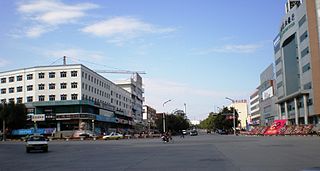
Tumxuk is a county-level city in the western part of Xinjiang, China. The eastern part of Tumxuk is surrounded by Maralbexi County, Kashgar Prefecture. The smaller western part is near Kashgar.

<span class="mw-page-title-main">Bayingolin Mongol Autonomous Prefecture</span> Autonomous prefecture in Xinjiang, China

Bayingolin Mongol Autonomous Prefecture is an autonomous prefecture in the southeastern Xinjiang, China. It borders Gansu to the east, Qinghai to the southeast and the Tibet Autonomous Region to the south. It is the largest prefecture-level division nationally, with an area of 471,480 km2 (182,040 sq mi), which is even larger than its neighboring province of Gansu. The prefectural capital is Korla. Despite being designated an autonomous area for Mongols in China, only about four percent of Bayingolin's population is Mongol.

<span class="mw-page-title-main">Artux</span> County-level city in Xinjiang, China

Artux or Artush or Atush is a county-level city and the capital of Kizilsu Kyrgyz Autonomous Prefecture in Xinjiang, China. The government seat is in Guangming Road Subdistrict. As of 2018, it has a population of 285,507 people, 81.4 per cent of whom are Uyghurs.

<span class="mw-page-title-main">Qinggil County</span> County in Xinjiang, China

Qinggil County (Uyghur), also Chinggil County, Qinghe County, is a county of Altay Prefecture in northeastern Xinjiang, China, bordering Bayan-Ölgii Province and Khovd Province in Mongolia to the east. It has an area of 15,722 km2 (6,070 sq mi) with a population of 60,000. Qinghe was the site of a meteorite impact in 1898 and a Mongolian–Chinese border clash in the spring of 1944.

<span class="mw-page-title-main">Uqturpan County</span> County in Xinjiang, China

Uqturpan County or Uchturpan County, also Wushi County, is a county in the Xinjiang Uyghur Autonomous Region under the administration of Aksu Prefecture and shares an approximately 150 km (93 mi) long border with Kyrgyzstan's Issyk-Kul Region. The county is bordered to the northeast by Onsu County (Wensu), to the southeast by Aksu city, to the west by Akqi County in Kizilsu Kyrgyz Autonomous Prefecture and to the south by Kalpin County (Keping). It has an area of 9,012 square kilometres (3,480 sq mi) and as of the 2002 census a population of 180,000.

<span class="mw-page-title-main">Xinhe County, Xinjiang</span> County in Xinjiang, China

Xinhe County as the official romanized name, also formerly known as its Uyghur name Toksu County, is a county in Aksu Prefecture, Xinjiang Uyghur Autonomous Region, China.

<span class="mw-page-title-main">Kalpin County</span> County in Xinjiang, China

Kalpin County is a county in the Xinjiang Uyghur Autonomous Region and is under the administration of the Aksu Prefecture. The overwhelmingly Uyghur population of the county lives on oases at the base of the Tian Shan mountains and on the edge of the Taklamakan Desert.

<span class="mw-page-title-main">Kuqa, Xinjiang</span> County-level city in Xinjiang, China

Kuqa is a county-level city in Aksu Prefecture, Xinjiang Uyghur Autonomous Region, China. Other names and variants of spelling of Kuqa are Kocha, Kuchu, Kuchar, Kuchi, Kuchel, K'u-ch'e-chen, K'u-ch'e-hsien, Kuga, Kucha and K'u-ch'e. It was once the homeland of the ancient Buddhist Kingdom of Kucha.

<span class="mw-page-title-main">Awat County</span> County in Xinjiang, China

Awat County is a county in Aksu Prefecture, Xinjiang Uyghur Autonomous Region, China. Awat County is located on the southern foot of the Tian Shan mountain range and on the northern edge of the Taklamakan Desert.

<span class="mw-page-title-main">Onsu County</span> County in Xinjiang, China

Onsu County and from Mandarin Chinese Wensu County, is a county in the Xinjiang Uyghur Autonomous Region and is under the administration of the Aksu Prefecture, bordering Kyrgyzstan's Issyk-Kul Region to the northwest. It contains an area of 14,309 km2 (5,525 sq mi).

<span class="mw-page-title-main">Maralbexi County</span> County in Xinjiang, China

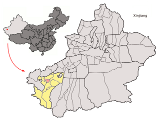
Maralbexi County, Bachu County, and Chinese: 巴尔楚克县) the former long Chinese name as well, is located in the southwest of the Xinjiang Uyghur Autonomous Region, China. The county is under the administration of the Kashgar Prefecture. It has an area of 18,491 km2 (7,139 sq mi), and surrounds, but does not administer, the sub-prefecture-level city of Tumxuk. According to the 2002 census, it has a population of 380,000.

<span class="mw-page-title-main">Yopurga County</span> County in Xinjiang, China

Yopurga County is a county in northern Kashgar Prefecture, Xinjiang Uyghur Autonomous Region. More than 96% of the residents of the county are Uyghurs and live around oases at the western edge of the desolate Taklamakan Desert. The county is bordered to the north by Jiashi County, to the east by Maralbexi County, to the west by Shule County, to the southwest by Yengisar County and to the south by Yarkant County.

<span class="mw-page-title-main">Yuli County</span> County in Xinjiang, China

Yuli County as the official Romanized name, also transliterated from Mongolian as Lopnur County, is a county in the Xinjiang Uyghur Autonomous Region and is under the administration of the Bayin'gholin Mongol Autonomous Prefecture. It contains an area of 59,399 km2 (22,934 sq mi). According to the 2002 census, it has a population of 100,000.

<span class="mw-page-title-main">Ruoqiang County</span> County in Xinjiang, China

Ruoqiang County as the official romanized name, also transliterated from Uyghur as Qakilik County, is a county in the Xinjiang Uyghur Autonomous Region, China under the administration of the Bayingolin Mongol Autonomous Prefecture. It covers an area of 198,318 square kilometres (76,571 sq mi), making it the largest county-level division in the country.

<span class="mw-page-title-main">Hotan County</span> County in Xinjiang, China

Hotan County is a county in the southwest of the Xinjiang Uyghur Autonomous Region and is under the administration of the Hotan Prefecture. Almost all the residents of the county are Uyghurs and live around oases situated between the desolate Taklamakan Desert and Kunlun Mountains. Hotan County is the southernmost county-level division of Xinjiang. The county borders Karakax/Moyu County to the northwest, Hotan City and Lop County to the northeast, Qira County to the east, Pishan County to the west, and Rutog County, Tibet to the southeast. Hotan County administers most of Aksai Chin, an area disputed between China and India. The Line of Actual Control divides the India-controlled part of Ladakh union territory from the Aksai Chin area administered as part of southwest Hotan County.

<span class="mw-page-title-main">Toksun County</span> County in Xinjiang, China

Toksun County is a county in Turpan, Xinjiang Uyghur Autonomous Region, China.

<span class="mw-page-title-main">Hotan Prefecture</span> Prefecture in Xinjiang, Peoples Republic of China

Hotan Prefecture is located in the Tarim Basin region of southwestern Xinjiang, China, bordering the Tibet Autonomous Region to the south and Union Territory of Ladakh and Gilgit-Baltistan to the west. The vast majority of the Aksai Chin region which is disputed between China and India is administered as part of Hotan Prefecture. The seat of Hotan Prefecture is Hotan and its largest county by population is Karakax County. The vast majority of the residents of the prefecture are Muslim Uyghurs and live around oases situated between the desolate Taklamakan Desert and Kunlun Mountains.

References

  1. Xinjiang: Prefectures, Cities, Districts and Counties
  2. The official spelling according to Zhōngguó dìmínglù, 中国地名录 (Beijing, SinoMaps Press 中国地图出版社 1997); ISBN   7-5031-1718-4
  3. The official spelling is Aral, according to the Zhōngguó dìmínglù, 中国地名录 (Beijing, SinoMaps Press 1997); ISBN   7-5031-1718-4; p. 1, 299.
  4. "Free Uighur Dictionary". Archived from the original on 2015-10-18. Retrieved 2014-05-03.
  5. Sharma, Yojana (18 July 2014). "Government rushes through Kashgar university plan". University World News. Retrieved 14 January 2020.
  6. Gulchehre Hoja, Joshua Lipes (2020-04-13). "Subsidies For Han Settlers 'Engineering Demographics' in Uyghur-Majority Southern Xinjiang". Radio Free Asia . Translated by Elise Anderson. Archived from the original on 14 April 2020. Retrieved 13 November 2020.
  7. 阿瓦提县历史沿革 [Awat County Historical Development] (in Simplified Chinese). XZQH.org. 30 January 2015. Retrieved 14 May 2019. 2013年1月23日,自治区政府(新政函[2013]17号)批复同意将阿瓦提县474.208平方千米区域划归阿拉尔市管辖。
  8. 阿克苏市历史沿革 [Aksu City Historical Development] (in Simplified Chinese). XZQH.org. 30 January 2015. Retrieved 18 May 2019.
  9. 3-7 各地、州、市、县(市)分民族人口数 (in Simplified Chinese). شىنجاڭ ئۇيغۇر ئاپتونوم رايونى新疆维吾尔自治区统计局 Statistic Bureau of Xinjiang Uygur Autonomous Region. 15 March 2017. Archived from the original on 11 October 2017. Retrieved 3 September 2017.
  10. 中国气象数据网 – WeatherBk Data (in Simplified Chinese). China Meteorological Administration . Retrieved 10 October 2023.
  11. 中国气象数据网 (in Simplified Chinese). China Meteorological Administration . Retrieved 10 October 2023.