Changjiang Li Autonomous County

Last updated
Changjiang
昌江县
Ch'ang-chiang, Cheongkong
昌江黎族自治县
Changjiang Li Autonomous County
China Hainan location map.svg
Red pog.svg
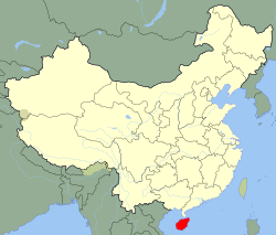
Changjiang
Location in Hainan
Coordinates: 19°21′58″N109°2′32″E / 19.36611°N 109.04222°E / 19.36611; 109.04222
Country People's Republic of China
Province Hainan
Area
  Total1,617 km2 (624 sq mi)
Population
 (1999)
  Total225,131
  Density140/km2 (360/sq mi)
Time zone UTC+8 (China standard time)

Changjiang Li Autonomous County (formerly known by its Cantonese romanization name Cheongkong) is an autonomous county in Hainan, China. It is one of six counties of Hainan. Its postal code is 572700, and in 1999 its population was 225,131 people, largely made up of the Li people.

Contents

The county seat is in Shilu Town. Shilu is known for a major iron ore deposit (the Shilu Iron Ore Mine, 石碌铁矿), which has been worked since the Japanese occupation of the island in the early 1940s. [1]

Climate

Changjiang has a tropical savanna climate (Aw). The monthly high temperature exceeds 25 °C (77 °F). The rainy season is from May to October, and the monthly precipitation exceeds 170mm (6.7inches). The Bawangling National Nature Reserve within the territory is home to endangered Hainan gibbons.

Climate data for Changjiang (1991−2020 normals, extremes 1981–2010)
MonthJanFebMarAprMayJunJulAugSepOctNovDecYear
Record high °C (°F)34.9
(94.8)
37.4
(99.3)
39.9
(103.8)
40.2
(104.4)
39.1
(102.4)
38.5
(101.3)
38.8
(101.8)
39.0
(102.2)
37.0
(98.6)
35.2
(95.4)
34.2
(93.6)
32.9
(91.2)
40.2
(104.4)
Mean daily maximum °C (°F)25.3
(77.5)
26.9
(80.4)
30.0
(86.0)
32.8
(91.0)
34.1
(93.4)
34.5
(94.1)
33.9
(93.0)
33.0
(91.4)
31.9
(89.4)
30.3
(86.5)
28.2
(82.8)
25.3
(77.5)
30.5
(86.9)
Daily mean °C (°F)19.6
(67.3)
20.9
(69.6)
23.6
(74.5)
26.8
(80.2)
28.6
(83.5)
29.6
(85.3)
28.9
(84.0)
28.1
(82.6)
27.0
(80.6)
25.7
(78.3)
23.5
(74.3)
20.5
(68.9)
25.2
(77.4)
Mean daily minimum °C (°F)16.1
(61.0)
17.2
(63.0)
19.7
(67.5)
22.8
(73.0)
24.9
(76.8)
26.1
(79.0)
25.6
(78.1)
25.0
(77.0)
24.0
(75.2)
22.6
(72.7)
20.4
(68.7)
17.5
(63.5)
21.8
(71.3)
Record low °C (°F)7.2
(45.0)
8.5
(47.3)
6.5
(43.7)
14.6
(58.3)
17.6
(63.7)
19.6
(67.3)
20.4
(68.7)
20.2
(68.4)
19.0
(66.2)
14.1
(57.4)
10.8
(51.4)
5.4
(41.7)
5.4
(41.7)
Average precipitation mm (inches)7.5
(0.30)
10.8
(0.43)
27.7
(1.09)
73.1
(2.88)
171.1
(6.74)
180.9
(7.12)
295.6
(11.64)
407.6
(16.05)
330.7
(13.02)
175.0
(6.89)
52.1
(2.05)
16.2
(0.64)
1,748.3
(68.85)
Average precipitation days (≥ 0.1 mm)3.13.05.07.312.610.514.817.418.512.56.03.7114.4
Average relative humidity (%)75757473727174788177757475
Mean monthly sunshine hours 162.4158.2179.6201.9223.6219.7214.4198.4166.3185.0174.9152.72,237.1
Percent possible sunshine 47494853555553514651524550
Source: China Meteorological Administration [2] [3]

See also

Related Research Articles

<span class="mw-page-title-main">Cangzhou</span> Prefecture-level city in Hebei, Peoples Republic of China

Cangzhou is a prefecture-level city in eastern Hebei province, People's Republic of China. At the 2020 census, Cangzhou's built-up area made of Yunhe, Xinhua districts and Cang County largely being conurbated had a population of 1,421,843 inhabitants, while the prefecture-level administrative unit in total has a population of 7,300,783. It lies approximately 90 kilometres (56 mi) from the major port city of Tianjin, and 180 km (110 mi) from Beijing.

<span class="mw-page-title-main">Baise</span> Prefecture-level city in Guangxi, Peoples Republic of China

Baise, or Bose, is the westernmost prefecture-level city of Guangxi, China bordering Vietnam as well as the provinces of Guizhou and Yunnan. The city has a population of 4.3 million, of which 1.4 million live in the urban area.

<span class="mw-page-title-main">Sunan Yugur Autonomous County</span> Autonomous county in Gansu, China

Sunan Yugur Autonomous County is an autonomous county under the administration of the prefecture-level city of Zhangye, Gansu Province, China, bordering Qinghai province to the south. It is home to the majority of the Yugur ethnic group. The seat of government is in the town of Hongwansi (红湾寺镇).

<span class="mw-page-title-main">Lingao County</span> County in Hainan, Peoples Republic of China

Língāo County is an administrative district in Hainan province, China. It is one of the 4 counties of Hainan. Its postal code is 571800, and in 1999, its population was 399,057 people.

<span class="mw-page-title-main">Chengmai County</span> County in Hainan, Peoples Republic of China

Chengmai County is a county in Hainan, China. It is one of four counties of Hainan. Its postal code is 571900. In 2002, its population was 490,800.

<span class="mw-page-title-main">Ding'an County</span> County in Hainan, Peoples Republic of China

Dìng'ān is an administrative district in Hainan, People's Republic of China. It is one of 4 counties of Hainan. In 1999, its population was 304,522 people.

<span class="mw-page-title-main">Tunchang County</span> County in Hainan, Peoples Republic of China

Tunchang County is a county of Hainan Province, People's Republic of China. Its postal code is 571600, and in 1999 its population was 250,059 people. The administrative seat lies at Tuncheng.

<span class="mw-page-title-main">Baisha Li Autonomous County</span> Autonomous County in Hainan, Peoples Republic of China

Baisha Li Autonomous County, p Báishā Lízú Zìzhìxiàn) is one of 6 autonomous counties of Hainan, China. In 1999 its population was 176,377 people, largely made up of the Li people.

<span class="mw-page-title-main">Qiongzhong Li and Miao Autonomous County</span> Autonomous County in Hainan, Peoples Republic of China

Qiongzhong Li and Miao Autonomous County is an autonomous county in Hainan, China. It is one of 6 autonomous counties of the upper highlands of Hainan. Its postal code is 572900, and in 1999, its population was 196,581 people, largely made up of the Li people and the Miao people.

<span class="mw-page-title-main">Lingshui Li Autonomous County</span> Autonomous County in Hainan, Peoples Republic of China

Língshuǐ Li Autonomous County is an autonomous county in Hainan, China. It is one of the six autonomous counties of Hainan with a postal code of 572400, and in 1999 a population of 318,691, largely made up of the Li people. Notably the beautiful Niuling (牛岭) mountain delimits the tropical area of the county. A well-known natural sight, part of the Chinese Riviera is Xiangshuiwan or Perfume bay (香水湾). Monkey Island, a popular tourist destination located in Lingshui County, is a state-protected nature reserve for macaques. Lingshui is also home to the military base where a U.S. airplane crew were held during the Hainan Island incident in 2001. In September 2010, officials signed and scheduled the construction of the largest sea world theme park in Asia. The Lingshui Li'an Harbor Ocean Theme Park signing ceremony took place at the Narada Resort in Perfume Bay and the opening is planned for 2013.

<span class="mw-page-title-main">Baoting Li and Miao Autonomous County</span> Autonomous County in Hainan, Peoples Republic of China

Bǎotíng Li and Miao Autonomous County is an autonomous county in Hainan, China. One of the six autonomous counties on the island, its postal code is 572300. Baoting spans an area of 1,153.24 square kilometres (445.27 sq mi), and has a population of about 168,000 as of 2020.

Ledong Li Autonomous County is an autonomous county in Hainan province, China. It is one of six autonomous counties of Hainan. Its postal code is 572500, and in 1999, its population was 468,834 people, largely made up of the Li people.

<span class="mw-page-title-main">Qingyuan Manchu Autonomous County</span> Autonomous county in Liaoning, China

Qingyuan Manchu Autonomous County, or simply Qingyuan County (清原县) is one of the three counties under the administration of the prefecture-level city of Fushun, in the east of Liaoning, China, and is also one of the 11 Manchu autonomous counties and one of 117 autonomous counties nationally. It has a population of about 340,000, covering an area of 3,921 square kilometres (1,514 sq mi).

<span class="mw-page-title-main">Fujin City</span> County-level city in Heilongjiang, Peoples Republic of China

Fujin is a county-level city in the east of Heilongjiang province, People's Republic of China. It is under the jurisdiction of the prefecture-level city of Jiamusi.

<span class="mw-page-title-main">Tongde County</span> County in Qinghai, China

Tongde County is a county of Qinghai province, China. It is under the administration of Hainan Tibetan Autonomous Prefecture.

East Ujimqin Banner is a banner in the northeast of the Inner Mongolia, China. It is under the administration of Xilin Gol League.

Basuo is a town on the west coast of Hainan Province, China. It is the administrative center of the county-level city of Dongfang; in other words, Basuo is Dongfang's main urban area, and Basuo's location is usually shown on less-detailed maps by a circle labeled "Dongfang".

<span class="mw-page-title-main">Hainan western ring railway</span> Railway System

The Hainan western ring railway is a standard-gauge railway running along the coast of the western half of Hainan Island in South China. It connects the provincial capital Haikou on the island's north coast with Sanya, the major city on Hainan's south coast. The rail line is 363.8 km long; its terminals are Haikou railway station and Sanya railway station. Cargo trains enter this railway from Zhanjiang, Guangdong at the South Port of the Guangdong–Hainan Railway.

Shilu Town is the county seat of Changjiang Li Autonomous County in China's Hainan Island. It is known for a major iron ore deposit, which has been worked since the Japanese occupation of the island in the early 1940s.

References

Citations

  1. Vogel, Ezra F. (1990), One Step Ahead in China: Guandong Under Reform, Harvard University Press, p. 277, ISBN   0674639111
  2. 1991-2020 normals "Climate averages from 1991 to 2020". China Meteorological Administration . Archived from the original on 2023-04-17.
  3. 1981-2010 extremes 中国气象数据网 – WeatherBk Data (in Simplified Chinese). China Meteorological Administration . Retrieved 14 April 2023.

Sources