Qionghai

Last updated
Qionghai
琼海市
Qionghai 03.jpg
Hainan subdivisions - Qionghai.png
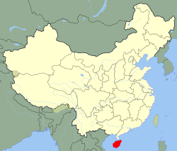
Map showing entire Qionghai area within Hainan province
Coordinates: 19°14′35″N110°27′51″E / 19.24306°N 110.46417°E / 19.24306; 110.46417
CountryPeople's Republic of China
Province Hainan
Township-level divisions12 towns
Municipal seat Jiaji (嘉积镇)
Area
  Total1,692 km2 (653 sq mi)
Elevation
22 m (73 ft)
Population
 (2010)
483,217
Time zone UTC+8 (China Standard)
Postal code
571400
Area code 0898
Licence plates 琼C
Website qionghai.hainan.gov.cn

Qionghai is one of the seven county-level cities of Hainan province, China. Although called a "city", Qionghai refers to a large land area in Hainan - an area which was once a county. Within this area is the main city, Qionghai City. It is located in the east of the island at the mouth of the Wanquan River, 86 kilometres (53 mi) from the provincial capital of Haikou. It has an area of 1,692 square kilometres (653 sq mi) and in 2010, it had a population of 483,217 people.

Contents

The seat of government is at Jiaji (simplified Chinese:嘉积镇; traditional Chinese:嘉積鎮; pinyin:Jiājī Zhèn), locally referred to as Kachek city. Bo'ao, seat of the Boao Forum for Asia, belongs to Qionghai. [1] :101

The former counties of Qiongdong (postal: Kiungtung) and Lehui (樂㑹, postal: Lokwei) are now part of Qionghai City.

Climate

Qionghai has a tropical monsoon climate (Köppen Am). [2] Monsoonal influences are strong, with a relatively lengthy wet season and a pronounced dry season (January to March). Rainfall is heaviest and most frequent from August to October, when typhoons may strike, and is otherwise still common throughout the year, averaging an annual total of 2,100 mm (83 in); there are 9.3 days with 50 mm (1.97 in) or more of rain. Humidity is consistently very high, with an average relative humidity of 85.8%. With monthly percent possible sunshine ranging from 31% in February to 62% in July, the city receives 1913 hours of bright sunshine annually; the city receives about only a third of possible sunshine from December thru February, while May thru July is the sunniest time of year.

Climate data for Qionghai (1991–2020 normals, extremes 1981–2010)
MonthJanFebMarAprMayJunJulAugSepOctNovDecYear
Record high °C (°F)31.2
(88.2)
34.7
(94.5)
33.9
(93.0)
36.8
(98.2)
38.8
(101.8)
39.2
(102.6)
39.2
(102.6)
37.2
(99.0)
36.9
(98.4)
34.8
(94.6)
33.5
(92.3)
30.4
(86.7)
39.2
(102.6)
Mean daily maximum °C (°F)22.9
(73.2)
24.3
(75.7)
27.2
(81.0)
30.2
(86.4)
32.7
(90.9)
33.6
(92.5)
33.4
(92.1)
33.1
(91.6)
31.8
(89.2)
29.5
(85.1)
26.9
(80.4)
23.7
(74.7)
29.1
(84.4)
Daily mean °C (°F)19.0
(66.2)
20.4
(68.7)
23.1
(73.6)
26.0
(78.8)
28.0
(82.4)
29.0
(84.2)
28.8
(83.8)
28.3
(82.9)
27.4
(81.3)
25.7
(78.3)
23.3
(73.9)
20.1
(68.2)
24.9
(76.9)
Mean daily minimum °C (°F)16.6
(61.9)
17.9
(64.2)
20.6
(69.1)
23.3
(73.9)
25.0
(77.0)
26.0
(78.8)
25.8
(78.4)
25.3
(77.5)
24.7
(76.5)
23.0
(73.4)
20.9
(69.6)
17.8
(64.0)
22.2
(72.0)
Record low °C (°F)7.8
(46.0)
8.0
(46.4)
6.3
(43.3)
14.6
(58.3)
15.7
(60.3)
21.0
(69.8)
22.2
(72.0)
21.5
(70.7)
18.8
(65.8)
13.9
(57.0)
10.1
(50.2)
6.3
(43.3)
6.3
(43.3)
Average precipitation mm (inches)40.4
(1.59)
49.3
(1.94)
62.9
(2.48)
119.1
(4.69)
216.6
(8.53)
174.0
(6.85)
188.5
(7.42)
282.3
(11.11)
374.7
(14.75)
419.0
(16.50)
122.3
(4.81)
86.8
(3.42)
2,135.9
(84.09)
Average precipitation days (≥ 0.1 mm)10.710.210.410.614.213.513.717.617.115.512.611.4157.5
Average relative humidity (%)85868583828181838482828283
Mean monthly sunshine hours 95.8101.9143.0174.9214.7220.6234.1212.8166.7150.8112.485.91,913.6
Percent possible sunshine 28313846535658544642342543
Source: China Meteorological Administration [3] [4] [5]

Administrative divisions

Qionghai is divided into 12 towns: [6]

Other

Qionghai Police Station HN QH Qionghai County police station.jpg
Qionghai Police Station

The most famous dish of Qionghai is called Kazek Duck.

Qionghai is served by Qionghai Bo'ao Airport.

Qionghai is also well known for being the home of the Red Detachment of Women from the revolutionary model opera which was also adapted into film. [1] :102 The Red Detachment of Women Memorial Park in Qionghai was developed in 1998. [1] :102 The park includes revolutionary-themed sculpture, a museum, coconut groves, and live performances. [1] :102 In 2005, it was recognized as a National Classic Red Tourism Attraction by China National Tourism Administration and other government bodies. [1] :102

Notable people

See also

Related Research Articles

<span class="mw-page-title-main">Dongfang, Hainan</span> County-level & Sub-prefectural city in Hainan, Peoples Republic of China

Dongfang is one of the seven county-level cities of Hainan province, China. Although called a "city", Dongfang refers to a large land area in Hainan - an area which was once a county. Within this area is the main city, Dongfang City. It is located on the western coast of Hainan Island facing Vietnam across the Gulf of Tonkin, and in 2004 had a population of 435,000.

<span class="mw-page-title-main">Huoshan County</span> County in Anhui, Peoples Republic of China

Huoshan is a county of western Anhui province, People's Republic of China, and is under the jurisdiction of Lu'an City. It has a population of 370,000 and an area of 2,042 square kilometres (788 sq mi). The government of Huoshan County is located in Hengshan Town.

<span class="mw-page-title-main">Zhangwu County</span> County in Liaoning, Peoples Republic of China

Zhangwu County is a county in the north of Liaoning province, China. It is under the administration of Fuxin City, the centre of which lies 82 kilometres (51 mi) to the southwest, with a population of 410,000 residing in an area of 3,635 km2 (1,403 sq mi). It is served by G25 Changchun–Shenzhen Expressway, G2511 Xinmin–Lubei Expressway, and China National Highways 101 and 304.

<span class="mw-page-title-main">Linjiang</span> County-level city in Jilin, Peoples Republic of China

Linjiang is a county-level city in Baishan, Jilin, China. It is located to the east of Tonghua, and borders North Korea along the Yalu River.

<span class="mw-page-title-main">Huailai County</span> County in Hebei, Peoples Republic of China

Huailai is a county in northwestern Hebei province, People's Republic of China, under the administration of the prefecture-level city of Zhangjiakou.

Anda is a county-level city in western Heilongjiang province, People's Republic of China, located on the Harbin-Manzhouli Railway about 30 kilometres (19 mi) southeast of Daqing and 110 km (68 mi) northwest of Harbin, capital of Heilongjiang, and is under the administration of Suihua City. Home to China's forage and dairy industries, more than 1,814 km2 (700 sq mi) out of Anda's 3,586 km2 (1,385 sq mi) total area is made up of grasslands.

<span class="mw-page-title-main">Tonghe County</span> County in Heilongjiang, Peoples Republic of China

Tonghe County is under the administration of Harbin, the capital of Heilongjiang province, People's Republic of China, located on the northern (left) bank of the Songhua River. It is 161 kilometres (100 mi) to the east of central Harbin, bordering Yilan County to the east, Fangzheng County to the south, Mulan County to the west, as well as the prefecture-level city of Yichun to the north.

<span class="mw-page-title-main">Tongde County</span> County in Qinghai, China

Tongde County is a county of Qinghai province, China. It is under the administration of Hainan Tibetan Autonomous Prefecture.

<span class="mw-page-title-main">Darlag County</span> County in Qinghai, China

Darlag County is a county of southeastern Qinghai province, China, bordering Sichuan to the south and west. It is under the administration of Golog Tibetan Autonomous Prefecture. The county seat is in the Town of Gyümai.

<span class="mw-page-title-main">Madoi County</span> County in Qinghai, China

Madoi County is a county of Golog Tibetan Autonomous Prefecture, in southeast-central Qinghai province, bordering Sichuan to the south. Its area is about 25,000 km2 (9,700 sq mi), and with an average elevation of 4,300 m (14,000 ft) it is the highest Chinese county by average elevation. In Madoi County is the upper stream of the Yellow River which flows to Ngoring and Gyaring lake.

Huimin County is a county of northwestern Shandong province, People's Republic of China. It is under the administration of Binzhou City.

<span class="mw-page-title-main">Urad Middle Banner</span> Banner in Inner Mongolia, China

Urad Middle Banner is a banner of Inner Mongolia, China. It is located in the west of the region, and administratively is part of Bayan Nur City. It has a total area of 22,606 square kilometres (8,728 sq mi) and in 2020 had a population of 112,159.

<span class="mw-page-title-main">Guiping</span> County-level city in Guangxi, China

Guiping is a county-level city in eastern Guangxi, China. It is under the administration of Guigang City, located at the confluence of the Qian and Yu rivers, which are the Xi River's primary north and south tributaries, respectively.

Laoting County, often mispronounced as Leting County in accordance with the alternative frequently used Mandarin pronunciation, is a county in the northeast of Hebei province, People's Republic of China, facing the Bohai Sea to the east and south. It is under the administration of Tangshan City.

<span class="mw-page-title-main">Qian Gorlos Mongol Autonomous County</span> Autonomous county in Jilin, China

Qian Gorlos Mongolian Autonomous County, or simply Qian Gorlos County, commonly abbreviated as Qianguo County, is a county of northwestern Jilin province, China. It is under the administration of Songyuan City. Gorlos Mongols live here. Formerly known as Gorlos Front Banner (郭尔罗斯前旗).

<span class="mw-page-title-main">Jianping County</span> County in Liaoning, Peoples Republic of China

Jianping is a county in the west of Liaoning province, China, bordering Inner Mongolia to the north, west, and northeast. It is under the administration of Chaoyang City, the urban centre of which is more than 65 km (40 mi) to the east. The population is approximately 580,000.

<span class="mw-page-title-main">Yuanping</span> County-level city in Shanxi, Peoples Republic of China

Yuanping is a county-level city under the administration of the prefecture-level city of Xinzhou, in north-central Shanxi Province, China.

<span class="mw-page-title-main">Linxi County, Inner Mongolia</span> County in Inner Mongolia, China

Linxi County is a county of eastern Inner Mongolia, China. It is under the administration of Chifeng City, 165 kilometres (103 mi) to the south-southeast.

Abag Banner is a county of Inner Mongolia, China. It is under the administration of Xilingol League. Abag Mongols live here. The local dialect has variously been classified as Chakhar or Khalkha.

Tulihe is a town under the administration of Yakeshi City in far northeastern Inner Mongolia, China, located 150 kilometres (93 mi) northeast of Yakeshi and 35 km (22 mi) south-southeast of Genhe. As of 2011, it has two residential communities (社区) under its administration.

References

  1. 1 2 3 4 5 Lin, Chunfeng (2023). Red Tourism in China: Commodification of Propaganda. Routledge. ISBN   9781032139609.
  2. Peel, M. C. and Finlayson, B. L. and McMahon, T. A. (2007). Updated Asian Map of the Köppen climate classification system. Hydrol. Earth Syst. Sci. 11: 1633-1644.
  3. 中国气象数据网 – WeatherBk Data (in Simplified Chinese). China Meteorological Administration . Retrieved 17 June 2023.
  4. 中国气象数据网 (in Simplified Chinese). China Meteorological Administration . Retrieved 17 June 2023.
  5. 中国地面国际交换站气候标准值月值数据集(1971-2000年). China Meteorological Administration. Archived from the original on 2013-09-21. Retrieved 2010-05-25.
  6. 2011年统计用区划代码和城乡划分代码:琼海市 (in Chinese (China)). National Bureau of Statistics of the People's Republic of China. Archived from the original on 2012-07-03. Retrieved 2013-02-10.