This article needs additional citations for verification .(January 2013) |
Golmud 格尔木市 · ᠭᠣᠯᠮᠣᠣᠠ ᠬᠣᠲᠠ · ན་གོར་མོ་གྲོང་ཁྱེར། Golmo | |
---|---|
![]() | |
![]() Location of Golmud City (red) in Haixi Prefecture (yellow) and Qinghai | |
Coordinates(Golmud government): 36°24′26″N94°55′42″E / 36.4072°N 94.9283°E | |
Country | China |
Province | Qinghai |
Autonomous prefecture | Haixi |
Municipal seat | Kunlun Road Subdistrict |
Area | |
119,165 km2 (46,010 sq mi) | |
• Urban | 72 km2 (28 sq mi) |
Elevation | 2,809 m (9,216 ft) |
Population (2020) [1] | |
221,863 | |
• Density | 1.9/km2 (4.8/sq mi) |
• Urban | 197,153 |
• Urban density | 2,700/km2 (7,100/sq mi) |
Time zone | UTC+8 (China Standard) |
Website | www |
Golmud | |||||||||
---|---|---|---|---|---|---|---|---|---|
Chinese name | |||||||||
Simplified Chinese | 格尔木 | ||||||||
Traditional Chinese | 格爾木 | ||||||||
Postal | Golmot | ||||||||
Literal meaning | Rivers (in Mongolian) | ||||||||
| |||||||||
Tibetan name | |||||||||
Tibetan | ན་གོར་མོ། | ||||||||
| |||||||||
Mongolian name | |||||||||
Mongolian script | ᠭᠣᠯᠮᠤᠳ |
Golmud, also known by various other romanizations,is a county-level city in the Haixi Mongol and Tibetan Autonomous Prefecture of Qinghai Province,China. It is now the second-largest city in Qinghai and the third largest in the Tibetan Plateau (after Xining and Lhasa). The population in 2020 is 221,863. [2] [3]
Golmud is a romanization of a Mongolian word meaning "rivers". Ge'ermu is the pinyin romanization of the Mandarin pronunciation of the same name's transcription into Chinese characters;it is sometimes misspelled Geermu. Ko-erh-mu was the same name romanized using the Wade–Giles system;Golmot was the romanization used by the Chinese Postal Map. [4] The Wylie romanization of the Tibetan form of the name is Nagormo.
Golmud is a rather young city. It was first established in 1954 when the Transportation regiments of Qinghai-Tibet Corps set up a food distribution base,staffed by 10 people,at the current location,and in May of that year,construction on the Qinghai-Tibet Highway commenced. [5] [6] Scientific exploration of the mineral resources of Qarhan were undertaken in the 1950s,leading to the discovery of the area's potash and gas fields. Systematic surveying was undertaken in the 1960s and 1970s,with the railway permitting industrial exploitation from the 1980s. The first oil pipeline [7] and potassium fertilizer factory were opened in 1989. The 28 km2 (11 sq mi) Golmud Kunlun Economic Development Zone was opened in 1992. In 2004,a second pipeline arrived. [7] In the 2010s,an influx of further investment followed realization of the importance of the Sanhu's supplies of lithium and rare earths for modern personal electronics and electric cars.[ citation needed ] In 2016,over 85% of goods movement with Tibet passed through Golmud. [5]
Golmud is divided into 5 subdistricts,2 towns,2 townships: [8] [9] [10]
Name | Simplified Chinese | Hanyu Pinyin | Tibetan | Wylie | Mongolian (traditional script) | Mongolian (Cyrillic) | Administrative division code |
---|---|---|---|---|---|---|---|
Subdistricts | |||||||
Kunlun Road Subdistrict | 昆仑路街道 | KūnlúnlùJiēdào | ཁུ་ནུ་སྲང་ལམ། | khu nu srang lam | ᠺᠦᠨᠯᠦᠨᠵᠠᠮ ᠤᠨᠵᠡᠭᠡᠯᠢᠭᠤᠳᠤᠮᠵᠢ | Кунлүнзамынзээлгудамж | 632801001 |
Huanghe Road Subdistrict | 黄河路街道 | HuánghélùJiēdào | རྨ་ཆུ་ལམ་སྲང་ལམ། | rma chu lam srang lam | ᠬᠤᠸᠠᠩᠾᠧᠵᠠᠮ ᠤᠨᠵᠡᠭᠡᠯᠢᠭᠤᠳᠤᠮᠵᠢ | Хуангезамынзээлгудамж | 632801002 |
Jinfeng Road Subdistrict | 金峰路街道 | JīnfēnglùJiēdào | གསེར་རིའི་སྲང་ལམ། | gser ri'i srang lam | ᠵᠢᠨᠹᠧᠩᠵᠠᠮ ᠤᠨᠵᠡᠭᠡᠯᠢᠭᠤᠳᠤᠮᠵᠢ | Гийнфензамынзээлгудамж | 632801003 |
Hexi Subdistrict | 河西街道 | HéxīJiēdào | ཆུའི་རུབ་སྲང་ལམ། | chu'i rub srang lam | ᠭᠣᠣᠯ ᠤᠨᠪᠠᠷᠠᠭᠤᠨᠳᠠᠬᠢᠵᠡᠭᠡᠯᠢᠭᠤᠳᠤᠮᠵᠢ | Голынбаруунтахзээлгудамж | 632801004 |
Xizang Road Subdistrict | 西藏路街道 | XīzànglùJiēdào | བོད་ལྗོངས་ལམ་སྲང་ལམ། | bod ljongs lam srang lam | ᠪᠠᠷᠠᠭᠤᠨᠲᠥᠪᠡᠳᠵᠠᠮᠳ᠋ᠠᠬᠢᠵᠡᠭᠡᠯᠢᠭᠤᠳᠤᠮᠵᠢ | Баруунтөвдзамдаахьзээлгудамж | 632801005 |
Towns | |||||||
Golmud Town | 郭勒木德镇 | GuōlèmùdéZhèn | ཀོལ་མོ་གྲོང་རྡལ། | kol mo grong rdal | ᠭᠣᠣᠯᠮᠤᠳᠪᠠᠯᠭᠠᠰᠤᠨ | Голмдбалгас | 632801100 |
Dangla Town | 唐古拉镇 | TánggǔlāZhèn | ལྡང་ལ་གྲོང་རྡལ། | ldang la grong rdal | 632801101 | ||
Townships | |||||||
Gêlêg Qênboi Township | 大格勒乡 | DàgélèXiāng | དགེ་ལེགས་ཆེན་པོའི་ཡུལ་ཚོ། | dge legs chen po'i yul tsho | ᠳᠠᠭᠤᠷᠰᠤᠮᠤᠨ | Дагуурсуман | 632801200 |
Urt Moron Township | 乌图美仁乡 | Wūtúměirén Xiāng | བུ་ཐུར་མེད་རིན་ཡུལ་ཚོ། | bu thur med rin yul tsho | ᠤᠷᠲᠤᠮᠥ᠋ᠷᠡᠨᠰᠤᠮᠤᠨ | Уртмрансуман | 632801201 |
Others:
In 2017,the population of the total area of Golmud was approximately 240,494.[ citation needed ] A 2018 publication by the National Ethnic Affairs Commission reported that ethnic Han Chinese comprise 69.82% of the city's population,and minority ethnic groups comprise 30.18%. [11] The city's is home to 33 ethnic minorities,of which,the largest are the Mongols,Tibetans,and Hui people. [11]
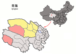
Golmud is part of Haixi Prefecture in western Qinghai Province. Despite being nominally a "city",the built-up urban area of Golmud comprises only 72 km2 (28 sq mi) of the county's 124,500 square kilometres (48,100 sq mi). Most of the county lies in the southern Qaidam Basin and in the foothills of the Kunlun Mountains. A large southern exclave is administered as the "town" of Tanggula,separated from the rest of the county by the western panhandle of the Yushu Tibetan Autonomous Prefecture. The northern part borders Xinjiang to its northwest;the southern exclave borders the Tibetan Autonomous Region to its southwest.
Golmud proper is at an elevation of 2,809 m (9,216 ft). It grew up alongside the Golmud River,which gave it its name.
North of Golmud is the Qarhan Playa,a 5,856 km2 (2,261 sq mi) salt flat with about ten perennial salt lakes. The largest is Dabusun Lake,which receives the waters of the Golmud. The more important smaller lakes are Suli,South Suli,Dabiele,Xiaobiele,Tuanjie,Xiezuo,Dongling,and North and South Hulsan,which receive the waters of smaller inflowing streams. Qarhan is part of the larger Sanhu Depression,which includes East and West Taijinar Lakes. Other major lakes in the southern exclave of Golmud include Ulan Ul Lake (Chinese :乌兰乌拉湖; pinyin :Wūlán WūlāHú) [12] and Migriggyangzham Co (Chinese :赤布张错; pinyin :Chìbùzhāng Cuò,Standard Tibetan :མི་རིག་རྒྱང་གྲམ་མཚོ). [13]
Golmud has a cold arid climate (Köppen BWk ),with long,cold winters,and warm summers. The monthly 24-hour average temperature drops to −8.4 °C (16.9 °F) in January and rises to 18.5 °C (65 °F) in July,while the annual mean is 5.76 °C (42.4 °F). Precipitation is very low,totaling only 45 millimetres (1.77 in) per annum,falling on 28 days,most of which are during the summer. Relative humidity averages only 32%,with all months below 40%,some of the lowest levels nationally. With monthly percent possible sunshine ranging from 62% in July to 81% in November,the city receives 3,096 hours of bright sunshine annually.
Climate data for Golmud,elevation 2,808 m (9,213 ft),(1991–2020 normals,extremes 1951–2020) | |||||||||||||
---|---|---|---|---|---|---|---|---|---|---|---|---|---|
Month | Jan | Feb | Mar | Apr | May | Jun | Jul | Aug | Sep | Oct | Nov | Dec | Year |
Record high °C (°F) | 13.9 (57.0) | 18.0 (64.4) | 24.7 (76.5) | 31.3 (88.3) | 31.0 (87.8) | 32.7 (90.9) | 34.0 (93.2) | 35.5 (95.9) | 31.0 (87.8) | 26.4 (79.5) | 20.6 (69.1) | 10.0 (50.0) | 35.5 (95.9) |
Mean daily maximum °C (°F) | −0.5 (31.1) | 4.4 (39.9) | 9.7 (49.5) | 15.6 (60.1) | 19.7 (67.5) | 23.2 (73.8) | 25.7 (78.3) | 25.0 (77.0) | 20.4 (68.7) | 13.7 (56.7) | 6.4 (43.5) | 0.4 (32.7) | 13.6 (56.6) |
Daily mean °C (°F) | −7.9 (17.8) | −3.5 (25.7) | 1.9 (35.4) | 8.0 (46.4) | 12.6 (54.7) | 16.6 (61.9) | 18.8 (65.8) | 18.0 (64.4) | 13.2 (55.8) | 5.8 (42.4) | −1.5 (29.3) | −7.1 (19.2) | 6.2 (43.2) |
Mean daily minimum °C (°F) | −13.6 (7.5) | −9.8 (14.4) | −4.5 (23.9) | 1.3 (34.3) | 5.9 (42.6) | 10.5 (50.9) | 12.6 (54.7) | 12.1 (53.8) | 7.5 (45.5) | −0.1 (31.8) | −7.3 (18.9) | −12.6 (9.3) | 0.2 (32.3) |
Record low °C (°F) | −33.6 (−28.5) | −26.6 (−15.9) | −26.1 (−15.0) | −13.4 (7.9) | −7.8 (18.0) | −5.2 (22.6) | 1.9 (35.4) | −1.4 (29.5) | −8.2 (17.2) | −20.2 (−4.4) | −25.4 (−13.7) | −28.5 (−19.3) | −33.6 (−28.5) |
Average precipitation mm (inches) | 1.0 (0.04) | 0.6 (0.02) | 0.9 (0.04) | 1.6 (0.06) | 5.0 (0.20) | 9.3 (0.37) | 13.4 (0.53) | 7.8 (0.31) | 4.9 (0.19) | 0.7 (0.03) | 0.8 (0.03) | 0.7 (0.03) | 46.7 (1.85) |
Average precipitation days (≥0.1 mm) | 1.9 | 1.0 | 1.4 | 1.3 | 3.1 | 4.8 | 6.4 | 4.1 | 3.2 | 0.8 | 1.0 | 1.2 | 30.2 |
Average snowy days | 3.2 | 2.5 | 2.6 | 2.0 | 0.8 | 0 | 0 | 0 | 0.1 | 1.1 | 1.5 | 2.0 | 15.8 |
Average relative humidity (%) | 38 | 29 | 25 | 23 | 27 | 34 | 37 | 35 | 34 | 31 | 32 | 38 | 32 |
Mean monthly sunshine hours | 211.4 | 207.6 | 258.2 | 275.4 | 289.6 | 260.2 | 270.3 | 269.8 | 249.5 | 269.5 | 234.4 | 217.6 | 3,013.5 |
Percent possible sunshine | 68 | 67 | 69 | 69 | 66 | 60 | 61 | 65 | 68 | 79 | 77 | 73 | 69 |
Source:China Meteorological Administration [14] [15] [16] NOAA [17] |
Climate data for Xiaozaohuo,Golmud,elevation 2,767 m (9,078 ft),(1991–2020 normals) | |||||||||||||
---|---|---|---|---|---|---|---|---|---|---|---|---|---|
Month | Jan | Feb | Mar | Apr | May | Jun | Jul | Aug | Sep | Oct | Nov | Dec | Year |
Mean daily maximum °C (°F) | −0.8 (30.6) | 4.1 (39.4) | 9.6 (49.3) | 15.6 (60.1) | 20.0 (68.0) | 23.8 (74.8) | 26.3 (79.3) | 25.4 (77.7) | 20.7 (69.3) | 13.6 (56.5) | 6.2 (43.2) | 0.1 (32.2) | 13.7 (56.7) |
Daily mean °C (°F) | −10.3 (13.5) | −5.6 (21.9) | 0.5 (32.9) | 6.8 (44.2) | 11.9 (53.4) | 16.1 (61.0) | 18.2 (64.8) | 17.2 (63.0) | 12.2 (54.0) | 4.0 (39.2) | −3.7 (25.3) | −9.7 (14.5) | 4.8 (40.6) |
Mean daily minimum °C (°F) | −18.4 (−1.1) | −14.1 (6.6) | −7.8 (18.0) | −1.5 (29.3) | 3.9 (39.0) | 8.5 (47.3) | 10.6 (51.1) | 9.7 (49.5) | 4.8 (40.6) | −3.8 (25.2) | −11.5 (11.3) | −17.4 (0.7) | −3.1 (26.5) |
Average precipitation mm (inches) | 0.5 (0.02) | 0.2 (0.01) | 0.5 (0.02) | 0.7 (0.03) | 3.6 (0.14) | 7.1 (0.28) | 7.9 (0.31) | 5.4 (0.21) | 3.6 (0.14) | 0.6 (0.02) | 0.4 (0.02) | 0.3 (0.01) | 30.8 (1.21) |
Average precipitation days (≥0.1 mm) | 1.1 | 0.6 | 0.8 | 0.7 | 2.7 | 4.0 | 5.6 | 3.5 | 2.4 | 0.5 | 0.7 | 0.7 | 23.3 |
Average snowy days | 2.2 | 1.3 | 2.0 | 1.4 | 0.8 | 0 | 0 | 0 | 0 | 0.9 | 1.2 | 1.3 | 11.1 |
Average relative humidity (%) | 38 | 29 | 27 | 27 | 28 | 33 | 38 | 36 | 35 | 33 | 36 | 39 | 33 |
Mean monthly sunshine hours | 227.6 | 216.6 | 262.8 | 276.4 | 291.0 | 264.2 | 271.7 | 272.6 | 256.2 | 276.7 | 243.8 | 231.3 | 3,090.9 |
Percent possible sunshine | 73 | 70 | 70 | 70 | 66 | 60 | 61 | 66 | 70 | 81 | 81 | 78 | 71 |
Source:China Meteorological Administration [18] [19] |
The Qarhan Playa has China's largest reserves of salt,potassium,and magnesium, [20] as well as other valuable minerals. Taken together,the mineral resources in the playa were estimated to be worth over 15 trillion renminbi (RMB) as of 2002. [20] The area's salt has also trapped valuable hydrocarbons. The Sebei-1 and Sebei-2 fields near Suli Lake are also China's 4th-largest onshore reserves of natural gas [7] and the entire area may have reserves as high as 1 trillion m³(35 trillion cu. ft.). [20] The larger Sanhu Depression includes East and West Taijinar,which hold China's largest reserves of lithium.
The surrounding countryside also produces gold,copper,jade,lead,and zinc. [20]
A pipeline delivers crude oil from Huatugou Oilfield to a refinery at Golmud. [7] The refinery has a capacity of 1 million metric tons a year;is able to produce 100,000 metric tons a year of methanol and 20,000 MT/yr of polypropylene;and has a 100,000 MT/yr gas fractionator. [7]
According to the National Ethnic Affairs Commission,the per capita disposable income in Golmud was 6,852 yuan in the first quarter of 2017,a 9.3% increase from the one year prior. [11] Golmud has been one of the areas included in China's Targeted Poverty Alleviation program,which the Commission states has entailed the reconstruction of houses in the city with subpar living conditions,and subsidizing low-income students in the city. [11] The commission also states that the government has been developing the production of traditional woodworking,embroidery,and other local crafts through designated "demonstration areas" (Chinese :示范区; pinyin :shìfàn qū). [11]
Statistics for 2001 show that the city's nominal GDP totaled 2.213 billion RMB,a rise of 31.9% from the previous year [20] [ why? ] and the highest growth rate since 1990. [21]
Golmud lies along the Qinghai–Tibet railway,a 1,956 km (1,215 mi) railway that starts from Xining and ends at Lhasa in the Tibet Autonomous Region. The Golmud-Lhasa section,with a length of 1,142 km (710 mi),was the last and most challenging part of the railway to be completed. After five years of construction,the first train for Lhasa left Golmud on 1 July 2006.
In October 2012 construction started on the Golmud–Dunhuang Railway. It will actually branch off the Qinghai–Tibet Railway at the Yinmaxia station north of Golmud,and will cross the Qaidam Basin and the Altyn-Tagh/Qilian system on the way to Dunhuang in the neighboring Gansu province. [22]
The Golmud-Korla Railway running north west from Golmud into Korla,Xinjiang began construction in November 2014 and was completed in 2020. [23] [24]
![]() | This section needs expansion. You can help by adding to it. (February 2013) |
Golmud is twinned with:
The Golmud Railway is featured as an online multiplayer map in the video game Battlefield 4 .
Zhongxiang is a county-level city of Jingmen,central Hubei province,People's Republic of China. The name Zhongxiang means "Blessed with propitious omen",and was given to the city by the Jiajing Emperor in the Ming dynasty.
Dangyang is a city in western Hubei province,People's Republic of China,lying 70 kilometres (43 mi) east of the Gezhouba Dam on the Yangtze River. During the Western Han dynasty. Emperor Jing of Han established an administration in Dangyang on an area of 2,000 square kilometres (770 sq mi). In 1988 the State Council of the People's Republic of China elevated this from a county to a county-level city,and is currently under the administration of the prefecture-level city of Yichang.
Artush is a county-level city and the capital of Kizilsu Kyrgyz Autonomous Prefecture in Xinjiang,China. The government seat is in Guangming Road Subdistrict. As of 2018,it has a population of 285,507 people,81.4 per cent of whom are Uyghurs.
Seni District is a district within the Nagqu of the Tibet Autonomous Region,China.
Jiangxia District is one of 13 urban districts of the prefecture-level city of Wuhan,the capital of Hubei province,China,situated on the eastern (right) bank of the Yangtze River. Jiangxia district has an area of 2,009 square kilometres (776 sq mi) and a population of 1,308,469 in 2020. It is the southernmost and most sparsely populated of Wuhan's districts. It borders the districts of Caidian and Hannan across the Yangtze and Hongshan to the north,as well as the prefecture-level cities of Ezhou to the east,Huangshi to the southeast,and Xianning to the south.
Anlu is a county-level city in east-central Hubei province,China. It is under the administration of the prefecture-level city of Xiaogan. The siege of De'an took place here during the Song-Jin Wars.
Ruoqiang County as the official romanized name,also transliterated from Uyghur as Qakilik County,is a county in the Xinjiang Uyghur Autonomous Region,China under the administration of the Bayingolin Mongol Autonomous Prefecture. It covers an area of 198,318 square kilometres (76,571 sq mi),making it the largest county-level division in the country.
Yutian County,also transliterated from Uyghur as Keriya County,is a county in Hotan Prefecture,Xinjiang Uyghur Autonomous Region,China. It is based at the Keriya Town,and is separate from Hotan County,which is another county in the same prefecture. The Yutian County has an area of 39,023 km2 (15,067 sq mi). According to the 2002 census,it has a population of 220,000. The county is bounded on the north by Aksu Prefecture,on the east by Minfeng/Niya County,on the west by Qira County and on the south by the Rutog and Gertse counties of the Tibet Autonomous Region.
Pishan County as the official romanized name,also transliterated from Uyghur as Guma County,is a county within the Xinjiang Uyghur Autonomous Region and is under the administration of the Hotan Prefecture. It contains an area of 39,412 km2 (15,217 sq mi). According to the 2002 census,it has a population of 220,000. The county borders Maralbexi County and Makit County to the north,Karakax County,Hotan County and Kunyu to the east and Kargilik County to the west. The county includes lands near the Karakoram Pass which are part of the Aksai Chin area that is disputed between China and India.
Laohekou is a county-level city in the northwest of Hubei province,People's Republic of China. It is located on the Han River (Hanshui),near the Henan border.
Guangshui is a city located in northeastern Hubei province,People's Republic of China,near the border with Henan province. Administratively,it is a county-level city of Suizhou City. Guangshui was known as Yingshan County before December 1988.
Lichuan is a county-level city of the Enshi Tujia and Miao Autonomous Prefecture,in southwestern Hubei province,People's Republic of China,located 52 kilometres (32 mi) west of Enshi City,the prefecture seat. It borders Chongqing Municipality to the southwest,west,and north. It has 750,670 inhabitants.
Hejian is a county-level city under the administration of the prefecture-level city of Cangzhou,in the east-central part of Hebei province,China. As of 2020,the population was ca. 795,198 inhabitants and the city territory was 1,333 km2 (515 sq mi). Hejian is situated along China National Highway 106.
Huangpi District is one of 13 urban districts of the prefecture-level city of Wuhan,the capital of Hubei Province,China,situated on the northern (left) bank of the Yangtze River. The Sheshui enters the Yangtze at Huangpi. The district is primarily rural,but also includes important infrastructure facilities,such as Wuhan Tianhe International Airport and Wuhan North Railway Station,which is one of the main freight stations and classification yards on the Beijing–Guangzhou Railway. It is the northernmost of Wuhan's districts as well as the most spacious. On the left bank of the Yangtze,it borders the districts of Xinzhou to the east,and Jiang'an to the south,and Dongxihu to the southwest;on the opposite bank,it borders Hongshan. It also borders the prefecture-level cities of Huanggang to the northeast and Xiaogan to the northwest. The Sheshui enters the Yangtze River at Shekou in Huangpi.
Hanchuan is a county-level city in east-central Hubei province,People's Republic of China. It is under the administration of Xiaogan prefecture-level city. The city's urban area is located on the left bank of the Han River a few tens of kilometres upstream from Wuhan. However,the county-level city as an administrative unit also includes some land on the right bank of the river as well. The city has been served by the Hanchuan railway station on the Wuhan–Yichang railway. Hanchuan is a sister city of Martinez,California,United States.
Tanggulashan,or Dangla Town,is a town in the southwest of Qinghai province,China. It forms the southern exclave of the county-level city of Golmud,in Haixi Mongol and Tibetan Autonomous Prefecture,partially administrated by Amdo County,Tibet Autonomous Region since 1963 and still officially a territory of Yushu Prefecture,Qinghai under trust administration of Golmud,Haixi Prefecture,Qinghai. Before the local administrative reform of 2005,it was known as Tanggula Township (唐古拉乡). It is the only place in China simultaneously under jurisdiction of three prefectures.
Golmud South railway station is a freight-handling station in Golmud,Haixi Mongol and Tibetan Autonomous Prefecture,Qinghai,China. It is under the jurisdiction of China Railway Qingzang Group.
2000年第五次人口普查,格尔木市总人口135897人,其中:昆仑路街道38214人,金峰路街道26567人,河西街道27417人,郭勒木德乡15771人,大格勒乡2106人,乌图美仁乡1808人,唐古拉山乡1880人,格尔木铁路12249人,格尔木农场9883人。{...}2005年,格尔木市调整乡镇行政区划:撤销郭勒木德乡,设立郭勒木德镇,镇政府驻地和镇区行政区划范围不变,实行镇管村体制。2、撤销唐古拉山乡,设立唐古拉山镇,镇政府驻地和镇区行政区划范围不变,实行镇管村体制。
昆仑经济开发区 东城区工行委 西城区工行委 察尔汗工行委 乌图美仁乡 大格勒乡 郭勒木德镇 唐古拉山镇 昆仑路街道办事处 黄河路街道办事处 河西办事处 金锋路办事处 西藏路办事处
{{citation}}
: CS1 maint: location missing publisher (link).