Searles Lake is an endorheic dry lake in the Searles Valley of the Mojave Desert, in northwestern San Bernardino County, California. The lake in the past was also called Slate Range Lake and Borax Lake.

Golmud, also known by various other romanizations, is a county-level city in the Haixi Mongol and Tibetan Autonomous Prefecture of Qinghai Province, China. It is now the second-largest city in Qinghai and the third largest in the Tibetan Plateau. The population in 2020 is 221,863.

Carnallite (also carnalite) is an evaporite mineral, a hydrated potassium magnesium chloride with formula KCl.MgCl2·6(H2O). It is variably colored yellow to white, reddish, and sometimes colorless or blue. It is usually massive to fibrous with rare pseudohexagonal orthorhombic crystals. The mineral is deliquescent (absorbs moisture from the surrounding air) and specimens must be stored in an airtight container.

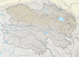
The Qaidam, Tsaidam, or Chaidamu Basin is a hyperarid basin that occupies a large part of Haixi Prefecture in Qinghai Province, China. The basin covers an area of approximately 120,000 km2 (46,000 sq mi), one-fourth of which is covered by saline lakes and playas. Around one third of the basin, about 35,000 km2 (14,000 sq mi), is desert.
Bristol Lake is a dry lake in the Mojave Desert of San Bernardino County, California, 42 km (26 mi) northeast of Twentynine Palms.

Da Qaidam is a county-level administrative zone in Haixi Prefecture in northwestern Qinghai province, China. It borders Gansu province to the north.

The Qarhan or Cha'erhan railway station is a station on the Qingzang Railway at Qarhan in Golmud County, Haixi Prefecture, Qinghai Province, China.
Bromine production in the United States of 225,000 tonnes in 2013 made that country the second-largest producer of bromine, after Israel. The US supplied 29 percent of world production. Since 2007, all US bromine has been produced by two companies in southern Arkansas, which extract bromine from brine pumped from the Smackover Formation. At an advertised price of US$3.50 to US$3.90 per kg, the US 2013 US production would have a value of roughly US$800 million.

Dabusun or Dabuxun Lake, alternately known as Dabasun Nor, is a lake beside the town Qarhan, just north of Golmud in the Haixi Prefecture of Qinghai Province in northwestern China. Fed by the main course of the Golmud River, it is the largest present-day lake in the Qarhan Playa. Like the other lakes of the surrounding Qaidam Basin, it is extremely saline, with 307–338 grams of salt per liter of water (2.5 lb/gallon).
West Dabusun or Dabuxun Lake is an ephemeral lake northwest of Golmud in the Haixi Prefecture of Qinghai Province in northwestern China. Comprising a basin in the Qarhan Playa, it fills when meltwater floods the Golmud River, causing it to spill into subsidiary channels west of the main course to Dabusun Lake. Like the other lakes of the surrounding Qaidam Basin, it is extremely saline.

North or Bei Hulsan Lake, also known by other names, is a lake northeast of Golmud in Dulan County, Haixi Prefecture, Qinghai Province, China. A part of the Qarhan Playa, it is filled from the east by the Qaidam River. Like the other lakes of the surrounding Qaidam Basin, it is extremely saline.

South or Nan Hulsan Lake, also known by other names, is a lake northeast of Golmud in Dulan County, Haixi Prefecture, Qinghai Province, China. A part of the Qarhan Playa, it lies east of Tuanjie Lake and south of North Hulsan Lake. Like the other lakes of the surrounding Qaidam Basin, it is extremely saline.

Tuanjie Lake is a lake in the southeastern Qarhan Playa north of Golmud in the Haixi Prefecture of Qinghai Province in northwestern China. It is fed from the south by the Shougong River. Like the other lakes of the surrounding Qaidam Basin, it is extremely saline.
Xiezuo Lake is a lake in the northeastern Qarhan Playa north of Golmud in Dulan County, Haixi Prefecture, Qinghai Province, China. Like the other lakes of the surrounding Qaidam Basin, it is extremely saline.

Dabiele Lake, also known by other names, is an ephemeral lake in the southwestern Qarhan Playa north of Golmud in the Haixi Prefecture of Qinghai Province in northwestern China. It is fed by the Tuolahai and Qingshui Rivers from the Kunlun Mountains to the south. Like the other lakes of the surrounding Qaidam Basin, it is extremely saline; like the other lakes in the Bieletan subbasin, it is rich in lithium.
Xiaobiele Lake or Xiaobieletan is an ephemeral lake in the southwestern Qarhan Playa north of Golmud in the Haixi Prefecture of Qinghai Province in northwestern China. Like the other lakes of the surrounding Qaidam Basin, it is extremely saline; like the other lakes of the surrounding Bieletan subbasin, it is rich in lithium.
Suli or Senie Lake is a lake in the western Qarhan Playa north of Golmud in the Haixi Prefecture of Qinghai Province in northwestern China. It is fed from the west by the Urt Moron River. Like the other lakes of the surrounding Qaidam Basin, it is extremely saline; like the other lakes of the surrounding Bieletan subbasin, it is rich in lithium. Its underlying salt has also trapped one of China's largest onshore natural gas fields.

Dongling Lake is a lake in the Qarhan Playa north of Golmud in the Haixi Prefecture of Qinghai Province in northwestern China. Like the other lakes of the surrounding Qaidam Basin, it is extremely saline.
South, Little, or New Suli or Senie Lake is a small ephemeral lake in Golmud County, Haixi Prefecture, Qinghai Province, China. It lies in the southwest corner of the Qarhan Playa in the southeast Qaidam Basin. It is part of Qarhan's Bieletan subbasin, located south of Suli Lake and west of Dabiele Lake. It is principally fed from the southwest by the Zaohuo or Little Zaohuo River (小灶火河,Xiǎozàohuǒ Hé) and consists of a 1.5 km2 (0.58 sq mi) basin which gradually evaporates into three smaller ponds. As part of the Bieletan subbasin, it is rich in lithium chloride.
The Golmud or Ge'ermu River is a river in Golmud County, Haixi Prefecture, Qinghai Province, China. It flows north from the Kunlun Mountains to Dabusun and (occasionally) West Dabusun Lakes in the central Qarhan Playa in the southeastern Qaidam Basin. The county seat Golmud lies along it.