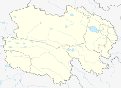
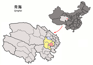
Golmud,also known by various other romanizations,is a county-level city in the Haixi Mongol and Tibetan Autonomous Prefecture of Qinghai Province,China. It is now the second-largest city in Qinghai and the third largest in the Tibetan Plateau. The population in 2020 is 221,863.

Yushu Tibetan Autonomous Prefecture,also transliterated as Yüxü or Yulshul,is an autonomous prefecture of Southwestern Qinghai Province,China. Largely inhabited by Tibetans,the prefecture has an area of 188,794 square kilometres (72,894 sq mi) and its seat is located in the town of Gyêgu in Yushu County,which is the place of the old Tibetan trade mart of Jyekundo. The official source of the Yellow River lies within the prefecture. Historically,the area belongs to the cultural realm of Kham in Eastern Tibet.

Henan Mongol Autonomous County is an autonomous county in the south of Huangnan Tibetan Autonomous Prefecture in the province of Qinghai,China,bordering Gansu Province to the south and east. Its administrative seat ("capital") is the town of Yêgainnyin (Youganning). Henan has an area of 6,250 km2 (2,410 sq mi) and approximately 30,000 inhabitants (2004). The Mongols or Upper Mongols,the overwhelming majority of the inhabitants of the county,do not speak Mongolian and speak primarily Standard Chinese and Tibetan.

Bairi Tibetan Autonomous County,also known as Tianzhu from its Chinese name,is in the prefecture-level city of Wuwei in the central part of Gansu province,China,bordering Qinghai province to the south and west. It has an area of 7,147 km2 (2,759 sq mi) and approximately 230,000 inhabitants (2003). Its administrative seat is Rabgyai Town (Huazangsi).

Jainca County,Chentsa County or Jainzha County is a county in Huangnan Tibetan Autonomous Prefecture in Qinghai Province,China,to Tibetans in the area known as Malho Prefecture,part of Amdo. There are six townships,three towns and a total of 79 administrative villages in Chentsa county. The county has an area of 1714 square kilometres and a population of ~50,000 (2001),67% Tibetan. The county seat is the town of Markhu Thang.

Delingha,or Delhi,is the seat of the Haixi Mongol and Tibetan Autonomous Prefecture in northern Qinghai province,China. It is located approximately 200 km (120 mi) southeast of the Da Qaidam Administrative Region. It is a mainly industrial county-level city. The Bayin River divides the city into two parts:Hedong and Hexi. Because the prefecture seat is located in Hedong,it is slightly more flourishing than Hexi,which is chiefly agricultural.

Ngawa County,or Aba or Ngaba,is a county in the northwest of Sichuan Province,China. It is under the administration of the Ngawa Tibetan and Qiang Autonomous Prefecture. It is located in the remote northwestern part of the prefecture,on the border with Qinghai and Gansu. The county seat is Ngawa Town.

Datong Hui and Tu Autonomous County,Datong County,or Serkhog County is an autonomous county of Hui and Tu peoples in Qinghai Province,China. It is under the administration of the prefecture-level city of Xining,the capital of Qinghai.

Huangyuan County is a county of Qinghai Province,China,it is under the administration of the prefecture-level city of Xining,the capital of Qinghai. It is under the administration of Xining city. The county seat is Chengguan Town,known in Mongolian as Dan Gar and in Tibetan as Tongkor.
Menyuan Hui Autonomous County is a county in the northeast of Qinghai Province,China,bordering Gansu Province to the north. It is under the administration of Haibei Tibetan Autonomous Prefecture. Menyuan is situated on the Datong River between the Qilian Mountains and Daban Mountains. Gangshiqia Peak rises dramatically in the north of the county. It used to be called Menyuan (亹源) in Chinese,with a different first character from the current name.
Guinan County is a county in the east of Qinghai Province,China. It is under the administration of Hainan Tibetan Autonomous Prefecture. The seat of Guinan County is in the Town of Mangqu.

Jigzhi County or Chik Dril is a county of Qinghai Province,China,bordering Sichuan to the southeast and Gansu to the northeast. It is under the administration of Golog Tibetan Autonomous Prefecture. The seat of Jigzhi County is in the Town of Chugqênsumdo.

Zadoi County is a county in the southwest of Qinghai Province,China,bordering the Tibet Autonomous Region to the south. It is under the administration of Yushu Tibetan Autonomous Prefecture. The county seat is in the Town of Qapugtang.

Zhidoi County is a county in the west and southwest of Qinghai Province,China,bordering the autonomous regions of Tibet to the west and Xinjiang to the northwest. It is under the administration of Yushu Tibetan Autonomous Prefecture.

Ulan or Wulan is a county of Qinghai Province,China. It is under the administration of Haixi Mongol and Tibetan Autonomous Prefecture. County seat is Xireg.

Dulan County is a county of east-central Qinghai province,China. It is under the administration of Haixi Mongol and Tibetan Autonomous Prefecture.

Lenghu is a town in Mangnai,Haixi Mongol and Tibetan Autonomous Prefecture. It is located in the northwest of Qinghai province,China,bordering Gansu to the north/northeast and Xinjiang to the northwest.

Da Qaidam is a county-level administrative zone in Haixi Prefecture in northwestern Qinghai province,China. It borders Gansu province to the north.
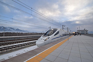
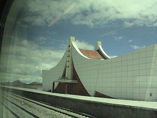
The Togtogquwo railway station or the Tuotuohe railway station is a station on the Chinese Qinghai–Tibet Railway. It is located at 34°13′59.26″N92°26′44.80″E near the railway bridge over the Tuotuo River,which is considered the headwaters of China's great Yangtze River..
Tanggulashan,or Dangla Town,is a town in the southwest of Qinghai province,China. It forms the southern exclave of the county-level city of Golmud,in Haixi Mongol and Tibetan Autonomous Prefecture,partially administrated by Amdo County,Tibet Autonomous Region since 1963 and still officially a territory of Yushu Prefecture,Qinghai under trust administration of Golmud,Haixi Prefecture,Qinghai. Before the local administrative reform of 2005,it was known as Tanggula Township (唐古拉乡). It is the only place in China simultaneously under jurisdiction of three prefectures.