Mangnai 茫崖市 · ᠮᠠᠨᠭᠨᠠᠢ ᠶᠢᠨ ᠬᠣᠲᠠ · མང་ནེ་གྲོང་ཁྱེར། Mang'ai | |
|---|---|
 Entrance of Lenghu Town | |
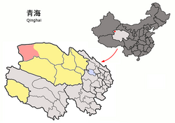 Mangnai (light red) within Haixi Prefecture (yellow) and Qinghai. | |
 Mangnai | |
| Coordinates: 38°15′00″N90°51′25″E / 38.250°N 90.857°E | |
| Country | China |
| Province | Qinghai |
| Autonomous prefecture | Haixi |
| Seat | Huatugou |
| Area | |
• Total | 49,900 km2 (19,300 sq mi) |
| Elevation | 3,000 m (10,000 ft) |
| Population (2020) [1] | |
• Total | 18,856 |
| • Density | 0.38/km2 (0.98/sq mi) |
| Time zone | UTC+8 (China Standard) |
| Website | www |
| Mangnai | |||||||
|---|---|---|---|---|---|---|---|
| Chinese name | |||||||
| Chinese | 茫崖市 | ||||||
| |||||||
| Tibetan name | |||||||
| Tibetan | མང་ནེ་གྲོང་ཁྱེར། | ||||||
| |||||||
| Mongolian name | |||||||
| Mongolian script | ᠮᠠᠨᠭᠨᠠᠢ ᠶᠢᠨᠬᠣᠲᠠ | ||||||
| |||||||
Mangnai,also known as Mang'ai,is a county-level city in the northwest of Qinghai Province,China,bordering Xinjiang to the north and west. It is under the administration of Haixi Mongol and Tibetan Autonomous Prefecture. It is one of the most remote cities in China,the closest other city,Ruoqiang,is located 350 kilometres (220 mi) away. [3] In 2020 it had a population of 18856. [4] The name Mangnai is based on the Mongolian word for 'forehead'. [5]
Contents
It was formed in 2018 when the Mangnai and Lenghu administrative zones merged to establish the county-level city of Mangnai. [5]