This article needs additional citations for verification .(April 2023) |
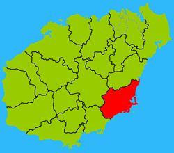
Wanning 万宁市 | |
|---|---|
 Wancheng Town, the seat of Wanning | |
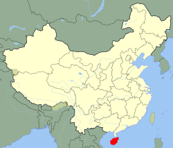
 Map showing entire Qionghai area within Hainan province | |
| Coordinates: 18°47′0″N110°23′0″E / 18.78333°N 110.38333°E | |
| Country | People's Republic of China |
| Province | Hainan |
| Area | |
• Total | 4,443 km2 (1,715 sq mi) |
| • Land | 1,883.5 km2 (727.2 sq mi) |
| • Water | 2,550 km2 (980 sq mi) |
| Population (2010) | |
• Total | 545,597 |
| • Density | 289.67/km2 (750.25/sq mi) |
| Time zone | UTC+8 (China standard time) |
| Wanning | |||||||||||||
|---|---|---|---|---|---|---|---|---|---|---|---|---|---|
| Traditional Chinese | 萬寧 | ||||||||||||
| Simplified Chinese | 万宁 | ||||||||||||
| Postal | Manning | ||||||||||||
| Literal meaning | Uncountably Long Peace | ||||||||||||
| |||||||||||||
Wikivoyage has a travel guide for Wanning .

Wanning, or in local Hainamese dialect as Van Neing or Ban Neing, is a county-level city in the southeast of Hainan Province, China. Although called a "city", Wanning refers to both the county seat and to the entire county as a whole. The county-wide area has an estimated population of 65,871 (2006).