Hebi

Last updated • 2 min readFrom Wikipedia, The Free Encyclopedia
Hebi
鹤壁市
Hopi
Main temple of the City of the Eight Symbols (Ba Gua Cheng ), the holy see of Weixinism (Wei Xin Jiao ) in Hebi (He Bi Shi ), Henan, China.jpg
Cui Bi Cang Yan  - panoramio.jpg
He Bi Bai Huo Da Lou  - panoramio.jpg
View near Hebi East Station 2.jpg
From top, left to right: Temple of the Eight Symbols in Qi County; Pagoda in Xun County; Shancheng District Department Store; View near Hebi East railway station
Hebi
ChinaHenanHebi.png
Location of Hebi in Henan
China Northern Plain relief location map.png
Red pog.svg
Hebi
Location in the North China Plain
China edcp location map.svg
Red pog.svg
Hebi
Hebi (China)
Coordinates(Hebi municipal government): 35°44′53″N114°17′49″E / 35.748°N 114.297°E / 35.748; 114.297
CountryPeople's Republic of China
Province Henan
Municipal seat Qibin District
Area
   Prefecture-level city 2,299 km2 (888 sq mi)
  Urban
 (2018) [1]
543 km2 (210 sq mi)
  Metro
847.3 km2 (327.1 sq mi)
Population
 (2020 census for total, 2018 otherwise) [2]
   Prefecture-level city 1,565,973
  Density680/km2 (1,800/sq mi)
   Urban
 (2018) [1]
667,600
  Urban density1,200/km2 (3,200/sq mi)
   Metro
574,000
  Metro density680/km2 (1,800/sq mi)
GDP [3] [4]
   Prefecture-level city CN¥ 77.2 billion
US$ 11.6 billion
  Per capitaCN¥ 47,940
US$ 7,217
Time zone UTC+8 (China Standard)
Area code 392
ISO 3166 code CN-HA-06
Major Nationalities Han
County-level divisions5
Township-level divisionsunknown
License plate prefixes F
Website hebi.gov.cn

Hebi (simplified Chinese : 鹤壁 ; traditional Chinese : 鶴壁 ; pinyin :Hèbì [xɤ̂.pî] ; postal: Hopi) is a prefecture-level city in northern Henan province, China. Situated in mountainous terrain at the edge of the Shanxi plateau, Hebi is about 25 miles (40 km) south of Anyang, 40 miles (64 km) northeast of Xinxiang and 65 miles (105 km) north of Kaifeng.

Contents

As of the 2020 census, its population was 1,565,973 inhabitants and in the 2018 estimate 574,000 lived in the built-up (or metro) area made of Qibin District and Qi County largely conurbated. One can notice that Shancheng District and Heshan District are for the moment, part of another built-up area of 372,600 inhabitants close to Anyang. [2]

Hebi has several coal mines. The city is also home to Hebi New Area, an economic development zone.

Administration

The prefecture-level city of Hebi administers 3 districts and 2 counties.

Map

Climate

Climate data for Hebi (2010–2020 normals)
MonthJanFebMarAprMayJunJulAugSepOctNovDecYear
Mean daily maximum °C (°F)4.3
(39.7)
8.0
(46.4)
15.2
(59.4)
20.7
(69.3)
27.0
(80.6)
32.7
(90.9)
32.5
(90.5)
30.5
(86.9)
27.0
(80.6)
21.3
(70.3)
13.1
(55.6)
6.7
(44.1)
19.9
(67.9)
Daily mean °C (°F)−1.4
(29.5)
1.8
(35.2)
8.7
(47.7)
14.5
(58.1)
20.9
(69.6)
26.2
(79.2)
27.3
(81.1)
25.6
(78.1)
20.7
(69.3)
15.1
(59.2)
7.5
(45.5)
0.5
(32.9)
13.9
(57.1)
Mean daily minimum °C (°F)−6.0
(21.2)
−3.1
(26.4)
2.7
(36.9)
8.4
(47.1)
14.7
(58.5)
20.1
(68.2)
23.0
(73.4)
21.6
(70.9)
15.8
(60.4)
10.2
(50.4)
2.9
(37.2)
−4.2
(24.4)
8.8
(47.9)
Average precipitation mm (inches)6.1
(0.24)
8.2
(0.32)
5.9
(0.23)
42.3
(1.67)
36.8
(1.45)
65.1
(2.56)
155.1
(6.11)
133.9
(5.27)
64.3
(2.53)
24.2
(0.95)
23.4
(0.92)
3.4
(0.13)
568.7
(22.38)
Average precipitation days (≥ 0.1 mm)2.32.32.75.86.47.010.39.97.65.75.71.467.1
Average relative humidity (%)62605967665976827869706568
Source: China Meteorological Administration [5] [6]

History

The name of "Hebi" first appears in book " History of Jin ". It is believed that during ancient times, cranes would rest on the cliffs of the southern mountains. The southern mountain was then named 鹤山(HeShan), where 鹤 means crane. The village near the southern mountain was then named 鹤壁 (Hebi), which literally translates to "Cranes resting on cliffs").

Relocation of the Urban Area of Hebi

The urban area of Hebi has undergone three relocations. In 1957, the urban area was selected to be in Hebiji. With the construction of the mine #2 and mine #3, the urban area moved south to what is now known as Zhongshan District in December 1957. Later in 1959, the urban area changed from Zhongshan District to another district that is known as Dahu. However, the surrounding areas of the urban area became mostly subsidence areas, restricting further development of the city. Therefore, in 1992, Hebi government established Qibin Economic Development Zone at the junction of Qi County, Junxian County in the southeast. As the scale of the Qibin Economic Development Zone expands, the political center of the city also moved to Qibin District in May 1999. Qibin District is now the new political, economic center of Hebi City.

Related Research Articles

<span class="mw-page-title-main">Yingtan</span> Prefecture-level city in Jiangxi, Peoples Republic of China

Yingtan is a prefecture-level city in the east of Jiangxi province, People's Republic of China, bordering Fujian to the southeast. Its location near the trisection of Jiangxi, Fujian, and Zhejiang has made it a strategically important city for centuries. Today, it continues to be a major rail transport hub. It is best known as the Capital of Copper, and located here is Jiangxi Copper and its smelting factory.

<span class="mw-page-title-main">Anyang</span> Prefecture-level city in Henan, Peoples Republic of China

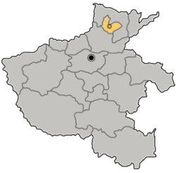
Anyang is a prefecture-level city in Henan, China. The northernmost city in Henan, Anyang borders Puyang to the east, Hebi and Xinxiang to the south, and the provinces of Shanxi and Hebei to its west and north respectively. Anyang had a total population of 5,477,614 as of the 2020 census, 2,675,523 of whom lived in the built-up area made of four urban districts and Anyang and Tangyin counties, now largely agglomerated with the city proper.

<span class="mw-page-title-main">Xinxiang</span> Prefecture-level city in Henan, Peoples Republic of China

Xinxiang is a prefecture-level city in northern Henan province, China.

<span class="mw-page-title-main">Yibin</span> Prefecture-level city in Sichuan, Peoples Republic of China

Yibin is a prefecture-level city in the southeastern part of Sichuan province, China, located at the junction of the Min and Yangtze Rivers. Its population was 4,588,804 inhabitants, according to the 2020 census, of whom 2,158,312 lived in the built-up area comprising three urban districts.

<span class="mw-page-title-main">Xuchang</span> Prefecture-level city in Henan, Peoples Republic of China

Xuchang is a prefecture-level city in central Henan province in Central China. It is bordered by the provincial capital of Zhengzhou to the northwest, Kaifeng to the northeast, Zhoukou to the east, Luohe to the southeast, and Pingdingshan to the southwest.

<span class="mw-page-title-main">Panjin</span> Prefecture-level city in Liaoning, Peoples Republic of China

Panjin is a coastal prefecture-level city in central Liaoning province, People's Republic of China, situated on the northern shore of the Liaodong Bay. It borders Anshan to the east, Yingkou to the southeast, and Jinzhou to the west and north. It is the smallest city in both Liaoning and the entire Northeast China with an administrative area of 3,825 square kilometres (1,477 sq mi), and Liaoning's least populous city with a population of 1,389,691 people as of the 2020 census, all in the built-up area made of the 2 urban districts and Dawa and Panshan counties now largely being conurbated.

<span class="mw-page-title-main">Baishan</span> Prefecture-level city in Jilin, Peoples Republic of China

Baishan, is a prefecture-level city in southeastern Jilin province, in the Dongbei (northeastern) part of China. "白山" literally means "White Mountain", and is named after Changbai Mountain. Baishan borders Yanbian to the east, Tonghua to the southwest, Jilin City to the north, and North Korea to the south.

<span class="mw-page-title-main">Sanmenxia</span> Prefecture-level city in Henan, Peoples Republic of China

Sanmenxia is a prefecture-level city in the west of Henan Province, China. The westernmost prefecture-level city in Henan, Sanmenxia borders Luoyang to the east, Nanyang to the southeast, Shaanxi Province to the west and Shanxi Province to the north. The city lies on the south side of the Yellow River at the point where the river cuts through the Loess Plateau on its way to the North China Plain.

<span class="mw-page-title-main">Qingyuan</span> Prefecture-level city in Guangdong, Peoples Republic of China

Qingyuan, formerly romanized as Tsingyun, is a prefecture-level city in northern Guangdong province, China, on the banks of the Bei or North River. During the 2020 census, its total population was 3,969,473, out of whom 1,738,424 lived in the built-up area made of urbanized Qingcheng and Qingxin districts. The primary spoken language is Cantonese. Covering 19,015 km2 (7,342 sq mi), Qingyuan is Guangdong's largest prefecture-level division by land area, and it borders Guangzhou and Foshan to the south, Shaoguan to the east and northeast, Zhaoqing to the south and southwest, and Hunan province and Guangxi Zhuang Autonomous Region to the north. The urban core is surrounded by mountainous areas but is directly connected with Guangzhou and the Pearl River Delta by Highway 107.

<span class="mw-page-title-main">Puyang</span> Prefecture-level city in Henan, Peoples Republic of China

Puyang is a prefecture-level city in northeastern Henan province, People's Republic of China. Located on the northern shore of the Yellow River, it borders Anyang in the west, Xinxiang in the southwest, and the provinces of Shandong and Hebei in the east and north respectively.

<span class="mw-page-title-main">Xinyang</span> Prefecture-level city in Henan, Peoples Republic of China

Xinyang is a prefecture-level city in southeastern Henan province, People's Republic of China, the southernmost administrative division in the province. Its total population was 6,234,401 according to the 2020 census. As of the 2010 census, 1,230,042 of them lived in the built-up area made of two urban districts, Pingqiao and Shihe.

<span class="mw-page-title-main">Qujing</span> Prefecture-level city in Yunnan, Peoples Republic of China

Qujing is a prefecture-level city in the east of Yunnan province, China, bordering Guizhou province to the east and the Guangxi Zhuang Autonomous Region to the southeast; thus, it was called "Key between Yunnan and Guizhou" (滇黔锁钥) and "Throat of Yunnan" (云南咽喉) in the past. It is part of the Central Yunnan Metropolitan Region plan (滇中城市群规划) in effect for 2016–49. Its administrative population is 6,047,000 according to a 2015 estimate, of whom, 1,408,500 reside in the metro area, which contains Qilin District, Zhanyi District and Malong District. During the 11th National Five-Year Plan period, the government of Qujing planned to develop the city into the "big city at the origin of the Pearl River" (珠江源大城市) in the following decades, including increasing the built-up urban area to past 100 km2 (39 sq mi) and the urban population to surpass 1 million by 2020, the second in Yunnan, after Kunming.

<span class="mw-page-title-main">Dazhou</span> Prefecture-level city in Sichuan, Peoples Republic of China

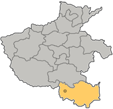
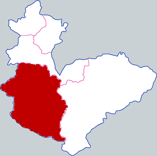
Dazhou is a prefecture-level city in the northeast corner of Sichuan province, China, bordering Shaanxi to the north and Chongqing to the east and south. As of 2020 census, Dazhou was home to 5,385,422 inhabitants whom 1,850,869 lived in the built-up area made of 2 urban districts.

<span class="mw-page-title-main">Liupanshui</span> Prefecture-level city in Guizhou, Peoples Republic of China

Liupanshui is a city in western Guizhou province, People's Republic of China. The name Liupanshui combines the first character from the names of each of the city's three constituent counties: Liuzhi, Panzhou, Shuicheng. As a prefecture-level city with an area of 9,926 square kilometres (3,832 sq mi), Liupanshui had a total population of over 2,830,000 in 2006, making it the second largest in the province, though only 251,900 inhabitants were urban residents. The city is known locally as "The Cool City" or "Cool Capital" due to its low average summer temperature.

<span class="mw-page-title-main">Gushi County</span> County in Henan, Peoples Republic of China

Gushi is a county of 1,023,857 people directly governed by Henan, People's Republic of China. It is administered by the prefecture-level city of Xinyang.

<span class="mw-page-title-main">Urad Rear Banner</span> Banner in Inner Mongolia, China

Urad Rear Banner is a banner of the Inner Mongolia Autonomous Region, China. It is located in the west of the region, 44 kilometres (27 mi) northwest of the city of Bayan Nur, which administers this banner, and borders the Republic of Mongolia's Ömnögovi Province to the north. The banner has a total area of 24,925 km2 (9,624 sq mi) and in 2020 had a population of 53,946. It is located in the prefectural-level municipality of Bayannur city. The capital is moved to the town of Bayan Bulag. This Banner division is also home to the Upper Cretaceous Bayan Mandahu Formation.

Hua County or Huaxian is a county under the administration of Anyang City, in the north of Henan province, China.

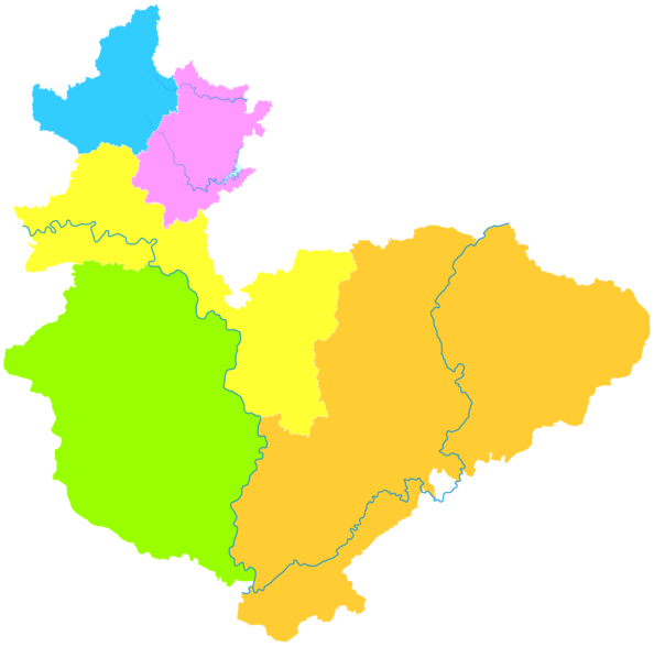
Qibin District is a district of the city of Hebi, Henan province, China.

Heshan District is a district of the city of Hebi, Henan province, China.

<span class="mw-page-title-main">Qi County, Hebi</span> County in Henan, Peoples Republic of China

Qi County or Qixian is a county in the north of Henan province, China. It is under the administration of the Hebi city. Qi County is the location of Zhaoge, the former capital of the Shang dynasty.

References

  1. 1 2 Cox, Wendell (2018). Demographia World Urban Areas. 14th Annual Edition (PDF). St. Louis: Demographia. p. 22.
  2. 1 2 "China: Hénán (Prefectures, Cities, Districts and Counties) - Population Statistics, Charts and Map".
  3. 河南省统计局、国家统计局河南调查总队 (November 2017). 《河南统计年鉴-2017》. 中国统计出版社. ISBN   978-7-5037-8268-8. Archived from the original on 2018-11-15. Retrieved 2018-12-03.
  4. "河南统计年鉴—2017". www.ha.stats.gov.cn. Archived from the original on 2018-11-15. Retrieved 2018-12-03.
  5. 中国气象数据网 – WeatherBk Data (in Simplified Chinese). China Meteorological Administration . Retrieved 7 October 2023.
  6. "Experience Template" 中国气象数据网 (in Simplified Chinese). China Meteorological Administration . Retrieved 7 October 2023.