Baotou[a] is the second-largest city by urban population in Inner Mongolia,China. Governed as a prefecture-level city,its built-up (or metro) area within its five urban districts is home to 2,261,089 people while the total population is 2,709,378 as of the 2020 census.[2]
Baotou's southern border is delineated by the Yellow river. The city's namesake,literally translating to "place with deer",is Mongolian,bringing about the nickname of "Lucheng" (Chinese:鹿城;pinyin:Lùchéng),meaning "City of Deer".[4] Alternatively,Baotou is known as the "City of Steel in the Grasslands" (草原钢城;Cǎoyuán Gāngchéng),since steel was a major industry in the city which is built on the Mongolian grassland and contains a large grassland park. Today,Baotou mines and refines over half of the rare-earth minerals produced in the world. This has led to environmental contamination near the industrial sites.
History
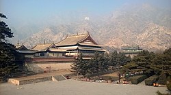
The Deer monument in urban Baotou
Ancient times
The area now known as Baotou was inhabited by nomads,some of whose descendants would later be categorized as Mongols. Near the end of the Han dynasty (206 BC–220 AD),LüBu,a particularly noteworthy warrior,was born in today's Jiuyuan District of Baotou.
Foundation of the town
Compared to the capital of Inner Mongolia,Hohhot,Baotou's construction as a city came relatively late,being incorporated as a town in 1809. The city's site was chosen because it was in an arable region of the Yellow River's Great Bend.
Early 20th century
The Gelaohui secret society and the Hui Muslim General Ma Fuxiang came to an agreement in 1922,in which Ma Fuxiang agreed to allow the Gelaohui to extort protection money from wool merchants in Baotou.[5]
A railway from Beijing was constructed in 1923,and the city began spurring some industrial sites. A German-Chinese joint-venture in 1934 constructed the Baotou Airport and opened a weekly route connecting Baotou with Ningxia and Lanzhou.
When young Owen Lattimore visited Baotou in 1925,it was still "a little husk of a town in a great hollow shell of mud ramparts,where two busy streets made a traders' quarter",but already an important railhead. Qinghai and Gansu wool and hides were brought down the Yellow River by raft and boat from Lanzhou to Baotou,and shipped from Baotou by rail to the east (in particular,to Tianjin for export). The river traffic was one-way only,however,as the fast current made sailing up the Yellow River impractical. To travel from Baotou back to Lanzhou or Yinchuan,one would use a cart and camel road. There were also caravan roads from Baotou to Ordos and the Alxa League.[6]
Second Sino-Japanese War
Baotou was under Japanese control from 1937 until 1945.[citation needed]
Chinese civil war
On September 19,1949,after the September 19 Rebellion,Baotou fell under Communist control.[citation needed] The People's Government was formed in February 1950.[citation needed]
Late 20th century
In the early Communist years,Baotou served as an industrial centre,with a significant portion of its economy coming from its steel production.[citation needed] The Iron and Steel Base in Baotou is one of the "156 projects",which were constructed with the help of the Soviet Union to develop China's national economy in the 1950s and 1960s,and it continues this reputation until this day.[citation needed] Until the middle of the 1960s,the steel complex at Baotou was one of the rare examples of industrialization in the periphery of China.[7]:316
On 3 May 1996, at 03:32AM UTC (11:32AM local time), an earthquake of MS 6.4 occurred. Since the epicenter of the earthquake was located close to the city,[8] Baotou was very damaged by the earthquake: 26 people were killed, 453 injured and 196,633 lost their homes. The electrical infrastructure of the city was also damaged, and soil liquefaction occurred around the swamps of the Yellow River.
The earthquake, which destroyed many old houses, led to the reconstruction of Baotou. In 2002, the Baotou Municipal Government was awarded by UN-HABITAT for the improvements in shelter and the urban environments.[9][10]
21st century
In the early 21st century, Baotou's economy grew rapidly, growing about tenfold from 2000 to 2010.[11] The city's gross domestic product peaked at about 386.763 billion renminbi (RMB) in 2016, and has shrunk significantly since then.[11]
Economy
Baotou is the largest economy of the Inner Mongolia Autonomous Region,[12][needs update] and accounted for approximately 21.3% of Inner Mongolia's total gross domestic product (GDP) as of 2012.[13] As of 2018, the city's GDP is 295.180 billion renminbi (RMB), a 7.22% increase from the previous year, but much lower than the city's peak of 386.763 billion RMB in 2016.[11]
Baotou's secondary sector has proven crucial to the city's economy. As of 2016, it contributed 182.215 RMB to the city's economy, 47.11% of the city's total GDP.[14] However, like the city's total economy, it has shrunk since then.[11][14] As of 2020, the city's secondary sector contributed 115.300 billion RMB to Baotou's economy.[14]
Baotou Xingsheng Economic & Technological Development Zone is an industrial zone in Baotou.[citation needed]
As noted, in the early Communist years, Baotou served as an industrial centre, with a significant portion of its economy coming from its industry around metals, mostly steel. The Iron and Steel Base of Bautou was constructed with the help of the Soviet Union to help China in developing its economy; it was one of the 156 Projects that the Soviets helped build for that purpose in the 1950s and 1960s.[citation needed]
Baotou is a major center for rare-earth metals.[15]Rare-earth minerals from the Bayan Obo Mining District, about 120 kilometres from Baotou, are processed in the city. They are used in many electrical and electronic devices, such as smartphones, TVs, wind turbines, and electric vehicle motors.[16] The toxic byproducts from the refineries are contained by the Baotou Tailings Dam.[16][17]
Demographics
According to the 2020 Chinese Census, Baotou has a permanent population of about 2,709,400 people, up about 59,000 from the 2010 Census.[18] The average household in Baotou comprises 2.27 people, down from 2.65 as of 2010.[18]
Baotou, like many places in China, has an aging population. As per the 2020 Census, 20.19% of Baotou's population is aged 60 and older, 1.49 percentage points above the Chinese national average of 18.70%.[18] 13.70% of Baotou's population is aged 65 and older, 0.20 percentage points above the Chinese national average of 13.50%.[18] The number of people aged 60 and older has grown by 7.42% since 2010, and the number of people aged 65 and older has grown by 4.88% during that same span.[18]
Per the census, 50.7% of the city's population is male, and 49.3% is female.[18]
As of 2020, there are approximately 1,026,400 floating residents of Baotou,[18] that is, residents of the city with a hukou registration elsewhere. This population has increased by 144,100, or 22.37%, since 2010.[18]
Urbanization
As of the 2020 Census, 2,334,400 people, or 86.16% of the city's population, lives in urban areas.[18] The remaining 375,000 people, 13.84% of the city's population, lives in rural areas.[18]
Prominent locations
The 39,000 capacity Baotou Olympic Sports Centre Stadium[19](包头奥林匹克体育中心) is the main sports venue in the city and is used mostly for football matches.[citation needed]
Saihantalah Grasslands Park, central Baotou
Saihantalah Grasslands Park (赛汗塔拉城中草原) or Ecological Reserve is a large urban park in Qingshan district. The 5.5km square park is home to thirty wild animal and bird species and is reputedly one of the largest urban parks in China. It is a popular recreational location and attracts 2 million visitors a year.[citation needed]
The Baotou Tailings Dam or Weikuang Dam is a tailings dam about 20 kilometres outside the main city of Baotou. It is owned by Baotou Steel and contains the toxic waste from rare-earth mineral refineries. Since as early as 2012, there have been reports of serious contamination of the surrounding environment.[21][17][16]
Transportation
Baotou is a terminus for both the Baolan Railway and the Jingbao Railway, heading for Lanzhou in the west and Beijing in the east, respectively. The city is served by two main railway stations, Baotou East Railway Station, and Baotou Railway Station.
Baotou is located in the west of Inner Mongolia, located at the junction of two economic zones: the Bohai Economic Rim and the Upper Yellow River Natural Resources Enrichment Zone (黄河上游资源富集区). Its administrative area borders Mongolia's Dornogovi Province to the north, while the Yellow River, which flows for 214 kilometres (133mi) in the prefecture,[22] is south of the urban area itself. The Tumochuan Plateau (土默川平原), Hetao Plateau, and Yin Mountains cross the urban area and central part of the prefecture. Baotou City ranges in latitude from 41° 20' to 42° 40' N and in longitude from 109° 50' to 111° 25' E.
Climate
Baotou features a cold semi-arid climate (KöppenBSk), marked by long, cold and very dry winters, hot, somewhat humid summers, and strong winds, especially in spring. Temperatures often fall below −15°C (5°F) in winter and rise above 30°C (86°F) in summer. The annual precipitation is approximately 300 millimetres (11.8in), with more than half of it falling in July and August alone. Due to the aridity and elevation, temperature differences between day and night can be large, especially in spring. In 2002, there were 12 instances of dust storms.[22] Temperature extremes recorded since 1951 range from −31.4°C (−25°F) on 27 January 1971 (though an unofficial record low of −32.8°C (−27°F) on 23 December 1935)[23] to 40.4°C (105°F) on 22 June 2005.[24]
Climate data for Baotou, elevation 1,005m (3,297ft), (1991–2020 normals, extremes 1971–2010)
1234中国 国内生产总值:内蒙古:包头[China Gross Domestic Product: Inner Mongolia: Baotou]. ceicdata.com (in Chinese). Archived from the original on 16 October 2021. Retrieved 16 October 2021.
123中国 国内生产总值:第二产业:内蒙古:包头市[China Gross Domestic Product: Secondary Sector: Inner Mongolia: Baotou]. ceicdata.com (in Chinese). Archived from the original on 16 October 2021. Retrieved 16 October 2021.
1234567891011人口状况[Population Status]. baotou.gov.cn (in Chinese). Baotou Municipal People's Government. Archived from the original on 16 October 2021. Retrieved 16 October 2021.
↑Daum 카페. cafe.daum.net. Retrieved 5 October 2017.
↑Yao 姚, Guixuan 桂轩; Di 翟, Wen 文 (1988). 五当召及其在内蒙古历史上的地位[Wudang Temple and its position in Inner Mongolia's history]. Yinshan Academic Journal (in Simplified Chinese) (1).
This page is based on this Wikipedia article Text is available under the CC BY-SA 4.0 license; additional terms may apply. Images, videos and audio are available under their respective licenses.