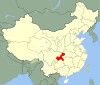
Nanning is the capital and largest city by population of the Guangxi Zhuang Autonomous Region in Southern China. It is known as the "Green City" because of its abundance of lush subtropical foliage. Located in the South of Guangxi, Nanning is surrounded by a hilly basin, with a warm, monsoon-influenced humid subtropical climate.

Baotou is the largest city by urban population in Inner Mongolia, China. Governed as a prefecture-level city, as of the 2020 census, its built-up area made up of its 5 urban districts is home to 2,261,089 people with a total population of 2,709,378 accounting for counties under its jurisdiction. The city's namesake, literally translated to "place with deer", is of Mongolic origin or "Lucheng", meaning "City of Deer". Alternatively Baotou is known as the "City of Steel in Gobi".

China National Highway 110 (G110) runs from Beijing to Qingtongxia, via Hohhot, Baotou in Inner Mongolia, and Yinchuan. It heads northwest from Beijing to Zhangjiakou then heads straight west, and runs to approximately 1,100 kilometers (680 mi).

Jining District is an urban district that serves as the administrative seat of Ulanqab, a region governed as a prefecture-level city in the mid-western part of Inner Mongolia, China. It has an area of approximately 114.2 km2 and is in the southern foothills of the Yinshan mountains.
Huaihua is a prefecture-level city in the southwest of Hunan province, China. It covers 27,564 km2 (10,643 sq mi) and is bordered by Xiangxi to the northwest, Zhangjiajie and Changde to the north, Yiyang, Loudi and Shaoyang to the east, Guilin and Liuzhou of Guangxi to the south, and Qiandongnan and Tongren of Guizhou to the southwest. It has a population of 4,741,948, accounting for 7.22% of the provincial population. According to the 2010 Census, 2,909,574 people, or 61.4% of the population, are Han Chinese. Minorities constitute 38.6% of the population, with 1,832,289 people. The Dong, Miao, Tujia, Yao and Bai are major native minority groups. Huaihua is the central region of the Dong ethnic population, home to nearly 28.35% of the Chinese Dong ethnic group.

Dongsheng District is a District and the seat of Ordos City, Inner Mongolia, People's Republic of China. It has a district population of 574,242. The district is predominantly Han Chinese, but has a significant Mongol minority.

Fu County or Fuxian is a county in the south of Yan'an City, Shaanxi Province, China. The county has an area of 4,179.9 square kilometres (1,613.9 sq mi), and a permanent population of 150,500 as of 2012.

China National Highway 209 (G209) runs from Sonid Left Banner, Inner Mongolia to Beihai, Guangxi province. It is 3,435 kilometres in length and runs south from Huhhot towards Shanxi province, Henan province, Hubei province, Hunan province, and ends in Guangxi province.
Mashan County is a county of Guangxi Zhuang Autonomous Region, China, it is under the administration of the prefecture-level city of Nanning, the capital of Guangxi. The northernmost county-level division of Nanning City, it borders the prefecture-level cities of Hechi to the north and Laibin to the northeast.

China National Highway 207 (G207) runs from Ulanhot, Inner Mongolia to Hai'an, Guangdong. It is 3,738 km (2,323 mi) in length and runs south from Xilinhot through Inner Mongolia, Hebei, Shanxi, Henan, Hubei, Guangxi, and ends in Guangdong.

China National Highway 322 (G322) runs from Hengyang, Hunan to Friendship pass, Guangxi. It is 1039 kilometres in length and runs southwest from Hengyang towards Friendship pass, which is on the China-Vietnam border.

China National Highway 321 (G321) runs northwest from Guangzhou, Guangdong towards Guangxi Province, Guizhou Province, and ends in Chengdu, Sichuan Province. It is 2,220 kilometres in length.

China National Highway 323 (G323) runs southwest from Ruijin, Jiangxi towards Guangdong Province, Guangxi Province, and ends in Lincang, Yunnan, which is on China-Myanmar border. It is 2,915 kilometres in length.

China National Highway 324 (G324) runs west from Fuzhou, Fujian towards Guangdong Province, Guangxi Province, Guizhou Province, and ends in Kunming, Yunnan Province. It is 2,712 kilometres in length.

China National Highway 325 runs west from Guangzhou, Guangdong towards Nanning, Guangxi. It is 868 kilometres in length.

The Beijing–Tongliao or Jingtong railway, also known as the Shahe–Tongliao or Shatong railway, is a railroad in northern China between Beijing, the national capital, and Tongliao in the Inner Mongolia Autonomous Region. The line is 804 km (500 mi) long and runs northwest from Beijing Municipality through Hebei Province to southeastern Inner Mongolia. The line was built between 1972 and 1977, and entered into operations in 1980. Major cities and counties along route include Beijing, Luanping, Longhua, Chifeng and Tongliao.

The Baotou–Maoming Expressway, designated as G65 and commonly referred to as the Baomao Expressway is an expressway that connects the cities of Baotou, Inner Mongolia, China, and Maoming, Guangdong. When fully complete, it will be 3,017 km (1,875 mi) in length.
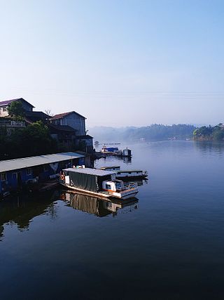
Longsheng is a town in Longsheng Various Nationalities Autonomous County, Guangxi, China. As of 2018 it had a population of 37,000 and an area of 320-square-kilometre (120 sq mi).
Piaoli is a town in Longsheng Various Nationalities Autonomous County, Guangxi, China. As of the 2018 census it had a population of 14,944 and an area of 207.82-square-kilometre (80.24 sq mi).

Longji is a town in Longsheng Various Nationalities Autonomous County, Guangxi, China. As of the 2018 census it had a population of 16,000 and an area of 273.34-square-kilometre (105.54 sq mi). Longji is known worldwide for Longsheng Rice Terraces.