
Amban is a Manchu language term meaning "high official", corresponding to a number of different official titles in the imperial government of Qing China. For instance, members of the Grand Council were called Coohai nashūn-i amban in the Manchu language and Qing governor-generals were called Uheri kadalara amban.

China National Highway 219 is a highway which runs along the entire western and southern border of the People's Republic of China, from Kom-Kanas Mongolian ethnic township in Xinjiang to Dongxing in Guangxi. At over 10,000 kilometres (6,214 mi) long, it is part of the China National Highway Network Planning (2013–2030), and once completed it will be the longest National Highway.

Baicheng County as the official romanized name, also transliterated from Uyghur as Bay County, is a county in Aksu Prefecture of the Xinjiang Uyghur Autonomous Region, People's Republic of China.

Akto County is a county in Kizilsu Kyrgyz Autonomous Prefecture, Xinjiang Uygur Autonomous Region, China. The county borders Tajikistan and Kyrgyzstan and has two towns, 11 townships, four state-owned farms and a plant nursery under its jurisdiction with the county seat being Akto Town. The county contains an area of 24,555 km2 (9,481 sq mi) and has a population of 231,756.
Dzongka or Zongga is a town and the administrative headquarters of Gyirong County in the southwestern Tibet region of China bordering Nepal. Being the administrative headquarters, it is also sometimes referred to as "Gyirong Dzong" or "Gyirong Town", but it is different from the original Kyirong Town in the southern part of the county.

Zhangmu, Dram, or Khasa in Nepali, is a customs town and port of entry located in Nyalam County on the Nepal-China border, just uphill and across the Bhote Koshi River from the Nepalese town of Kodari. At 2,300 metres (7,500 ft) above sea level, Zhangmu has mild and humid subtropical climate, which is a rarity for Tibet.
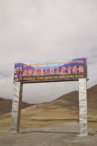
Kyirong County or Gyirong County, called Jilong County by China Chinese: 吉隆县; pinyin: Jílóng Xiàn), is a county of the Shigatse Prefecture, Tibet Autonomous Region. It is famous because of its mild climatically conditions and its abundant vegetation which is unusual for the Tibetan plateau. The capital lies at Zongga. Its name in Tibetan, Dzongka means "mud walls".
Tingri County or Dhringgri County, is a county under the administration of the prefecture-level city of Xigazê in the Tibet Autonomous Region of China.

Drongpa County or Zhongba County (Tibetan: འབྲོང་པ་རྫོང་, Wylie: `brong pa rdzong, THL: drong pa dzong, ZYPY: Zhongba Zong; Chinese: 仲巴县; pinyin: Zhōngbā Xiàn; lit. 'Place of Wild Yaks') is a county of Shigatse Prefecture in China's Tibet Autonomous Region. Located in the western part of Central Tibet, it is the birthplace of the Tsangpo River (Brahmaputra). The county seat is at Labrang, which is also called the Drongpa Town.

Saga County is a county of the prefecture-level city of Xigazê in the Tibet Autonomous Region, bordering Nepal to the west and southwest. Dajia Lake and Jiesa Lake lies in the county.

Kobresia is a genus of plants in the sedge family. They are sometimes called bog sedges. These perennial sedges are quite similar to Carex species in appearance. The genus is widespread across much of Europe, Asia and North America, with many species native to the Himalayas.

China National Highway 310 (G310) runs northwest from Lianyungang, Jiangsu towards Anhui, Henan, Shaanxi provinces, and ends in Tianshui, Gansu. It was originally 1613 kilometres in length, but was later extended westward to Gonghe County in Qinghai.

Kodari is a small village located at the border with Tibet-China. The village is located at the end–point of the Arniko Highway, which connects Kodari with the capital city of Kathmandu. Kathmandu is 144 kilometres (89 mi) away from Kodari. Kodari is a major border crossing from Nepal into the Tibet Autonomous Region.

The Lhasa–Xigazê railway, or La'ri railway, is a high-elevation railway that connects Lhasa to Xigazê, in the Tibet Autonomous Region. The travel time between Lhasa and Xigazê on this line is roughly three hours.
Kyirong or Gyirong , Jilong in Chinese and Kerung in Nepalese, is a town situated in the southern part of Gyirong County in the Tibet Autonomous Region, China. The town is situated on the east bank of Kyirong Tsangpo, a source stream of the Trishuli River, at an elevation of about 2,700 metres (8,900 ft). It has a subtropical mountain monsoon climate, with reasonable precipitation and warm weather, unusual for Tibet.
The China–Nepal Railway is a planned railway between China and Nepal. The railway will link Kathmandu with Shigatse, Tibet, crossing the China–Nepal border at Gyirong–Rasuwa.

Kekeate Pass (Chinese: 柯克阿特达坂; pinyin: Kēkèā'ěrtè Dábǎn), also refer to it as Heiqiazi Pass, Heika Pass or Heiqia Daban(Chinese: 黑卡子达坂; pinyin: Hēiqiǎzi Dábǎn; lit. 'black hairpin pass') is a mountain pass along the China National Highway 219 with numerous hairpin turns. The mountain pass connects the Yarkand River valley to the west with the Karakash River valley to the east. Located at 309 kilometres (192 mi) from the northern terminus of the G219 highway, it is between the village of Mazar in Kargilik County and the town of Xaidulla in Hotan County near the boundary of the two counties. Western sources often known it as as Kirgizjangal Pass,
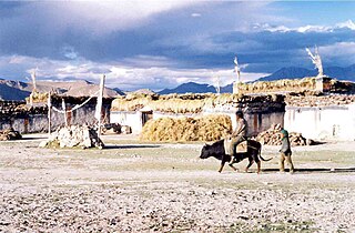
Transport in Tibet has steadily improved with the rapid development of the local economy.

