
Changzhi is a prefecture-level city in the southeast of Shanxi Province, China, bordering the provinces of Hebei and Henan to the northeast and east, respectively. Historically, the city was one of the 36 administrative areas extant under the reign of the first emperor of a unified China.
Liling is a county-level city and the 12th most populous county-level division in Hunan Province, China; it is under the administration of the prefecture-level city of Zhuzhou. Located on the middle eastern margin of the province, the city is bordered to the north by Liuyang City, to the west by Lusong District and Zhuzhou County, to the south by You County, to the east by Xiangdong District of Yichun, Shangli County of Jiangxi. Liling City covers 2,157 km2 (833 sq mi) with registered population of 978,900 and resident population of 1,060,000.

Pu'er is a prefecture-level city in southern Yunnan Province, China. The urban administrative center of Pu'er is Simao District, which is also the former name of the prefecture-level city itself. A major downturn in the price of tea in 2007 caused severe economic distress in the area. The price of Pu'er has since recovered and Pu'er tea, a type of dark tea, still contributes much to the income of the area.

Shangluo is a prefecture-level city in southeastern Shaanxi province, People's Republic of China, bordering Henan to the northeast and Hubei to the southeast. Part of the Shannan region of the province, it is located in the eastern part of the Qin Mountains.

Laiyang city is a county-level city within Yantai bordering Qingdao, located in the middle of the Shandong Peninsula, in Shandong province, China. The majority (70%) of its population are farmers and it is famous for producing the Laiyang pear. As of 2010, it had a population of 923,000.

Diqing Tibetan Autonomous Prefecture is an autonomous prefecture in northwestern Yunnan province, China. Covering an area of 23,870 km2 (9,220 sq mi), it is bordered by the Tibet Autonomous Region to the northwest, Sichuan province to the northeast, and other parts of Yunnan province to the southwest and southeast; Nujiang Lisu Autonomous Prefecture and Lijiang, respectively. Its capital and largest city is Shangri-La.

Baiyin is a prefecture-level city in northeastern Gansu province, People's Republic of China. Established in the 1950s as a base for mining non-ferrous metals, its mines are becoming exhausted in recent decades, requiring the city to reinvent its economy. Located around 60 km (37 mi) from Gansu's capital Lanzhou, it is part of the Lanzhou-Baiyin Economic Belt.

Qingyang is a prefecture-level city in eastern Gansu province, China.

Tongchuan is a prefecture-level city located in central Shaanxi province, People's Republic of China on the southern fringe of the Loess Plateau that defines the northern half of the province (Shanbei) and the northern reaches of the Guanzhong Plain.

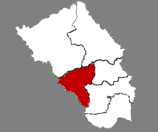
Min County or Minxian is administratively under the control of the prefecture-level city of Dingxi, in the south of Gansu province, China. In ancient times, it was known as Lintao County due to its location along the Tao River. It was founded as Minzhou (岷州) in 544, named after the Min Mountains in the south of the county. The county received its present name in 1913. In 1985 it became subordinate to Dingxi. Min county is well known by Angelica sinensis which is a Chinese traditional medicine.

Wen County or Wenxian is a county under the administration of the prefecture-level city of Longnan, in the southeast of Gansu province, China, bordering Sichuan province to the south and west. It has a land area of 4,994 square kilometers, and a population of 241,000 (2019), notably having the largest population of Baima people.

Jingyuan County is a county in the east of Gansu Province. It is under the administration of Baiyin City, and consists of two separate tracts of territory to the north and south of Pingchuan District. The northern tract borders Ningxia to the north. The southern area consists of an irrigated area around the Yellow River and the northern area is semi-arid highlands.

Wudu District is a district and the political and cultural centre of Longnan, Gansu province, China. It borders the provinces of Shaanxi and Sichuan to the southeast. It has a population of 590,000, of which 110,000 live in the urban area.

China National Highway 207 (G207) runs from Ulanhot, Inner Mongolia to Hai'an, Guangdong. It is 3,738 km (2,323 mi) in length and runs south from Xilinhot through Inner Mongolia, Hebei, Shanxi, Henan, Hubei, Guangxi, and ends in Guangdong.

China National Highway 221 (221国道) runs from Harbin to Tongjiang, in Heilongjiang Province. It is 668 kilometres in length and runs northeast from Harbin towards Tongjiang.

China National Highway 220 runs from Binzhou, Shandong to Zhengzhou, Henan. It is 585 kilometres in length and runs southwest from Binzhou towards Zhengzhou.
Xuecheng is a district and the seat of Zaozhuang, Shandong province, China, ever named by "lin cheng ". It has an area of 506.72 km2 and around 405,285 inhabitants (2003). As of the end of 2022, the resident population of Xuecheng District was 485,637.As of May 2022, Xuecheng District has five streets and four towns under its jurisdiction, with the district government stationed at No. 2 Yongfu Middle Road.Xuecheng is the hometown of national suona, national paper-cutting hometown, national martial arts hometown, national advanced district of mass culture, the birthplace of Shandong Express Scripts, the hometown of Xi Zhong, the originator of car-making, and the hometown of railroad guerrillas.
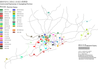
Expressways in Guangdong are a major form of transportation in Guangdong province. The network consists of national expressways assigned by National Trunk Highway System in China and provincial expressways assigned by Guangdong Expressway system. Expressways in Guangdong usually need a fare of 0.45 CNY/km for a private car due to the provincial standard, while more needed for a larger vehicle. Speed limits also vary with the type of vehicles that usually ranged from 60–120 km/h (37–75 mph).
The Jiansanjiang–Heixiazi Island Expressway, commonly referred to as the Jianhei Expressway and designated G1012, is an expressway linking the town of Jiansanjiang with Hexiazi Island, entirely in the prefectural-level city of Jiamusi in the Chinese province of Heilongjiang. It is 217 kilometres (135 mi) in length and opened on 13 August 2017. Prior to the national-level G designation, the highway was designated S14 by the province.

China National Highway 573 runs from Zêkog to Xinghai, both in Qinghai. It is one of the new trunk highways proposed in the China National Highway Network Planning.

