
A highway is any public or private road or other public way on land. It is used for major roads, but also includes other public roads and public tracks. In the United States, it is used as an equivalent term to controlled-access highway, or a translation for Autobahn, autoroute, etc.

The Asian Highway Network (AH), also known as the Great Asian Highway, is a cooperative project among countries in Asia and the United Nations Economic and Social Commission for Asia and the Pacific (ESCAP) to improve their connectivity via highway systems. It is one of the three pillars of the Asian Land Transport Infrastructure Development (ALTID) project, endorsed by the ESCAP commission at its 48th session in 1992, comprising Asian Highway, Trans-Asian Railway (TAR) and facilitation of land transport projects.

China's National Highway 107 runs from Beijing to Hong Kong SAR via Wuhan. It runs to approximately 2,698 km, and, on a map, runs broadly on a straight line from Beijing to Shenzhen. In 2013, under a new 2013-2030 plan by the National Development and Reform Commission and the Ministry of Transport, the G107 has been extended to Hong Kong.
Hà Tĩnh is a northern coastal province in the North Central Coast region, the Central of Vietnam. It borders Nghệ An to the north, Quảng Bình to the south, Bolikhamsai and Khammouane of Laos to the west and the East Sea to the east.

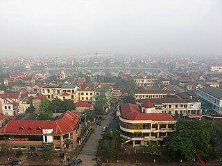
Phú Thọ is a province in northern Vietnam. Its capital is Việt Trì, which is 80 kilometres (50 mi) from Hanoi and 50 kilometres (31 mi) from Nội Bài International Airport. The province covers an area of 3534.56 square kilometres and, as of 2019, it had a population of 1,463,726.

Mondulkiri is a province (khaet) of Cambodia. Bordering the provinces of Kratié to the west, Stung Treng to the northwest, Ratanakiri to the north, and the country of Vietnam to the east and south. It is the most sparsely populated province in the country despite being the largest in land area. The province was established in 1961 from the eastern part of Kratié province. The capital is the town of Senmonorom.

China National Highway 212 (G212) runs from Lanzhou in Gansu to Chongqing. It was originally 1302 kilometres in length. In the 2013 National Highway Network Planning it was extended to Longbang, Guangxi, on the border with Vietnam. After the extension, the length is circa 2,300 km (1,400 mi).

National Route 1, also known as National Route 1A, is the trans-Vietnam highway. The route begins at km 0 at Hữu Nghị Quan Border Gate near the China-Vietnam border, runs the length of the country connecting major cities including Hanoi, Da Nang and Ho Chi Minh City, and ends at km 2301.34 at Năm Căn township in Cà Mau Province.
Ho Chi Minh Road or Ho Chi Minh Highway is a highway in Vietnam. It runs from the north to the south of Vietnam, west of National Route 1. The highway was named after Hồ Chí Minh.
The Hekou Yao Autonomous County is an autonomous county in the southern part of the Yunnan province of China. It is part of the Honghe Hani and Yi Autonomous Prefecture and borders the northern Vietnamese city of Lào Cai. It was apparently known as Zhongcheng during the Tang dynasty.
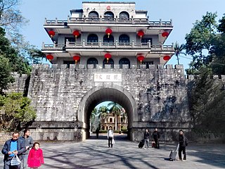
Friendship Pass, also commonly known by its older name Ải Nam Quan, is a pass near the China-Vietnam border, between China's Guangxi and Vietnam's Lạng Sơn Province. The pass itself lies just inside the Chinese side of the border.

China National Highway 210 (G210) runs from Mandula in Baotou, Inner Mongolia to Fangchenggang, Guangxi. It is 3,097 kilometres in length and runs south from Baotou and passes through the province-level divisions of Shaanxi, Sichuan, Chongqing, Guizhou, and ends in Guangxi.

China National Highway 318 (G318) runs from Shanghai to Zhangmu on the China-Nepal border. It is the longest China National Highway at 5,476 kilometres (3,403 mi) in length and runs west from Shanghai towards Zhejiang, Anhui, Hubei, Chongqing, Sichuan, and ends in Tibet Autonomous Region. From Lhasa to Zhangmu it is also called Friendship Highway. From Markam to Zogang it shares the highway with G214. At the Sino-Nepal Friendship Bridge, it connects with the 115 km long Araniko Highway to Kathmandu.

China National Highway 305 (G305) runs northwest from Zhuanghe, Liaoning towards Linxi, Inner Mongolia. It is 815 kilometres in length.

China National Highway 314 (G314) runs southwest from Urumqi, Xinjiang towards the Khunjerab Pass, which is on the northern border of the Gilgit–Baltistan territory in Pakistan-administered Kashmir. The highway is 1,948 kilometres (1,210 mi) in length. It goes southeast from Urumqi and south of Toksun it turns west and follows the north side of the Tarim Basin to Kashgar. From Kashgar, it runs south to Pakistan.

National Route 9 runs across Vietnam roughly in line with the 17th Parallel. The route includes two segments. The segment called National Route 9A begins at Đông Hà and ends at Lao Bảo on the Vietnam-Laos border and is entirely within Quảng Trị Province. The 8 km-long segment called National Route 9B begins at Dong Ha and runs eastward to Cửa Việt Port.

National Route 7, formerly called National Route 7A (QL7A) is a national highway in Vietnam which runs entirely in Nghệ An Province, North Central Vietnam. The 225 kilometer-long route runs from Diễn Châu northwestward across Yên Thành, Đô Lương, Anh Sơn, Con Cuông, Tương Dương, and Kỳ Sơn districts and reach the Laos-Vietnam border at Nậm Cắn. In Nậm Cắn, National Route 7 connects with National Route 7 of Laos.

The G7211 Nanning–Youyiguan Expressway, commonly referred to as the Nanyou Expressway, is a 225.06-kilometre-long expressway (139.85 mi) in the Chinese autonomous region of Guangxi that connects the city of Nanning, the capital of Guangxi, and Friendship Pass, known in Chinese as Youyiguan, a border crossing between China and Vietnam. The Friendship Pass is located in the county-level city of Pingxiang, under the administration of the city of Chongzuo. At the border, the expressway connects with the North–South Expressway East in Vietnam. The expressway is designated G7211, and opened on 28 December 2005.

China National Highway 228 (228国道) is a planned highway of the National Highway System of the People's Republic of China to run from Dandong, Liaoning on the China–North Korea border to Dongxing, Guangxi on the China–Vietnam border.

Asian Highway 17 (AH17) is a road in the Asian Highway Network that runs entirely in Vietnam. The route starts in Da Nang, follows the National Routes 14B, 14, 13, 51 and ends in Vũng Tàu.

