
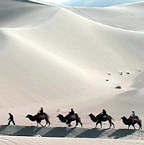
The Taklamakan Desert is a desert in Southwest Xinjiang in Northwest China. It is bounded by the Kunlun Mountains to the south, the Pamir Mountains to the west, the Tian Shan range to the north, and the Gobi Desert to the east.
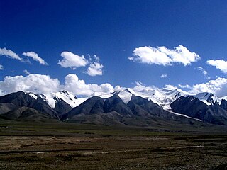
The Kunlun Mountains constitute one of the longest mountain chains in Asia, extending for more than 3,000 kilometres (1,900 mi). In the broadest sense, the chain forms the northern edge of the Tibetan Plateau south of the Tarim Basin. The name originated from the Mongolian word Хөндлөн Khöndlön, meaning "Horizontal", referring to its characteristics.

Lop Nur or Lop Nor is a former salt lake, now largely dried up, located between the Taklamakan and Kumtag deserts in the southeastern portion of the Xinjiang. Administratively, the lake is in Lop Nur town, also known as Luozhong of Ruoqiang County, which in its turn is part of the Bayingolin Mongol Autonomous Prefecture.

The Tarim River, known in Sanskrit as the Śītā, is an endorheic river in Xinjiang, China. It is the principal river of the Tarim Basin, a desert region of Central Asia between the Tian Shan and Kunlun Mountains. The river historically terminated at Lop Nur, but today reaches no further than Taitema Lake before drying out.

Hotan is a major oasis town in southwestern Xinjiang, an autonomous region in Western China. The city proper of Hotan broke off from the larger Hotan County to become an administrative area in its own right in August 1984. It is the seat of Hotan Prefecture.

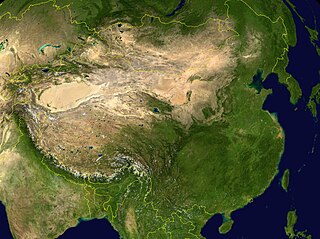
The Tarim Basin is an endorheic basin in Northwest China occupying an area of about 1,020,000 km2 (390,000 sq mi). Located in China's Xinjiang region, it is sometimes used synonymously to refer to the southern half of the province, or Nanjiang, as opposed to the northern half of the province known as Dzungaria or Beijiang. Its northern boundary is the Tian Shan mountain range and its southern boundary is the Kunlun Mountains on the edge of the Tibetan Plateau. The Taklamakan Desert dominates much of the basin. The historical Uyghur name for the Tarim Basin is Altishahr, which means 'six cities' in Uyghur.

The Karakoram Highway is a 1,300 km (810 mi) national highway which extends from Hasan Abdal in the Punjab province of Pakistan to the Khunjerab Pass in Gilgit-Baltistan, where it crosses into China and becomes China National Highway 314. The highway connects the Pakistani provinces of Punjab and Khyber Pakhtunkhwa plus Gilgit-Baltistan with China's Xinjiang Uyghur Autonomous Region. The highway is a popular tourist attraction and is one of the highest paved roads in the world, passing through the Karakoram mountain range, at 36°51′00″N75°25′40″E at maximum elevation of 4,714 m (15,466 ft) near Khunjerab Pass. Due to its high elevation and the difficult conditions in which it was constructed, it is often referred to as the Eighth Wonder of the World. The highway is also a part of the Asian Highway AH4.

Yining, also known as Ghulja or Qulja and formerly Ningyuan (寧遠), is a county-level city in Northwestern Xinjiang, People's Republic of China and the seat of the Ili Kazakh Autonomous Prefecture. Historically, Yining is the successor to the ruined city of Almaliq in neighbouring Huocheng County. Yining is the third largest city in Xinjiang after Ürümqi and Korla.

Altyn-Tagh is a mountain range in Northwestern China that separates the Eastern Tarim Basin from the Tibetan Plateau. The western third is in Xinjiang while the eastern part forms the border between Qinghai to the south and Xinjiang and Gansu to the north.

The Aksu River is a transboundary river in the Xinjiang province in China and Ak-Suu District of Issyk-Kul Province of Kyrgyzstan. In Kyrgyzstan, it is known as the Saryjaz. The total length of the river is 282 kilometres (175 mi), of which 197 kilometres (122 mi) are in Kyrgyzstan. It has a drainage basin of 12,900 square kilometres (5,000 sq mi) in Kyrgyzstan. The Aksu is the only one of the Tarim's source rivers to run throughout the year.
The Kumtag Desert, is an arid landform in Northwestern China, which was proclaimed as a national park in the year 2002.

The Gurbantünggüt Desert occupies a large part of the Dzungarian Basin in Northern Xinjiang, in the northwest of the People's Republic of China. It is also called by some sources as Dzoosotoyn Elisen Desert, presumably from a Mongolian language.

The Sanju, or Sanju-la, with an elevation of 5,364 metres (17,598 ft), is a historical mountain pass in the Kun Lun Mountains in Pishan County, Hotan Prefecture, Xinjiang, China. During ancient times, it was the last on a series of difficult passes on the most common summer caravan route between Ladakh and the Tarim Basin. In recent years, besides being used by the locals, it has also become a trekking route for Chinese trekkers.

China National Highway 314 (G314) runs southwest from Urumqi, Xinjiang towards Khunjerab Pass, which is on the northern border of Pakistan. It is 1,948 kilometres (1,210 mi) in length. It goes southeast from Urumchi and south of Toksun it turns west and follows the north side of the Tarim Basin to Kashgar. From Kashgar it runs south to Pakistan.

Constructed in 1954, the Qinghai-Xinjiang Highway, also known as the China National Highway 315 (G315) runs west from Xining, Qinghai towards Kashgar, Xinjiang. It is 3,063 kilometres (1,903 mi) in length. In 1994 the departments of communication and transportation in Qinghai and Xinjiang began the process of updating the highway. In the west it follows the desert Qaidam Basin south of the traditional Silk Road, crosses the Altyn-Tagh into Xinjiang, and then follows the south side of the Tarim Basin to Kashgar.

Xinjiang, officially Xinjiang Uygur Autonomous Region (XUAR), is an autonomous region of the People's Republic of China (PRC), located in the northwest of the country close to Central Asia. Being the largest province-level division of China and the 8th-largest country subdivision in the world, Xinjiang spans over 1.6 million square kilometres (620,000 sq mi) and has about 25 million inhabitants.
Geku railway is a railway connecting Golmud and Korla, in western China. Construction started in November 2014 and was completed in 2020. The length of the line is 1,214 kilometers, joining Qinghai province and Xinjiang province. The investment is estimated to be CN¥36 billion. The line will connect the existing Qinghai–Tibet railway and the Southern Xinjiang railway. It will be the third railway connecting Xinjiang province with another Chinese province and the third line to Golmud after the Qinghai–Tibet railway and the Golmud–Dunhuang railway which is also under construction.

The Qingshuihe–Yining Expressway, commonly referred to as the Qingyi Expressway, is a 56.36-kilometre-long-Chinese expressway (35.02 mi) in the Ili Kazakh Autonomous Prefecture of Xinjiang, China. It connects the towns of Qingshuihe, in Huocheng County, and Bayandai, in Yining City. It opened on 20 April 2009.

The historical area of what is modern day Xinjiang consisted of the distinct areas of the Tarim Basin and Dzungaria and was populated by Indo-European Tocharians and Saka peoples, who practiced Buddhism. They came under Chinese rule in the Han dynasty as the Protectorate of the Western Regions due to wars between the Han dynasty and the Xiongnu and again in the Tang dynasty as the Protectorate General to Pacify the West due to wars between the Tang dynasty and the First, Western, and Eastern Turkic Khaganates. The Tang dynasty withdrew its control of Xinjiang in the Protectorate General to Pacify the West and the Four Garrisons of Anxi after the An Lushan Rebellion, after which the Turkic peoples living in the area converted to Islam.
This article summarizes the History of the eastern steppe, the eastern third of the Eurasian Steppe, that is, the grasslands of Mongolia and northern China. It is a companion to History of the central steppe and History of the western steppe. Most of its recorded history deals with conflicts between the Chinese and the steppe nomads. Most of the sources are Chinese.

