
Ili Kazakh Autonomous Prefecture is an autonomous prefecture in northern Xinjiang, China. The prefecture seat is Yining, also known by its Uyghur name Ghulja. It borders Mongolia, Russia, and Kazakhstan from the northeast to southwest, with a boundary line of 2,019 kilometers. Including Khorgas, Bakhty and Jeminay, there are 9 ports of entry at the national level. With the unique location advantage, Ili has been an important commercial hub and international channel of opening up to the west.

The Tarim River, known in Sanskrit as the Śītā, is an endorheic river in Xinjiang, China. It is the principal river of the Tarim Basin, a desert region of Central Asia between the Tian Shan and Kunlun Mountains. The river historically terminated at Lop Nur, but today reaches no further than Taitema Lake before drying out.

Hotan or Hetian is a major oasis town in southwestern Xinjiang, an autonomous region in Western China. The city proper of Hotan broke off from the larger Hotan County to become an administrative area in its own right in August 1984. It is the seat of Hotan Prefecture.

The Karakoram Highway is a 1,300 km (810 mi) national highway which extends from Hasan Abdal in the Punjab province of Pakistan to the Khunjerab Pass in Gilgit-Baltistan, where it crosses into China and becomes China National Highway 314. The highway connects the Pakistani provinces of Punjab and Khyber Pakhtunkhwa plus Gilgit-Baltistan with China's Xinjiang Uyghur Autonomous Region. The highway is a popular tourist attraction and is one of the highest paved roads in the world, passing through the Karakoram mountain range, at 36°51′00″N75°25′40″E at maximum elevation of 4,714 m (15,466 ft) near Khunjerab Pass. Due to its high elevation and the difficult conditions under which it was constructed, it is often referred to as the Eighth Wonder of the World. The highway is also a part of the Asian Highway AH4.

Fukang is a county-level city in Xinjiang Uygur Autonomous Region, China. Its area is 11,726 km2 (4,527 sq mi) and its population in 2007 was reported as approximately 1.5 million. Fukang is located in Northern Xinjiang in Changji Hui Autonomous Prefecture, north of Ürümqi.

Highway 1 is the main highway in Israel, connecting Tel Aviv and Jerusalem, and continuing eastwards to the Jordan Valley in the West Bank.

China National Highway 219 is a highway which runs along the entire western and southern border of the People's Republic of China, from Kom-Kanas Mongolian ethnic township in Xinjiang to Dongxing in Guangxi. At over 10,000 kilometres (6,214 mi) long, it is part of the China National Highway Network Planning (2013–2030), and once completed it will be the longest National Highway.

Ulugqat County is a county in Xinjiang Uygur Autonomous Region, China. It is under the administration of the Kyrgyz autonomous prefecture of Kizilsu. The county has two towns, nine townships and one state-owned farm, eight communities and 34 villages under its jurisdiction in 2017, its county seat is Wuqia Town. It contains an area of 19,118.11 km2 (7,381.54 sq mi) and has a population of 56,633 with main ethnic groups of Kyrgyz, Han and Uyghur peoples.

Akto County is a county in Kizilsu Kyrgyz Autonomous Prefecture, Xinjiang Uygur Autonomous Region, China. The county borders Tajikistan and Kyrgyzstan and has two towns, 11 townships, four state-owned farms and a plant nursery under its jurisdiction with the county seat being Akto Town. The county contains an area of 24,555 km2 (9,481 sq mi) and has a population of 231,756.
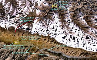
Hindu-tagh Pass, also known as Hindutash, is a historical mountain pass in the western Xinjiang, China. The pass cuts through the Kunlun Mountains connecting the now-deserted town of Kangxiwar in the Karakash River valley to the town of Pusha in the Pusha Jilga valley. It also connects to the road to the city of Hotan.

The Gurbantünggüt Desert occupies a large part of the Dzungarian Basin in Northern Xinjiang, in the northwest of the People's Republic of China. It is also called by some sources Dzoosotoyn Elisen Desert, presumably from a Mongolian language.
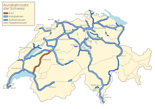
The A12 motorway, an Autobahn in western Switzerland, is a divided highway connecting the A9 to the A1.

Constructed in 1954, the Qinghai-Xinjiang Highway, also known as the China National Highway 315 (G315) runs west from Xining, Qinghai towards Kashgar, Xinjiang. It is 3,063 kilometres (1,903 mi) in length. In 1994 the departments of communication and transportation in Qinghai and Xinjiang began the process of updating the highway. In the west it follows the desert Qaidam Basin south of the traditional Silk Road, crosses the Altyn-Tagh into Xinjiang, and then follows the south side of the Tarim Basin to Kashgar.

Xinjiang, officially the Xinjiang Uygur Autonomous Region (XUAR), is an autonomous region of the People's Republic of China (PRC), located in the northwest of the country at the crossroads of Central Asia and East Asia. Being the largest province-level division of China by area and the 8th-largest country subdivision in the world, Xinjiang spans over 1.6 million square kilometres (620,000 sq mi) and has about 25 million inhabitants. Xinjiang borders the countries of Mongolia, Russia, Kazakhstan, Kyrgyzstan, Tajikistan, Afghanistan, Pakistan and India. The rugged Karakoram, Kunlun and Tian Shan mountain ranges occupy much of Xinjiang's borders, as well as its western and southern regions. The Aksai Chin and Trans-Karakoram Tract regions, both administered by China, are claimed by India. Xinjiang also borders the Tibet Autonomous Region and the provinces of Gansu and Qinghai. The most well-known route of the historic Silk Road ran through the territory from the east to its northwestern border.
Geku railway is a railway connecting Golmud and Korla, in western China. Construction started in November 2014 and was completed in 2020. The length of the line is 1,214 kilometres (754 mi), joining Qinghai province and Xinjiang province. The investment is estimated to be CN¥36 billion. The line connects the Qinghai–Tibet railway and the Southern Xinjiang railway. It's the third railway connecting Xinjiang province with another Chinese province and the third line to Golmud after the Qinghai–Tibet railway and the 2019 Golmud–Dunhuang railway.

The Southern Xinjiang railway or Nanjiang railway, is a railway between Turpan and Kashgar in Xinjiang, China. The railway is 1,446 km (899 mi) in length and runs along the southern slope of the Tian Shan mountain range, connecting all major cities and towns of the Northern Tarim Basin, including Turpan, Hejing, Yanqi, Korla, Luntai (Bügür), Kuqa, Toksu (Xinhe), Aksu, Maralbexi (Bachu), Artux, and Kashgar.

The Georgian S1 route, is a "road of international importance" with a registered length of 542.7 kilometres (337.2 mi) within the Georgian classification system, which makes it the longest Georgian highway route. It runs from Tbilisi via Mtskheta, Gori, Khashuri, Zestaponi, Kutaisi, Samtredia, Senaki, Zugdidi, Sukhumi and Gagra to the border with Russia near Leselidze at the northwestern tip of the country, covering in practice 537 kilometres (334 mi). After crossing the Georgia–Russia border in breakaway Abkhazia, the highway continues to Sochi and Krasnodar as A147. It is part of European E60, E97 and E117 routes and Asian Highways AH5, AH81 and AH82, and connects with six other S-routes.

Silk Roads: The Routes Network of Chang'an-Tian Shan Corridor is a UNESCO World Heritage Site which covers the Chang'an-Tianshan portion of the ancient Silk Road and historical sites along the route. On June 22, 2014, UNESCO designated a 5,000 km stretch of the Silk Road network from Central China to the Zhetysu region of Central Asia as a World Heritage site. The corridor spans China, Kazakhstan and Kyrgyzstan and includes 33 new sites and several previously designated heritage sites.

The Georgian S3 route, also known as Mtskheta-Stepantsminda-Larsi or Georgian Military Road, is a "road of international importance" within the Georgian road network and runs from Mtskheta to the border with Russia near Stepantsminda with a length of 139 kilometres (86 mi). After crossing the Georgian-Russian border the highway continues as A161 to Vladikavkaz, the capital of Russia's North Ossetia–Alania federal republic. The highway is the only open land route between Russia and Georgia (country), while routes via Georgian breakaways South Ossetia and Abkhazia are effectively closed for through traffic.

Bayanbulak Grassland National Nature Reserve is the second largest grassland in China, located in the Bayanbulak Basin of the Tian Shan mountains in northwest China. The terrain is mostly flat, and encompasses a middle section of the Kaidu River. The reserve is 200 km northwest of Korla in Bayingolin Mongol Autonomous Prefecture of Xinjiang Uyghur Autonomous Region.


