Pinghu 平湖市 | |
---|---|
Coordinates: 30°42′N121°01′E / 30.700°N 121.017°E | |
Country | People's Republic of China |
Province | Zhejiang |
Prefecture-level city | Jiaxing |
Area | |
• Total | 536 km2 (207 sq mi) |
Population (2019) | |
• Total | 703,500 [1] |
Time zone | UTC+8 (China Standard) |
Postal code | 314200 |
Area code | 0573 |
Pinghu | |||||||||
---|---|---|---|---|---|---|---|---|---|
Chinese | 平湖 | ||||||||
Literal meaning | Peaceful Lake(s) Pacified Lake(s) | ||||||||
|
Pinghu is a county-level city in the east of Jiaxing's administrative area,in the northeast of Zhejiang Province,bordering Shanghai to the northeast. It sits next to the East China Sea and the north shore of Hangzhou Bay. Prior to the Ming dynasty,Pinghu was part of Haiyan County. In 1430 Pinghu County was established. In 1991 Pinghu became a county-level city under the administration of the prefecture-level city of Jiaxing.
Zhapu,the site of a deepwater harbor,was the principal site of China's foreign trade with Korea and Japan during the 18th and 19th century. [2]
Pinghu dominates the Chinese down jacket industry;over half of down jackets sold in China are produced in Pinghu,and it is home to a major down jacket wholesale market. This industry started in the 1980s. An estimated 300 million garments are produced in Pinghu yearly. [3] [4] [5]
3 neighborhoods (subdistricts),7 towns
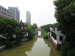
Pinghu is located on a low and flat plain and is laced with a network of rivers. A number of islands,such as Wangpan Shan are located offshore. The municipality's average yearly temperature is 15 °C (59 °F),with average precipitation of 1,186 mm (46.7 in). [6] Agricultural production is marked by its amount of aquatic products. Important crops are rice,wheat,Chinese cabbage,prawns,and bird eggs. Specialties include pickled eggs and watermelons. [7] Due to its proximity to Shanghai,Pinghu also attracts investment from many multinational enterprises. Industry includes clothing,packaging,machinery,paper and others. Clothing production is especially high,with the value of Pinghu's total clothing exports the greatest in China. It has been placed as one of China's one hundred most productive areas. [8]
Zhapu harbor in the municipality's southwest is an important deep water harbor along Hangzhou Bay. A port has been located here since the Tang dynasty,and it is still an important transshipment point. Next to the harbor is one of China's most important large thermal power plants,Jiaxing Powerplant,with a capacity of 3,000,000 kilowatts.
In modern China many famous monks,educators and artists (music,calligraphy,painting,seals,poetry) have come from Pinghu. The city's downtown contains a large memorial to Li Shutong and a number of other attractions and scenic spots. [9]
Climate data for Pinghu (1991–2020 normals,extremes 1981–2010) | |||||||||||||
---|---|---|---|---|---|---|---|---|---|---|---|---|---|
Month | Jan | Feb | Mar | Apr | May | Jun | Jul | Aug | Sep | Oct | Nov | Dec | Year |
Record high °C (°F) | 21.4 (70.5) | 26.9 (80.4) | 30.0 (86.0) | 31.4 (88.5) | 33.4 (92.1) | 36.3 (97.3) | 38.7 (101.7) | 38.5 (101.3) | 36.7 (98.1) | 32.8 (91.0) | 27.8 (82.0) | 23.6 (74.5) | 38.7 (101.7) |
Mean daily maximum °C (°F) | 8.3 (46.9) | 10.1 (50.2) | 14.0 (57.2) | 19.4 (66.9) | 24.3 (75.7) | 27.3 (81.1) | 32.0 (89.6) | 31.7 (89.1) | 27.9 (82.2) | 23.0 (73.4) | 17.4 (63.3) | 11.2 (52.2) | 20.5 (69.0) |
Daily mean °C (°F) | 4.5 (40.1) | 6.3 (43.3) | 10.0 (50.0) | 15.3 (59.5) | 20.5 (68.9) | 24.1 (75.4) | 28.6 (83.5) | 28.4 (83.1) | 24.2 (75.6) | 18.8 (65.8) | 13.2 (55.8) | 6.9 (44.4) | 16.7 (62.1) |
Mean daily minimum °C (°F) | 1.4 (34.5) | 3.1 (37.6) | 6.7 (44.1) | 11.8 (53.2) | 17.3 (63.1) | 21.6 (70.9) | 25.9 (78.6) | 25.8 (78.4) | 21.1 (70.0) | 15.0 (59.0) | 9.3 (48.7) | 3.3 (37.9) | 13.5 (56.3) |
Record low °C (°F) | −8.4 (16.9) | −7.0 (19.4) | −4.1 (24.6) | −1.0 (30.2) | 6.3 (43.3) | 12.2 (54.0) | 18.4 (65.1) | 17.2 (63.0) | 10.2 (50.4) | 1.2 (34.2) | −3.1 (26.4) | −9.3 (15.3) | −9.3 (15.3) |
Average precipitation mm (inches) | 80.2 (3.16) | 76.3 (3.00) | 109.8 (4.32) | 91.8 (3.61) | 112.6 (4.43) | 228.0 (8.98) | 141.2 (5.56) | 202.0 (7.95) | 117.3 (4.62) | 65.8 (2.59) | 67.2 (2.65) | 57.0 (2.24) | 1,349.2 (53.11) |
Average precipitation days (≥0.1 mm) | 12.1 | 11.4 | 13.9 | 12.7 | 12.3 | 14.9 | 11.6 | 12.7 | 10.7 | 7.6 | 9.8 | 9.1 | 138.8 |
Average snowy days | 3.0 | 2.3 | 0.7 | 0.1 | 0 | 0 | 0 | 0 | 0 | 0 | 0.2 | 1.1 | 7.4 |
Average relative humidity (%) | 79 | 78 | 78 | 77 | 78 | 84 | 80 | 80 | 81 | 79 | 79 | 77 | 79 |
Mean monthly sunshine hours | 113.7 | 117.9 | 140.1 | 165.1 | 178.7 | 137.5 | 229.9 | 227.0 | 178.3 | 174.7 | 137.6 | 130.0 | 1,930.5 |
Percent possible sunshine | 35 | 37 | 38 | 43 | 42 | 33 | 54 | 56 | 49 | 50 | 44 | 41 | 44 |
Source:China Meteorological Administration [10] [11] |
Jiaxing,alternately romanized as Kashing,is a prefecture-level city in northern Zhejiang province,China. Lying on the Grand Canal of China,Jiaxing borders Hangzhou to the southwest,Huzhou to the west,Shanghai to the northeast,and the province of Jiangsu to the north. As of the 2020 census,its population was 5,400,868 and its built-up area made of 2 urban districts was home to 1,518,654 inhabitants.
Tongxiang City is a county-level city,part of Jiaxing,in northern Zhejiang Province,China,bordering Jiangsu province to the north. It had a population of 1,029,754 as of the 2020 census even though its built-up area is smaller. Nevertheless,as the city is expanding east quickly,its now nearly conurbated with Jiaxing built-up area by Xiuzhou District.
Jiashan County is a county in the north of Zhejiang Province,bordering Shanghai to the northeast and Jiangsu province to the north. It is administered by the prefecture-level city of Jiaxing. Jiashan is nicknamed "The Land of Fish and Rice",and is 80 km (50 mi) southwest of central Shanghai,95 km (59 mi) east of Hangzhou,and 90 km (56 mi) south of Suzhou. The county seat is located on 126 People Avenue,Weitang Town.
is a county lying in the northeastern Fujian province,People's Republic of China. It is under the administration of Ningde City and is located in the southwest part of the municipality. It is also known as "the town of the former worthy",as Zhu Xi,a famous Chinese scholar once lived there. It is also known as Kutien or Kucheng.
Huainan is a prefecture-level city with 3,033,528 inhabitants as of the 2020 census in north-central Anhui province,China. It is named for the Han-era Principality of Huainan. It borders the provincial capital of Hefei to the south,Lu'an to the southwest,Fuyang to the west,Bozhou to the northwest,Bengbu to the northeast and Chuzhou to the east. Huainan is one of the core cities of Hefei Metropolitan Circle and is known for its coal industry and thermal power plants. Its built-up area made of 4 urban districts and Fengtai County largely being urbanized,was home to 1,868,944 inhabitants as of 2020. Its city flower is the Chinese rose and its city tree is the Old-World Plane Tree. It is also considered to be the hometown and birthplace of tofu.
Dingxi,also known as Longyou is a prefecture-level city in the southeast of Gansu province,People's Republic of China. As of the 2020 census,its population was 2,524,097 inhabitants,of which 422,383 lived in the built-up area made of Anding urban district.
Wuwei is a prefecture-level city in northwest central Gansu province. In the north it borders Inner Mongolia,in the southwest,Qinghai. Its central location between three western capitals,Lanzhou,Xining,and Yinchuan makes it an important business and transportation hub for the area. Because of its position along the Hexi Corridor,historically the only route from central China to western China and the rest of Central Asia,many major railroads and national highways pass through Wuwei.
Rongcheng is a county-level city of the prefecture-level city of Weihai,at the eastern extremity of Shandong Province,China,looking out to the Yellow Sea in all directions but the west.
is a county-level city in Zhejiang Province,China,and under the jurisdiction of Jiaxing. It is in the south side of Yangtze River Delta,and in the north of Zhejiang. It is 125 km (78 mi) to the southwest of central Shanghai,and 61.5 km (38.2 mi) east of Hangzhou,the provincial capital. To its south lies the Qiantang River. The city has a land area of 700.5 km2 (270.5 sq mi) and as of the 2020 census,had a population of 1,076,199 inhabitants. Haining is known for its leather industry and spectacular tide in the Qiantang River. Since June 2021,it's linked to Hangzhou by the new suburban Hangzhou - Haining subway Line.
,formerly known as Xihaigu,is a prefecture-level city in the Ningxia Hui Autonomous Region of the People's Republic of China. It occupies the southernmost section of the region,bordering Gansu province to the east,south,and due west. This is also the site of Mount Sumeru Grottoes (须弥山),which is among the ten most famous grottoes in China. As of the end of 2018,the total resident population in Guyuan was 1,124,200.
Pingtang County is a county in the Qiannan Buyei and Miao Autonomous Prefecture of Guizhou province,China,bordering Guangxi to the south. It is a high mountain valley and is inhabited mainly by members of the Buyei and Miao ethnic minorities,who together make up 55% of the county's population.
Haiyan County is a county under the administration of Jiaxing City,in the north of Zhejiang province,China,situated on the north shore of Hangzhou Bay and includes the north end of the Hangzhou Bay Bridge.
Chun'an is a county of Zhejiang Province,East China,it is under the administration of the prefecture-level city of Hangzhou,the capital of Zhejiang,containing the well-known Qiandao Lake and bordering Anhui province to the northwest. It has a land area of 4,452 km2 (1,719 sq mi) and a population of 450,000. The postal code is 311700,and the county seat is located on 18 North Xin'an Rd.,Qiandaohu Town.
Qing'an County is a county of west-central Heilongjiang province,People's Republic of China. It is under the jurisdiction of the prefecture-level city of Suihua.
Pingshan County is a county located in southern Sichuan Province,China,bordering Yunnan province to the south. It is under the administration of Yibin city. It is on the route of China National Highway 213 and Sichuan Provincial Highway 307. As of 2012,there are 131 primary schools and 22 secondary schools in the county. There are 17 hospitals and clinics in the county. The county oversees eight towns and seven townships.
Shengsi County is a county in the northeast of Zhejiang province consisting of an archipelago islands located to the east of Hangzhou Bay. It is under the administration of Zhoushan City and is the easternmost county-level division in the province. The islands of Greater and Lesser Yangshan are connected with Shanghai's Pudong New Area by the Donghai Bridge and their port forms part of the Port of Shanghai. They are,however,not counted among the islands of Shanghai.
Guangshan County is a county in the southeast of Henan province,China. It is under the administration of Xinyang city. The regional dialect is the Xinyang city dialect of Southwestern Mandarin.
Shuangyang District is one of seven districts of the prefecture-level city of Changchun,the capital of Jilin Province,Northeast China,forming part of the city's southeastern suburbs. Despite its name,it lies more than 40 kilometres (25 mi) southeast of the urban centre. It borders the districts of Erdao to the north and Nanguan to the northwest,as well as the prefecture-level cities of Jilin to the south and east and Siping to the southwest.
Alxa Left Banner is a banner in the southwest of Inner Mongolia,China. It borders Mongolia's Ömnögovi Province to the north,the autonomous region of Ningxia to the southeast,and Gansu province to the southwest. The town of Bayanhot,situated in the banner,is the seat of government of the greater Alxa League,of which Alxa Left Banner is a part.
Zhapu,alternately romanized as Chapoo or Chapu,is a town under the administration of Pinghu,in the north of Zhejiang Province,China. It is located along the northern shore of Hangzhou Bay in the southeastern part of Pinghu and borders Haiyan County to its south and southeast. The town covers an area of 54.4 square kilometers and has a population of 54,000.