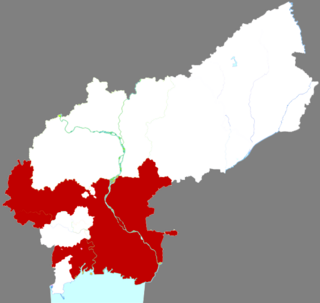
Jiutai is one of seven districts of the prefecture-level city of Changchun,the capital of Jilin Province,Northeast China. The district is surrounded by agricultural areas and is located around 50 kilometres (31 mi) northeast of downtown Changchun. Coal mining also is present in Jiutai. It borders Dehui to the north,Erdao District to the southwest,Kuancheng District to the west,as well as the prefecture-level city of Jilin to the south and east.

Renqiu is a county-level city in Hebei province,China. It is located 79 kilometres (49 mi) northwest of the prefecture-level city of Cangzhou,which administers it,and 104 kilometres (65 mi) southwest of Tianjin. It is the location of North China Oil Field.

Yushu is a county-level city of Jilin Province,Northeast China,it is under the administration of the prefecture-level city of Changchun. It is more than 140 kilometres (87 mi) to the northeast of central Changchun,and around 100 kilometres (62 mi) south of Harbin. The name of the place means "Elm Tree". The northernmost county-level division of Changchun,it borders Dehui to the southwest as well as the prefecture-level division of Harbin (Heilongjiang) to the northeast.

is a county located in central Fujian province,People's Republic of China. It is under the administration of Quanzhou City and covers an area of 2,232 square kilometres (862 sq mi) with a total population of 300,000.
Queshan County is a county under the prefecture-level city of Zhumadian,Henan Province,China.
Longshan County is a county of Hunan Province,China,it is under the administration of Xiangxi Autonomous Prefecture.

Longquan is a county-level city and former county under the administration of the prefecture-level city of Lishui in southwestern Zhejiang Province,China,located on the upper reaches of the Ou River and bordering Fujian province to the southwest.

Wenshan is a city in and the seat of Wenshan Zhuang and Miao Autonomous Prefecture,in the southeast of Yunnan province,People's Republic of China. It once was a county,but on 2 December 2010,with the approval of the PRC State Council,it was upgraded to a county-level city.

Tiantai County is located in Taizhou,Zhejiang,People's Republic of China. Residents mainly speak the Tiantai dialect.

Shaxian District,formerly Sha County,is a District of Sanming,Fujian Province,People's Republic of China. Shaxian District is the hometown of Shaxian delicacies,which are considered part of the food heritage of China.

Zhangping is a city in the southwest of Fujian province,People's Republic of China. It is under the administration of the prefecture-level city of Longyan.

County is a county in the east of Zhejiang province,China. It is under the administration of the city of Ningbo.

Xianju County is a county of Zhejiang,China. It is under the administration of the Taizhou city. It is the location of Shenxianju,a geological site protected by the Chinese government. Xianju is an economically underdeveloped county,relying somewhat on tourism. On October 15,Shenxianju scenic spot became a national 5A level scenic spot.
Yunhe County is a county in the southwest of Zhejiang province,China. It is under the administration of the Lishui city.

Lingling District is one of two urban districts of Yongzhou City,Hunan Province,China. It is located on the south of the city proper,and lies to the eastern border of Guangxi.

Shuangyang District is one of seven districts of the prefecture-level city of Changchun,the capital of Jilin Province,Northeast China,forming part of the city's southeastern suburbs. Despite its name,it lies more than 40 kilometres (25 mi) southeast of the urban centre. It borders the districts of Erdao to the north and Nanguan to the northwest,as well as the prefecture-level cities of Jilin to the south and east and Siping to the southwest.

Panshi is a city of south-central Jilin province of Northeast China. It is under the administration of Jilin City.

Gaizhou,formerly Gaixian,Gaiping,and Kaiping,is a county-level city in Liaoning province,China. It is under the administration of Yingkou City,which lies 31 km (19 mi) to the north-northwest,and is located at the northwest end of the Liaodong Peninsula near the northeast coast of the Bohai Sea.

Linghai is a county-level city in the west of Liaoning province,Northeast China. It was called Jinxian or Jin County until 1993,when it was reorganized to a county-level city and renamed Linghai. With its urban core lying on the west (right) bank of the Daling River,which flows into Liaodong Bay near the city,it is under the administration of the prefecture-level city of Jinzhou,the seat of which is 21 kilometres (13 mi) to the southwest.

Qujiang District,formerly Qu County,is a district of Quzhou City,Zhejiang,China.


