Yuxi

Last updated • 3 min readFrom Wikipedia, The Free Encyclopedia
Yuxi
玉溪市
Yuxi.jpg
Yuxi in Yunnan.svg
Location of Yuxi in Yunnan
Coordinates(Yuxi municipal government): 24°20′49″N102°31′37″E / 24.347°N 102.527°E / 24.347; 102.527
Country People's Republic of China
Province Yunnan
Admin HQ Hongta
Area
  Total15,285 km2 (5,902 sq mi)
Population
  Total2,568,000
  Density170/km2 (440/sq mi)
GDP [1]
  Total CN¥ 252 billion
US$ 37.2 billion
  Per capitaCN¥ 111,579
US$16,457
Time zone UTC+8 (China Standard)
Postal code
653100
Area code 0877
ISO 3166 code CN-YN-04
License Plate Prefix云F
Website www.yuxi.gov.cn (in Chinese)
Yunnan e-Portal

Yuxi (Chinese :玉溪; pinyin :Yùxī) is a prefecture-level city in the central part of Yunnan province of the People's Republic of China. The administrative center of Yuxi is Hongta District. Yuxi is approximately 90 kilometres (56 mi) south of Kunming.

Contents

Geography

Yuxi is located in the center of Yunnan province, about 90 kilometres (56 mi) south of Kunming, the provincial capital. Like much of the central and eastern parts of the province, it is part of the Yunnan-Guizhou Plateau.

The area is 15,285 km2 (5,902 sq mi) and the population is approximately 2.5 million.

Near Yuxi city is Fuxian Lake, the second-deepest freshwater lake in China, where there have been discovered ancient fossils that are now in the possession of the Yuxi museum. There also are three other lakes around the city. They are Xingyun Lake, Qilu Lake, Yangzong Lake.

Climate

Tempered by the low latitude and moderate elevation, Yuxi has a mild subtropical highland climate (Köppen Cwb), with short, mild, dry winters, and warm, rainy summers. Frost may occur in winter but the days still generally warm up to around 17 °C (63 °F). During summer, a majority of the days features some rainfall, and daytime temperatures rise to 26 °C (79 °F). A great majority of the year's rainfall occurs from June to October.

Climate data for Yuxi, elevation 1,717 m (5,633 ft), (1991–2020 normals, extremes 1971–2010)
MonthJanFebMarAprMayJunJulAugSepOctNovDecYear
Record high °C (°F)24.1
(75.4)
27.7
(81.9)
29.2
(84.6)
32.4
(90.3)
32.6
(90.7)
31.7
(89.1)
31.3
(88.3)
31.0
(87.8)
30.9
(87.6)
29.1
(84.4)
26.4
(79.5)
25.2
(77.4)
32.6
(90.7)
Mean daily maximum °C (°F)17.4
(63.3)
19.8
(67.6)
23.2
(73.8)
25.8
(78.4)
26.8
(80.2)
26.8
(80.2)
26.2
(79.2)
26.2
(79.2)
24.9
(76.8)
22.6
(72.7)
20.0
(68.0)
17.2
(63.0)
23.1
(73.5)
Daily mean °C (°F)10.1
(50.2)
12.2
(54.0)
15.6
(60.1)
18.5
(65.3)
20.6
(69.1)
21.7
(71.1)
21.2
(70.2)
20.8
(69.4)
19.5
(67.1)
17.1
(62.8)
13.2
(55.8)
10.2
(50.4)
16.7
(62.1)
Mean daily minimum °C (°F)4.5
(40.1)
5.9
(42.6)
9.0
(48.2)
12.2
(54.0)
15.6
(60.1)
18.1
(64.6)
18.1
(64.6)
17.6
(63.7)
16.2
(61.2)
13.6
(56.5)
8.7
(47.7)
5.5
(41.9)
12.1
(53.8)
Record low °C (°F)−4.4
(24.1)
−2.2
(28.0)
−2.5
(27.5)
3.4
(38.1)
6.6
(43.9)
12.0
(53.6)
12.2
(54.0)
10.7
(51.3)
7.0
(44.6)
2.9
(37.2)
−0.9
(30.4)
−5.5
(22.1)
−5.5
(22.1)
Average precipitation mm (inches)27.7
(1.09)
14.2
(0.56)
19.5
(0.77)
35.1
(1.38)
77.8
(3.06)
138.0
(5.43)
179.8
(7.08)
168.7
(6.64)
90.2
(3.55)
74.8
(2.94)
37.5
(1.48)
16.2
(0.64)
879.5
(34.62)
Average precipitation days (≥ 0.1 mm)4.83.65.17.711.614.819.519.013.611.95.34.3121.2
Average snowy days0.40.10.1000000000.10.7
Average relative humidity (%)70625657647479807878767571
Mean monthly sunshine hours 204.3212.6236.9238.6208.1140.1105.4118.5109.6127.4170.3173.22,045
Percent possible sunshine 61666362503425303036525347
Source 1: China Meteorological Administration [2] [3]
Source 2: Weather China [4]

Transport

History

The city was founded in 960 AD, at a time when Yunnan was not yet part of China. Yuxi was once the core area of Yunnan Province during the pre-Qin period (period before 221 BC). In the Western Han dynasty (206 BC-24 AD), it became a county of Yizhou Shire. The following dynasties witnessed the continuous separations and unifications of the area. It was not until 1997 that Yuxi became a prefecture-level city of the People's Republic of China. [5]

Demography

Among the resident population, the Han population is 1,560,279, accounting for 67.73% of the total population; the ethnic minorities population is 743,232, accounting for 32.27% of the total population.

Ethnic Composition of Yuxi City (November 2010) [6]
民族名称 Han Yi Hani Dai Hui Bai Miao Mongol Lahu Zhuang Others
Population1560281446997130284735964828411822103067139702723665416
Proportion of total population (%)67.7319.405.663.192.100.510.450.310.310.100.24
Proportion of minority population (%)---60.1417.539.906.501.591.390.960.950.320.73

Government

Rao Nanhu is the mayor of Yuxi City.

People

The composer of China's National Anthem, Nie Er was from Yuxi.

Economy

A distant view of the Hongta Group Headquarters (Hongta cigarette company) Hongta Group.jpg
A distant view of the Hongta Group Headquarters (Hongta cigarette company)

Yuxi is the home of the Hongta Group, which was named after the Red Pagoda which sits atop a nearby hill. The Pagoda was originally white, but was painted red during the cultural revolution. The tobacco is of high quality because there are over 2300 hours of sunlight a year in the region, adequate rainfall in the summer, and excellent soil that produces a plethora of other fruits and vegetables. The region has begun producing wine, which could prove to be quite palatable in the next decade or so. There are substantial mineral deposits of tin and phosphate ores, including the Heavenly Triangle of Huaning, [7] Jiangchuan and Chengjiang.

Yuxi is one of the fastest growing small cities in China. In 2001, the city won an Honor Award in Analysis & Planning by the American Society of Landscape Architects. In 2004 UNIDO held a Workshop on Seed Treatment Technology, one of only two in China.

Education

Yuxi Normal University is a university located in Yuxi with almost 8000 students. It was founded in 1978 as Yuxi Normal College. In 2000, under the approval from the Ministry of Education of the People's Republic of China, it was renamed Yuxi Normal University, with the merging of Yuxi Adult Education Center and Yuxi Normal School.

Subdivisions

Map
Name Hanzi Hanyu Pinyin Population
(2010)
Area (km2)Density
(/km2)
Hongta District 红塔区Hóngtǎ Qū495,1291,004493
Jiangchuan District 江川区Jiāngchuān Qū280,889850330
Chengjiang 澄江市Chéngjiāng shì169,366773219
Tonghai County 通海县Tōnghǎi Xiàn300,800721417
Huaning County 华宁县Huáníng Xiàn214,6501,313163
Yimen County 易门县Yìmén Xiàn177,1101,571113
Eshan Yi Autonomous County 峨山彝族自治县Éshān Yízú Zìzhìxiàn162,8311,97283
Xinping Yi and Dai Autonomous County 新平彝族傣族自治县Xīnpíng Yízú Dǎizú Zìzhìxiàn285,3444,22368
Yuanjiang Hani, Yi and Dai Autonomous County 元江哈尼族彝族傣族自治县Yuánjiāng Hānízú Yízú Dǎizú Zìzhìxiàn217,3922,85876

See also

Related Research Articles

<span class="mw-page-title-main">Dali City</span> City in Yunnan, China

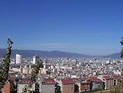
Dali City is the county-level seat of the Dali Bai Autonomous Prefecture in northwestern Yunnan. Dali City is administered through 12 township-level districts, two of which are also commonly referred to as Dali.

<span class="mw-page-title-main">Shangrao</span> Prefecture-level city in Jiangxi, Peoples Republic of China

Shangrao is a medium-sized prefecture-level city located in the northeast of Jiangxi province, People's Republic of China. The city borders the province of Anhui to the north, the province of Zhejiang to the east, and the province of Fujian to the south. Also, the city's western reaches extend into Poyang Lake. Shangrao had a population of 6,491,088 as of 2020 census whom 1,293,399 lived in the built up area made of Xinzhou and Guangxin districts, Guangfeng District not being conurbated yet. Shangrao itself is at the very western edge of the Wu-speaking areas, while most of its associated counties speak Gan.

<span class="mw-page-title-main">Lincang</span> Prefecture-level city in Yunnan, Peoples Republic of China

Lincang is a prefecture-level city located in the southwest of Yunnan province, People's Republic of China.

<span class="mw-page-title-main">Pu'er City</span> Prefecture-level city in Yunnan, Peoples Republic of China

Pu'er is a prefecture-level city in southern Yunnan Province, China. The urban administrative center of Pu'er is Simao District, which is also the former name of the prefecture-level city itself. A major downturn in the price of tea in 2007 caused severe economic distress in the area. The price of Pu'er has since recovered and Pu'er tea, a type of dark tea, still contributes much to the income of the area.

<span class="mw-page-title-main">Neijiang</span> Prefecture-level city in Sichuan, Peoples Republic of China

Neijiang is a prefecture-level city in the southeast of Sichuan province, People's Republic of China. It is located on the Tuo River, midway between the two major cities of Chengdu and Chongqing, is a transportation and food-processing center. The population of the entire prefecture was 3,140,678 at the 2020 census, and the population of the built-up (metro) area was 1,179,140 in the 2 urban districts of Shizhong and Dongxing.

<span class="mw-page-title-main">Guangyuan</span> Prefecture-level city in Sichuan, Peoples Republic of China

Guangyuan is a prefecture-level city in Sichuan Province, China, bordering the provinces of Shaanxi to the northeast and Gansu to the northwest. The city has a population of 2,305,657 as of the 2020 census.

<span class="mw-page-title-main">Mengzi City</span> County-level city in Yunnan, China

Mengzi is a city in the southeast of Yunnan Province, China. Administratively, it is a county-level city and the prefectural capital of the Honghe Hani and Yi Autonomous Prefecture, located about 243 kilometres (151 mi) southeast from Kunming, and 400 kilometres northwest from Hanoi, Vietnam. It is situated in the centre of a fertile valley basin on the Yunnan-Guizhou Plateau 1,310 metres (4,300 ft) above the sea level and was home to about 590,300 inhabitants as of 2021 census. Mengzi was formerly Mengzi County (蒙自县) until October 2010, when it was upgraded to a county-level city. Mengzi is the core area of South Yunnan Central City Cluster, which is officially regarded as the political, economic, cultural, and military centre of South Yunnan.

<span class="mw-page-title-main">Baoshan, Yunnan</span> Prefecture-level city in Yunnan, Peoples Republic of China

Baoshan, historically also Yongchang, is a prefecture-level city in western Yunnan Province, People's Republic of China. Baoshan is the second-biggest metropolitan area in western Yunnan after Dali.

<span class="mw-page-title-main">Zhaotong</span> Prefecture-level city in Yunnan, Peoples Republic of China

Zhaotong is a prefecture-level city located in the northeast corner of Yunnan province, China, bordering the provinces of Guizhou to the south and southeast and Sichuan to the northeast, north, and west.

<span class="mw-page-title-main">Qujing</span> Prefecture-level city in Yunnan, Peoples Republic of China

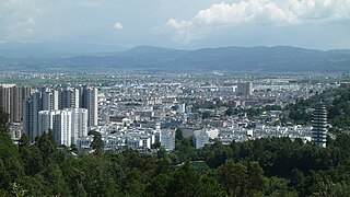
Qujing is a prefecture-level city in the east of Yunnan province, China, bordering Guizhou province to the east and the Guangxi Zhuang Autonomous Region to the southeast; thus, it was called "Key between Yunnan and Guizhou" (滇黔锁钥) and "Throat of Yunnan" (云南咽喉) in the past. It is part of the Central Yunnan Metropolitan Region plan (滇中城市群规划) in effect for 2016–49. Its administrative population is 6,047,000 according to a 2015 estimate, of whom, 1,408,500 reside in the metro area, which contains Qilin District, Zhanyi District and Malong District. During the 11th National Five-Year Plan period, the government of Qujing planned to develop the city into the "big city at the origin of the Pearl River" (珠江源大城市) in the following decades, including increasing the built-up urban area to past 100 km2 (39 sq mi) and the urban population to surpass 1 million by 2020, the second in Yunnan, after Kunming.

<span class="mw-page-title-main">Xinyu</span> Prefecture-level city in Jiangxi, Peoples Republic of China

Xinyu, is a prefecture-level city in west-central Jiangxi province, People's Republic of China.

<span class="mw-page-title-main">Chuxiong City</span> County-level city in Yunnan, China

Chuxiong City is a county-level city and the capital of the Chuxiong Yi Autonomous Prefecture, in Central Yunnan Province, China.

<span class="mw-page-title-main">Shiping County</span> County in Yunnan, Peoples Republic of China

Shiping County is a county in the Honghe Hani and Yi Autonomous Prefecture in the southern part of the Yunnan province, China. It is located about 240 km (150 mi) from Kunming, the provincial capital. The county has a population of approximately 280,000 and its area is 3,037 km2 (1,173 sq mi).

<span class="mw-page-title-main">Mangshi</span> County-level city in Yunnan, China

Mangshi, former name Luxi (潞西), is a county-level city and the seat of Dehong Dai and Jingpo Autonomous Prefecture, western Yunnan province, China. Mangshi has an area of 2,900.91 km2 (1,120.05 sq mi), with an urban area of 18.66 km2 (7.20 sq mi). Han Chinese, Dai people and Jingpo people are the major ethnic groups. Luxi County was founded in 1949, and became a county-level city in 1996.

<span class="mw-page-title-main">Tonghai County</span> County in Yunnan, Peoples Republic of China

Tonghai County is located in Yuxi Prefecture-level City, Yunnan Province, China.

<span class="mw-page-title-main">Eshan Yi Autonomous County</span> Autonomous county in Yunnan, China

Eshan Yi Autonomous County is located in Yuxi, in the central part of Yunnan Province, China.

<span class="mw-page-title-main">Xinping Yi and Dai Autonomous County</span> Autonomous county in Yunnan, China

Xinping Yi and Dai Autonomous County is an autonomous county located in the central part of Yunnan Province, China. It is the westernmost county-level division of the prefecture-level city of Yuxi.

<span class="mw-page-title-main">Heqing County</span> County in Yunnan, China

Heqing County is a county in the Dali Bai Autonomous Prefecture located in the northwest of Yunnan Province, China.

<span class="mw-page-title-main">Pingbian Miao Autonomous County</span> Autonomous county in Yunnan, China

Pingbian Miao Autonomous County is a county located in Honghe Hani and Yi Autonomous Prefecture in the southeast of Yunnan province, China. Its seat is located only 21 kilometres (13 mi) from the border with Lào Cai Province, Vietnam.

<span class="mw-page-title-main">Mengla County</span> County in Yunnan, China

Mengla County is a county under the jurisdiction of the Xishuangbanna Dai Autonomous Prefecture, in far southern Yunnan province, China. Meng is a variation of Mueang.

References

  1. 云南省统计局、国家统计局云南调查总队 (December 2023). 《云南统计年鉴-2023》. 中国统计出版社. ISBN   978-7-5037-9653-1.
  2. 中国气象数据网 – WeatherBk Data (in Simplified Chinese). China Meteorological Administration . Retrieved 10 April 2023.
  3. "Experience Template" 中国气象数据网 (in Simplified Chinese). China Meteorological Administration . Retrieved 10 April 2023.
  4. 玉溪 - 气象数据 -中国天气网 (in Chinese). Weather China. Retrieved 21 November 2022.
  5. "Yuxi Travel Guide".
  6. Yunnan Provincial Census Office, Yunnan Provincial Bureau of Statistics (September 2012). "Yunnan Provincial Census Data in 2010". China Statistics Press. ISBN   978-7-5037-6548-3.
  7. "USGS Mineral Set, 2002" (PDF).