Zhenxiong County 镇雄县 | |
---|---|
![]() Zhenxiong County, in Zhaotong City, Yunnan Province, China | |
![]() Location of Zhenxiong County (red) in Zhaotong City (pink) and Yunnan Province | |
Coordinates: 27°27′N104°52′E / 27.450°N 104.867°E | |
Country | People's Republic of China |
Province | Yunnan |
Prefecture-level city | Zhaotong |
Township-level divisions | 16 towns 10 townships 2 ethnic townships |
County seat | Wufeng Town (乌峰镇) |
Area | |
• Total | 3,785 km2 (1,461 sq mi) |
• Land | 3,785 km2 (1,461 sq mi) |
Elevation | 1,684 m (5,525 ft) |
Population (2020) [1] | |
• Total | 1,349,795 |
• Density | 360/km2 (920/sq mi) |
Time zone | UTC+8 (China Standard Time) |
Postal code | 657200 |
Area code | 0870 |
Website | http://www.zx.gov.cn/ |
Zhenxiong County (simplified Chinese :镇雄县; traditional Chinese :鎮雄縣; pinyin :Zhènxióng Xiàn) is a county in the northeast of Yunnan province, China, under the administration of Zhaotong prefecture and bordering Guizhou and Sichuan.
Zhengxiong County is located in the northeastern part of Yunnan province. It has an area of 3,785 square kilometres (1,461 sq mi), [1] a latitude ranging from 27° 17' to 27° 50' N and a longitude ranging from 104° 18' to 105° 19' E. The county has a maximum north-south extent of 54 km (34 mi) and a maximum east-west width of 99 km (62 mi). It borders Xuyong County (Sichuan) to the east across the Chishui River, Hezhang County (Guizhou) to the south, Yiliang County to the west, and Weixin County to the north. The village of Delong (德隆村) in Potou Township (坡头乡) is located near the triple intersection point of the three provinces, and is so nicknamed the "fowl cry of the three provinces" (鸡鸣三省). By road, the prefectural seat of Zhaotong is 265 km (165 mi) to the west, provincial capital Kunming is 598 km (372 mi) to the southwest, Guiyang is 326 km (203 mi) to the southeast, Chongqing is 505 km (314 mi) to the northeast, and Chengdu 618 km (384 mi) to the north-northwest.
Zhenxiong is located amongst the northern slopes of the Yunnan–Guizhou Plateau, with elevations increasing from northeast to southwest, although the central and southern areas are more level. Elevations range from 2,416 m (7,927 ft) at Mount Jiayao (戛么山), in the village of Maiche (麦车村), An'er Township (安尔乡), down to 630 m (2,070 ft) in the village of Tongping (桐坪村), Luokan Town (罗坎镇). Most of the county has a subtropical highland climate; the annual mean is 11.3 °C (52.3 °F), sunshine totals 1,341 hours annually, the frost-free period is 218.6 days, and annual precipitation averages 914.6 millimetres (36.01 in).
Climate data for Zhenxiong, elevation 1,645 m (5,397 ft), (1991–2020 normals, extremes 1981–2010) | |||||||||||||
---|---|---|---|---|---|---|---|---|---|---|---|---|---|
Month | Jan | Feb | Mar | Apr | May | Jun | Jul | Aug | Sep | Oct | Nov | Dec | Year |
Record high °C (°F) | 28.5 (83.3) | 28.5 (83.3) | 32.6 (90.7) | 32.0 (89.6) | 34.8 (94.6) | 32.0 (89.6) | 32.7 (90.9) | 33.5 (92.3) | 33.7 (92.7) | 29.2 (84.6) | 26.6 (79.9) | 23.6 (74.5) | 34.8 (94.6) |
Mean daily maximum °C (°F) | 6.0 (42.8) | 9.5 (49.1) | 14.0 (57.2) | 18.9 (66.0) | 21.7 (71.1) | 23.4 (74.1) | 26.1 (79.0) | 25.8 (78.4) | 22.4 (72.3) | 16.8 (62.2) | 13.4 (56.1) | 7.6 (45.7) | 17.1 (62.8) |
Daily mean °C (°F) | 1.8 (35.2) | 4.3 (39.7) | 8.3 (46.9) | 13.0 (55.4) | 16.1 (61.0) | 18.4 (65.1) | 20.7 (69.3) | 20.2 (68.4) | 17.2 (63.0) | 12.5 (54.5) | 8.4 (47.1) | 3.4 (38.1) | 12.0 (53.6) |
Mean daily minimum °C (°F) | −0.3 (31.5) | 1.6 (34.9) | 4.9 (40.8) | 9.2 (48.6) | 12.3 (54.1) | 15.2 (59.4) | 17.0 (62.6) | 16.4 (61.5) | 13.9 (57.0) | 10.1 (50.2) | 5.7 (42.3) | 1.1 (34.0) | 8.9 (48.1) |
Record low °C (°F) | −8.9 (16.0) | −7.5 (18.5) | −6.3 (20.7) | −0.8 (30.6) | 1.4 (34.5) | 7.9 (46.2) | 7.2 (45.0) | 8.5 (47.3) | 4.5 (40.1) | −1.4 (29.5) | −4.2 (24.4) | −11.2 (11.8) | −11.2 (11.8) |
Average precipitation mm (inches) | 16.8 (0.66) | 15.9 (0.63) | 26.4 (1.04) | 53.0 (2.09) | 81.4 (3.20) | 145.8 (5.74) | 175.0 (6.89) | 158.5 (6.24) | 92.5 (3.64) | 63.2 (2.49) | 21.3 (0.84) | 14.9 (0.59) | 864.7 (34.05) |
Average precipitation days (≥ 0.1 mm) | 19.1 | 16.2 | 16.6 | 16.2 | 17.7 | 19.6 | 17.8 | 16.7 | 16.3 | 19.1 | 14.4 | 18.5 | 208.2 |
Average snowy days | 10.0 | 6.2 | 2.4 | 0.1 | 0 | 0 | 0 | 0 | 0.1 | 0.2 | 1.0 | 5.8 | 25.8 |
Average relative humidity (%) | 87 | 84 | 81 | 78 | 79 | 83 | 81 | 81 | 83 | 87 | 85 | 87 | 83 |
Mean monthly sunshine hours | 53.2 | 75.3 | 106.6 | 128.0 | 124.1 | 100.5 | 156.0 | 152.9 | 110.8 | 70.0 | 83.0 | 60.0 | 1,220.4 |
Percent possible sunshine | 16 | 24 | 29 | 33 | 30 | 24 | 37 | 38 | 30 | 20 | 26 | 19 | 27 |
Source: China Meteorological Administration [2] [3] |
Zhenxiong County consists of 3 districts, 20 towns, 5 townships, 2 ethnic townships: [4]
Level | № | Pinyin name | Simplified Chinese name |
---|---|---|---|
District | 1 | Wufeng District | 乌峰街道 |
2 | Nantai District | 南台街道 | |
3 | Jiufu District | 旧府街道 | |
Town | 1 | Poji Town | 泼机镇 |
2 | Heishu Town | 黑树镇 | |
3 | Muxiang Town | 母享镇 | |
4 | Dawan Town | 大湾镇 | |
5 | Yile Town | 以勒镇 | |
6 | Chishuiyuan Town | 赤水源镇 | |
7 | Mangbu Town | 芒部镇 | |
8 | Yuhe Town | 雨河镇 | |
9 | Rokan Town | 牛场镇 | |
10 | Niuchang Town | 牛场镇 | |
11 | Wude Town | 五德镇 | |
12 | Potou Town | 坡头镇 | |
13 | Yigu Town | 以古镇 | |
14 | Changba Town | 场坝镇 | |
15 | Tangfang Town | 塘房镇 | |
16 | Zhongtun Town | 中屯镇 | |
17 | Muzhuo Town | 木卓镇 | |
18 | Yanyuan Town | 盐源镇 | |
19 | Wanchang Town | 碗厂镇 | |
20 | Pingshang Town | 坪上镇 | |
Township | 1 | Yudong Township | 鱼洞乡 |
2 | Hualang Township | 花朗乡 | |
3 | Jianshan Township | 尖山乡 | |
4 | Shanshu Township | 杉树乡 | |
5 | Huashan Township | 花山乡 | |
Ethnic Township | 1 | Guozhu Yi Ethnic Township | 果珠彝族乡 |
2 | Linkou Yi and Miao Ethnic Township | 林口彝族苗族乡 |
Most people in Zhenxiong County speak Standard Chinese (commonly called "Mandarin"), which is used in the media, by the government, and as the language of instruction in education. A notable exception is the Yi people, who commonly speak the Yi language. The other significant minority group living in Zhenxiong County is the Miao people, who live at higher elevations in the county.
Zhenxiong possesses rich mineral resources (in total 30 types), including coal, pyrite, marble, and cryolite. Among them, coal and pyrite have a very wide distribution with richer reserves. The prospective reserves and industrial reserves of coal are 7.4 million tons and 4.517 million tons, respectively. The former accounts for 28.01% of provincial output, and the latter is about 17.1%.
The main road passing through Zhenxiong County is China Provincial Road (302 Shengdao), which is a shengdao or shoudou, or provincial road. Other important provincial roads include
(212 Shengdao) and
(324 Shengdao). China County Road
(252 Xiandao) and
(253 Xiandao) are important xiandao, or county-level roads that also pass through Zhenxiong County.
From Zhenxiong County, it is roughly 320 km to Guiyang, 500 km to Chongqing, 535 km to Chengdu, 570 km to Kunming, 900 km to Nanning, 1200 km to Xi'an, 1220 km to Guangzhou, 1330 km to Shenzhen, 1570 km to Lanzhou, 1790 km to Xiamen, and 2250 km to Beijing.
Guiyang is the capital of Guizhou province of the People's Republic of China. It is located in the center of the province, situated on the east of the Yunnan–Guizhou Plateau, and on the north bank of the Nanming River, a branch of the Wu River. The city has an elevation of about 1,100 meters (3,600 ft). It has an area of 8,034 square kilometers (3,102 sq mi). At the 2020 census, its population was 5,987,018, out of whom 4,506,134 lived in the six urban districts.
Yibin is a prefecture-level city in the southeastern part of Sichuan province, China, located at the junction of the Min and Yangtze Rivers. Its population was 4,588,804 inhabitants, according to the 2020 census, of whom 2,158,312 lived in the built-up area comprising three urban districts.
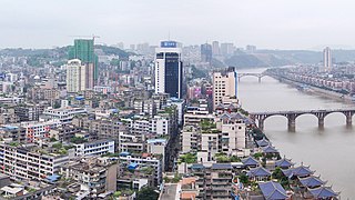
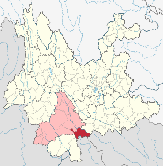
Luzhou (simplified Chinese: 泸州; traditional Chinese: 瀘州; pinyin: Lúzhōu; Sichuanese Pinyin: Nu2zou1; Luzhou dialect: ), formerly transliterated as Lu-chou or Luchow, is a prefecture-level city located in the southeast of Sichuan Province, China. It is also known as the "Liquor City" (酒城). It was named Jiangyang (simplified Chinese: 江阳; traditional Chinese: 江陽; pinyin: Jiāngyáng) until the Northern and Southern dynasties. Situated at the confluence of the Tuo River and the Yangtze River, Luzhou has been Sichuan province's largest port in both size and output since Chongqing's separation from Sichuan in 1997. As of the 2020 Chinese census, its population was 4,254,149. Of these, 1,241,273 lived in the built-up (or metro) area made of Jiangyang and Longmatan districts, as Naxi district is not conurbated yet. Luzhou borders Yunnan, Guizhou and Chongqing provinces. As the only geographic junction of the four provinces, it was an important port location in ancient China. After the PRC was founded in 1949, Luzhou became the capital of southern Sichuan province. In 1983, Luzhou was upgraded to prefecture-level city status.
Guangyuan is a prefecture-level city in Sichuan Province, China, bordering the provinces of Shaanxi to the northeast and Gansu to the northwest. The city has a population of 2,305,657 as of the 2020 census.
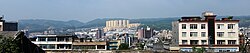
Zhaotong is a prefecture-level city located in the northeast corner of Yunnan province, China, bordering the provinces of Guizhou to the south and southeast and Sichuan to the northeast, north, and west.
Qujing is a prefecture-level city in the east of Yunnan province, China, bordering Guizhou province to the east and the Guangxi Zhuang Autonomous Region to the southeast; thus, it was called "Key between Yunnan and Guizhou" (滇黔锁钥) and "Throat of Yunnan" (云南咽喉) in the past. It is part of the Central Yunnan Metropolitan Region plan (滇中城市群规划) in effect for 2016–49. Its administrative population is 6,047,000 according to a 2015 estimate, of whom, 1,408,500 reside in the metro area, which contains Qilin District, Zhanyi District and Malong District. During the 11th National Five-Year Plan period, the government of Qujing planned to develop the city into the "big city at the origin of the Pearl River" (珠江源大城市) in the following decades, including increasing the built-up urban area to past 100 km2 (39 sq mi) and the urban population to surpass 1 million by 2020, the second in Yunnan, after Kunming.
Duyun is the capital of Qiannan Buyei and Miao Autonomous Prefecture in Guizhou province, China.
Bijie is a prefecture-level city in northwestern Guizhou Province, China, bordering Sichuan to the north and Yunnan to the west.
Jiangcheng Hani and Yi Autonomous County is an autonomous county under the jurisdiction of Pu'er City, in southern Yunnan, China, bordering Laos and Vietnam to the south, making it the only county in the province to border more than one country. By road, its seat, the town of Menglie (勐烈镇), is 520 km (320 mi) from Kunming and 145 km (90 mi) from Simao District, the municipal seat of Pu'er.
Jingdong Yi Autonomous County is an autonomous county in the west-central part of Yunnan Province, China. It is the northernmost county-level division of the prefecture-level city of Pu'er.
Jinggu Dai and Yi Autonomous County is an autonomous county under the jurisdiction of Pu'er City, Yunnan Province, China.
Zhaoyang District is the only district and the seat of the city of Zhaotong, in the northeast of Yunnan Province, China. It borders the provinces of Guizhou to the southeast and Sichuan to the west.
The transport infrastructure of Yunnan is served by numerous transport modes, and forms an integral part of the structure Yunnan Province and the Southwest of China. Yunnan is served by several civilian airports and a major highway and rail network. The province is served by a network of bus routes that radiates from the capital city, Kunming.
Yuanshi County is located in the southwest of Hebei Province, North China, 40 kilometres (25 mi) to the south of Shijiazhuang, the provincial capital. Yuanshi County borders Gaoyi County to the south, Zhao County and Luancheng District to the east, Jingxing County to the west and Luquan District to its north.
Guantao County is a county of southern Hebei province, China, bordering Shandong's Guan County and Linqing to the east across the Wei Canal (卫运河). It is under the administration of Handan City, and has a population of 320,000 residing in an area of 456 km2 (176 sq mi). Jinan lies 160 kilometres (99 mi) to the east, Handan 75 km (47 mi) to the west, and Beijing 420 km (260 mi) to the north, and the county is served by G22 Qingdao–Lanzhou Expressway and China National Highways 106 and 309. The area was formerly part of Shandong Province.
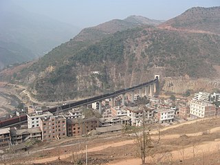
The Neijiang–Kunming railway or Neikun railway, is a single-track railroad between Neijiang and Kunming in Southwest China. The line runs 872 km (542 mi) from Neijiang in Sichuan province to Kunming in Yunnan province through western Guizhou province. The Neikun Line was built in three sections. The northern section, from Neijiang to Anbian township of Yibin and 140 km (87 mi) in length, was built from 1956 to 1960. The southern section from Kunming to Meihuashan station, near Liupanshui in Guizhou, and 370 km (230 mi) in length, was built from 1960 to 1965 and became the westernmost segment of the Guiyang-Kunming railway. The middle section between Anbian and Meihuashan through Zhaotong and 358 km (222 mi) in length was built from 1998 to 2001. Major cities and towns along route include Neijiang, Zigong, Yibin, Shuifu, Zhaotong, Weining County, Xuanwei, Qujing and Kunming.
Chengdu-Guiyang high-speed railway is a major trunk high-speed railway between the provincial capitals of Chengdu, Sichuan and Guiyang, Guizhou via a small section traversing north east Yunnan province. It was selected for construction under the 11th Five Year Plan set by the Chinese Government. Construction started in 2010 and was expected to be completed by 2014. The northern section of this line between Chengdu and Leshan forms the southern part of the operational Chengdu–Mianyang–Leshan intercity railway.