China has great physical diversity. The eastern plain and southern coasts of the country consist of fertile lowlands and foothills. They are the location of most of China's agricultural output and human population. The southern areas of the country consist of hilly and mountainous terrain. The west and north of the country are dominated by sunken basins, rolling plateaus, and towering massifs. It contains part of the highest tableland on earth, the Tibetan Plateau, and has much lower agricultural potential and population.
Guizhou is an inland province in Southwestern China. Its capital and largest city is Guiyang, in the center of the province. Guizhou borders the autonomous region of Guangxi to the south, Yunnan to the west, Sichuan to the northwest, the municipality of Chongqing to the north, and Hunan to the east. The Guizhou Province has a Humid subtropical climate. It covers a total area of 176,200 square kilometers and consists of six prefecture-level cities and three autonomous prefectures. The population of Guizhou stands at 38.5 million, ranking 18th among the provinces in China.

Guiyang is the capital of Guizhou province of the People's Republic of China. It is located in the center of the province, situated on the east of the Yunnan–Guizhou Plateau, and on the north bank of the Nanming River, a branch of the Wu River. The city has an elevation of about 1,100 meters (3,600 ft). It has an area of 8,034 square kilometers (3,102 sq mi). At the 2020 census, its population was 5,987,018, out of whom 4,506,134 lived in the six urban districts.

Yibin is a prefecture-level city in the southeastern part of Sichuan province, China, located at the junction of the Min and Yangtze Rivers. Its population was 4,588,804 inhabitants, according to the 2020 census, of whom 2,158,312 lived in the built-up area comprising three urban districts.

The Daxue Range or Daxue Mountains (Chinese: 大雪山山脉, 大雪山; pinyin: Dàxuě Shān; Wade–Giles: Ta4-hsüeh3 Shan1; lit. 'Great Snow Mountains') are a great mountain range in the western part of Sichuan province in Southwest China. It is part of the Hengduan Mountains, a complicated system of mountain ranges of western Sichuan, which itself is adjacent to the eastern edge of the Tibetan Plateau.

The Sichuan Basin, formerly transliterated as the Szechwan Basin, sometimes called the Red Basin, is a lowland region in southwestern China. It is surrounded by mountains on all sides and is drained by the upper Yangtze River and its tributaries. The basin is anchored by Chengdu, the capital of Sichuan province, in the west, and the direct-administered municipality of Chongqing in the east. Due to its relative flatness and fertile soils, it is able to support a population of more than 100 million. In addition to being a dominant geographical feature of the region, the Sichuan Basin also constitutes a cultural sphere that is distinguished by its own unique customs, cuisine and dialects. It is famous for its rice cultivation and is often considered the breadbasket of China. In the 21st century its industrial base is expanding with growth in the high-tech, aerospace, and petroleum industries.
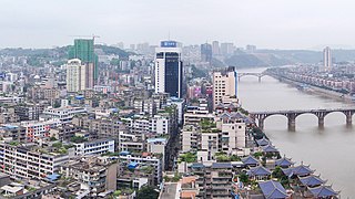
Luzhou (simplified Chinese: 泸州; traditional Chinese: 瀘州; pinyin: Lúzhōu; Sichuanese Pinyin: Nu2zou1; Luzhou dialect: ), formerly transliterated as Lu-chou or Luchow, is a prefecture-level city located in the southeast of Sichuan Province, China. It is also known as the "Liquor City" (酒城). It was named Jiangyang (simplified Chinese: 江阳; traditional Chinese: 江陽; pinyin: Jiāngyáng) until the Northern and Southern dynasties. Situated at the confluence of the Tuo River and the Yangtze River, Luzhou has been Sichuan province's largest port in both size and output since Chongqing's separation from Sichuan in 1997. As of the 2020 Chinese census, its population was 4,254,149. Of these, 1,241,273 lived in the built-up (or metro) area made of Jiangyang and Longmatan districts, as Naxi district is not conurbated yet. Luzhou borders Yunnan, Guizhou and Chongqing provinces. As the only geographic junction of the four provinces, it was an important port location in ancient China. After the PRC was founded in 1949, Luzhou became the capital of southern Sichuan province. In 1983, Luzhou was upgraded to prefecture-level city status.
The Yun Range are a mountain range running north–south in northwestern Yunnan province, China. They were formerly romanized as the Yun Ling and tautologically as the Yun-ling Mountains. The Yun Range runs between the Lancang River (Mekong) to the west and Jinsha River (Yangtze) to the east. The range is a major component of the greater Hengduan Mountains.

Southwestern China is a region in the People's Republic of China. It consists of five provincial administrative regions, namely Chongqing, Sichuan, Guizhou, Yunnan, and Xizang.

The Hengduan Mountains are a group of mountain ranges in southwest China that connect the southeast portions of the Tibetan Plateau with the Yunnan–Guizhou Plateau. The Hengduan Mountains are primarily large north-south mountain ranges that effectively separate lowlands in northern Myanmar from the lowlands of the Sichuan Basin. These ranges are characterized by significant vertical relief originating from the Indian subcontinent's collision with the Eurasian Plate, and further carved out by the major rivers draining the eastern Tibetan Plateau. These rivers, the Yangtze, Mekong, and Salween, are recognized today as the Three Parallel Rivers UNESCO World Heritage Site.
The Mountains of Southwest China is a biodiversity hotspot designated by Conservation International which includes several temperate coniferous forests in southwestern China, which lie in the river valleys on the southeastern corner of the Tibetan plateau, between the alpine scrublands and steppes of the Tibetan Plateau and the temperate broadleaf and mixed and subtropical moist broadleaf forests of central and southeastern China and northern Myanmar. The hotspot is mostly in China, in the provinces of Tibet, Sichuan, Qinghai, and Gansu, and extending into the northwestern Myanmar.

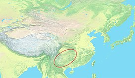
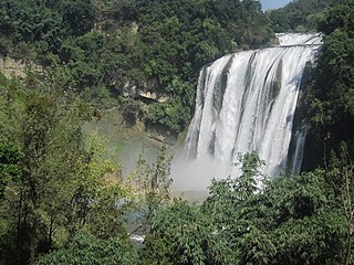
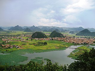
The South China Karst, a UNESCO World Heritage Site since June 2007, spans the provinces of Chongqing, Guangxi, Guizhou, and Yunnan. It is noted for its karst features and landscapes as well as rich biodiversity. The site comprises seven clusters Phase I: Libo Karst, Shilin Karst, and Wulong Karst inscribed in 2007, and Phase II: Guilin Karst, Shibing Karst, Jinfoshan Karst, and Huanjiang Karst inscribed in 2014. UNESCO describes the South China Karst as "unrivalled in terms of the diversity of its karst features and landscapes".

The Hengduan Mountains subalpine conifer forests are a temperate forest in the Hengduan Mountains of southwestern China. The forests extend within the Jinsha and Yalong River valleys from approximately 32°N to 27°N. In addition, a portion of the Anning River valley and Mianmian Mountains near Lugu Lake support the subalpine conifer forests. This region covers northern Yunnan Province, western Sichuan Province, and the extreme eastern edge of the Tibet Autonomous Region.

The Xiluodu Dam is an arch dam on the Jinsha River, i.e. the upper course of the Yangtze in China. It is located near the town of Xiluodu in Yongshan County of Yunnan Province but the dam straddles into Leibo County of Sichuan Province on the opposite side of the river. The primary purpose of the dam is hydroelectric power generation and its power station has an installed capacity of 13,860 MW. Additionally, the dam provides for flood control, silt control and its regulated water releases are intended to improve navigation downstream. Construction on the dam and power station began in 2005 and the first generator was commissioned in 2013, the last in 2014. It is operated by China Yangtze Power and is currently the fourth-largest power station in the world, as well as the fifth tallest dam world-wide.
Physiographic macroregions of China is a term suggested by an American anthropologist G. William Skinner as a subdivision of China Proper into nine areas according to the drainage basins of the major rivers and other travel-constraining geomorphological features. They are distinct in terms of environment, economic resources, culture and more or less interdependent histories with often unsynchronized developmental macrocycles. They were described in Skinner's landmark essays in The City in Late Imperial China.

The Xiaoxiang Range is a mountain range in Sichuan Province, China. It is part of a complicated system of mountains in south-central Sichuan, and runs in the general north-south direction within Liangshan Yi Autonomous Prefecture and the adjacent parts of Ya'an prefecture-level city.
The Yunnan Plateau subtropical evergreen forests is an endangered ecoregion in southwestern China. These forests once covered the western parts of the Yungui Plateau but have been significantly reduced and replaced with agricultural land uses. The Yunnan evergreen forests and the neighbouring Guizhou Plateau broadleaf and mixed forests are the only two ecoregions in the Palearctic realm to be classified as part of tropical and subtropical moist broadleaf forests biome.

The Guizhou Plateau broadleaf and mixed forests are a subtropical moist broadleaf forest ecoregion in the Yungui Plateau of China. Much of the original forest has been replaced by secondary forests.

The Jiang Nan subtropical evergreen forests ecoregion covers the mountainous divide between the lower Yangtze River and the coastal plain of South China. The region is also a climatic divide between the temperate valleys of the north and the subtropical forests of the south. The region is important for biodiversity and endemic species. The rugged limestone karst hills have been relatively protected from conversion to agriculture, and support specialized plant and animal communities.