Xishuangbanna Dai Autonomous Prefecture

Last updated
Xishuangbanna Prefecture
西双版纳州 · Xishuangbanna.svg
Sibsongpanna · Sipsong Panna
Xishuangbanna Dai Autonomous Prefecture
西双版纳傣族自治州
Xishuangbanna Dai Autonomous Prefecture.svg
Jinghongcity.jpg
Jinghong City
Yunnan subdivisions - Xishuangbanna.svg
Location of Xishuangbanna Dai Autonomous Prefecture in Yunnan
Coordinates: 22°00′N100°48′E / 22.000°N 100.800°E / 22.000; 100.800
Country China
Province Yunnan Province
GB/T 2260 CODE [1] 532800
Admin HQ Jinghong
Admin units
Government
  Type Autonomous prefecture
   CCP Secretary Zheng Yi
   Congress ChairmanXu Jiafu
   Governor Dao Wen
   CPPCC ChairmanZhang Xing
Area
  Total19,700 km2 (7,600 sq mi)
Population
 (2010)
  Total1,133,515
  Density58/km2 (150/sq mi)
GDP [2]
  Total CN¥ 72.1 billion
US$ 10.6 billion
  Per capitaCN¥ 55,194
US$8,141
Time zone UTC+08:00 (Chinese Standard Time)
Postal code
666100 [3]
Area code +959 [3]
ISO 3166 code CN-YN-28
Website www.xsbn.gov.cn
"Yunnan Statistics Bureau".
"Yunnan Portal".
᧑᧒ᦗᧃᦓᦱ
[síp.sɔ́ŋ.pân.nâː]

Before 1886, the region was called Chiang Hung, a Tai Lue Kingdom contended between China, Lanna and the Burmese dynasties. Following the Mongol conquest in 1296, subsequent Ming and Qing emperors appointed the Tai Lue rulers of Chiang Hung as a native Tusi governor. [8] In 1563, King Bayinnaung of Burma's Taungoo Dynasty captured Chiang Hung. The Burmese and the Chinese agreed on the joint domination over Xishuangbanna, whose ruler was enthroned in a ceremony in which both Burmese and Chinese representatives jointly presided. [9] After internal disputes regardign In the 19th century, it briefly became a tributary state of Luang Prabang and the Rattanakosin Kingdom during the Burmese–Siamese War (1849–1855). [10] When the British Empire occupied Upper Burma in 1886, it became a part of British India. In 1892, the British transferred Chiang Hung to the Qing Dynasty.

In the chaos of the Xinhai Revolution that overthrew the Qing government in 1911 in favor of a Chinese republican government, a local leader, the Chao Maha of Meng Jie, staged a rebellion against Qing remnant officials. The Yunnan provincial government of the newly established Republic of China sent troops in 1913 to oust the Chao Meng Jie rebels. [11] Ke Shuxun remained in Xishuangbanna to govern with his "13 Principles of Governing the Frontier", which emphasized equality between Han and Dai in areas such as land ownership and taxation, allowed intermarriage between the ethnic groups and promoted education in secular and technical subjects, rather than Burmese-based monastic education. [12] The Second Sino-Japanese War (1931-1945) saw the heavy bombardment of Xishuangbanna by Japanese troops and a simultaneous influx of Pan-Taiist propaganda from Japan's ally, Thailand. According to Hsieh, [13] this reduced the appeal of a broad pan-Tai identity among the Dai Lue.

During the final phase of the Chinese Civil War, many remnants of the Kuomintang fled from Communists forces into Burma's Shan State from Xishuangbanna. The new People's Republic of China sent various non-military expeditions to Xishuangbanna from 1949 to provide services such as schools and hospitals to replace those from Christian western missionaries. [14]

The Communists took control of the prefecture from Kuomintang loyalists in 1952. On January 23, 1953, the PRC established the Xishuangbanna Dai Autonomous Region and ended the native-chieftain system. That year, the People's Congress of Xishuangbanna created the New Tai Lue alphabet, based on the Tai Tham alphabet, for printing material in the Tai Lü language. [15]

Xishuangbanna was made an autonomous prefecture in 1955 but lost some territory on the creation of Jingdong Yi Autonomous County and Jiangcheng Hani and Yi Autonomous County. [16] Land reform started in earnest in January 1956, destroying the power of the village headmen. [17] State-owned rubber plantations accounted for most of the region's wealth during the early PRC period.

Xishuangbanna also received an influx of educated youth during the Down to the Countryside Movement of the Cultural Revolution (1966-1976). During this period Buddhist temples in Xishuangbanna were used as barns, only being restored to their original purpose in 1981. [18]

In 1987, the Xishuangbanna government promulgated the Law of the Xishuangbanna Dai Nationality Autonomous Prefecture for Self-government to bring local laws into line with the national Law of the People's Republic of China for Regional National Autonomy. [19]

Shao Cunxin (召存信, 1922–2015), former head of the Chieftain's outer council (1944–1950) and chief of Meng Peng (1938–1950), was the chief of the autonomous prefecture from 1955 to 1992.

Administrative subdivisions

Xishuangbanna Dai Autonomous Prefecture
Chinese name
Simplified Chinese 西双版纳 傣族 自治州
Traditional Chinese 西雙版納 傣族 自治州
Historical population
YearPop.±%
2000C 993,397    
2010C 1,133,515+14.1%
sources: [20]

Xishuangbanna governs one county-level city and two counties.

Map
Name Chinese characters Pinyin Population
(2000C)
Population
(2010C)
Urban Pop
(2000C)
Urban Pop
(2010C)
Area (km2)Density
(/km2)
Jinghong City 景洪市Jǐnghóng Shì443,600519,935138,939205,5237,13373
Menghai County 勐海县Měnghǎi Xiàn314,100331,85034,24194,9455,51160
Mengla County 勐腊县Měnglà Xiàn235,700281,73055,63284,6257,05640

Geography

The prefecture has an area of 19,700 km2 (7,600 sq mi). Xishuangbanna is the home of the Dai people. The region sits at a lower altitude than most of Yunnan, and has a humid subtropical climate (Köppen climate classification Cfa) that borders closely on a tropical savanna climate (Köppen climate classification Aw).

Climate data for Jinghong
MonthJanFebMarAprMayJunJulAugSepOctNovDecYear
Record high °C (°F)31.5
(88.7)
34.3
(93.7)
37.5
(99.5)
41.1
(106.0)
40.1
(104.2)
37.7
(99.9)
35.7
(96.3)
35.8
(96.4)
35.4
(95.7)
34.1
(93.4)
31.8
(89.2)
30.2
(86.4)
41.1
(106.0)
Mean daily maximum °C (°F)26.3
(79.3)
29.5
(85.1)
31.9
(89.4)
33.4
(92.1)
33.0
(91.4)
32.2
(90.0)
31.1
(88.0)
31.4
(88.5)
31.4
(88.5)
29.7
(85.5)
27.5
(81.5)
25.0
(77.0)
30.2
(86.4)
Daily mean °C (°F)17.5
(63.5)
19.6
(67.3)
22.1
(71.8)
24.7
(76.5)
26.0
(78.8)
26.6
(79.9)
26.0
(78.8)
25.9
(78.6)
25.3
(77.5)
23.5
(74.3)
20.3
(68.5)
17.5
(63.5)
22.9
(73.3)
Mean daily minimum °C (°F)12.3
(54.1)
12.7
(54.9)
15.2
(59.4)
18.6
(65.5)
21.4
(70.5)
23.2
(73.8)
23.1
(73.6)
22.9
(73.2)
22.1
(71.8)
20.3
(68.5)
16.6
(61.9)
13.6
(56.5)
18.5
(65.3)
Record low °C (°F)2.7
(36.9)
6.6
(43.9)
6.2
(43.2)
11.9
(53.4)
16.2
(61.2)
18.1
(64.6)
18.9
(66.0)
19.3
(66.7)
16.2
(61.2)
12.0
(53.6)
7.2
(45.0)
1.9
(35.4)
1.9
(35.4)
Average precipitation mm (inches)20.3
(0.80)
9.5
(0.37)
28.4
(1.12)
56.3
(2.22)
130.6
(5.14)
138.0
(5.43)
232.4
(9.15)
217.4
(8.56)
138.9
(5.47)
104.4
(4.11)
41.1
(1.62)
22.9
(0.90)
1,140.2
(44.89)
Average precipitation days (≥ 0.1 mm)2.92.64.69.716.219.122.721.415.411.85.53.7135.6
Average relative humidity (%)77666568747983838384838277
Mean monthly sunshine hours 212.5230.5229.9228.3206.0155.5125.0149.7173.3166.9181.5175.92,235
Percent possible sunshine 63716260503930384747555351
Source 1: China Meteorological Administration (precipitation days, humidity, sunshine 1991–2020) [23] [24]
Source 2: Weather China [25]

Biodiversity

Passiflora xishuangbannaensis Passiflora xishuangbannaensis1.jpg
Passiflora xishuangbannaensis

Xishuangbanna harbors much of the biodiversity of Yunnan, which harbors much of the biodiversity of China. Its tropical climate and its remoteness until recent times account for this. In addition to an abundance of plants, Xishuangbanna is home to the last few Asian elephants still in China; the species roamed over a large part of the country even as late as a few hundred years ago. The elephants are protected in a reserve, but the plant diversity is threatened by, and has for five decades been threatened by, the proliferation of natural rubber plantations which completely destroy the rainforest and replace it with a monoculture of trees originally from Brazil. [26]

Passiflora xishuangbannaensis is a recently discovered passiflora species that is endemic to Xishuangbanna.

Demographics

The 2000 national census documented that Xishuangbanna had 993,397 inhabitants with a population density of 50.43 inhabitants per km2. According to the 2000 national census, Dai people make up the plurality at 29.89%, with the Han Chinese coming in at a close second at 29.11%. At the time of the 1977 census, however, Han people made up the largest single ethnic group in Xishuangbanna, making up 36.53% of a population of 627,089, while Dai made up 33.15%, and others 30.32%. The Xishuangbanna government has strived to maintain this ethnic balance of around 33% of each group: Han, Dai, and other; this policy is known as "the plan of three-three-three" (三三三计划; sān-sān-sān jìhuà) [27]

Before the increasing social mobility of the 1940s, inhabitants of Xishuangbanna called each other "basin people" (壩區民族; bàqū mínzú) or "mountain people" (山區民族; shānqū mínzú) in reference to the groups' stereotyped location. The Han and Dai lived mostly around the mountains and played a socially dominant role, while the non-Dai ethnic minorities lived in the basins and were politically disenfranchised. [28] The Dai used to be called the Baiyi (摆夷), and until a 1936 Kuomintang reform, the bai part was written with the dog radical ( ). The PRC government decided that regardless of radical, the term Baiyi is pejorative, and adopted Dai () instead. [29] Historically, some ethnic minorities adapted some Dai characteristics in order to alleviate discrimination and increase their social status, such as the Blang people adopting the sarong, practicing matrilocal residence, and learning the Tai Tham alphabet. [30]

Ethnic groups

The Blang village of Manpo. ManpoVillage.jpg
The Blang village of Manpo.
Ethnic groups in Xishuangbanna, 2000 census
Ethnicity PopulationPercentage
Dai (Tai Lü, Tai Ya, Tai Nüa, Tai Yuan, Lao)296,93029.89%
Han Chinese 289,18129.11%
Hani 186,06718.73%
Yi 55,7725.61%
Lahu 55,5485.59%
Blang 36,4533.67%
Jino 20,1992.03%
Yao 18,6791.88%
Miao 11,0371.11%
Bai 5,9310.6%
Jingpo5,6400.57%
Hui 3,9110.39%
Wa 3,1120.31%
Zhuang 2,1300.21%
Others2,8070.3%

In Jinghong City and Menghai County, the two major Hani subgroups are Jiuwei 鸠为 and Jizuo 吉坐. [31] The Jizuo 吉坐 are the largest Hani ethnic subgroup in Jinghong.

The Jiuwei claim to have migrated from Honghe and Mojiang. The Jiuwei live in various villages in Jinghong, including:

There are also ethnic Hani that are locally called Aini 爱尼 living in 7 villages on Nanlin Mountain 南林山 of southwestern Jinghong, namely Manbage 曼八阁, Manjinglong 曼景龙, Manjingnan 曼景囡, Mangudu 曼固独, Manbaqi 曼把奇, Manbasan 曼巴伞, and Manjingmai 曼景卖. [32]

Languages

Ethnic minority languages spoken in Sipsongpanna include:

Culture

Dai Ethnic Garden, 30 kilometers away from Jinghong city, is a popular ethnic theme park with natural Dai village and Buddhist temple Man Chunman Buddhist Temple, Dai Ethnic Garden, Xishuangbanna Prefecture, China.jpg
Dai Ethnic Garden, 30 kilometers away from Jinghong city, is a popular ethnic theme park with natural Dai village and Buddhist temple

The Six famous tea mountains region (Chinese:六大茶山; pinyin:Liù Dà Chá Shān) located in the prefecture produce some of the most highly regarded Pu-erh tea in the 20th century.

Xishuangbanna is rich in nature, historical and cultural resources, noted for its folklore, rain forests, rare plants, and wildlife. Its major tourist attractions include Menglun Tropical Botanical Garden, Manfeilong Pagodas (Tanuozhuanglong), Jingzhen Pavilion, Wild Elephant Gully, Dai people's village at Ganlanba. [ citation needed ] The Manchunman Buddhist Temple, which has a history of more than 1400 years, is also a very popular tourist attraction. The complex is made up of four parts, the main hall, the sutra collection pavilion, the gold pagoda, and the drum tower. The temple is well known within the Southeast Asian region and each year attracts Buddhist monks and visitors from Sri Lanka, Thailand, Myanmar and Laos. [33]

The well-known traditional festival is the Dai New Year, known as the Water-Splashing Festival. It lasts for three days from April 13 to 15. Besides the water festival event it also consists of some other events such as Dragon boat races, the firing of indigenous missiles, flying Kongming Lamps.[ citation needed ]

Transport

Since the opening of the Xishuangbanna Gasa Airport (formerly Jinghong International Airport) in 1990, traveling to Xishuangbanna by air has become more popular and convenient and there are daily flights connecting Xishuangbanna with Kunming City. The area also has air connections with Dali, Chengdu and Bangkok. The Xishuangbanna Airport is 6 km (3.7 mi) south of Jinghong City.

There are also bus routes to places all over Yunnan and neighboring provinces. It is 590 kilometers from Kunming to Jinghong. Long-distances buses depart from Kunming South Station and arrive at Jinghong Bus Station, costing CNY 210–250, which is about 8–10 hours duration. [34]

In October 2010, plans were announced for a 530 km (330 mi) railway linking Xishuangbanna to Vientiane, Laos; [35] the railway is now completed and in operation. [36] Connections to Thailand are also possible. [37]

See also

Related Research Articles

<span class="mw-page-title-main">Dai people</span> Ethnic group of Asia

The Dai people are several Tai-speaking ethnic groups living in the Xishuangbanna Dai Autonomous Prefecture and the Dehong Dai and Jingpo Autonomous Prefecture of China's Yunnan Province. The Dai people form one of the 56 ethnic groups officially recognized by the People's Republic of China. By extension, the term can apply to groups in Laos, Vietnam, Thailand and Myanmar when Dai is used to mean specifically Tai Yai, Lue, Chinese Shan, Tai Dam, Tai Khao or even Tai in general. For other names, please see the table below.

<span class="mw-page-title-main">Bulang people</span> Ethnic group of southwest China

The Bulangpeople are an ethnic group. They form one of the 56 ethnic groups officially recognized by the People's Republic of China.

<span class="mw-page-title-main">Jinghong</span> County-level city in Yunnan, China

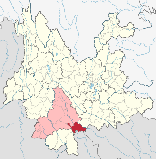
Jinghong is a city in and the seat of Xishuangbanna Dai Autonomous Prefecture, in the far south of China's Yunnan province, and the historic capital of the former Tai kingdom of Sipsongpanna.

Tai Lue or Xishuangbanna Dai is a Tai language of the Lu people, spoken by about 700,000 people in Southeast Asia. This includes 280,000 people in China (Yunnan), 200,000 in Burma, 134,000 in Laos, 83,000 in Thailand and 4,960 in Vietnam. The language is similar to other Tai languages and is closely related to Kham Mueang or Tai Yuan, which is also known as Northern Thai language. In Yunnan, it is spoken in all of Xishuangbanna Dai Autonomous Prefecture, as well as Jiangcheng Hani and Yi Autonomous County in Pu'er City.

<span class="mw-page-title-main">Dehong Dai and Jingpo Autonomous Prefecture</span> Autonomous prefecture in Yunnan, China

The Dehong Dai and Jingpo Autonomous Prefecture is an autonomous prefecture in western Yunnan province, China. It is bordered by Baoshan to the east and Myanmar's Kachin State to the west. Its titular ethnic minorities are the Dai and Jingpo, who make up 28 and 11 percent of the prefecture's population, respectively.

<span class="mw-page-title-main">Mangshi</span> County-level city in Yunnan, China

Mangshi, former name Luxi (潞西), is a county-level city and the seat of Dehong Dai and Jingpo Autonomous Prefecture, western Yunnan province, China. Mangshi has an area of 2,900.91 km2 (1,120.05 sq mi), with an urban area of 18.66 km2 (7.20 sq mi). Han Chinese, Dai people and Jingpo people are the major ethnic groups. Luxi County was founded in 1949, and became a county-level city in 1996.

Akha is the language spoken by the Akha people of southern China, eastern Burma, northern Laos, and northern Thailand.

<span class="mw-page-title-main">Bit language</span> Austroasiatic language spoken in Laos and China

Bit is an Austroasiatic language spoken by around 2,000 people in Phongsaly Province, northern Laos and in Mengla County, Yunnan, China.

<span class="mw-page-title-main">Jiangcheng Hani and Yi Autonomous County</span> Autonomous county in Yunnan, China

Jiangcheng Hani and Yi Autonomous County is an autonomous county under the jurisdiction of Pu'er City, in southern Yunnan, China, bordering Laos and Vietnam to the south, making it the only county in the province to border more than one country. By road, its seat, the town of Menglie (勐烈镇), is 520 km (320 mi) from Kunming and 145 km (90 mi) from Simao District, the municipal seat of Pu'er.

<span class="mw-page-title-main">Jinggu Dai and Yi Autonomous County</span> Autonomous county in Yunnan, China

Jinggu Dai and Yi Autonomous County is an autonomous county under the jurisdiction of Pu'er City, Yunnan Province, China.

<span class="mw-page-title-main">Menghai County</span> County in Yunnan, China

Menghai County is a county under the jurisdiction of Xishuangbanna Dai Autonomous Prefecture, in the far south of Yunnan, China, bordering Burma's Shan State to the southwest. Meng is as variation of Mueang.

<span class="mw-page-title-main">Mengla County</span> County in Yunnan, China

Mengla County is a county under the jurisdiction of the Xishuangbanna Dai Autonomous Prefecture, in far southern Yunnan province, China. Meng is a variation of Mueang.

<span class="mw-page-title-main">Chiang Hung</span> Shan state under Burma and China (1180–1950)

Chiang Hung, Sipsongpanna or Keng Hung was one of the states of Shans under the suzerainty of Burma and China.

Tai Ya, also known as Tai Cung, Tai Chung and Dai Ya, is a Southwestern Tai language of southern China. It has one dialect, Tai Hongjin ; Red Tai.

Hu, also Angku or Kon Keu, is a Palaungic language of Xishuangbanna Dai Autonomous Prefecture, Yunnan, China. Its speakers are an unclassified ethnic minority; the Chinese government counts the Angku as members of the Bulang nationality, but the Angku language is not intelligible with Bulang.

Sangkong is a Loloish language spoken in China by the Hani people in Xiaojie Township 小街乡, Jinghong County. They are called Buxia (布夏) by the local Dai people.

Akeu is a Loloish language mainly spoken in Jinghong and Mengla County, China, with smaller populations of speakers in Burma, Laos, and Thailand. Gokhy may be related.

Chao Mom Kham Lue, Chinese name Dao Shixun was the last native chief of Sipsongpanna, and a professor of linguistics. He was born Jinghong. He was the 28th Chao Phaen Din.

Gasa is a town located in the southwest part of Jinghong, Xishuangbanna Dai Autonomous Prefecture.

References

  1. 行政区划代码. 中华人民共和国国家统计局. Archived from the original on 2009-02-21. Retrieved 2009-01-29.
  2. 云南省统计局、国家统计局云南调查总队 (December 2023). 《云南统计年鉴-2023》. 中国统计出版社. ISBN   978-7-5037-9653-1.
  3. 1 2 "Area Code and Postal Code in Yunnan Province". China National Philatelic Corporation. Archived from the original on 2007-11-07.
  4. Hyde, Sandra Teresa (2007). "Sex tourism and the lure of the ethnic erotic in Southwest China". In Jensen, Lionel M.; Weston, Timothy B. (eds.). China's transformations: the stories beyond the headlines. Rowman & Littlefield. pp. 216–239. ISBN   9780742538634.
  5. Davis 2006, p. 106.
  6. Hansen 1999, p. 90.
  7. Gogoi, Shrutashwinee (2011). Tai ahom religion a philosophical study (PhD). p. 5. hdl:10603/116167.
  8. Giersch, Charles Patterson (2006). Asian Borderlands: The Transformation of Qing China's Yunnan Frontier. Harvard University Press.
  9. Andaya, Barbara Watson (19 Feb 2015). A History of Early Modern Southeast Asia, 1400-1830. Cambridge University Press.
  10. Thipakornwongse, Chao Phraya (1965). The Dynastic Chronicles Bangkok Era the Fourth Reign B.E. 2394-2411 (A.S. 1851–1868). Centre for East Asian Cultural Studies.
  11. Hsieh 1989, pp. 137–138.
  12. Hsieh 1989, pp. 156–158.
  13. Hsieh 1989, pp. 173–174.
  14. Hsieh 1989, pp. 193–194.
  15. Hsieh 1989, pp. 243–244.
  16. Hsieh 1989, p. 40.
  17. Hsieh 1989, pp. 188–189, 211.
  18. Hsieh 1989, p. 239.
  19. Hsieh 1989, p. 68.
  20. "CHINA: Administrative Population". Citypopulation.de. 2012-05-12. Retrieved 2013-10-31.
  21. Xishuangbanna Prefecture Bureau of Statistics (2011-05-25). 2010年西双版纳州第六次全国人口普查主要数据公报(第1号) [Communiqué on Major Data of the Sixth National Census of Xishuangbanna Prefecture in 2010 (No. 1)]. People's Government of Xishuangbanna Dai Autonomous Prefecture. Archived from the original on 2013-11-02. Retrieved 2013-10-31.
  22. "Yunnan (China): Province, Major Cities & Counties: Urban Population". Archived from the original on 2013-11-02. Retrieved 2013-10-31.
  23. 1981年-2010年(景洪)月平均气温和降水 (in Simplified Chinese). National Meteorological Center of CMA. Retrieved 29 November 2022.
  24. "中国气象数据网" (in Simplified Chinese). China Meteorological Administration . Retrieved 10 April 2023.
  25. 景洪 - 气象数据 -中国天气网 (in Simplified Chinese). Weather China. Retrieved 9 November 2022.
  26. "Corruption 'threatens China rainforest'". BBC News. 2008-08-21.
  27. Hsieh 1989, pp. 62–64.
  28. Hsieh 1989, pp. 44, 52.
  29. Hsieh 1989, p. 257.
  30. Hsieh 1989, p. 54.
  31. Yunnan Editors Committee 2009, pp. 116–119.
  32. Yunnan Editors Committee 2009, pp. 109–119.
  33. Yunnan Provincial Tourism Administration. "Manchunman Buddhist Temple". Yunnan Tourism Website. Archived from the original on 2018-04-29. Retrieved 2017-02-16.
  34. "Xishuangbanna Transport". ChinaTour.Net. Retrieved 2014-05-05.
  35. "New China-Laos link" . Railways Africa. 2010-10-22. Retrieved 2010-11-09.
  36. "Laos-China Railway Launches Crossborder Passenger Service". thediplomat.com. Retrieved 2023-05-10.
  37. "Standard gauge for Thailand" . Railways Africa. 2010-12-19. Retrieved 2010-12-19.

Literature