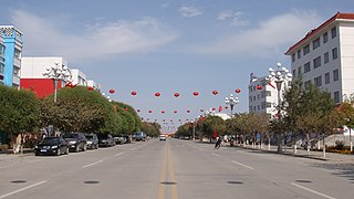
Yining County Gulja County | |
|---|---|
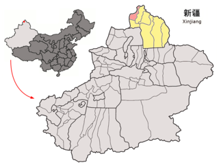
 Yining County (red) within Ili Prefecture (yellow) and Xinjiang | |
 Yining County Location in Xinjiang  Yining County Yining County (Xinjiang)  Yining County Yining County (China) | |
| Coordinates: 43°58′38″N81°31′39″E / 43.9771°N 81.5274°E | |
| Country | China |
| Autonomous region | Xinjiang |
| Autonomous prefecture | Ili |
| County seat | Jëlilyüzi |
| Area | |
• Total | 4,097 km2 (1,582 sq mi) |
| Population (2020) [1] | |
• Total | 365,307 |
| • Density | 89/km2 (230/sq mi) |
| Time zone | UTC+8 (China Standard [a] ) |
| Website | www |
- ↑ Locals in Xinjiang frequently observe UTC+6 (Xinjiang Time), 2 hours behind Beijing.
Related Research Articles

Yining, also known as Ghulja or Kulja, is a county-level city in northwestern Xinjiang, China. It is the administrative seat and largest city of Ili Kazakh Autonomous Prefecture. Historically, Yining is the successor to the ruined city of Almaliq in neighbouring Huocheng County. Yining is the third largest city in Xinjiang after Ürümqi and Korla.

Tacheng, also known as Tarbagatay, Chuguchak or Qoqek, is a county-level city and the administrative seat of Tacheng Prefecture, in northern Ili Kazakh Autonomous Prefecture, Xinjiang. The Chinese name "Tacheng" is an abbreviation of "Tarbagatay City", a reference to the Tarbagatay Mountains. Tacheng is located in the Dzungarian Basin, some 10 km (6.2 mi) from the Chinese border with Kazakhstan. For a long time it has been a major center for trade with Central Asia because it is an agricultural hub. Its industries include food processing, textiles, and utilities.

Qapqal Xibe Autonomous County in Ili Kazakh Autonomous Prefecture in Northern Xinjiang, is the only Xibe autonomous county of China, bordering Kazakhstan's Almaty Region to the west. It has an area of 4,430 square kilometers and a population 160,000 (2000). Qapqal means "the granary" in the Xibe language.
Fuhai County as the official romanized name, also transliterated from Uyghur as Burultokay County, is a county in the Xinjiang Uyghur Autonomous Region and is under the administration of the Altay Prefecture. It has an area of 33,319.38 km2 (12,864.68 sq mi) with a population of 65,600. The county's postcode is 836400.
Habahe County as the official romanized name, also transliterated from Uyghur as Kaba County, is a county situated in the far north of the Xinjiang Uyghur Autonomous Region and is under the administration of the Altay Prefecture. It has an area of 8,179 km2 (3,158 sq mi) with a population of 80,000. The Postcode is 836700.

Qinggil County (Uyghur), also Chinggil County, Qinghe County, is a county of Altay Prefecture in northeastern Xinjiang, China, bordering Bayan-Ölgii Province and Khovd Province in Mongolia to the east. It has an area of 15,722 km2 (6,070 sq mi) with a population of 60,000. Qinghe was the site of a meteorite impact in 1898 and a Mongolian–Chinese border clash in the spring of 1944.

Jeminay County or Jimunai County, is a county situated in the north of the Xinjiang Uyghur Autonomous Region and is under the administration of the Altay Prefecture.

Yumin County as the official romanized name, also transliterated from Mongolian as Qagantokay County, is a county situated in the Xinjiang Uyghur Autonomous Region and is under the administration of the Tacheng Prefecture, bordering Kazakhstan's regions of East Kazakhstan and Almaty. It has an area of 6,090 km2 (2,350 sq mi) with a population of 50,000. The Postcode is 834800.

Shawan, also transliterated from Chinese to Uyghur as Savan, is a county-level city situated in the north of the Xinjiang Uyghur Autonomous Region under the administration of the Tacheng Prefecture. It has an area of 12,468 km2 (4,814 sq mi) with a population of 200,000.

Toli County is a county situated in the north of the Xinjiang Uyghur Autonomous Region and is under the administration of the Tacheng Prefecture. It has an area of 19,982 km2 (7,715 sq mi) with a population of 90,000. The Postcode is 834500.

Emin County, the official romanized name, also transliterated from Mongolian as Dörbiljin County, is a county situated in the north of the Xinjiang Uyghur Autonomous Region and is under the administration of the Tacheng Prefecture, bordering Kazakhstan's districts of Tarbagatay and Zaysan. It has an area of 9,092 km2 (3,510 sq mi) with a population of 200,000. The Postcode is 834600.
Yuli County as the official Romanized name, also transliterated from Mongolian as Lopnur County, is a county in the Xinjiang Uyghur Autonomous Region and is under the administration of the Bayin'gholin Mongol Autonomous Prefecture. It contains an area of 59,399 km2 (22,934 sq mi). According to the 2002 census, it has a population of 100,000.

Jinghe County as the official romanized name, also transliterated from Uyghur as Jing County, is a county of the Xinjiang Uyghur Autonomous Region and is under the administration of the Börtala Mongol Autonomous Prefecture. It contains an area of 11,181 square kilometres (4,317 sq mi). According to the 2002 census, it has a population of 120,000.

Koktokay county, also known as Fuyun County, is a county of Altay Prefecture, in the Xinjiang Uyghur Autonomous Region of China. It has an area of 32,237 km2 with a population of 80,000. The seat of Fuyun County is in Ku Ertix Town. The Koktokay National Geopark is in Koktokay Town. The postal code of Fuyun County is 836100. The county is served by Fuyun Keketuohai Airport.
Nilka(pinyin: Nílèkè) County is a county situated in Xinjiang Uyghur Autonomous Region, China and is under the administration of the Ili Kazakh Autonomous Prefecture. It contains an area of 10,121 km2 (3,908 sq mi). According to the 2002 census, it has a population of 150,000.

Zhaosu County, also known as Mongolküre County, is a county in northwestern Xinjiang, China. It is under the administration of Ili Kazakh Autonomous Prefecture and shares a border with Kazakhstan's Almaty Region to the west. It covers an area of 10,455 km2 (4,037 sq mi). According to the 2012 census, it had a population of 189,102.

Xinyuan County as the official romanized name, also transliterated from Uyghur as Künas County, is a county in the Xinjiang Uyghur Autonomous Region and is under the administration of the Ili Kazakh Autonomous Prefecture. It contains an area of 7,581 km2. According to the 2002 census, it has a population of 290,000. The county is served by Xinyuan Nalati Airport.

Huocheng County, as the official romanized name, is also transliterated from Uyghur as Korgas County. It is situated within the Xinjiang Uyghur Autonomous Region and falls under the administration of the Ili Kazakh Autonomous Prefecture. The county is located between Yining and the border city of Khorgas, covering an area of 5,466 km2 (2,110 sq mi), with a population of 360,000. There are twenty-nine ethnic groups residing in the county, including the Han and Uyghur nationalities.

Gongliu County as the official romanized name, also transliterated from Uyghur as Tokkuztara County, is a county situated within the Xinjiang Uyghur Autonomous Region and is under the administration of the Ili Kazakh Autonomous Prefecture. It contains an area of 4,119 km2 (1,590 sq mi). According to the 2002 census, it has a population of 160,000.

Tekes County is a county within the Xinjiang Uyghur Autonomous Region and is under the administration of the Ili Kazakh Autonomous Prefecture. It contains an area of 8,067 km2. According to the 2002 census, it has a population of 150,000.
References
- ↑ Xinjiang: Prefectures, Cities, Districts and Counties
- ↑ Administrative division of Ili Kazakh Autonomous Prefecture (in Chinese)
- ↑ 2022年统计用区划代码和城乡划分代码:伊宁县. National Bureau of Statistics of China.
- ↑ 中国气象数据网 – WeatherBk Data (in Simplified Chinese). China Meteorological Administration . Retrieved 10 October 2023.
- ↑ 中国气象数据网 (in Simplified Chinese). China Meteorological Administration . Retrieved 10 October 2023.
- ↑ Haines, R Spencer (2016). "The Physical Remains of the Zunghar Legacy in Central Eurasia: Some Notes from the Field". Paper presented at the Social and Environmental Changes on the Mongolian Plateau Workshop, Canberra, ACT, Australia. The Australian National University.
- ↑ Yining County info, at the Ili Kazakh Autonomous Prefecture government site. (in Chinese)
- ↑ About the history of Yining City and Huocheng County (in Chinese)
External links
- County Government (in Chinese)
| Yining County | |||||||||||
|---|---|---|---|---|---|---|---|---|---|---|---|
| Chinese name | |||||||||||
| Simplified Chinese | 伊宁县 | ||||||||||
| Traditional Chinese | 伊寧縣 | ||||||||||
| |||||||||||
| |||||||||||
| | This Xinjiang location article is a stub. You can help Wikipedia by expanding it. |