Kalpin County Kelpin, Koping | |
---|---|
Coordinates: 40°26′36″N79°02′28″E / 40.44333°N 79.04111°E | |
Country | China |
Autonomous region | Xinjiang |
Prefecture | Aksu |
County seat | Kelpin Town |
Area | |
• Total | 8,912 km2 (3,441 sq mi) |
Population (2020) [2] | |
• Total | 50,619 |
• Density | 5.7/km2 (15/sq mi) |
Ethnic groups | |
• Major ethnic groups | Uyghur [1] |
Time zone | UTC+8 (China Standard [a] ) |
Website | www |
Kalpin County | |||||||||||
---|---|---|---|---|---|---|---|---|---|---|---|
Uyghur name | |||||||||||
Uyghur | كەلپىن ناھىيىسى | ||||||||||
| |||||||||||
Chinese name | |||||||||||
Simplified Chinese | 柯坪 县 | ||||||||||
Traditional Chinese | 柯坪 縣 | ||||||||||
|
Kalpin County [3] [4] [5] [6] [7] is a county in the Xinjiang Uygur Autonomous Region and is under the administration of the Aksu Prefecture. The overwhelmingly Uyghur population of the county lives on oases at the base of the Tian Shan (Tangri Tagh) mountains and on the edge of the Taklamakan Desert.
In 1902,a xiancheng ( 縣丞 ) was created at Kalpin. In 1930,a xianzhi ( 縣治 ) was created at Kalpin. [8]
According to Radio Free Asia ,in 2008,Chinese authorities demolished a Uyghur mosque 80 km (50 mi) from the Upper Kumtagh village in Kalpin County because the mosque was said to be illegally built and said to have been conducting illegal religious activities. [7]
On February 20,2009,a 5.2 magnitude earthquake struck at a location 35 km (22 mi) from the county seats of Kalpin and Akqi counties. 207 aftershocks had been recorded by 11 AM on February 22. More than ten thousand houses were damaged and 182 were destroyed. Forty tents[ clarification needed ] were set up and 12,400 people were relocated. The county received one million CNY in rescue funds from nearby government offices. [9]
On April 12,2014 at 11:40 PM,Abdulbasit Ablimit (Abdubasit Ablimit),17,of Qum'eriq[ where? ] village in Yurqi (Yurchi,Yu'erqi),was shot and killed by police while riding a motorcycle. Two other Uyghurs were injured. Four to five hundred people from their village participated in a protest at the county office demanding that the police officer be punished according to law. More than thirty of the protesters were detained and some were beaten. [10] [11] Tianshannet reported that on the following Wednesday,a man in Urumqi was detained by police for spreading rumors about the incident. [12] The Uyghur American Association condemned the killing. [13]
On April 3,2015,Aqal (ئاچالAqiale,Achal),then a township,was made a town. [14]
According to research presented in The Diplomat ,Xinjiang Nuodun Garment Co.,Ltd. (新疆诺顿服装有限公司),a company based in Kalpin County,was founded in July 2017. The company has made shipments of men and women's trousers to four companies in the United States. The company is also mentioned in the context of Aksu Prefecture's wider policy related to re-education camps in the Aksu Daily. [6]
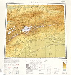
The county is made up of territory in the Tian Shan mountain range and the Taklamakan Desert. Kalpin,Gezlik and Yurqi are located west of Aqal. Qilan is located east of Aqal on the border with Aksu City. Mountain ranges in the county include Bozake Tagh,Kelpin Chöl Tagh,Chong Kizil Tagh,Kankerin Tagh,Chong Korum Tagh and Akin Bek Tagh. Rivers and streams in the county include Koram Boghuz,Chilan Su and Sargan.
Climate data for Kalpin,elevation 1,162 m (3,812 ft),(1991–2020 normals,extremes 1981–2010) | |||||||||||||
---|---|---|---|---|---|---|---|---|---|---|---|---|---|
Month | Jan | Feb | Mar | Apr | May | Jun | Jul | Aug | Sep | Oct | Nov | Dec | Year |
Record high °C (°F) | 9.2 (48.6) | 15.6 (60.1) | 27.8 (82.0) | 35.4 (95.7) | 36.2 (97.2) | 39.8 (103.6) | 41.9 (107.4) | 42.7 (108.9) | 37.2 (99.0) | 31.2 (88.2) | 23.9 (75.0) | 15.9 (60.6) | 42.7 (108.9) |
Mean daily maximum °C (°F) | −0.6 (30.9) | 5.9 (42.6) | 15.3 (59.5) | 23.6 (74.5) | 28.2 (82.8) | 31.7 (89.1) | 33.4 (92.1) | 32.3 (90.1) | 27.8 (82.0) | 20.7 (69.3) | 10.7 (51.3) | 1.5 (34.7) | 19.2 (66.6) |
Daily mean °C (°F) | −7.5 (18.5) | −0.9 (30.4) | 8.3 (46.9) | 16.3 (61.3) | 20.6 (69.1) | 23.8 (74.8) | 25.3 (77.5) | 24.2 (75.6) | 19.6 (67.3) | 11.9 (53.4) | 2.9 (37.2) | −5.0 (23.0) | 11.6 (52.9) |
Mean daily minimum °C (°F) | −13.3 (8.1) | −7.0 (19.4) | 1.5 (34.7) | 8.8 (47.8) | 13.3 (55.9) | 16.4 (61.5) | 18.2 (64.8) | 17.1 (62.8) | 12.3 (54.1) | 4.5 (40.1) | −3.2 (26.2) | −9.9 (14.2) | 4.9 (40.8) |
Record low °C (°F) | −27.5 (−17.5) | −28.1 (−18.6) | −17.3 (0.9) | −3.6 (25.5) | 3.5 (38.3) | 8.5 (47.3) | 9.5 (49.1) | 9.4 (48.9) | 3.2 (37.8) | −3.9 (25.0) | −13.6 (7.5) | −25.0 (−13.0) | −28.1 (−18.6) |
Average precipitation mm (inches) | 2.0 (0.08) | 3.0 (0.12) | 4.0 (0.16) | 4.0 (0.16) | 13.8 (0.54) | 22.2 (0.87) | 26.6 (1.05) | 26.1 (1.03) | 15.0 (0.59) | 4.0 (0.16) | 0.9 (0.04) | 1.8 (0.07) | 123.4 (4.87) |
Average precipitation days (≥0.1 mm) | 2.5 | 2.1 | 1.0 | 1.5 | 4.7 | 7.8 | 9.2 | 7.9 | 4.7 | 1.3 | 0.9 | 2.1 | 45.7 |
Average snowy days | 4.7 | 3.0 | 0.6 | 0 | 0 | 0 | 0 | 0 | 0 | 0 | 1.0 | 4.4 | 13.7 |
Average relative humidity (%) | 66 | 55 | 40 | 33 | 37 | 42 | 46 | 49 | 51 | 51 | 57 | 69 | 50 |
Mean monthly sunshine hours | 185.7 | 181.5 | 194.6 | 207.8 | 248.5 | 267.8 | 274.6 | 257.2 | 238.1 | 242.9 | 197.7 | 172.6 | 2,669 |
Percent possible sunshine | 61 | 59 | 52 | 51 | 55 | 60 | 61 | 62 | 65 | 72 | 68 | 60 | 61 |
Source:China Meteorological Administration [15] [16] |
Kalpin County included three towns and two townships: [1] [17] [18]
Name | Simplified Chinese | Hanyu Pinyin | Uyghur (UEY) | Uyghur Latin (ULY) | Administrative division code | Notes | |
---|---|---|---|---|---|---|---|
Towns | |||||||
Kalpin Town | 柯坪镇 | Kēpíng Zhèn | كەلپىنبازىرى | kelpin baziri | 652929100 | ||
Gezlik Town | 盖孜力克镇 | GàizīlìkèZhèn | گەزلىكبازىرى | gezlik baziri | 652929101 | ||
Aqal Town | 阿恰勒镇 | ĀqiàlèZhèn | ئاچالبازىرى [19] | Achal baziri | 652929102 | formerly Achal Township (阿恰勒乡) | |
Townships | |||||||
Yurqi Township [20] | 玉尔其乡 | Yù'ěrqíXiāng | يۈرچىيېزىسى | yurchi yëzisi | 652929201 | ||
Qilan Township | 启浪乡 | Qǐlàng Xiāng | چىلانيېزىسى [21] | chilan yëzisi | 652929203 | ||
Kalpin County's economy is primarily agricultural,producing wheat,corn,sorghum,cotton,etc. Animal husbandry is also strong,including the raising of camels,sheep and other animals. Mineral resources include sulfur. Industries include mining,concrete and cotton processing among others. [22]
Spoons and other tableware made from the fragrant wood of apricot trees are a traditional product produced in the county. [5]
There is 126,000 mu of arable land in the county. [1] As of 1885 [update] ,there was about 4,270 acres (28,164 mu ) of cultivated land in Kalpin. [23]
Year | Pop. | ±% p.a. |
---|---|---|
2000 | 38,584 | — |
2010 | 44,261 | +1.38% |
[17] |
As of 2015, 53,804 of the 55,425 residents of the county were Uyghur, 1,501 were Han Chinese and 120 were from other ethnic groups. [24]
According to the 2002 census, it has a population of 40,000.[ citation needed ]
As of 1999, 97.31% of the population of Kalpin County was Uyghur and 2.54% of the population was Han Chinese. [25]
Historical English-language maps including Kalpin:
Uqturpan County or Uchturpan County, also Wushi County, is a county in the Xinjiang Uyghur Autonomous Region under the administration of Aksu Prefecture and shares an approximately 150 km (93 mi) long border with Kyrgyzstan's Issyk-Kul Region. The county is bordered to the northeast by Onsu County (Wensu), to the southeast by Aksu city, to the west by Akqi County in Kizilsu Kyrgyz Autonomous Prefecture and to the south by Kalpin County (Keping). It has an area of 9,012 square kilometres (3,480 sq mi) and as of the 2002 census a population of 180,000.
Awat County is a county in Aksu Prefecture, Xinjiang Uyghur Autonomous Region, China. Awat County is located on the southern foot of the Tian Shan mountain range and on the northern edge of the Taklamakan Desert.
Onsu County and from Mandarin Chinese Wensu County, is a county in the Xinjiang Uygur Autonomous Region and is under the administration of the Aksu Prefecture, bordering Kyrgyzstan's Issyk-Kul Region to the northwest. It contains an area of 14,309 km2 (5,525 sq mi).
Payzawat County, also via SASM/GNC romanization as Payziwat County, and via Mandarin Chinese as Jiashi County is a county in Kashgar Prefecture, Xinjiang Uyghur Autonomous Region, China, on the western rim of the Taklamakan Desert. To the east, the county borders Maralbexi County, to the south Yopurga County.
Kargilik County, also known as Yecheng County, is a county in southwest of the Xinjiang Uyghur Autonomous Region and is under the administration of the Kashgar Prefecture. It contains an area of 28,600 km2. To the north, the county borders Makit County. To the east, the county borders Guma County (Pishan) in Hotan Prefecture. To the west, the county borders Yarkant County, Poskam County and Taxkorgan Tajik Autonomous County. In the south, the county has a border of more than 80 km (50 mi) with Pakistan and India administered areas of Kashmir.
Yengisar County, also known as Yingjisha County, is a county of Kashgar Prefecture in southwest Xinjiang, China. It covers an area of 3,373 km2 (1,302 sq mi). As of the 2002 census, it had a population of 230,000.
Akto County is a county in Kizilsu Kyrgyz Autonomous Prefecture, Xinjiang Uygur Autonomous Region, China. The county borders Tajikistan and Kyrgyzstan and has two towns, 11 townships, four state-owned farms and a plant nursery under its jurisdiction. The county seat is Akto Town. The county has an area of 24,555 km2 (9,481 sq mi). In 2015 its population was 221,526; in 2017 it was 231,756.
Karakax County, alternatively Moyu County, also transliterated from Uyghur as Qaraqash County, alternately Qaraqash, is a county in the Xinjiang Uyghur Autonomous Region and is located in the southern edge of the Tarim Basin, it is under the administration of the Hotan Prefecture. It contains an area of 25,667 km2 (9,910 sq mi). According to the 2011 census it has a population of 577,000 and 98,1% are Uyghurs. The county is bordered to the north by Awat County in Aksu Prefecture, to the northeast by Lop County, to the southeast by Hotan County, to the northwest by Maralbexi County in Kashgar Prefecture, and to the southwest by Pishan County and Kunyu. Exclaves of Kunyu are located within the county.
Yutian County, also transliterated from Uyghur as Keriya County, is a county in Hotan Prefecture, Xinjiang Uyghur Autonomous Region, China. It is based at the Keriya Town, and is separate from Hotan County, which is another county in the same prefecture. The Yutian County has an area of 39,023 km2 (15,067 sq mi). According to the 2002 census, it has a population of 220,000. The county is bounded on the north by Aksu Prefecture, on the east by Minfeng/Niya County, on the west by Qira County and on the south by the Rutog and Gertse counties of the Tibet Autonomous Region.
Shule County, also known as Yengisheher County or Yengixahar County, is a county of Kashgar Prefecture, in Xinjiang, China. It is located to the south of Kashgar. In ancient times, the Shule area was once the home to a Xiyu oasis civilisation, the Shule Kingdom.
Pishan County as the official romanized name, also transliterated from Uyghur as Guma County, is a county within the Xinjiang Uyghur Autonomous Region and is under the administration of the Hotan Prefecture. It contains an area of 39,412 km2 (15,217 sq mi). According to the 2002 census, it has a population of 220,000. The county borders Maralbexi County and Makit County to the north, Karakax County, Hotan County and Kunyu to the east and Kargilik County to the west. The county includes lands near the Karakoram Pass which are part of the Aksai Chin area that is disputed between China and India.
Kizilto is a town of Akto County in Xinjiang Uygur Autonomous Region, China. Located in the southeastern part of the county, the town covers an area of 3,882 square kilometers with a population of 9,700. It has 12 administrative villages under its jurisdiction. Its seat is at Ordolung'ozu Village.
Qarlung, Charlung is a town of Akto County in Xinjiang Uygur Autonomous Region, China. Located in the southeast of the county, the town covers an area of 3,242 square kilometers with a population of 5,258. It has 5 administrative villages under its jurisdiction.
Koxtag is a town in Pishan/Guma County, Hotan Prefecture, Xinjiang, China.
Muji is a town in Pishan/Guma County, Hotan Prefecture, Xinjiang, China.
Pixna is a town in Pishan/Guma County, Hotan Prefecture, Xinjiang, China.
Hanerik is a town in Hotan County, Hotan Prefecture, Xinjiang, China.
Jiya is a township in the northeastern part of Hotan City in Hotan Prefecture, Xinjiang, China in an oasis area on the eastern bank of the White Jade River in the southwestern part of the Taklamakan Desert. To the north and east, Jiya borders Lop County, the county which Jiya was a part of until 2006, and to the south and west, Jiya borders the rest of Hotan city.
Qaka is a township in Qira County, Hotan Prefecture, Xinjiang, China.
Kalpin
2000年第五次人口普查,柯坪县常住总人口38584人,{...}2010年第六次人口普查,柯坪县常住总人口44261人,其中:柯坪镇8031人,盖孜力克乡12686人,玉尔其乡11085人,阿恰勒乡7309人,启浪乡5150人。 2013年1月23日,自治区政府(新政函[2013]17号)批复同意将柯坪县61.798平方千米区域划归阿拉尔市管辖。 2014年10月21日,自治区政府(新政函[2014]193号)批复同意撤销盖孜力克乡,设立盖孜力克镇。调整后,全县辖2个镇、3个乡:柯坪镇、盖孜力克镇、玉尔其乡、阿恰勒乡、启浪乡。 2015年4月3日,自治区政府(新政函[2015]85号)批复同意撤销阿恰勒乡,设立阿恰勒镇。调整后,全县辖3个镇、2个乡。
统计用区划代码 名称 652929100000 柯坪镇 652929101000 盖孜力克镇 652929102000 阿恰勒镇 652929201000 玉尔其乡 652929203000 启浪乡
玉尔其 yù ěr qí Yurqi 乡名。新疆柯坪县玉尔其乡,在县城北3公里。