Taxkorgan Tajik Autonomous County

Last updated
Taxkorgan Tajik Autonomous County
塔什库尔干塔吉克自治县 (Chinese)
تاشقۇرغان تاجیك ئاپتونوم ناھىيىسى (Uyghur)
توشقۈرغون تۇجىك ئوفتۇنۇم نويا (Sarikoli)
Tashkurgan Xinjiang.JPG
Location of Taxkorgan within Xinjiang (China).png
Taxkorgan County (red) in Kashgar Prefecture (yellow) and Xinjiang
China Xinjiang Southern location map.svg
Red pog.svg
Tashkurgan
Location of county seat in Xinjiang
China Xinjiang adm location map.svg
Red pog.svg
Tashkurgan
Tashkurgan (Xinjiang)
China edcp location map.svg
Red pog.svg
Tashkurgan
Tashkurgan (China)
Coordinates: 37°46′20″N75°13′48″E / 37.7721°N 75.2299°E / 37.7721; 75.2299
Country China
Autonomous region Xinjiang
Prefecture Kashgar
County seat Tashkurgan
Township-level divisions 12 [1]
Area
[1]
  Total25,000 km2 (10,000 sq mi)
Elevation
3,094 m (10,151 ft)
Population
 (2020) [2]
  Total39,946
  Density1.6/km2 (4.1/sq mi)
Ethnic groups
  Major ethnic groups Mountain Tajiks (China) [1] [3]
Time zone UTC+8 (China Standard [lower-alpha 1] )
Postal code
845250
Area code 998
Website www.tskeg.gov.cn (in Chinese)
تاشقۇرغان تاجىك ئاپتونوم ناھىيىسى

During the Han dynasty, the town of Tashkurgan was known as Puli (Chinese:蒲犁; pinyin:Púlí); [8] during the Tang dynasty, it was a protectorate of the Sassanids, during the Yuan dynasty it was part of the Chaghatai empire. It was part of China during the Qing dynasty.

Many centuries later, Tashkurgan became the capital of the Sarikol kingdom (色勒库尔), a kingdom of the Pamir Mountains, and later of Qiepantuo (朅盘陀) under the Persian Empire. At the northeast corner of the town is a huge fortress known as the Princess Castle dating from the Yuan dynasty (1279–1368 CE) and the subject of many colourful local legends. A ruined fire temple is near the fortress.

The region came under Chinese rule from Qing dynasty, to Republic of China and People's Republic of China.

On September 17, 1954, Taxkorgan was made an autonomous region (Chinese :自治区). In February 1955, it was made an autonomous county (Chinese :自治县). [9]

In 1955, Bulungkol was transferred to Akto County from Taxkorgan County. [10]

In August 2013, the Chinese Academy of Social Sciences announced that they excavated a cluster of Zoroastrian tombs in Taxkorgan. [11]

In May 2017, the county was hit with a magnitude 5.5 earthquake that killed eight and injured 29. [12]

Geography

Taxkorgan County is located in the eastern part of the Pamir Plateau, where the Kunlun, Karakoram, Hindukush and Tian Shan mountains come together, at the borders with Afghanistan (Wakhan Corridor), Tajikistan (Gorno-Badakhshan Province), Pakistan (Gilgit-Baltistan) and India (Ladakh). The county seat is Taxkorgan Town.

The territorial expanse of the county is 178 kilometres (111 mi) from north to south and 140 kilometres (87 mi) from east to west,[ citation needed ] the total area is about 25,000 square kilometres (9,700 sq mi), [1] with an average altitude above 4,000 metres (13,000 ft). [1] The county includes a significant part of the Trans-Karakoram Tract, disputed by India and Pakistan in the ongoing Kashmir conflict; while Pakistan and China settled the border issue in 1963, India continues to claim it as part of the state of Jammu and Kashmir.[ citation needed ]

The Muztagh Ata, at 7,546 metres (24,757 ft), and the Kongur Tagh, at 7,719 metres (25,325 ft), are the main peaks in the county, while the two main rivers are the Taxkorgan River and the Tiznap River.[ citation needed ] By including the Trans-Karakoram Tract, the county also borders several eight-thousanders, including K2, at 8,611 metres (28,251 ft) the second-highest mountain in the world.[ citation needed ] There are several hot springs and resources of gold, iron, and copper.[ citation needed ]

Climate

Taxkorgan has a cold desert climate (Köppen BWk), influenced by the high elevation, with long, very cold winters, and warm summers. Monthly daily average temperatures range from −11.9 °C (10.6 °F) in January to 16.4 °C (61.5 °F) in July, while the annual mean is 3.58 °C (38.4 °F). An average of only 68 millimetres (2.68 in) of precipitation falls per year

Taxkorgan Tajik Autonomous County
Welcome to Tashkurgan Tajik Autonomous County.jpg
A sign welcoming motorists to Tashkurgan (Taxkorgan) Tajik Autonomous County
Climate data for Taxkorgan (1971−2000)
MonthJanFebMarAprMayJunJulAugSepOctNovDecYear
Record high °C (°F)6.5
(43.7)
12.2
(54.0)
18.9
(66.0)
22.0
(71.6)
25.1
(77.2)
31.0
(87.8)
32.5
(90.5)
31.4
(88.5)
27.8
(82.0)
22.7
(72.9)
14.3
(57.7)
10.5
(50.9)
32.5
(90.5)
Average high °C (°F)−4.2
(24.4)
−1
(30)
6.0
(42.8)
12.8
(55.0)
16.7
(62.1)
20.5
(68.9)
23.7
(74.7)
23.3
(73.9)
18.6
(65.5)
11.6
(52.9)
4.8
(40.6)
−1.9
(28.6)
10.9
(51.6)
Daily mean °C (°F)−11.9
(10.6)
−8.2
(17.2)
−0.5
(31.1)
6.1
(43.0)
9.8
(49.6)
13.3
(55.9)
16.4
(61.5)
16.0
(60.8)
11.4
(52.5)
4.0
(39.2)
−3.4
(25.9)
−10.0
(14.0)
3.6
(38.5)
Average low °C (°F)−18.6
(−1.5)
−15.3
(4.5)
−7.3
(18.9)
−0.8
(30.6)
3.1
(37.6)
6.4
(43.5)
9.4
(48.9)
8.8
(47.8)
3.5
(38.3)
−3.8
(25.2)
−10.8
(12.6)
−16.6
(2.1)
−3.5
(25.7)
Record low °C (°F)−39.1
(−38.4)
−36.0
(−32.8)
−25.7
(−14.3)
−11.5
(11.3)
−5.6
(21.9)
−1.0
(30.2)
2.2
(36.0)
−0.2
(31.6)
−5.0
(23.0)
−12.2
(10.0)
−23.3
(−9.9)
−31.5
(−24.7)
−39.1
(−38.4)
Average precipitation mm (inches)3.2
(0.13)
2.6
(0.10)
2.4
(0.09)
4.8
(0.19)
8.0
(0.31)
15.5
(0.61)
11.3
(0.44)
9.6
(0.38)
6.0
(0.24)
2.1
(0.08)
.7
(0.03)
2.0
(0.08)
68.2
(2.68)
Average precipitation days (≥ 0.1 mm)2.12.42.22.55.16.86.24.62.91.7.51.638.6
Source: Weather.com.cn

Administrative divisions

The county administers 2 towns, 9 townships and 1 ethnic township, which then administer 50 village-level divisions. [1]

Name [10] :234–236 Sarikoli
(Uyghur Arabic)
Sarikoli
(in IPA)
Uyghur
(Erep Yeziⱪi)
Uyghur
(Siril Yezik)
Uyghur
(Yenɡi Yeziⱪ)
Chinese (Simplified) [1] [13] [14] Pinyin
Taxkorgan Town توشقۈرغون بۇزۇرtɔʃqyrʁɔnbuzurتاشقۇرغان بازىرىТашқурған базириTaxⱪurƣan baziri塔什库尔干镇Tǎshíkù’ěrgān Zhèn
Tajik Abat  [ zh; ug ]تۇجىكئوبود بۇزۇرtudʒikobod buzurتاجىك ئابات بازىرىТаҗик Абaт базириTajik Abat baziri塔吉克阿巴提镇Tǎjíkè Ābātí Zhèn
Taxkorgan Township  [ zh; ug ]توشقۈرغون دىيۇرtɔʃqyrʁɔndiyurتاشقۇرغان يېزىسىТашқурған йәзисиTaxⱪurƣan yezisi塔什库尔干乡Tǎshíkù’ěrgān Xiāng
Tagarma Township  [ zh; ug ]تاغارمى دىيۇرtaʁarmidiyurتاغارما يېزىسىТағарма йәзисиTaƣarma yezisi塔合曼乡Tǎhémàn Xiāng
Tiznap Township  [ zh; ug ]تىزنەف دىيۇرtiznefdiyurتىزناپ يېزىسىТизнап йәзисиTiznap yezisi提孜那甫乡Tízīnàfǔ Xiāng
Dafdar Township ذاۋذور دىيۇرðavðɔrdiyurدەفتەر يېزىسىДәфтәр йәзисиDefter yezisi达布达尔乡Dábùdá’ěr Xiāng
Weqa Township  [ zh; ug ]ۋاچا دىيۇرwatʃadiyurۋەچە يېزىسىВәчә йәзисиWeqe yezisi瓦恰乡Wǎqià Xiāng
Baldir Township  [ zh; ug ]بالدىر دىيۇرbaldirdiyurبەلدىر يېزىسىБалдир йәзисиBaldir yezisi班迪尔乡Bāndí’ěr Xiāng
Maryang Township  [ zh; ug ]ماريوڭ دىيۇرmarjɔŋdiyurمارياڭ يېزىسىМаряң йәзисиMaryang yezisi马尔洋乡Mǎ'ěryáng Xiāng
Datong Township  [ zh; ug ]تيڭ دىيۇرtyŋdiyurداتۇڭ يېزىسىДатуң йәзисиDatung yezisi大同乡Dàtóng Xiāng
Koguxluk Township  [ zh; ug ]قۇغۇشلۇغ دىيۇرquʁuʃluʁdiyurقوغۇشلۇق يېزىسىҚоғухлуқ йәзисиⱩoƣuxluⱪ yezisi库科西鲁格乡Kùkēxīlǔgé Xiāng
Kokyar Kyrgyz Township  [ zh; ug ]كوكيار قىرغىز دىيۇرkɔkjarqirʁizdiyurكۆكيار قىرغىز يېزىسىКөкяр Қирғиз йәзисиKɵkyar Ⱪirƣiz yezisi科克亚尔柯尔克孜族乡Kēkèyà’ěr Kē’ěrkèzīzú xiāng

Demographics

Historical population
YearPop.±% p.a.
199527,800    
200030,454+1.84%
201037,843+2.20%
[15]
Map including Taxkorgan (T'a-shih-k'u-erh-kan) (DMA, 1985) NJ-43-11 Taxkorgan, China; Soviet Union; Pakistan.jpg
Map including Taxkorgan (T'a-shih-k'u-erh-kan) (DMA, 1985)
Map including Taxkorgan (labeled as Tashkargan) (1917) STANFORD(1917) p61 PLATE19. SINKIANG (14597194848).jpg
Map including Taxkorgan (labeled as Tashkargan) (1917)
Map including areas in the southern part of today's Taxkorgan Tajik Autonomous County (AMS, 1955) Map India and Pakistan 1-250,000 Tile NJ 43-15 Shimshal.jpg
Map including areas in the southern part of today's Taxkorgan Tajik Autonomous County (AMS, 1955)
Map including areas in the southern part of today's Taxkorgan Tajik Autonomous County (ACIC, 1969) NJ-43-15 Shimshal, Pakistan.jpg
Map including areas in the southern part of today's Taxkorgan Tajik Autonomous County (ACIC, 1969)

As of 2018, Taxkorgan County had a population of 40,999, [16] up slightly from the 40,381 reported in 2015, [17] and the 37,843 counted in the 2010 Chinese Census. [15]

Ethnic composition

Taxkorgan Tajik Autonomous County Ethnic Composition
Ethnic group2015 [17] 2018 [16]
Mountain Tajiks 32,86781.39%33,71882.24%
Han Chinese 2,9117.21%2,6906.56%
Kyrgyz 2,3205.75%2,3695.78%
Uyghur 2,1795.40%2,1315.20%
Hui 300.07%290.07%
Kazakh 150.04%150.04%
Manchu 90.02%60.01%
Mongol 90.02%60.01%
Sibe 70.02%60.01%
Russian 1< 0.01%00.00%
Others330.08%290.07%
Total40,381100.00%40,999100.00%

Mountain Tajiks make up a supermajority of the county's population, with recent figures indicating they make up somewhere from 80.9% of the population, [1] to 82.24%. [16] Other prominent ethnic groups include the Han Chinese, the Kyrgyz, and Uyghurs. [16] [17]

In 1999, 6.28% of the population of Taxkorgan (Tashiku'ergan) County was Han Chinese and 5.08% of the population was Uyghur. [18]

In 1995, the total population of Taxkorgan was 27,800, among them 84% Tajiks of Xinjiang, who speak the Sarikoli language, 4% Han and 12% other nationalities.[ citation needed ]

Economy

Animal husbandry is the primary economic mode with agriculture. The well-known Dunbashi fat-tailed sheep (敦巴什大尾羊) are raised in the county as well as domestic yaks. Agricultural products include highland barley, wheat, and others. Mineral resources include iron, sulfur, and asbestos. [9] In 2011, the county was considered relatively poor. 90% of the residents were engaged in animal husbandry. [19]

The annual per capita disposable income 2018 totaled ¥29,053 for the county's urban residents, and ¥7,630 for the county's rural residents. [1] These figures increased 6.7% and 10.2%, respectively, from 2017. [1]

In 2019, the county government reported that the county has 17 impoverished villages, and 893 households with 3682 people in poverty. [1]

Transportation

The county is served by Karakoram Highway, which runs through Tashkurgan. [20] As of September 2016, China has begun building an elevated road[ further explanation needed ] which is expected to be completed in a few years.[ citation needed ] Taxkorgan Airport is now under construction and will be in service in 2022. [21]

See also

Notes

  1. Locals in Xinjiang frequently observe UTC+6 (Xinjiang Time), 2 hours behind Beijing.
  2. There is no official orthography for Sarikoli in China. This is the spelling used in the Sarikoli-Chinese dictionary written by linguist Gao Erqiang. [4]

Related Research Articles

<span class="mw-page-title-main">Tashkurgan</span> Town in Xinjiang, China

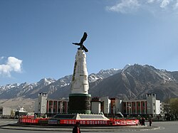
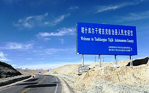
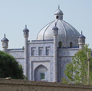
Tashkurgan is a town in the far west of China, close to the country's border with Tajikistan. It is seat of Tashkurgan Tajik Autonomous County, in the autonomous region of Xinjiang. Chinese Tajiks – ethnic Pamiris who live in the Pamir Mountains of Xinjiang – make up a little over half of Tashkurgan's population.

<span class="mw-page-title-main">Artux</span> County-level city in Xinjiang, China

Artux, Artush or Atush is a county-level city and the capital of Kizilsu Kyrgyz Autonomous Prefecture in Xinjiang, China. The government seat is in Guangming Road Subdistrict. As of 2018, it has a population of 285,507 people, 81.4 per cent of whom are Uyghurs.

<span class="mw-page-title-main">Kashgar Prefecture</span> Prefecture in Xinjiang, China

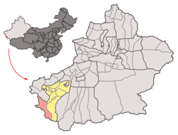
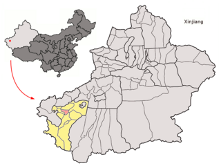
Kashgar Prefecture, also known as Kashi Prefecture, is located in southwestern Xinjiang, China, located in the Tarim Basin region. It has an area of 112,057 km2 (43,265 sq mi) and 4,496,377 inhabitants at the 2020 census with a population density of 35.5 inhabitants/km2. The capital of the prefecture is the city of Kashgar which has a population 506,640.

<span class="mw-page-title-main">Poskam County, Xinjiang</span> County in Xinjiang, China

Poskam County, also Zepu County is a county in Kashgar Prefecture, Xinjiang Uyghur Autonomous Region, China. The county is located on the southern bank of the Yarkand River, also known as the Zarafshān River (泽勒普善河). Poskam County is bordered to the north and west across the Yarkand River by Yarkant County (Shache) and to the south and east by Kargilik County (Yecheng).

<span class="mw-page-title-main">Kargilik County</span> County in Xinjiang, China

Kargilik County, also known as Yecheng County, is a county in southwest of the Xinjiang Uyghur Autonomous Region and is under the administration of the Kashgar Prefecture. It contains an area of 28,600 km². To the north, the county borders Makit County. To the east, the county borders Guma County (Pishan) in Hotan Prefecture. To the west, the county borders Yarkant County, Poskam County and Taxkorgan Tajik Autonomous County. In the south, the county has a border of more than 80 km (50 mi) with Pakistan and India administered areas of Kashmir.

<span class="mw-page-title-main">Yopurga County</span> County in Xinjiang, China

Yopurga County is a county in northern Kashgar Prefecture, Xinjiang Uyghur Autonomous Region. More than 96% of the residents of the county are Uyghurs and live around oases at the western edge of the desolate Taklamakan Desert. The county is bordered to the north by Jiashi County, to the east by Maralbexi County, to the west by Shule County, to the southwest by Yengisar County and to the south by Yarkant County.

<span class="mw-page-title-main">Makit County</span> County in Xinjiang, China

Makit County is a county in Kashgar Prefecture, Xinjiang Uyghur Autonomous Region, China. It contains an area of 10,927 km2 (4,219 sq mi). The Yarkand River passes through the county. The county is bordered to the north by Maralbexi County, to the east by Guma County (Pishan) in Hotan Prefecture, to the west by Yarkant County, and to the south by Kargilik County.

<span class="mw-page-title-main">Akto County</span> County in Xinjiang, China

Akto County is a county in Kizilsu Kyrgyz Autonomous Prefecture, Xinjiang Uygur Autonomous Region, China. The county borders Tajikistan and Kyrgyzstan and has two towns, 11 townships, four state-owned farms and a plant nursery under its jurisdiction with the county seat being Akto Town. The county contains an area of 24,555 km2 (9,481 sq mi) and has a population of 221,526 as of 2015, of 231,756 as of 2017.

<span class="mw-page-title-main">Qiemo County</span> County in Xinjiang, China

Qiemo County as the official romanized name, also transliterated from Uyghur as Qarqan County, is a county under the administration of the Bayin'gholin Mongol Autonomous Prefecture in the Xinjiang Uyghur Autonomous Region of the People's Republic of China, bordering the Tibet Autonomous Region to the south. Its area is 138,645 square kilometers (53,531 sq mi) and, according to the 2002 census, it has a population of 60,000. The county seat is at Qiemo Town.

<span class="mw-page-title-main">Hotan County</span> County in Xinjiang, China

Hotan County is a county in the southwest of the Xinjiang Uyghur Autonomous Region and is under the administration of the Hotan Prefecture. Almost all the residents of the county are Uyghurs and live around oases situated between the desolate Taklamakan Desert and Kunlun Mountains. Hotan County is the southernmost county-level division of Xinjiang. The county borders Karakax/Moyu County to the northwest, Hotan City and Lop County to the northeast, Qira County to the east, Pishan County to the west, and Rutog County, Tibet to the southeast. Hotan County administers most of Aksai Chin, an area disputed between China and India. The Line of Actual Control divides the India-controlled part of Ladakh union territory from the Aksai Chin area administered as part of southwest Hotan County.

<span class="mw-page-title-main">Pishan County</span> County in Xinjiang, China

Pishan County as the official romanized name, also transliterated from Uyghur as Guma County, is a county within the Xinjiang Uyghur Autonomous Region and is under the administration of the Hotan Prefecture. It contains an area of 39,412 km2 (15,217 sq mi). According to the 2002 census, it has a population of 220,000. The county borders Maralbexi County and Makit County to the north, Karakax County, Hotan County and Kunyu to the east and Kargilik County to the west. The county includes lands near the Karakoram Pass which are part of the Aksai Chin area that is disputed between China and India.

<span class="mw-page-title-main">Dafdar</span> Township in Xinjiang, Peoples Republic of China

Dafdar, also spelled Daftar, is a township in the Taghdumbash Pamir located in Tashkurgan Tajik Autonomous County, Kashgar Prefecture, Xinjiang Uyghur Autonomous Region, China. The township is located near the China–Pakistan border. The southern part of the township is located in the Trans-Karakoram Tract claimed by India.

<span class="mw-page-title-main">Bulungkol</span> Township in Xinjiang, Peoples Republic of China

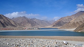
Bulungkol Township is a township of Akto County in Xinjiang, China. Located in the middle west of the county, the township covers an area of 4,585 square kilometers with a population of 7,133. It has 5 administrative villages under its jurisdiction. Its seat is at Bulungkol Village (布伦口村).

Tar Tajik Township is an ethnic township for Chinese Tajiks in Akto County, in Xinjiang, China. Located in the southernmost part of the county, the township covers an area of 1,009.7 square kilometers with a population of 5,408. It has 8 administrative villages under its jurisdiction. Its seat is Bag Village (巴格村).

Kosrap Township is a historic township of Akto County in Xinjiang Uygur Autonomous Region, China. It ceased to exist as a township and its territory was amalgamated to Qarlung Township on August 27, 2018. All the residents of the former Kosrap Township migrated to Dayasdun (大亚斯墩) in Zepu County. Meanwhile, the Tong'an Township (桐安乡) was established in Dayasdun of Zepu County on August 27, 2018, its seat ia at Yengavati Village (英阿瓦提村).

Muji is a town in Pishan/Guma County, Hotan Prefecture, Xinjiang, China.

Pixna is a town in Pishan/Guma County, Hotan Prefecture, Xinjiang, China.

Jiya is a township in the northeastern part of Hotan City in Hotan Prefecture, Xinjiang, China in an oasis area on the eastern bank of the White Jade River in the southwestern part of the Taklamakan Desert. To the north and east, Jiya borders Lop County, the county which Jiya was a part of until 2006, and to the south and west, Jiya borders the rest of Hotan city.

References

  1. 1 2 3 4 5 6 7 8 9 10 11 12 塔县政府办公室 (2019-12-15). 塔什库尔干塔吉克自治县基本概况 [Taxkorgan Tajik Autonomous County Basic Overview]. 塔什库尔干政府门户网站 (in Simplified Chinese). Archived from the original on 2020-02-09. Retrieved 2020-02-09. 全县总面积2.5万平方公里,辖12个乡镇50个村(社区),总人口4.1万人,塔吉克族占80.9%,是全国唯一的塔吉克民族自治县,外与巴基斯坦、阿富汗、塔吉克斯坦及克什米尔地区接壤,边境线长793.6公里,
  2. Xinjiang: Prefectures, Cities, Districts and Counties
  3. 壮阔之美●新疆帕米尔高原. 塔什库尔干政府门户网站 (in Simplified Chinese). 24 December 2018. Retrieved 9 February 2020. 主要居民为塔吉克族。
  4. Gao, Erqiang (高尔锵) (1996). 塔吉克汉词典 [Tajik-Chinese Dictionary] (in Simplified Chinese). Sichuan Nationalities Publishing House (四川民族出版社). ISBN   978-7-5409-1744-9.
  5. 中国地名委员会 (1994). 《中华人民共和国地名录》. Beijing: 中国社会出版社. p. 706.
  6. 崔乃夫 (Cui Naifu). 中华人民共和国分省地图集. p. 122.
  7. 《中华人民共和国地名大词典》. Beijing: The Commercial Press. 2002. p. 6534.
  8. See the discussions in Hill, John E. (2009) Through the Jade Gate to Rome: A Study of the Silk Routes during the Later Han Dynasty, 1st to 2nd Centuries CE. BookSurge, Charleston, South Carolina. ISBN   978-1-4392-2134-1, Note 20.2, pp. 394-401.
  9. 1 2 夏征农; 陈至立, eds. (September 2009). 辞海:第六版彩图本[ Cihai (Sixth Edition in Color)] (in Chinese). 上海. Shanghai: 上海辞书出版社. Shanghai Lexicographical Publishing House. p. 2189. ISBN   9787532628599.
  10. 1 2 Xie Yuzhong 解玉忠 (2003). 地名中的新疆 (in Simplified Chinese). Ürümqi: 新疆人民出版社. p. 193. ISBN   7-228-08004-1.
  11. "Zoroastrian Cemetery found in Xinjiang, Tashkurgan Tajik Autonomous County, Jirzankal, 2013". kaogu.cn. Translated by Grace Warren. Institute of Archaeology, Chinese Academy of Social Sciences. 26 October 2013. Retrieved 21 January 2020.
  12. Zhang, Dongmiao (2017-05-12). "8 dead, 29 injured in Xinjiang's 5.5-magnitude earthquake". www.xinhuanet.com. Xinhua News Agency. Archived from the original on 2021-06-10. Retrieved 2021-06-10.
  13. 家乡“塔什库尔干县”微名片. 塔什库尔干政府门户网站 (in Simplified Chinese). 24 December 2018. Archived from the original on 19 April 2020. Retrieved 20 April 2020. 塔什库尔干自治县辖1镇、10乡、1场:塔什库尔干镇、塔什库尔干乡、提孜那甫乡、塔合曼乡、柯克亚柯尔克孜民族乡、达布达尔乡、库克西力克乡、班迪尔乡、瓦恰乡、马尔洋乡、大同乡、麻扎种羊场。
  14. 2018年统计用区划代码和城乡划分代码:塔什库尔干塔吉克自治县 (in Simplified Chinese). National Bureau of Statistics of the People's Republic of China. 2018. Retrieved 9 February 2020. 统计用区划代码 名称 653131100000 塔什库尔干镇 653131101000 塔吉克阿巴提镇 653131200000 塔什库尔干乡 653131201000 塔合曼乡 653131202000 科克亚尔柯尔克孜族乡 653131203000 提孜那甫乡 653131204000 达布达尔乡 653131205000 马尔洋乡 653131206000 瓦恰乡 653131207000 班迪尔乡 653131208000 库科西鲁格乡 653131210000 大同乡
  15. 1 2 塔什库尔干县历史沿革 [Taxkorgan County Historical Evolution]. XZQH.org (in Simplified Chinese). 14 November 2014. Retrieved 11 May 2020. 2000年第五次人口普查,塔什库尔干塔吉克自治县常住总人口30454人{...}2010年第六次人口普查,塔什库尔干塔吉克自治县常住总人口37843人
  16. 1 2 3 4 3-7 各地、州、市、县(市)分民族人口数 [3-7 Population by Nationality by Prefecture, Prefecture, City and County (City)] (in Chinese). Statistical Bureau of Xinjiang Uygur Autonomous Region. 2020-06-10. Archived from the original on 2020-11-01. Retrieved 2021-06-10.
  17. 1 2 3 3-7 各地、州、市、县(市)分民族人口数 [3-7 Population by Nationality by Prefecture, Prefecture, City and County (City)] (in Simplified Chinese). شىنجاڭ ئۇيغۇر ئاپتونوم رايونى新疆维吾尔自治区统计局 Statistic Bureau of Xinjiang Uygur Autonomous Region. 2017-03-15. Archived from the original on 2017-10-11. Retrieved 2021-06-10.
  18. Morris Rossabi, ed. (2004). Governing China's Multiethnic Frontiers (PDF). University of Washington Press. p. 179. ISBN   0-295-98390-6.
  19. "The mountainous task of getting to school". China Daily . 30 September 2011. Retrieved 20 April 2020.
  20. 塔什库尔干县召开314国道项目复工复产达产现场推进会 [Taxkorgan County held a site promotion meeting for the resumption of production and production of the 314 National Highway project]. www.tskeg.gov.cn (in Chinese). Taxkorgan Tajik Autonomous County People's Government. 2020-04-18. Archived from the original on 2020-06-06. Retrieved 2021-06-10.
  21. 张涵. "In pics: construction site of Taxkorgan Airport in Xinjiang - Xinhua | English.news.cn". www.xinhuanet.com. Archived from the original on October 29, 2020. Retrieved 2020-10-26.