List of earthquakes in Cuba

Last updated

Map showing regional tectonic setting of the Oriente fault zone Gonave microplate.png
Map showing regional tectonic setting of the Oriente fault zone

Cuba is located in an area with several active fault systems which produce on average about 2000 seismic events each year. [1] While most registered seismic events pass unnoticed, the island has been struck by a number of destructive earthquakes over the past four centuries, including several major quakes with a magnitude of 7.0 or above.

Contents

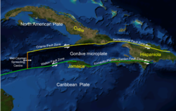
Approximately 70% of seismic activity in Cuba emanates from the Oriente fault zone, located in the Bartlett-Cayman fault system which runs along the south-eastern coast of Cuba and marks the tectonic boundary between the North American Plate and the Caribbean Plate. [2] The 12 currently active faults in Cuba also include the Cauto-Nipe, Cochinos and Nortecubana faults. [2] Destructive earthquakes originating from the Oriente fault occurred in 1766 (MI = 7.6), 1852 (MI = 7.2) and 1932 (Ms = 6.75). [3] Some studies suggested there is a high probability the Oriente fault would produce a magnitude 7 earthquake, [4] this happening in January 2020, with a magnitude of 7.7, the highest registered in this country's history.

Notable earthquakes in recent Cuban history include the following:

NameDateEpicentreMIntensityDepthNotesDeaths
1578 Cuba earthquake August 1578
Santiago de Cuba [1] 6.8VIII30 kmMagnitude estimated at 6.8 ML on the Richter magnitude scale, intensity at VIII EMS-98. [1]
1580 Cuba earthquake 1580-12-19
Santiago de Cuba [5]
1632 Cuba earthquake October 1632
Santiago de Cuba [6]
1675 Cuba earthquake 1675-02-11
Santiago de Cuba [1] [7] 5.8VII30 kmMagnitude estimated at 5.8 ML on the Richter magnitude scale, intensity at VII EMS-98. [1]
1678 Cuba earthquake 1678-02-11
14:59
Santiago de Cuba [7] 6.8VIII30 kmMagnitude estimated at 6.8 ML on the Richter magnitude scale, intensity at VIII EMS-98. [1]
1679 Cuba earthquake 1679-02-11
Santiago de Cuba [7]
1682 Cuba earthquake 1682
Santiago de Cuba [7] 5.8VII30 kmMagnitude estimated at 5.8 ML on the Richter magnitude scale, intensity at VII EMS-98. [1]
1693 Cuba earthquake July 1693
Havana [8] "1,500 houses thrown down"
1757 Cuba earthquake 1757-12-14
Santiago de Cuba [9]
1766 Cuba earthquake 1766-06-11
05:14
Santiago de Cuba [10] 7.6 MI [3] IX35 kmMagnitude estimated at 7.6 ML on the Richter magnitude scale, intensity at IX EMS-98. [1] 120
1826 Cuba earthquake 1826-09-18
09:26
Santiago de Cuba [11] 5.8VII30 kmMagnitude estimated at 5.8 ML on the Richter magnitude scale, intensity at VII EMS-98. [1]
1842 Cuba earthquake 1842-07-07
Santiago de Cuba [1] 6.0VII30 kmMagnitude estimated at 6.0 ML on the Richter magnitude scale, intensity at VII EMS-98. [1]
1852 Cuba earthquake 1852-08-20
14:05 UTC
Santiago de Cuba [10] [12] 7.2 MI [3] IX30 kmIntensity estimated at IX EMS-98, [1] with 26 heavy aftershocks. Caused severe damage to churches and other buildings in Santiago de Cuba, as well as landslides in the Sierra Maestra region. Shaking felt in the whole of eastern Cuba, up to the islands of Jamaica and Hispaniola. [13]
1852 Cuba earthquake (November) 1852-11-26
08:37 GMT
Santiago de Cuba, Sierra Maestra [1] [14] 7.0VIII35 km
1858 Cuba earthquake 1858-01-28
22:04
Santiago de Cuba [1] 6.5VII30 km
1880 Cuba earthquake 1880-01-23
04:39
San Cristóbal/Vuelta Abajo (Pinar del Río) [1] [15] [16] 6.0VIII15 kmA series of severe shock waves originating from western Cuba were also felt in the town of Key West (Florida), and included a strong earthquake on 23 January 1880 in San Cristóbal, Pinar del Río at 4 a.m. [16]
1903 Cuba earthquake 1903-09-22
08:09
Santiago de Cuba [1] 5.7VII30 km
1906 Cuba earthquake 1906-06-22
07:09
Santiago de Cuba [1] 6.2VII30 km
1914 Cuba earthquake 1914-02-28
05:19
Gibara [1] 6.2VII32 km
1914 Cuba earthquake 1914-12-25
05:19
Santiago de Cuba [1] 6.7VII30 km
1932 Cuba earthquake 1932-02-03
20°00′00″N75°48′00″W / 20.000°N 75.800°W / 20.000; -75.800
Santiago de Cuba [17]
6.75 mb [3] VIIIIntensity estimated at VIII EMS-98. [1] 8 [17] – 1500 [18] deaths, 300 injured. 80% of buildings in Santiago de Cuba affected., [17] with damage totaling 15 million Pesos. [13] 8
1947 Cuba earthquake 1947-08-07
00:40:20 UTC
19°45′N75°19′W / 19.75°N 75.32°W / 19.75; -75.32

Santiago de Cuba [19]

6.8VIII50 kmMagnitude estimated at 6.8 ML and intensity VIII EMS-98. [1]
1992 Cuba earthquake 1992-05-25
16:55:04 UTC
19°36′47″N77°52′19″W / 19.613°N 77.872°W / 19.613; -77.872
Cabo Cruz, Pilón Manzanillo [20]
6.9 Ms [21] VII23 kmA strong earthquake struck the Cabo Cruz sector, leaving 40 people injured and more than 820 buildings damaged in the Pilon-Manzanillo area. [22] -
2020 Caribbean earthquake 2020-01-28

14:10

UTC

19.419°N 78.756°W

Caribbean Sea

7.7 MwVI14.9 kmOne house collapsed and more than 300 were damaged. [23] 0
M = Magnitude on the Richter magnitude scale (ML), except where noted

Intensity= Intensity on the European Macroseismic Scale (EMS-98), which is somewhat similar to the Modified Mercalli scale (MM)

See also

Related Research Articles

<span class="mw-page-title-main">Seismology</span> Scientific study of earthquakes and propagation of elastic waves through a planet

Seismology is the scientific study of earthquakes and the generation and propagation of elastic waves through the Earth or other planetary bodies. It also includes studies of earthquake environmental effects such as tsunamis as well as diverse seismic sources such as volcanic, tectonic, glacial, fluvial, oceanic microseism, atmospheric, and artificial processes such as explosions and human activities. A related field that uses geology to infer information regarding past earthquakes is paleoseismology. A recording of Earth motion as a function of time, created by a seismograph is called a seismogram. A seismologist is a scientist works in basic or applied seismology.

<span class="mw-page-title-main">Intraplate earthquake</span> Earthquake that occurs within the interior of a tectonic plate

An intraplate earthquake is an earthquake that occurs in the interior of a tectonic plate, in contrast to an interplate earthquake on the boundary of a tectonic plate. It is also called an intraslab earthquake, especially when occurring in a microplate.

A blind thrust earthquake occurs along a thrust fault that does not show signs on the Earth's surface, hence the designation "blind". Such faults, being invisible at the surface, have not been mapped by standard surface geological mapping. Sometimes they are discovered as a by-product of oil exploration seismology; in other cases their existence is not suspected.

Megathrust earthquakes occur at convergent plate boundaries, where one tectonic plate is forced underneath another. The earthquakes are caused by slip along the thrust fault that forms the contact between the two plates. These interplate earthquakes are the planet's most powerful, with moment magnitudes (Mw) that can exceed 9.0. Since 1900, all earthquakes of magnitude 9.0 or greater have been megathrust earthquakes.

<span class="mw-page-title-main">Okhotsk microplate</span> Minor tectonic plate in Asia

The Okhotsk microplate is a proposed minor tectonic plate covering the Kamchatka Peninsula, Magadan Oblast, and Sakhalin Island of Russia; Hokkaido, Kantō and Tōhoku regions of Japan; the Sea of Okhotsk, as well as the disputed Kuril Islands.

The 1938 Banda Sea earthquake occurred on February 2 with an estimated magnitude of 8.5–8.6 on the moment magnitude scale and a Rossi–Forel intensity of VII. This oblique-slip event generated destructive tsunamis of up to 1.5 metres in the Banda Sea region, but there were no deaths.

<span class="mw-page-title-main">New Hebrides Plate</span> Minor tectonic plate in the Pacific Ocean near Vanuatu

The New Hebrides Plate, sometimes called the Neo-Hebridean Plate, is a minor tectonic plate located in the Pacific Ocean. While most of it is submerged as the sea bottom of the North Fiji Basin, the island country of Vanuatu, with multiple arc volcanoes, is on the western edge of the plate. It is bounded on the south-west by the Australian Plate, which is subducting below it at the New Hebrides Trench. The Vanuatu subduction zone is seismically active, producing many earthquakes of magnitude 7 or higher. To its north is the Pacific Plate, north-east the Balmoral Reef Plate and to its east the Conway Reef Plate.

The 2009 Swan Islands earthquake occurred on May 28 at 02:24:45 AM local time with a moment magnitude of 7.3 and a maximum Mercalli intensity of VII. The epicenter was located in the Caribbean Sea, 64 kilometres (40 mi) northeast of the island of Roatán, 19 miles northeast of Port Royal, Isla de Bahias, 15 miles northwest of Isla Barbaretta, and 130 kilometres (81 mi) north-northeast of La Ceiba. Three aftershocks followed the earthquake within magnitude 4 range.

<span class="mw-page-title-main">Enriquillo–Plantain Garden fault zone</span> Seismic fault in the Caribbean

The Enriquillo–Plantain Garden fault zone is a system of active coaxial left lateral-moving strike slip faults which runs along the southern side of the island of Hispaniola, where Haiti and the Dominican Republic are located. The EPGFZ is named for Lake Enriquillo in the Dominican Republic where the fault zone emerges, and extends across the southern portion of Hispaniola through the Caribbean to the region of the Plantain Garden River in Jamaica.

<span class="mw-page-title-main">Septentrional-Oriente fault zone</span> Faults that runs along Hispaniola, Haiti, the Dominican Republic, and Cuba

The Septentrional-Orient fault zone (SOFZ) is a system of active coaxial left lateral-moving strike slip faults that runs along the northern side of the island of Hispaniola where Haiti and the Dominican Republic are located and continues along the south of Cuba along the northern margin of the Cayman Trough. The SOFZ shares approximately half of the relative motion between the North American and Caribbean tectonic plates with the Enriquillo-Plantain Garden fault zone and Walton fault zone which run along the southern side of Hispaniola and aong the southern margin of the Cayman Trough. Both fault zones terminate at the Mid-Cayman Rise to the west. Some researchers believe that the Enriquillo-Plantain Garden fault zone and the SOFZ bound a microplate, dubbed the Gonâve Microplate, a 190,000 km2 (73,000 sq mi) area of the northern Caribbean Plate that is in the process of shearing off the Caribbean Plate and accreting to the North America Plate.

<span class="mw-page-title-main">Awatere Fault</span>

The Awatere Fault is an active dextral strike-slip fault in the northeastern part of South Island, New Zealand. It forms part of the Marlborough Fault System, which accommodates the transfer of displacement along the oblique convergent boundary between the Indo-Australian Plate and Pacific Plate, from the transform Alpine Fault to the Hikurangi Trench subduction zone. The 1848 Marlborough earthquake was caused by rupture of the whole of the eastern section of the Awatere Fault.

The 1842 Cap-Haïtien earthquake occurred at 17:00 local time on 7 May. It had an estimated magnitude of 8.1 on the Ms scale and triggered a destructive tsunami. It badly affected the northern coast of Haiti and part of what is now the Dominican Republic. Port-de-Paix suffered the greatest damage from both earthquake and tsunami. Approximately 5,000 people were killed by the effects of the earthquake shaking and another 300 by the tsunami.

The geology of Cuba differs significantly from that of other Caribbean islands because of ancient 900 million year old Precambrian Proterozoic metamorphic rocks in the Santa Clara province and extensive Jurassic and Cretaceous outcrops.

<span class="mw-page-title-main">2020 Caribbean earthquake</span> Earthquake between Jamaica and Cuba

At 2:10 p.m. local time (UTC-5) on 28 January 2020, an earthquake of 7.7 Mw struck on the north side of the Cayman Trough, north of Jamaica and west of the southern tip of Cuba, with the epicenter being 80 miles (130 km) ESE of Cayman Brac, Cayman Islands or 83 miles (134 km) north of Montego Bay, Jamaica. Schools in Jamaica and buildings in Miami were evacuated after shaking was observed in parts of the U.S. state of Florida. Light shaking was also reported on the Yucatan peninsula in Mexico. It is the largest earthquake in the Caribbean since 1946. A tsunami warning for the Caribbean Sea was issued by the Pacific Tsunami Warning Center and later withdrawn.

The 1139 Ganja earthquake was one of the worst seismic events in history. It affected the Seljuk Empire and Kingdom of Georgia; modern-day Azerbaijan and Georgia. The earthquake had an estimated magnitude of 7.7 MLH, 7.5 Ms and 7.0–7.3 Mw. A controversial death toll of 230,000–300,000 came as a consequence of this event.

The 1604 Quanzhou earthquake was an extremely large seismic event that occurred in the Taiwan Strait, off the coast of Fujian Province, near Quanzhou during the Ming dynasty. According to modern-day calculations, the earthquake had a moment magnitude of 8.1 Mw. It is unknown how many casualties resulted from the quake, but major damage was reported.

The southern part of Cuba was struck by a major earthquake on 12 June 1766 at midnight local time. It had an estimated magnitude of 6.8 Ms and a maximum felt intensity of IX (destructive) on the MSK scale. Its epicenter was offshore, near Santiago de Cuba, with a focal depth of 25 km. Santiago de Cuba suffered the worst damage, although large areas of Cuba were affected. It was felt in both Havana and on Jamaica. Between 34 and 40 people died and a further 700 were injured.

The 1706 Abruzzo earthquake, also known as the Maiella earthquake, occurred on November 3 at 13:00 CEST. The earthquake with a possible epicenter in the Central Apennine Mountains (Maiella), Abruzzo had an estimated moment magnitude of 6.6–6.84 Mw . It was assigned a maximum Mercalli intensity of XI (Extreme), causing tremendous destruction in Valle Peligna. At least 2,400 people were killed.

References

  1. 1 2 3 4 5 6 7 8 9 10 11 12 13 14 15 16 17 18 19 20 21 Oficina Nacional de Estadísticas, 2009
  2. 1 2 Cotilla, 2007
  3. 1 2 3 4 Alvarez 1999:2
  4. Rubio, 1985
  5. Milne, 1912: 30
  6. Milne, 1912: 32
  7. 1 2 3 4 Milne, 1912: 36
  8. Milne, 1912: 37
  9. Milne, 1912: 44
  10. 1 2 Cotilla, 2003
  11. Milne, 1912: 54
  12. Milne, 1912: 62
  13. 1 2 ONE, 2006
  14. Milne 1912: 63
  15. Milne 1912: 80
  16. 1 2 "Florida. Earthquake History" . Retrieved 2010-01-25.
  17. 1 2 3 "Significant Earthquake". National Geophysical Data Center. Retrieved 2010-01-25.
  18. Earthquake in Cuba. 1500 Deaths reported. The Sidney Morning Herald, Feb. 4, 1932.
  19. A Chronological History of the U.S. Navy Cruiser U.S.S. LITTLE ROCK
  20. USGS. "Significant Earthquakes of the World, 1992" . Retrieved 2010-01-25.
  21. Pierrot et al, 1998
  22. "Earthquake in Cuba Injures 40 and Destroys 100 Homes (Published 1992)". The New York Times . Archived from the original on 2021-03-23.
  23. OnCuba Staff (4 February 2020). "Earthquake-damaged buildings in Cuba were in "poor condition"". On Cuba News. Retrieved 27 November 2020.

Other sources