City Mall, Christchurch

Last updated

City Mall
Cashel Street west seen from Colombo.jpg
The Cashel Street part of City Mall looking west as seen from Colombo Street in 2009
Former name(s)Cashel Street and High Street
Maintained byChristchurch City Council
Width20 m
Location Christchurch Central City
Coordinates 43°31′57.28″S172°38′14.69″E / 43.5325778°S 172.6374139°E / -43.5325778; 172.6374139
Construction
Construction start1982
Inauguration7 August 1982

City Mall is the main pedestrian mall in the central city of Christchurch, New Zealand, comprising two sections of Cashel Street plus the Bridge of Remembrance and one section of High Street. It is also known colloquially as Cashel Mall. [1] [2] [3] [4] The Bridge of Remembrance was pedestrianised in 1976. The main mall was closed to traffic on 11 January 1982 and formally reopened as a pedestrian mall on 7 August, but it was not until 1992 that the entire mall was paved. The mall was redeveloped between 2006 and 2009, and track was installed for an expansion of the heritage tram network.

Contents

The September 2010 Canterbury earthquake caused damage to some buildings, but the Boxing Day aftershock, directly underneath the city, caused even more damage, including building failures. The 6.3 magnitude February 2011 Christchurch earthquake devastated the mall; the façades of many buildings collapsed and there were several fatalities. The centre of the city was subsequently closed to allow demolition work to proceed. Structures affected included most of the heritage buildings in the mall that are or were registered by Heritage New Zealand. Part of City Mall, the section of Cashel Street from Oxford Terrace to Colombo Street, was the first part of the central city to open again, on Saturday, 29 October 2011, marked by a ceremony at which the Prime Minister John Key officiated.

Urban context

Looking down High Street from its intersection with Colombo and Hereford Streets, with part of the former Stewart Fountain in the foreground (2007) High Street, Christchurch, NZ.jpg
Looking down High Street from its intersection with Colombo and Hereford Streets, with part of the former Stewart Fountain in the foreground (2007)
Looking down High Street from its intersection with Colombo and Hereford Streets (c. 1910) Colombo Hereford High intersection.jpg
Looking down High Street from its intersection with Colombo and Hereford Streets (c. 1910)

City Mall is made up of Cashel Street between Cambridge Terrace up to its intersection with High Street and High Street from Cashel Street to its intersection with Hereford and Colombo Streets. [5]

Cashel Street runs east–west. The portion of Cashel Street that makes up City Mall is approximately 400 metres (1,300 ft) long. The street is named after the bishopric of Cashel. At the time of naming by surveyor Edward Jollie and Joseph Thomas, the bishop was Robert Daly, an uncle of John Robert Godley, who is considered to be the founder of Canterbury. [6] [7]

High Street is one of the two diagonal streets in the central city, running from north-west to south-east. The portion of High Street that makes up City Mall is approximately 150 metres (490 ft) long. It was initially called Sumner Road, as it connected to the village (and later suburb) of Sumner. It was renamed Lower High Street, and then just High Street, probably after The High in Oxford. [8]

History

The first traffic lights in the South Island were installed at the intersection of Cashel and Colombo Streets. [9] The traffic lights, which were first tested on the evening of 5 November 1930, replaced officers on point duty. [lower-alpha 1] [10] [11]

The Canterbury/Westland Branch of the New Zealand Institute of Valuers began biannual pedestrian counts in central Christchurch in 1957. The count takes place one hour in the morning and afternoon, respectively (10:30h to 11:30h and 14:30h to 15:30h). While dozens of sites are counted, only seven of the locations have been included in the count since the work began in the 1950s. There is a gradual but steady decline visible in pedestrian numbers. The seven sites had 30,000 pedestrians in 1957, and that had reduced to 18,000 by the 1981 count. The establishment of City Mall saw the numbers increase to 25,000 again, but the overall downward trend continued after that, albeit starting at the higher level of the 1983 count. [12]

Original scheme

Cashel Street as seen from Oxford Terrace in 2005 Cashel Street, Christchurch, 2005.jpg
Cashel Street as seen from Oxford Terrace in 2005

The concept of a pedestrian mall in Cashel and High Streets was first developed in the 1965 central city redevelopment study. [5] In the same year, there were proposals in Wellington to form a pedestrian mall in Cuba Street. [13] The Christchurch concept was included in the 1968 District Scheme (a predecessor of the Christchurch City Plan). [5] A year later, Cuba Mall was established in Wellington, the success of which gave other cities the confidence to advance their plans for pedestrianising streets. [13] In 1976, the Bridge of Remembrance was closed to traffic, reserving the short Cashel Street link between Oxford and Cambridge Terraces over the Avon River / Ōtākaro for pedestrians. [14] The plans for City Mall were confirmed in the 1979 review of the District Scheme. A concept design by the City Architect was adopted by Christchurch City Council, the Cashel Street Businessmen's Association and the High Street Businessmen's Association in 1981. [5]

On 11 January 1982, the sections of Cashel and High Street that form the mall were closed to traffic. Mayor Hamish Hay opened the NZ$0.5m City Mall project on 7 August 1982. [5] It took ten years and three separate project stages before the whole area was paved; [15] tree planters and additional seating were installed as part of the final project stage in the early 1990s. Mayor Vicki Buck opened the third and final stage on 4 December 1992. [5]

In 1998, Christchurch City Council redeveloped the adjacent section of Oxford Terrace, which became known as The Strip, and narrowed the road to a one-way street. It was the prime night-time entertainment hub in Christchurch over the next decade, until increasing competition from newer developments took its toll. [12] [16] Another pedestrian mall in Christchurch inspired by City Mall was New Regent Street, which was closed to traffic in 1994 in preparation for the reintroduction of the Christchurch tram. [17]

2007–2009 redevelopment

Redevelopment of City Mall in March 2009 (the building on the left is 93 Cashel Street) Cashel Mall, Christchurch.jpg
Redevelopment of City Mall in March 2009 (the building on the left is 93 Cashel Street)
Mayor Bob Parker and the mayoress opening the redeveloped City Mall City Mall opening speech.jpg
Mayor Bob Parker and the mayoress opening the redeveloped City Mall

During 2006, the public were invited to comment on the proposed redevelopment plans for City Mall. The Council approved the final proposals in December 2006 and agreed an implementation plan, for which NZ$10.5 million had been budgeted, [18] but on which NZ$14 million was spent. [19] An alliance contract was entered into between Christchurch City Council as the client, Isthmus Group as the designer, and Downer EDI Works as the contractor. [18] Mayor Garry Moore and Central City Business Association chairman Antony Gough started the work with a symbolic lifting of the first brick on 10 August 2007. [20]

Christchurch heritage tramway circuit with extensions through City Mall Christchurch heritage tramway circuit with extensions.png
Christchurch heritage tramway circuit with extensions through City Mall

A separate project that affected the City Mall redevelopment was the extension of the heritage tramway. From the previous circuit on Worcester Street, the extension would see the trams turn left into Oxford Terrace (The Strip), and then left into the Cashel Street part of City Mall. At the intersection with High Street, trams would turn south-east towards Lichfield Street. On the return journey, trams would travel north-west along High Street, including the City Mall part of it. The $10.8 million project, to be funded from grants and from borrowing, was due to be completed in the 2013/14 financial year. [21]

The redevelopment was not without controversy. Young people protested strongly about the demolition of Hack Circle on the corner of Cashel and High Streets, as it was seen as an attempt to push them out of City Mall. Antony Gough, owner of several properties along The Strip, [22] was an advocate of stronger security for City Mall, particularly the Hack Circle, telling The Press that the people who associate there "are just very scary". [23] Police arrested several young people during the mall redevelopment, including 13 teenagers when the demolition of Stewart Fountain began. [24] [25]

Aerial view of Cashel Street looking east on 29 September 2011, with the Bridge of Remembrance is in the centre of the photo and the temporary container mall under construction Cashel Street in September 2011.jpg
Aerial view of Cashel Street looking east on 29 September 2011, with the Bridge of Remembrance is in the centre of the photo and the temporary container mall under construction

The second Stewart Fountain, replacing an earlier fountain, was built in 1998 at a cost of NZ$700,000, with a NZ$200,000 contribution by industrialist Sir Robertson Stewart and decorated with hundreds of tiles painted by Christchurch schoolchildren. Demolition of the fountain began on 13 August 2007 and 13 young people were arrested in the resulting demonstration; Sir Robertson Stewart had died that morning. [25] [26] Christchurch City Council formally named the reserve Stewart Plaza in 2008. Stewart's bequest part-funded the replacement sculpture, "Flour Power", on the condition that the installation be permanent, and that the land be known as Stewart Plaza. [27]

Another controversial issue was the slow road through High Street. Despite opposition from 70% of those who had taken part in the public consultation, the Council confirmed that the slow road would go ahead. [28] The upgraded City Mall was opened by mayor Bob Parker on 18 December 2009. [19]

2010 and 2011 earthquakes

John Key and Re:START chairman John Suckling cutting the ribbon John Key and John Suckling 27.jpg
John Key and Re:START chairman John Suckling cutting the ribbon

The central city was closed for a week after the 7.1 magnitude earthquake on 4 September 2010; some buildings were damaged, including parapets collapsing. The central city experienced peak ground acceleration (i.e. earthquake intensity) of between 15% and 20% of gravity. [29] Ongoing aftershocks and cracked building façades dented confidence in the central city. Retailers in the City Mall retailers had put an effort into strongly promoting the traditional Boxing Day sales in 2010, and there was "brisk trade" until an aftershock at 10.30 am. Although only a 4.9 magnitude earthquake, its epicentre was directly beneath the central city and the resulting peak ground acceleration ranged from 22% of gravity at ChristChurch Cathedral and 48% at Christchurch Botanic Gardens. [29] [30] The Last Train to India restaurant at 94 Cashel Street was a graphic example of the damage caused. The wall of the adjacent former Zetland Hotel collapsed and crashed through the roof; anybody standing in the restaurant's bar area would likely have been killed, but it was still closed that morning. [31] [32]

City Mall on re-opening day City Mall opening 32.jpg
City Mall on re-opening day
Re:START City Mall ReSTART City Mall Christchurch 2013.jpg
Re:START City Mall

Damage caused by the 22 February 2011 Christchurch earthquake was much more severe. Although its 6.3 magnitude was lower than the September 2010 event, it was much closer to the central city and caused the loss of many buildings. The peak ground acceleration reached 180% of gravity in the city. [33] Four people died in Cashel Street in the section between Oxford Terrace and Colombo Street, and one person died in the High Street part of City Mall, all of them killed by falling masonry. [34] The central city was cordoned off on 22 February while demolitions were underway. [35] [36]

In April 2011, it was announced that part of Cashel Street was to reopen on 29 October 2011. [37] Temporary shops made from shipping containers were fitted out as retail premises, accommodating 27 shops known as Re:START. [38] Ballantynes, Christchurch's remaining department store, also reopened and is the retail anchor. Prime Minister John Key officiated at the opening ceremony. [39]

Organisers initially claimed that it was the world first pop-up mall, [40] [41] but there were already container malls in other places, for example Cholula (Mexico) and Bishkek (Kyrgyzstan). Organisers of the Christchurch mall project were threatened with legal action by organisers of a similar project in London (Boxpark) that was yet to open. [42]

The Canterbury Earthquake Recovery Authority completed the removal of the Red Zone cordon, including removing the remaining cordon around City Mall, in June 2013. [43]

Registered heritage buildings

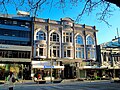
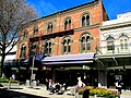
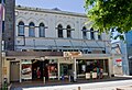
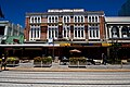
City Mall contains or contained seven structures that are or were registered as historic places by Heritage New Zealand. The following table lists these buildings starting at the Colombo / Hereford / High intersection and proceeding down High Street and then along Cashel Street:

PhotoNameCategoryStatusAddressDescription
Fisher's Building, 28 Feb 2011.jpg Fisher's Building IDemolished280 High StreetCommercial building designed by William Armson [44]
D.I.C. Building, Christchurch.jpg D.I.C. BuildingIIDemolished154–158 Cashel StreetFormer department store building from 1909 [45]
The Crossing, Christchurch.jpg Beaths Department Store BuildingIIStill standing682–690 Colombo Street; corner Cashel StreetPart of the Bus Exchange as of 2011 [46]
Guthrey Centre, 2010.jpg Guthrey Centre IDemolished124–126 Cashel StreetCommercial building from ca. 1881 designed by William Armson [47]
Twentymen & Cousins Store (Former), 93 Cashel Street, CHRISTCHURCH NZHPT Reg 3707.jpg Twentymen & Cousins StoreIIDemolished93 Cashel StreetCommercial building from 1882 [44]
Zetland Hotel, 88-92 Cashel Street, CHRISTCHURCH NZHPT Reg 1952.jpg Zetland HotelIIDemolished88–92 Cashel StreetFormer hotel from 1903; [44] the Last Train to India restaurant is in the low rise on the left
Bridge of Remembrance, Christchurch.jpg Bridge of Remembrance IRepairs completed April 2016Between Oxford and Cambridge TerracesWorld War I war memorial [14]

Notes

  1. In the book Christchurch chronology: a history of settlement, the incorrect installation date of December 1930 is given. [9]

Related Research Articles

<span class="mw-page-title-main">Cathedral Square, Christchurch</span> Square in Christchurch, New Zealand

Cathedral Square, locally known simply as the Square, is the geographical centre and heart of Christchurch, New Zealand, where the city's Anglican cathedral, ChristChurch Cathedral is located. The square stands at the theoretical crossing of the city's two main orthogonal streets, Colombo Street and Worcester Street, though in practice both have been either blocked off or detoured around the square itself. The square was badly damaged in the February 2011 Christchurch earthquake.

<span class="mw-page-title-main">Sydenham, New Zealand</span> Suburb of Christchurch, New Zealand

Sydenham is an inner suburb of Christchurch, New Zealand, two kilometres south of the city centre, on and around the city's main street, Colombo Street. It is a residential, retail and light industrial suburb.

<span class="mw-page-title-main">D.I.C. (department store)</span> Defunct New Zealand department store chain

The D.I.C. was a New Zealand department store chain, founded in Dunedin by Bendix Hallenstein in 1884.

<span class="mw-page-title-main">Christchurch tramway system</span> Tram transport network of Christchurch, New Zealand

The Christchurch tramway system was an extensive network in Christchurch, New Zealand, with steam and horse trams from 1882. Electric trams ran from 1905 to 1954, when the last line from Cashmere to Papanui was replaced by buses.

<span class="mw-page-title-main">Christchurch Central City</span> Central area of Christchurch, New Zealand

Christchurch Central City or Christchurch City Centre is the geographical centre and the heart of Christchurch, New Zealand. It is defined as the area within the Four Avenues and thus includes the densely built up central city, some less dense surrounding areas of residential, educational and industrial usage, and green space including Hagley Park, the Christchurch Botanic Gardens and the Barbadoes Street Cemetery.

<span class="mw-page-title-main">John Anderson (mayor)</span> New Zealand blacksmith and businessman (1820–1897)

John Anderson was the second Mayor of Christchurch in New Zealand 1868–1869, and a successful businessman. He had a close connection with three buildings that have later received Category I heritage registrations by Heritage New Zealand. Two of these buildings were demolished following the February 2011 Christchurch earthquake.

<span class="mw-page-title-main">Colombo Street</span> Main road in Christchurch, New Zealand

Colombo Street is a main road of the city of Christchurch, New Zealand. It runs south-north through the centre of Christchurch with a break at Cathedral Square. As with many other central Christchurch streets, it is named for a colonial Anglican bishopric, Colombo, Sri Lanka in what at the time was known as Ceylon. Parts of the street which run through Sydenham were known as Addison Street during the 1880s, and some parts were known as Colombo Road.

<span class="mw-page-title-main">Cranmer Centre</span> Former school in Christchurch, New Zealand

The Cranmer Centre was a historic building in Christchurch, New Zealand. Its original use, until 1986, was as the Christchurch Girls' High School, the second high school for girls in the country. Registered with the New Zealand Historic Places Trust as a Category I heritage building, it was purchased by Arts Centre of Christchurch Trust in 2001, and demolished in May 2011 following the February 2011 Christchurch earthquake.

<span class="mw-page-title-main">Bridge of Remembrance</span> War memorial in Christchurch, New Zealand

The Bridge of Remembrance is one of two main war memorials in Christchurch, New Zealand. It is dedicated to those who died in World War I, and serves as a memorial for those who participated in two World Wars as well as subsequent conflicts in Borneo, Korea, Malaya, and Vietnam. Owned by Christchurch City Council, it is located on the Cashel Street Bridge at the head of City Mall. The Bridge of Remembrance was repaired and strengthened following the 2011 Christchurch earthquake and was reopened with a rededication ceremony held on Anzac Day in 2016.

<span class="mw-page-title-main">Clarendon Tower</span> Former building in Christchurch, NZ

Clarendon Tower was a high rise building on Worcester Street at Oxford Terrace in the Christchurch Central City, New Zealand. Built on the site of the former Clarendon Hotel, the façade of the historic building was kept in the redevelopment and was protected by the New Zealand Historic Places Trust as a Category II heritage structure. Following damage from the February 2011 Christchurch earthquake, the 17-storey building has been demolished.

<span class="mw-page-title-main">St Paul's Church, Christchurch</span> Church in New Zealand

St Paul's Church was a heritage-listed former Presbyterian church in Cashel Street, Christchurch. Built in 1877, the church was registered by the New Zealand Historic Places Trust as a Category I heritage building. Following the February 2011 Christchurch earthquake, the building was removed from the heritage list and demolished.

<span class="mw-page-title-main">Joseph Maddison</span> New Zealand architect (1850–1923)

Joseph Clarkson Maddison was a New Zealand architect. He trained as an architect in his native London and came to Canterbury at the age of 22. At the end of the 19th and beginning of the 20th century, he was one of the most prominent architects in Christchurch, receiving commissions from all over the country. Until the February 2011 Christchurch earthquake, 13 of his buildings were listed by Heritage New Zealand on their register, with three of those Category I listings, but many of the Christchurch buildings have been demolished since. His style was plain and utilitarian, and he specialised in the classical Italian mode.

<span class="mw-page-title-main">Trinity Congregational Church, Christchurch</span> Restaurant in Christchurch, New Zealand

TheTrinity Church or Trinity Congregational Church designed by Benjamin Mountfort, later called the State Trinity Centre, is a Category I heritage building listed with Heritage New Zealand. Damaged in the 2010 Canterbury earthquake and red-stickered after the February 2011 Christchurch earthquake, the building was threatened with demolition like most other central city heritage buildings. In June 2012, it was announced that the building would be saved, repaired and earthquake strengthened. The building, post its church status, has housed some commercial operations, including the State Trinity Centre; 'The Octagon' (2006–2010); and later, following earthquake repairs, a business called 'The Church Brew Pub' (2023–present).

<span class="mw-page-title-main">Samuel Farr (architect)</span>

Samuel Charles Farr was a 19th-century builder and architect in Christchurch, New Zealand. He intended to emigrate from England to Auckland, but significant shipping problems saw him end up in Akaroa in 1850 instead. From 1862, he lived in Christchurch. Farr has a number of firsts against his name: the first marriage in Canterbury, he designed Akaroa's first church, designed New Zealand's first iron verandahs, and he started Sunday schools in Canterbury. As a leading member of the Acclimatisation Society, he stocked almost every lake and river in Canterbury with fish and was instrumental in introducing the bumblebee to New Zealand. His most notable building was Cranmer Court, the former Normal School, in the Christchurch Central City; this building was demolished following the February 2011 Christchurch earthquake.

<span class="mw-page-title-main">Cranmer Court</span> Education building in Christchurch, New Zealand

Cranmer Court, the former Christchurch Normal School, was one of the most significant heritage buildings in Christchurch, New Zealand. Its demolition, due to some damage in the 2011 Christchurch earthquake, was controversial.

<span class="mw-page-title-main">Hamish Hay Bridge</span> Bridge in Christchurch, New Zeland

Hamish Hay Bridge is a bridge located in Victoria Square, Christchurch, New Zealand. Built in 1864, it was renamed in 1989 for Sir Hamish Hay, Mayor of Christchurch; a commemorative bronze plaque is affixed to the bridge's guard rail in the middle of the structure to honor Hay's services. The bridge, the oldest heritage feature in the square, is also the country's oldest cast iron and stone bridge. It survived the 2011 earthquake undamaged. Architectural features include the bridge arch and the balustrade's neo-gothic ornamentation. The bridge is registered as a Category II heritage structure with the New Zealand Historic Places Trust.

<span class="mw-page-title-main">Re:START</span> Temporary mall in Christchurch, New Zealand

Container Mall was a temporary mall built from shipping containers in Christchurch Central City, New Zealand. It was a response to the 22 February 2011 Christchurch earthquake, which destroyed most buildings in City Mall, and resulted in the central city being cordoned off from public access while buildings were being demolished. Initially considered a short-term response to the lack of permanent buildings, Re:START was popular with locals and tourists alike and remained open for business until January 2018.

<span class="mw-page-title-main">New Regent Street</span> Street in Christchurch, New Zealand

New Regent Street is a pedestrian mall in Christchurch. Built as a private development in the early 1930s with 40 shops in Spanish Mission architectural style, it is one of the city's major tourist attractions. Providing a number of small shops as a comprehensive development was an advanced idea at the time, and New Regent Street is regarded as a forerunner to modern shopping malls. Due to its coherent architectural character, the buildings in the streets are listed as Category I heritage items by Heritage New Zealand, and in addition, the entire street has a historic area listing. The street was pedestrianised in 1994 in preparation for the introduction of the Christchurch heritage tram, which began operation in February 1995. Damaged in the February 2011 Christchurch earthquake, the street and buildings reopened in April 2013, and the tram returned from November of that year. Following the 2016 Valentine's Day earthquake, five of the buildings that had not been repaired after the previous earthquakes had been cordoned off, which stopped the tram from operating on its original heritage loop until May.

<span class="mw-page-title-main">Canterbury Club</span> Gentlemens Club in Christchurch, New Zealand

The Canterbury Club is a historic gentlemen's club in the central city of Christchurch, New Zealand. It was founded by urban professionals in 1872 as a breakaway club from the Christchurch Club, which had been set up by large rural landholders in 1856.

<span class="mw-page-title-main">Worcester Street, Christchurch</span> Street in Christchurch, New Zealand

Worcester Street is a road in the central city of Christchurch, New Zealand. It runs from the intersection of Rolleston Avenue in the west, and terminates in the east at the intersection of Woodham Road in Linwood. Between Rolleston Avenue and Cambridge Terrace, it is known as Worcester Boulevard.

References

  1. Gates, Charlie (14 March 2021). "Dogs with rainbow mohawks mark the end of Pride Week in Christchurch". Stuff . Retrieved 7 April 2021.
  2. "Christchurch health caution, with potential record high forecast". Radio New Zealand . 26 January 2021. Retrieved 7 April 2021.
  3. Hosking, Mike (22 February 2021). "Mike's Minute: 10 years on, Christchurch deserves better from its rebuild". Newstalk ZB . Retrieved 7 April 2021.
  4. Talbot, Alice (7 March 2018). "Christchurch' Cashel Court has space to lease". The New Zealand Herald . Retrieved 7 April 2021.
  5. 1 2 3 4 5 6 "The City Mall". Christchurch City Libraries . Retrieved 19 October 2011.
  6. Harper, Margaret. "Christchurch Street Names C" (PDF). Christchurch City Libraries. p. 22. Retrieved 20 October 2011.
  7. Hight, James; Straubel, C. R. (1957). A History of Canterbury: Volume I : to 1854. Christchurch: Whitcombe and Tombs Ltd. pp. 209–210.
  8. Harper, Margaret. "Christchurch Street Names H" (PDF). Christchurch City Libraries. p. 71. Retrieved 20 October 2011.
  9. 1 2 Densem, John (September 1990). "1930". Christchurch chronology: a history of settlement (Second ed.). Christchurch: Christchurch City Council.
  10. "Traffic control". The Press . Vol. LXVI, no. 20076. 4 November 1930. p. 10. Retrieved 5 August 2023.
  11. "Traffic control". The Press . Vol. LXVI, no. 20078. 6 November 1930. p. 14. Retrieved 5 August 2023.
  12. 1 2 Langford, Fleur (June 2001). "Christchurch Central City Pedestrian Counts Survey" (PDF). Christchurch City Council. Archived from the original (PDF) on 15 October 2008. Retrieved 22 October 2011.
  13. 1 2 Rice, Geoffrey (26 November 2010). "City public spaces - Streets, avenues and pedestrian spaces". Te Ara - the Encyclopedia of New Zealand. Retrieved 22 October 2011.
  14. 1 2 "Bridge of Remembrance". New Zealand Heritage List/Rārangi Kōrero. Heritage New Zealand . Retrieved 23 October 2011.
  15. Wilmshurst, Lorraine (22 April 2004). "Cashel Mall" (PDF). Christchurch: Christchurch City Council. Archived from the original (PDF) on 15 April 2012. Retrieved 22 October 2011.
  16. "The Terrace – Precinct". Central City Business Association. Archived from the original on 7 May 2012. Retrieved 22 October 2011.
  17. "New Regent Street - the most beautiful street in New Zealand". Christchurch & Canterbury Tourism. Archived from the original on 22 February 2016. Retrieved 28 February 2016.
  18. 1 2 "Project : Central City". Christchurch City Council. Archived from the original on 2 June 2010. Retrieved 23 October 2011.
  19. 1 2 Conway, Glenn (18 December 2009). "Christchurch mall revamp injects new life". The Press . Retrieved 23 October 2011.
  20. "CITY MALL UPGRADE - Overview". Central City Business Association. Archived from the original on 15 March 2012. Retrieved 23 October 2011.
  21. "Tram Extension". Christchurch City Council. Retrieved 23 October 2011.[ permanent dead link ]
  22. Gough, Antony (27 September 2005). "Comment: Antony Gough". The Star . Archived from the original on 3 April 2012. Retrieved 23 October 2011.
  23. "Business group targets central city". The Press. 22 February 2007.
  24. "City Mall plan 'bars youths'". The Press. 21 October 2006.
  25. 1 2 "13 teenagers arrested in City Mall protest". The Press. 13 August 2007. Retrieved 24 October 2011.
  26. "City Mall Upgrade - Stewart Plaza". Central City Business Association. Archived from the original on 10 January 2012. Retrieved 23 October 2011.
  27. Holland, Richard (December 2008). "Naming Stewart Plaza - City Mall" (PDF). Christchurch City Council. Archived from the original (PDF) on 13 April 2014. Retrieved 10 April 2014.
  28. "City Mall will be open to traffic". Stuff.co.nz. 15 December 2006.
  29. 1 2 Gorman, Paul (28 December 2010). "Latest quake more violent than first". The Press . Retrieved 26 October 2011.
  30. Gorman, Paul; Giles Brown (27 December 2010). "Quake directly beneath Christchurch". The Press . Retrieved 26 October 2011.
  31. Carville, Olivia (29 December 2010). "Another miracle of Christchurch quake timing". The Press . Retrieved 26 October 2011.
  32. Carville, Olivia (25 October 2011). "No restart for 'dream' restaurant". The Press . Retrieved 26 October 2011.
  33. Campbell, Hamish (24 February 2011). "Hamish Campbell: Technically it's just an aftershock". The New Zealand Herald . Retrieved 26 October 2011.
  34. Lynch, Keith (21 May 2011). "22/2 Those we lost". The Press . pp. C12–C13.
  35. "CBD Red Zone". Canterbury Earthquake Recovery Authority. Retrieved 23 October 2011.
  36. "CBD Red Zone Cordon Map" (PDF). Canterbury Earthquake Recovery Authority. 27 August 2011. Retrieved 23 October 2011.
  37. "Plan to reopen Christchurch CBD announced". The Press . 7 April 2011. Retrieved 23 October 2011.
  38. Heather, Ben (22 October 2011). "Shopping centres sign of new start". The Press . p. A4. Retrieved 23 October 2011.
  39. Stylianou, Georgina (28 October 2011). "Christchurch shopping set to resume". The Press . p. A1. Retrieved 28 October 2011.
  40. van Beynen, Martin (19 October 2011). "Christchurch pop-up mall may be world's first". The Press . Retrieved 23 October 2011.
  41. Heather, Ben (21 October 2011). "World's first pop-up mall set to open". The Press . Retrieved 23 October 2011.
  42. "Lawsuit threat to 'pop-up' City Mall". The Press. Retrieved 27 October 2011.
  43. Backhouse, Matthew (30 June 2013). "Christchurch red zone cordon finally lifted". The New Zealand Herald . Retrieved 15 April 2014.
  44. 1 2 3 "Lost heritage 2010-11". NZHPT. Retrieved 22 October 2011.
  45. "Cashfields". New Zealand Heritage List/Rārangi Kōrero. Heritage New Zealand . Retrieved 23 October 2011.
  46. "Beaths Department Store Building". New Zealand Heritage List/Rārangi Kōrero. Heritage New Zealand . Retrieved 23 October 2011.
  47. "Guthrey Centre". New Zealand Heritage List/Rārangi Kōrero. Heritage New Zealand . Retrieved 23 October 2011.