Christchurch is the largest city in the South Island and the second-largest city by urban area population in New Zealand. Christchurch has an urban population of 415,100, and a metropolitan population of over half a million. It is located in the Canterbury Region, near the centre of the east coast of the South Island, east of the Canterbury Plains. It is located near the southern end of Pegasus Bay, and is bounded to the east by the Pacific Ocean and to the south by the ancient volcanic complex of the Banks Peninsula. The Avon River (Ōtākaro) winds through the centre of the city, with a large urban park along its banks. With the exception of the Port Hills, it is a relatively flat city, on an average around 20 m (66 ft) above sea level. Christchurch has a reputation for being an English city, with its architectural identity and nickname the 'Garden City' due to similarities with garden cities in England, but also has a historic Māori heritage. Christchurch has a temperate oceanic climate with regular moderate rainfall.

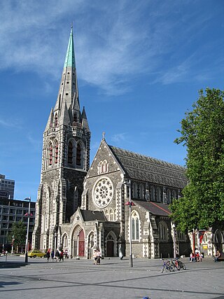
Cathedral Square, locally known simply as the Square, is the geographical centre and heart of Christchurch, New Zealand, where the city's Anglican cathedral, ChristChurch Cathedral is located. The square stands at the theoretical crossing of the city's two main orthogonal streets, Colombo Street and Worcester Street, though in practice both have been either blocked off or detoured around the square itself. The square was badly damaged in the February 2011 Christchurch earthquake.

Christ Church Cathedral, also called ChristChurch Cathedral and (rarely) Cathedral Church of Christ, is a deconsecrated Anglican cathedral in the central city of Christchurch, New Zealand. It was built between 1864 and 1904 in the centre of the city, surrounded by Cathedral Square. It became the cathedral seat of the Bishop of Christchurch, who is in the New Zealand tikanga of the Anglican Church in Aotearoa, New Zealand and Polynesia.

TheArts Centre Te Matatiki Toi Ora is a hub for arts, culture, education, creativity and entrepreneurship in Christchurch, New Zealand. It is located in the Gothic Revival former Canterbury College, Christchurch Boys' High School and Christchurch Girls' High School buildings, many of which were designed by Benjamin Mountfort. The centre is a national landmark and taonga as it is home to New Zealand's largest collection of category one heritage buildings with 21 of the 23 buildings covered by Heritage New Zealand listings.

Rolleston is the seat and largest town in the Selwyn District, in the Canterbury region of New Zealand's South Island. It is located on the Canterbury Plains 22 kilometres (14 mi) south-west of Christchurch, and is part of the wider Christchurch metropolitan area.

The Avon River / Ōtākaro, sometimes rendered as the River Avon, flows through the centre of the city of Christchurch, New Zealand, and into the Pacific Ocean via the Avon Heathcote Estuary / Ihutai, which it shares with the Ōpāwaho / Heathcote River.

Christchurch Central City or Christchurch City Centre is the geographical centre and the heart of Christchurch, New Zealand. It is defined as the area within the Four Avenues and thus includes the densely built up central city, some less dense surrounding areas of residential, educational and industrial usage, and green space including Hagley Park, the Christchurch Botanic Gardens and the Barbadoes Street Cemetery.

The Canterbury Earthquake Recovery Authority was the public service department of New Zealand charged with coordinating the rebuild of Christchurch and the surrounding areas following the 22 February 2011 earthquake. After it was disestablished on 18 April 2016, CERA's functions were taken over by a variety of other agencies.

City Mall is the main pedestrian mall in the central city of Christchurch, New Zealand, comprising two sections of Cashel Street plus the Bridge of Remembrance and one section of High Street. It is also known colloquially as Cashel Mall. The Bridge of Remembrance was pedestrianised in 1976. The main mall was closed to traffic on 11 January 1982 and formally reopened as a pedestrian mall on 7 August, but it was not until 1992 that the entire mall was paved. The mall was redeveloped between 2006 and 2009, and track was installed for an expansion of the heritage tram network.

Victoria Square is a public park located in central Christchurch, New Zealand. Originally known by European settlers as Market Place or Market Square, it was renamed to Victoria Square in 1903 in honour of Queen Victoria. It was one of the four squares included in the original plan of Christchurch when the city was laid out in 1850.

The Crowne Plaza Christchurch, formerly known as the Forsyth Barr Building, is located on the south-east corner of the Armagh and Colombo Streets intersection in Christchurch, New Zealand. Originally owned by Bob Jones and branded Robert Jones House by him, it was commonly referred to as Bob Jones Tower, but some called it Bob's Folly. In the 2011 Christchurch earthquake, its staircases collapsed, trapping the occupants. The building reopened in July 2017 as the city's Crowne Plaza hotel.

The Canterbury Public Library building, was a library in Central Christchurch and the main library of Christchurch City Libraries, New Zealand. It was the largest library in the South Island and the third-biggest in New Zealand. It was also known as the Central Library. It opened in 1982 on the corner of Oxford Terrace and Gloucester Street but was closed on the day of the 22 February 2011 Christchurch earthquake. After the earthquake temporary libraries to serve the Central City were set up at South City Mall, Tuam Street, Manchester Street and Peterborough Street. The building was demolished in 2014 to make way for the Convention Centre Precinct. Tūranga, the replacement library, and Civic Space was opened in 2018.

The Canterbury Earthquake National Memorial is the Crown's official memorial for those killed or seriously injured in the 22 February 2011 Christchurch earthquake. It is located on both sides of the Avon River downstream from the Montreal Street bridge. The memorial opened on 22 February 2017, the sixth anniversary of the earthquake.
A residential red zone is any of several areas of land in and around Christchurch, New Zealand, that experienced severe damage in the 2010 and 2011 Christchurch earthquakes and were deemed infeasible to rebuild on. Through voluntary buyouts, the Crown acquired and demolished or removed over 8,000 properties. The majority were located in a broad swath of the eastern suburbs along the Avon River / Ōtākaro that had suffered damage from soil liquefaction.

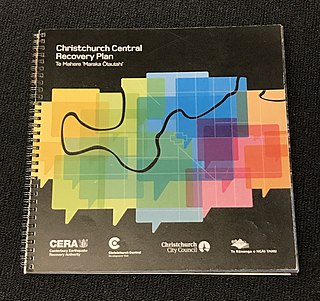
The Christchurch Central Recovery Plan, often referred to as the Blueprint, is the plan developed by the Fifth National Government of New Zealand for the recovery of the Christchurch Central City from a series of earthquakes, in particular the February 2011 Christchurch earthquake. The Canterbury Earthquake Response and Recovery Act 2010 required the Christchurch City Council to develop a recovery plan for the central city. The plan, known as Share an Idea, was presented to the Minister for Canterbury Earthquake Recovery, Gerry Brownlee, in December 2011. Brownlee rejected the city council's plan, established the Canterbury Earthquake Recovery Authority (CERA), and tasked that organisation with developing a plan based on the city council's draft. The Christchurch Central Recovery Plan was published in July 2012 and defined 17 anchor projects. All projects where a timeline was specified were to have been finished by 2017; none of the 17 projects have been delivered on time and some have not even been started yet.

The Christchurch Bus Interchange is the bus station in the Christchurch Central City in New Zealand. Built as one of the 17 anchor projects identified in the Christchurch Central Recovery Plan, it opened in May 2015 after the previous Bus Exchange had been damaged in the 2011 Christchurch earthquake.
The Cathedral of the Blessed Sacrament is the planned successor of Christchurch's former Catholic cathedral which was damaged in the 2010 and 2011 Canterbury earthquakes and later demolished in 2020. This makes the cathedral the future mother church of the Roman Catholic Diocese of Christchurch. Initially, the cathedral was to be located on the corner of Armagh and Colombo Streets, opposite Victoria Square. However, on 21 April 2024, Bishop Michael Gielen announced the cathedral would be returning to the Barbadoes Street site, formerly occupied by the Cathedral of the Blessed Sacrament.

Gloucester Street is a major urban street in central Christchurch in the South Island of New Zealand. It runs for approximately 4.9 kilometres (3.0 mi) from a junction with Rolleston Avenue at its western end, directly opposite Christ's College, to the suburbs of Linwood and Avonside in the east. For the majority of its length it runs due west-east, with the section from the central city's eastern edge to Linwood veering to the northeast.

Club Tower is a contemporary tower in the centre of Christchurch, New Zealand. Built in the late 2000s, it was the first building in Christchurch to receive a 5-star rating under the voluntary Green Star sustainability system, and was the first A-grade commercial building completed in the city since 1989. It received a national sustainability award in 2009 by Architectural Designers New Zealand.


