
Cathedral Square, locally known simply as the Square, is the geographical centre and heart of Christchurch, New Zealand, where the city's Anglican cathedral, ChristChurch Cathedral is located. The square stands at the theoretical crossing of the city's two main orthogonal streets, Colombo Street and Worcester Street, though in practice both have been either blocked off or detoured around the square itself. The square was badly damaged in the February 2011 Christchurch earthquake.
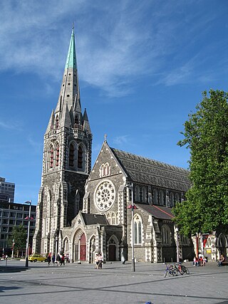
ChristChurch Cathedral, also called Christ Church Cathedral and (rarely) Cathedral Church of Christ, is a deconsecrated Anglican cathedral in the city of Christchurch, New Zealand. It was built between 1864 and 1904 in the centre of the city, surrounded by Cathedral Square. It became the cathedral seat of the Bishop of Christchurch, who is in the New Zealand tikanga of the Anglican Church in Aotearoa, New Zealand and Polynesia.
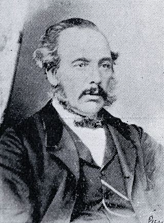
Isaac Luck was a New Zealand architect. A professional builder, he arrived in Lyttelton on the Steadfast in 1851. He was the third chairman of the Christchurch Town Council. He was the brother-in-law of and in partnership with Benjamin Mountfort, and was the less well-known architectural partner for the design of the Canterbury Provincial Council Buildings.

The Christchurch Town Hall, since 2007 formally known as the Christchurch Town Hall of the Performing Arts, opened in 1972, is Christchurch, New Zealand's premier performing arts centre. It is located in the central city on the banks of the Avon River overlooking Victoria Square, opposite the former location of the demolished Christchurch Convention Centre. Due to significant damage sustained during the February 2011 Christchurch earthquake, it was closed until 2019. Council staff initially recommended demolition of all but the main auditorium, but at a meeting in November 2012, councillors voted to rebuild the entire hall. In 2020, the town hall was registered as a Category I heritage building.

The Canterbury Provincial Council Buildings were the buildings of the Canterbury Provincial Council that administered the Canterbury Province from 1853 until the abolition of provincial government in 1876. The buildings are the only purpose-built provincial government buildings in New Zealand still in existence. The buildings were substantially damaged in the February 2011 Christchurch earthquake, and partially demolished by the Christchurch City Council.

Christchurch Central City or Christchurch City Centre is the geographical centre and the heart of Christchurch, New Zealand. It is defined as the area within the Four Avenues and thus includes the densely built up central city, some less dense surrounding areas of residential, educational and industrial usage, and green space including Hagley Park, the Christchurch Botanic Gardens and the Barbadoes Street Cemetery.

Colombo Street is a main road of the city of Christchurch, New Zealand. It runs south-north through the centre of Christchurch with a break at Cathedral Square. As with many other central Christchurch streets, it is named for a colonial Anglican bishopric, Colombo, Sri Lanka in what at the time was known as Ceylon. Parts of the street which run through Sydenham were known as Addison Street during the 1880s, and some parts were known as Colombo Road.
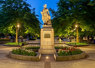
The Cook Statue in Victoria Square, Christchurch, commemorates the three journeys of James Cook to New Zealand. The statue, sculpted by William Trethewey, was unveiled on 10 August 1932 by the Governor-General, Lord Bledisloe. It was donated by bookmaker and philanthropist Matthew Barnett (1861–1935).

Victoria Square is a public park located in central Christchurch, New Zealand. Originally known by European settlers as Market Place or Market Square, it was renamed to Victoria Square in 1903 in honour of Queen Victoria. It was one of the four squares included in the original plan of Christchurch when the city was laid out in 1850.

Victoria Street is a road in the central city of Christchurch, New Zealand. It runs from the intersection of Papanui Road and Bealey Avenue in the north-west, and terminates in the south-east at the corner of Kilmore and Durham Streets. One of the two diagonal roads that break the original grid plan, it was very important in the development of Christchurch.

The Crowne Plaza Christchurch, formerly known as the Forsyth Barr Building, is located on the south-east corner of the Armagh and Colombo Streets intersection in Christchurch, New Zealand. Originally owned by Bob Jones and branded Robert Jones House by him, it was commonly referred to as Bob Jones Tower, but some called it Bob's Folly. In the 2011 Christchurch earthquake, its staircases collapsed, trapping the occupants. The building reopened in July 2017 as the city's Crowne Plaza hotel.

The Canterbury Public Library building, was a library in Central Christchurch and the main library of Christchurch City Libraries, New Zealand. It was the largest library in the South Island and the third-biggest in New Zealand. It was also known as the Central Library. It opened in 1982 on the corner of Oxford Terrace and Gloucester Street but was closed on the day of the 22 February 2011 Christchurch earthquake. After the earthquake temporary libraries to serve the Cental City were set up at South City Mall, Tuam Street, Manchester Street and Peterborough Street. The building was demolished in 2014 to make way for the Convention Centre Precinct. Tūranga, the replacement library, and Civic Space was opened in 2018.

Victoria Mansions is a residential Category II heritage building in central Christchurch, New Zealand.
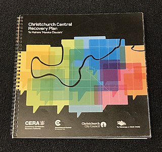
The Christchurch Central Recovery Plan, often referred to as the Blueprint, is the plan developed by the Fifth National Government of New Zealand for the recovery of the Christchurch Central City from a series of earthquakes, in particular the February 2011 Christchurch earthquake. The Canterbury Earthquake Response and Recovery Act 2010 required the Christchurch City Council to develop a recovery plan for the central city. The plan, known as Share an Idea, was presented to the Minister for Canterbury Earthquake Recovery, Gerry Brownlee, in December 2011. Brownlee rejected the city council's plan, established the Canterbury Earthquake Recovery Authority (CERA), and tasked that organisation with developing a plan based on the city council's draft. The Christchurch Central Recovery Plan was published in July 2012 and defined 17 anchor projects. All projects where a timeline was specified were to have been finished by 2017; none of the 17 projects have been delivered on time and some have not even been started yet.
The Christchurch Catholic Cathedral is the planned replacement to the Cathedral of the Blessed Sacrament which was damaged in the 2010 and 2011 Canterbury earthquakes and later demolished in 2020. This makes the cathedral the future mother church of the Roman Catholic Diocese of Christchurch. Initially, the cathedral was to be located on the corner of Armagh and Colombo Streets, opposite Victoria Square. However, on 21 April 2024, Bishop Michael Gielen announced the cathedral would be returning to the Barbados Street site, formerly occupied by the Cathedral of the Blessed Sacrament.
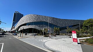
Te Pae Christchurch Convention Centre is a convention centre located in Christchurch Central City, New Zealand. The centre is a replacement for the previous Christchurch Convention Centre that was demolished after the 2011 Christchurch earthquake. Originally known as the Convention Centre Precinct, construction was funded by the New Zealand Government as part of the Christchurch Central Recovery Plan. The centre is owned by the Crown through Rau Paenga Crown Infrastructure Delivery Ltd state-owned enterprise, and managed by ASM Global. The polysemous name Te Pae is "inspired" by the Māori language, and can roughly be interpreted to mean "gathering place".

Gloucester Street is a major urban street in central Christchurch in the South Island of New Zealand. It runs for approximately 4.9 kilometres (3.0 mi) from a junction with Rolleston Avenue at its western end, directly opposite Christ's College, to the suburbs of Linwood and Avonside in the east. For the majority of its length it runs due west-east, with the section from the central city's eastern edge to Linwood veering to the northeast.
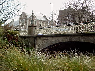
The Armagh Street Bridge is a historic bridge on Armagh Street in Christchurch Central City. It sits between the Convention Centre Precinct and the Magistrate's Court at the south-west corner of Victoria Square. Its initial importance was it making a connection to the Canterbury Provincial Council Buildings just beyond the Magistrate's Court.
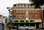 Frontage of Isaac House on Armagh Street in 2010, before the 2011 Christchurch earthquake.
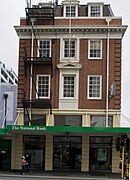 Frontage on Colombo Street in 2010.
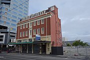 Isaac House in 2015, with the surrounding buildings demolished.
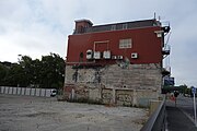 The back of the building before the construction of the surrounding Convention Centre Precinct.


