Wharetiki House

Last updated

Wharetiki House
Wharetiki 71.jpg
Wharetiki House in March 2011
Wharetiki House
General information
TypeResidential, converted to a pre-school
Location Christchurch Central City
Address854 Colombo Street
Town or cityChristchurch
CountryNew Zealand
Coordinates 43°31′26″S172°38′13″E / 43.52402°S 172.63697°E / -43.52402; 172.63697
Completed1904
Demolished21 July 2011
Client Matthew Barnett
OwnerDavid Hampton
Technical details
Floor counttwo
Official nameWharetiki
Designated25 June 2004
Reference no.7551
References
"Wharetiki". Register of Historic Places. Heritage New Zealand . Retrieved 27 July 2011.

Wharetiki, for some time known as Glenfell House, was an Edwardian timber dwelling in Colombo Street, Christchurch in New Zealand. Built in 1904 for businessman and philanthropist Matthew Barnett, it was damaged in the February 2011 Christchurch earthquake. After the Canterbury Earthquake Recovery Authority ordered the demolition of the Category II heritage building registered by Heritage New Zealand, it was the first court challenge of CERA's post-earthquake powers. In July 2011, the High Court decided in the authority's favour and the building was demolished the following day.

Contents

History

Matthew Frank Barnett (1859–1935) was a successful bookmaker from Christchurch. He ran his betting business with his friend Peter Grant. [1]

Wharetiki House in May 2011 Wharetiki in May 2011.jpg
Wharetiki House in May 2011

In July 1901, Barnett bought two adjoining parcels of land (Lot 3 & 4, Deposited Plan 1147) from Henry Layton Bowker. The overall property was roughly square and fronted onto Colombo and Salisbury Streets, a location in the north of the Christchurch Central City. [2] According to records held by the valuation department, construction of the house started in 1902. The house was built on Lot 3 of the property (the northern section), and Lot 4, facing Salisbury Street, had a garage and a bowling green. [2] Construction was completed in 1904. [1] The house was connected to the city drains in April 1904, but it was not until 1923 that electricity was supplied to the building. Water came initially from an artesian well on the property. [2]

It is not known with certainty who the architect was, but evidence points towards Robert England (1863–1908). At the time, architectural pattern books were common, but the Wharetiki design has not been found. England, on the other hand, has designed houses of similar style, most importantly for Barnett's friend and business partner Grant, who in about 1906 had Westhaven Eventide Home built at 901 Colombo Street, i.e. in the immediate neighbourhood. [1] Closer to Art Nouveau in style than the Arts and Craft style of Wharetiki, it nevertheless had the same style turret incorporated into the design. [2]

The Barnett family - standing from left: Tui, Olly, Ethel - sitting from left: Alice May (Topsy), Ivy, Mary (nee Whelan), Matthew, Kate Matthew Barnett and Family.jpg
The Barnett family – standing from left: Tui, Olly, Ethel – sitting from left: Alice May (Topsy), Ivy, Mary (née Whelan), Matthew, Kate

Wharetiki was a large and representative dwelling, displaying the wealth of its owner. [1] Barnett was married to Mary (née Whelan) and they had six children, born between 1889 and 1903. [3] The house had several servants and Mary Barnett's unmarried younger sister Maria (known as Polly) was in charge of them. [4] The house had a total floor area of 408 square metres (4,390 sq ft), which made for comfortable living. [2]

Mary Barnett's father died in 1908 and her mother Margaret, together with her second youngest son Bill, moved to Christchurch to live at Wharetiki, too. Margaret Whelan lived there for the rest of her life and she died at Wharetiki in 1926. [5] Mary Barnett fell ill in 1930 and was confined to a wheel chair. The back stairs of Wharetiki House were replaced with a lift at that stage, so that she could move around the house. Mary Barnett died on 1 March 1931 at Wharetiki, aged 66. [3] Matthew Barnett died on 28 January 1935, aged 75, also at Wharetiki. He was buried next to his wife the following day. [1]

Other owners

After Barnett's death, the house was inherited by three family members: his brother Arthur, his oldest son Olly Barnett, and his wife's sister Maria (Polly) Whelan. They immediately employed auctioneer H. G. Livinstone & Co to sell the property and all furnishings, with the date for auction set as 14 May 1935. [2] It was sold to the widow Margaret Isabella Marshall, who appears not to have lived in the building herself. She onsold the house in 1942 to Ernest Archbold, who in turn sold the building to Robert Heaton Livingstone in the following year. [1] [2]

Probably under Archbold's ownership, the house was used by the Glenfell sisters (Jean, Reynolda and Ellen) as a boarding house for pupils from Christchurch Girls' High School, who at the time used a building later known as the Cranmer Centre as their school. The connection with the girls school lasted for four years. The building became known as Glenfell House during that time. The ownership of the property kept changing. From Livinstone, the property passed to the Public Trustee in 1957, who onsold to the Staffordshire Finance Company in 1964. It is likely that at that point, the Glenfell connection with the house finished. [1] [2]

The house change owners again in 1973, when Peter John Diver and David Stephen Diver took over. They sold the property to Sunset Properties. The owner of that company (Mr Merrett) was a son of the owner of the Staffordshire Finance Company. There was a brief period in the 1980s when the house was operated as Grenville Guesthouse, but for the remaining time, it was a boarding house. [1] [2]

In 1995, the property was purchased by Chesterfield Preschools Ltd, who operated a pre-school on the ground floor. [1] The owner of that company is David Hampton, [2] who is still the current owner of the property. [6]

Wharetiki house in 2006 Wharetiki House in 2006.jpg
Wharetiki house in 2006

2010 and 2011 earthquakes

Wharetiki after demolition, with only the turret sitting in the garden Wharetiki 93.jpg
Wharetiki after demolition, with only the turret sitting in the garden

The building suffered some damage in the 2010 Canterbury earthquake, and severe damage in the February 2011 Christchurch earthquake. According to the owner, it was not further damaged in the June 2011 Christchurch earthquake. The Canterbury Earthquake Recovery Authority (CERA) assessed the building several times and eventually ordered its demolition, [6] with the building included on the demolition list in early April. [7] The demolition order was challenged by the owner, who took the case to the High Court. It was the first time that CERA's power to order the demolition of a building had been challenged in the courts. Justice Whata dismissed the challenge on 20 June 2011, and the building was demolished the following day. [6]

Heritage registration

Wharetiki House was registered by the New Zealand Historic Places Trust as a Category II heritage building on 25 June 2004 with registration number 7551. [1]

Related Research Articles

<span class="mw-page-title-main">Isaac Luck</span>

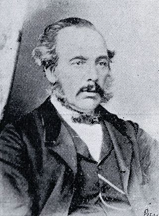
Isaac Luck was a New Zealand architect. A professional builder, he arrived in Lyttelton on the Steadfast in 1851. He was the third chairman of the Christchurch Town Council. He was the brother-in-law of and in partnership with Benjamin Mountfort, and was the less well-known architectural partner for the design of the Canterbury Provincial Council Buildings.

<span class="mw-page-title-main">Cathedral of the Blessed Sacrament, Christchurch</span> Church in Christchurch Central City, New Zealand

The Cathedral of the Blessed Sacrament was a Catholic cathedral located in the city centre of Christchurch, New Zealand. It was the mother church of the Roman Catholic Diocese of Christchurch and seat of the Bishop of Christchurch.

<span class="mw-page-title-main">Manchester Courts</span> Commercial high-rise in Corner Hereford and Manchester Sts, Christchurch Central City

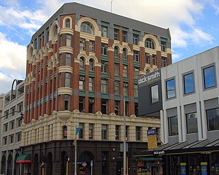
Manchester Courts, earlier known as the MLC Building, was a commercial high-rise building in the Christchurch Central City. Built in 1905–1906 for the New Zealand Express Company, it was at the time the tallest commercial building in Christchurch. A Category I heritage building, it suffered serious structural damage in the 2010 Canterbury earthquake and was condemned to be demolished. Demolition began on 19 October, and was completed in February 2011.

<span class="mw-page-title-main">Colombo Street</span>

Colombo Street is a main road of the city of Christchurch, New Zealand. It runs south-north through the centre of Christchurch with a break at Cathedral Square. As with many other central Christchurch streets, it is named for a colonial Anglican bishopric, Colombo, Sri Lanka in what at the time was known as Ceylon. Parts of the street which run through Sydenham were known as Addison Street during the 1880s, and some parts were known as Colombo Road.

<span class="mw-page-title-main">Sydenham Heritage Church</span> Church in New Zealand, New Zealand

Sydenham Heritage Church, originally known as the Colombo Street Methodist Church or Colombo Street Wesleyan Church or Colombo Road Wesleyan Church was a heritage-listed stone church building located in Sydenham, an inner suburb Christchurch, New Zealand. It was registered as an "Historic Place – Category II " by the New Zealand Historic Places Trust.

<span class="mw-page-title-main">Church of the Good Shepherd, Christchurch</span> Church in Christchurch, New Zealand

The Church of the Good Shepherd in Phillipstown, Christchurch, New Zealand was the oldest and last surviving brick church designed by architect Benjamin Mountfort (1825–1898). It was registered as a "Historic Place – Category I" by the New Zealand Historic Places Trust.

<span class="mw-page-title-main">Canterbury Earthquake Recovery Authority</span>

The Canterbury Earthquake Recovery Authority was the public service department of New Zealand charged with coordinating the rebuild of Christchurch and the surrounding areas following the 22 February 2011 earthquake. After it was disestablished on 18 April 2016, CERA's functions were taken over by a variety of other agencies.

<span class="mw-page-title-main">Matthew Barnett (bookmaker)</span>

Matthew Frank Barnett, also known as Mat Barnett, was a bookmaker and philanthropist from Christchurch, New Zealand. In his retirement, he became well known in lawn bowls. He donated the statue of James Cook in Victoria Square to the city. His family dwelling, Wharetiki House, was a prominent landmark on Colombo Street in the Christchurch Central City until its demolition in July 2011, following a demolition order by the Canterbury Earthquake Recovery Authority.

<span class="mw-page-title-main">Statue of James Cook, Christchurch</span>

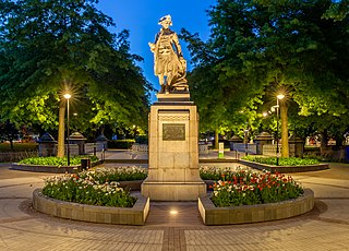
The Cook Statue in Victoria Square, Christchurch, commemorates the three journeys of James Cook to New Zealand. The statue, sculpted by William Trethewey, was unveiled on 10 August 1932 by the Governor-General, Lord Bledisloe. It was donated by bookmaker and philanthropist Matthew Barnett (1861–1935).

<span class="mw-page-title-main">City Mall, Christchurch</span>

City Mall is the main pedestrian mall in the central city of Christchurch, New Zealand, comprising two sections of Cashel Street plus the Bridge of Remembrance and one section of High Street. It is also known colloquially as Cashel Mall. The Bridge of Remembrance was pedestrianised in 1976. The main mall was closed to traffic on 11 January 1982 and formally reopened as a pedestrian mall on 7 August, but it was not until 1992 that the entire mall was paved. The mall was redeveloped between 2006 and 2009, and track was installed for an expansion of the heritage tram network.

<span class="mw-page-title-main">Implosion of Radio Network House</span> Building demolition in New Zealand

The implosion of Radio Network House in 2012 was the first implosion used in New Zealand to demolish a building, and was a "test case" for the potential to use such a demolition method on similar buildings in Christchurch Central City that had been damaged in the 2011 earthquake. Like most other large buildings in central Christchurch, Radio Network House was damaged beyond repair in the 2011 earthquake, and the Canterbury Earthquake Recovery Authority (CERA) added it to the demolition list in August 2011. In July 2012, it was announced that the building was going to be imploded, involving a specialist company from the United States with considerable experience in this type of work.

<span class="mw-page-title-main">Central City Red Zone</span>

The Central City Red Zone, also known as the CBD Red Zone, was a public exclusion zone in the Christchurch Central City implemented after the 22 February 2011 Christchurch earthquake. After February 2013, it was officially renamed the CBD Rebuild Zone by government agencies, but remained known as the Red Zone. It gradually shrank in size and the last cordons were removed on 30 June 2013, 859 days after the earthquake.

<span class="mw-page-title-main">McLean's Mansion</span> Homestead in Christchurch, New Zealand

McLean's Mansion is a homestead in Christchurch, New Zealand. The two hectares property is situated between Manchester and Colombo Streets. The mansion was initially known as 'Holly Lea', but later became known as McLean's Mansion after its initial owner. It was the largest wooden residence in New Zealand. The mansion, designed by Robert England, architect of Christchurch, is a fusion of styles of Jacobean architecture and Victorian features, akin to the Mentmore Towers (1852–54) of Sir Joseph Paxton in Buckinghamshire in England. It was built between April 1899 and September 1900. The house is registered as a Category I heritage building by Heritage New Zealand. After the 2011 Christchurch earthquake, the owners applied to demolish the earthquake-damaged buildings, but their request was denied by the heritage body and the courts. In December 2016, the building sold to a trust that will restore it for use as a gallery. Restoration is expected to be finished by 2024.

<span class="mw-page-title-main">Forsyth Barr Building</span> Office high rise in Christchurch Central City

The Crowne Plaza Christchurch, formerly known as the Forsyth Barr Building, is located on the south-east corner of the Armagh and Colombo Streets intersection in Christchurch, New Zealand. Originally owned by Bob Jones and branded Robert Jones House by him, it was commonly referred to as Bob Jones Tower, but some called it Bob's Folly. In the 2011 Christchurch earthquake, its staircases collapsed, trapping the occupants. The building reopened in July 2017 as the city's Crowne Plaza hotel.

<span class="mw-page-title-main">Tūranga</span> Library in Christchurch Central City

Tūranga is the main public library in Christchurch, New Zealand. It opened on 12 October 2018 and replaced the nearby Christchurch Central Library that was closed on the day of the 2011 Christchurch earthquake.
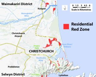
<span class="mw-page-title-main">Residential red zone</span>

The residential red zone refers to areas of land in and around Christchurch, New Zealand, that experienced severe damage in the 2010 and 2011 Christchurch earthquakes and were deemed infeasible to rebuild on. Through voluntary buyouts, the Crown acquired and demolished or removed over 8,000 properties. The majority were located in a broad swath of the eastern suburbs along the Avon River / Ōtākaro that had suffered damage from soil liquefaction.

<span class="mw-page-title-main">Christchurch Central Recovery Plan</span> Plan for rebuilding Christchurch after the 2011 earthquake

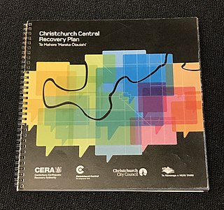
The Christchurch Central Recovery Plan, often referred to as the Blueprint, is the plan developed by the Fifth National Government of New Zealand for the recovery of the Christchurch Central City from a series of earthquakes, in particular the February 2011 Christchurch earthquake. The Canterbury Earthquake Response and Recovery Act 2010 required the Christchurch City Council to develop a recovery plan for the central city. The plan, known as Share an Idea, was presented to the Minister for Canterbury Earthquake Recovery, Gerry Brownlee, in December 2011. Brownlee rejected the city council's plan, established the Canterbury Earthquake Recovery Authority (CERA), and tasked that organisation with developing a plan based on the city council's draft. The Christchurch Central Recovery Plan was published in July 2012 and defined 17 anchor projects. All projects where a timeline was specified were to have been finished by 2017; none of the 17 projects have been delivered on time and some have not even been started yet.

<span class="mw-page-title-main">Bus Interchange</span> Bus station in Christchurch

The Bus Interchange is the bus station in the Christchurch Central City in New Zealand. Built as one of the 17 anchor projects identified in the Christchurch Central Recovery Plan, it opened in May 2015 after the previous Bus Exchange had been damaged in the 2011 Christchurch earthquake.

References

  1. 1 2 3 4 5 6 7 8 9 10 "Wharetiki". Register of Historic Places. Heritage New Zealand . Retrieved 27 July 2011.
  2. 1 2 3 4 5 6 7 8 9 10 Hore, Glynis (1995), Grenfell House : 854 Colombo Street, Christchurch, Christchurch: G. Hore, pp. 1–41
  3. 1 2 Stott, Margaret R. "Mary Bridget Whelan b.1864" . Retrieved 27 July 2011.
  4. Stott, Margaret R. "Maria Whelan (Poll) b.1867". Archived from the original on 28 March 2012. Retrieved 27 July 2011.
  5. Stott, Margaret R. "James Whelan b.1836". Archived from the original on 28 March 2012. Retrieved 30 July 2011.
  6. 1 2 3 Heather, Ben (27 July 2011). "Bid to save historic house fails". The Press. p. A12. Retrieved 27 July 2011.
  7. "Buildings set for demolition, partial demolition or make safe". Environment Canterbury and Christchurch City Council. Retrieved 4 August 2011.