New Regent Street

Last updated

New Regent Street
New Regent Street In Spring.jpg
Looking North along New Regent Street in 2023
Location map New Zealand Christchurch.png
Red pog.svg
Location within the Christchurch Central City
General information
TypeTerrace shops
Architectural style Spanish Mission architecture
Location Christchurch Central City
AddressNew Regent Street
Town or cityChristchurch
CountryNew Zealand
Coordinates 43°31′45.35″S172°38′19.39″E / 43.5292639°S 172.6387194°E / -43.5292639; 172.6387194
Elevation9 m
Current tenants40 buildings individually tenanted
Construction started1931
Completed1 April 1932
Renovated2012/13
ClientArthur Francis Stacey (1888–1952) for Regent Street Ltd
Owner40 buildings individually owned
Technical details
Floor counttwo
Design and construction
Architect(s) Francis Willis
Main contractorP. Graham and Son, Limited
Designated28 June 1990
Reference no.4385
References
"New Regent Street Terrace Shops". New Zealand Heritage List/Rārangi Kōrero. Heritage New Zealand . Retrieved 27 February 2016.

New Regent Street is a pedestrian mall in Christchurch. Built as a private development in the early 1930s with 40 shops in Spanish Mission architectural style, it is one of the city's major tourist attractions. Providing a number of small shops as a comprehensive development was an advanced idea at the time, and New Regent Street is regarded as a forerunner to modern shopping malls. Due to its coherent architectural character, the buildings in the streets are listed as Category I heritage items by Heritage New Zealand, and in addition, the entire street has a historic area listing. The street was pedestrianised in 1994 in preparation for the introduction of the Christchurch heritage tram, which began operation in February 1995. Damaged in the February 2011 Christchurch earthquake, the street and buildings reopened in April 2013, and the tram returned from November of that year. Following the 2016 Valentine's Day earthquake, five of the buildings that had not been repaired after the previous earthquakes have been cordoned off, which stopped the tram from operating on its original heritage loop until May.

Contents

Background and location

New Regent Street is located in the Christchurch Central City. It is oriented in a north-south direction and placed between Armagh Street at its north end, and Gloucester Street on its south side. Cathedral Square, the centre of Christchurch, is located one block over to the south-west. What is now New Regent Street was originally known as "The Circus paddock", as visiting circuses would make use of the land. [1] From 1888, the land was occupied by a building called the Colosseum. The Colosseum was initially an ice skating rink, then used for a boot factory, became a taxi rank for some time and in 1908, it was Christchurch's first movie theatre. [2] The Colosseum was demolished in January 1931. [3] [4] [5]

History

Development

Arthur Stacey, the driving force behind the creation of New Regent Street Stacey-001.jpg
Arthur Stacey, the driving force behind the creation of New Regent Street
Francis Willis, the architect for New Regent Street Francis Willis (architect), ca 1950s.jpg
Francis Willis, the architect for New Regent Street

In 1929, businessman and chairman of The Press , George Gould, proposed a variety of measures to relieve traffic congestion in Colombo Street and Cathedral Square, including a new bridge over the Avon River connecting Oxford Terrace with Durham Street south, and a new diagonal street from the Armagh Street / Manchester Street intersection to Gloucester Street near its intersection with Colombo Street. The latter proposal would have required the demolition of the Colosseum. Gould suggested this diagonal street be called Little High Street, in reference to the diagonal High Street further south in the central city. [6] Only two weeks after Gould's proposal, a group of businessman led by Arthur Francis Stacey put a proposal for a new street with a Spanish theme to Christchurch City Council's town planning committee. The group had secured options on the Colosseum and on those two properties that separated the Colosseum from access onto Armagh Street. [7] [8] The plans had been drawn by Francis Willis, who had previously been employed by Christchurch City Council as their architect, but who had since 1924 been self-employed. [3] [7] Stacey and his business partners had formed a company called Regent Street Limited in 1929; [2] other company directors were David Manson, Alexander Hamilton Forbes, and John Joseph Dougall. [9] By February 1930, the project had been approved in principle by Christchurch City Council. [10] The concept of a number of small shops all built as a comprehensive development was advanced for its time, and can be regarded as the forerunner of modern shopping malls. [11]

New Regent Street during the Matariki celebrations (June 2021) New Regent Street 27.jpg
New Regent Street during the Matariki celebrations (June 2021)

A building permit for the construction of the buildings was imminent, but had not been issued by January 1931, while the demolition of the Colosseum was carried out. [12] The contract for the construction of the 40 buildings and the roadway was let to the Boyle Brothers for NZ£32,000. [13] The builder did not perform and the contract was retendered for approximately NZ£32,000, with P. Graham and Son, Limited, as the successful party. [14] [9] The overall cost of the project was NZ£90,000. [14] [15] The street was built at a width of 40 feet (12 m), and the north-south length of Christchurch Central City blocks is 330 feet (100 m). [15] The sculptor William Trethewey carried out some of the interior decorations. [15]

The company asked for the street to be named Regent Street, but the Christchurch City Council declined the request on the grounds that a street of that name already existed in Sydenham, and suggested New Regent Street instead. [16] Regent Street in Sydenham was renamed Roxburgh Street in 1948. [17] New Regent Street is named for London's Regent Street, itself that city's first planned street, and built between 1814 and 1825. [1]

The street was finished in late March 1932. One of its features was a lighting system consisting of 400 lamps, and when this was first switch on for a trial on 24 March, hundreds of citizens went for a walk down the 100 metres (330 ft) long street. [18] To make use of the lighting, the formal opening was held on the evening of 1 April 1932. [14] The proceedings were chaired by Dan Sullivan, the Mayor of Christchurch, who also gave the first speech. Other speakers were David Manson (chairman of Regent Street Ltd), city councillor A. H. Andrews (chairman of the town planning committee), and Stacey. Mrs. Manson then cut the ribbon. [15] During the opening speech of the mayor, the crowd was entertained by a person from the crowd warning of a man with a sword, reference to the de Groot incident that happened at the Sydney Harbour Bridge two weeks earlier where a protester cut the ribbon prior to the official ceremony. [19]

The opening happened during the depth of the Great Depression, and it was one of only a few larger projects undertaken in the South Island at the time. [20] [11] Whilst Manson claimed in his speech at the opening that half the shops had been let, [15] only three shops were actually occupied. [20] Later in 1932, the contractor, P. Graham and Son, took two of the directors (Manson and Forbes) to court over outstanding payments of NZ£1,000. [9] The contractor won the case and was awarded costs. [21] [22]

Problems with parking for extended periods of time occurred and in April 1933, parking of cars in New Regent Street was time-restricted to 20 minutes. [23] Around the same time, Regent Street Limited was in financial difficulty and petition to wind up the company was filed, and the judge gave the company a fortnight to pay up, which resolved the issue. [24] [25] Regent Street Limited sold off individual shops in the 1940s until all 40 units were in private ownership. [20] [26] The roadway was transferred to Christchurch City Council, making it a public road, after World War II. [20]

Pedestrian mall

New Regent Street forms the north-eastern extent of the original Christchurch heritage tramway circuit Christchurch heritage tramway circuit.png
New Regent Street forms the north-eastern extent of the original Christchurch heritage tramway circuit

In 1986, a one-way restriction was imposed for driving on New Regent Street. [27] This measure was in place for only eight years before the street was closed to automobile traffic in 1994 and turned into a pedestrian mall in preparation for the reintroduction of the Christchurch tram. [27] Originally, it was intended for the tram to go back and forth along Worcester Street, but the plans were changed and a loop created, with Rolleston Avenue, Armagh Street, New Regent Street and the John Britten property known as Cathedral Junction making up the route. The tram began operating on 4 February 1995.

Earthquakes

Two of Thacker's shops that are unrepaired and boarded up Watching and Wondering.jpg
Two of Thacker's shops that are unrepaired and boarded up
Thacker's five properties in New Regent Street were cordoned off after the 2016 Valentine's Day earthquake New Regent Street 008.JPG
Thacker's five properties in New Regent Street were cordoned off after the 2016 Valentine's Day earthquake

The buildings sustained damage during the 22 February 2011 Christchurch earthquake. [27] The whole central city was cordoned off, and the public did not have access. Repairs to the street and buildings were carried out by Naylor Love Construction Limited for NZ$3,000,000, [28] with Fulton Ross Team Architects providing the architectural inputs. [29] New Regent Street was set to be reopened in December 2012, but this was delayed to February 2013, and then March, and it finally did open on Saturday, 20 April 2013. The Press described the opening as an "anti-climax", as only five of the shops were open for business. A further fourteen shops had been tenanted but were not ready, while tenants for seven shops had yet to be found. [30] Five of the buildings, all owned by Helen Thacker, had not been repaired or earthquake strengthened. [30] [31] Two of those buildings were classed as earthquake-prone, and after months of negotiations by Canterbury Earthquake Recovery Authority staff, the owner agreed to have those two buildings earthquake strengthened. This allowed for safety fences to be removed from New Regent Street in December 2013. [32]

The tram began operating again in November 2013 on a limited route from New Regent Street to Worcester Boulevard; the tracks in Armagh Street had to be repaired still. In November 2014, the pre-earthquake loop reopened. [33] Some New Regent Street retailers claim that half their custom comes from tourist arriving there by tram. [34] [31]

Following the 2016 Valentine's Day earthquake, the five properties in New Regent Street owned by Helen Thacker were cordoned off due to risk of collapse of their façades, which stopped the tram from doing its traditional route through the pedestrian mall. [31] Later on, a further two properties not owned by Thacker were cordoned off. [35] The operator of the tramway, Michael Esposito from Welcome Aboard, claimed that the tram had so far brought 100,000 customers to New Regent Street during the 2015/16 summer. [31] Tim Hunter, the chief executive of Christchurch & Canterbury Tourism, lamented that the inaction of one owner "will put us back in the world news as not being visitor friendly." [36] The street's spokesperson stated that business had been "disappointing" while the tram was not operating. [35] The barriers were removed and the tram began operating again on 1 May 2016. [35]

Heritage registrations

The buildings were classified as Category I heritage items by the New Zealand Historic Places Trust (since renamed Heritage New Zealand) on 28 June 1990, with registration number 4385. [20] On 27 October 1994, the New Zealand Historic Places Trust registered the street as a historic area, with registration number 7057. [11] The buildings are listed in the Christchurch District Plan as group 2 heritage buildings. [37]

See also

Related Research Articles

<span class="mw-page-title-main">Christchurch</span> City in Canterbury, New Zealand

Christchurch is the largest city in the South Island of New Zealand and the seat of the Canterbury Region. Christchurch lies on the South Island's east coast, just north of Banks Peninsula on Pegasus Bay. The Avon River (Ōtākaro) flows through the centre of the city, with an urban park along its banks.

<span class="mw-page-title-main">New Brighton, New Zealand</span> Coastal suburb of Christchurch, NZ

New Brighton is a coastal suburb of Christchurch, New Zealand, 8 kilometres (5.0 mi) east of the city centre. It is one of eastern Christchurch's main entertainment and tourist centres, with its architecturally unique pier and scenic coastline. The 2011 Christchurch earthquakes caused significant damage in the area.

<span class="mw-page-title-main">Cathedral Square, Christchurch</span> Square in Christchurch, New Zealand

Cathedral Square, locally known simply as the Square, is the geographical centre and heart of Christchurch, New Zealand, where the city's Anglican cathedral, ChristChurch Cathedral is located. The square stands at the theoretical crossing of the city's two main orthogonal streets, Colombo Street and Worcester Street, though in practice both have been either blocked off or detoured around the square itself. The square was badly damaged in the February 2011 Christchurch earthquake.

<span class="mw-page-title-main">Canterbury Provincial Council Buildings</span> Government administration in Christchurch Central City, Christchurch

The Canterbury Provincial Council Buildings were the buildings of the Canterbury Provincial Council that administered the Canterbury Province from 1853 until the abolition of provincial government in 1876. The buildings are the only purpose-built provincial government buildings in New Zealand still in existence. The buildings were substantially damaged in the February 2011 Christchurch earthquake, and partially demolished by the Christchurch City Council.

<span class="mw-page-title-main">Christchurch Central City</span> Central area of Christchurch, New Zealand

Christchurch Central City or Christchurch City Centre is the geographical centre and the heart of Christchurch, New Zealand. It is defined as the area within the Four Avenues and thus includes the densely built up central city, some less dense surrounding areas of residential, educational and industrial usage, and green space including Hagley Park, the Christchurch Botanic Gardens and the Barbadoes Street Cemetery.

<span class="mw-page-title-main">Charles Hulbert (mayor)</span> New Zealand mayor

Charles Partridge Hulbert was Mayor of Christchurch in from December 1883 to December 1885.

<span class="mw-page-title-main">John Joseph Dougall</span> New Zealand politician

John Joseph Dougall was Mayor of Christchurch in 1911–1912. He was a solicitor by profession. In his later life, the Navy League was his main interest.

<span class="mw-page-title-main">Colombo Street</span> Main road in Christchurch, New Zealand

Colombo Street is a main road of the city of Christchurch, New Zealand. It runs south-north through the centre of Christchurch with a break at Cathedral Square. As with many other central Christchurch streets, it is named for a colonial Anglican bishopric, Colombo, Sri Lanka in what at the time was known as Ceylon. Parts of the street which run through Sydenham were known as Addison Street during the 1880s, and some parts were known as Colombo Road.

<span class="mw-page-title-main">Victoria Clock Tower</span> Historic site in Victoria Street, Christchurch Central City

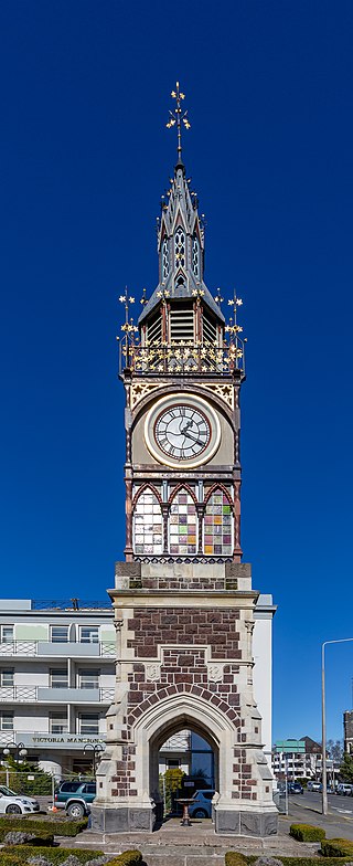
The Victoria Clock Tower, also known as the Diamond Jubilee Clock Tower, is a heritage-registered clock tower located in Christchurch, New Zealand. Designed by Benjamin Mountfort, it is registered as a "Historic Place – Category I" by the New Zealand Historic Places Trust.

<span class="mw-page-title-main">Warner's Hotel</span> Hotel in Christchurch, New Zealand

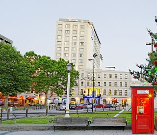
Warner's Hotel in 50 Cathedral Square, Christchurch is the site of a hotel established in 1863. The original building, extended on numerous occasions, burned down in 1900. A new building was built in 1901. Again, it underwent numerous alterations. A fourth storey was added in 1910 and the northern end of the building was demolished in 1917 and a theatre built in its place to create a noise buffer to the printing presses of the adjoining Lyttelton Times Building. The theatre was demolished in 1996 and patrons enjoyed a beer garden. In 2010, a high-rise Novotel hotel opened on the site of the beer garden and in the process, the historical and symmetrical 1901 façade was recreated.

<span class="mw-page-title-main">Cranmer Centre</span> Former school in Christchurch, New Zealand

The Cranmer Centre was a historic building in Christchurch, New Zealand. Its original use, until 1986, was as the Christchurch Girls' High School, the second high school for girls in the country. Registered with the New Zealand Historic Places Trust as a Category I heritage building, it was purchased by Arts Centre of Christchurch Trust in 2001, and demolished in May 2011 following the February 2011 Christchurch earthquake.

<span class="mw-page-title-main">Statue of James Cook, Christchurch</span> Statue in Christchurch, New Zealand

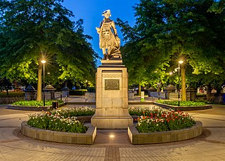
The Cook Statue in Victoria Square, Christchurch, commemorates the three journeys of James Cook to New Zealand. The statue, sculpted by William Trethewey, was unveiled on 10 August 1932 by the Governor-General, Lord Bledisloe. It was donated by bookmaker and philanthropist Matthew Barnett (1861–1935).

<span class="mw-page-title-main">City Mall, Christchurch</span> Street in Christchurch Central City, New Zealand

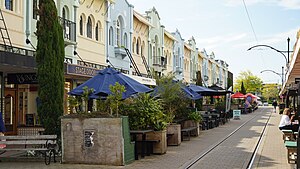
City Mall is the main pedestrian mall in the central city of Christchurch, New Zealand, comprising two sections of Cashel Street plus the Bridge of Remembrance and one section of High Street. It is also known colloquially as Cashel Mall. The Bridge of Remembrance was pedestrianised in 1976. The main mall was closed to traffic on 11 January 1982 and formally reopened as a pedestrian mall on 7 August, but it was not until 1992 that the entire mall was paved. The mall was redeveloped between 2006 and 2009, and track was installed for an expansion of the heritage tram network.

<span class="mw-page-title-main">George Gould (businessman)</span>

George Gould was a New Zealand farmer, businessman, stock breeder, racehorse owner and breeder, and racing administrator. He was born in Christchurch, New Zealand on 6 April 1865. His father (1823–1889), a prominent businessman, had the same name. He was the uncle of George Macdonald. He was the grandfather of British politician, Bryan Gould.

<span class="mw-page-title-main">Victoria Square, Christchurch</span> Public place in Christchurch, New Zealand

Victoria Square is located in central Christchurch, New Zealand. Originally known as Market Place or Market Square, it was the site of market days, fairs, and trade before its redevelopment in 1896–1897 into a park. Subsequent to the February 2011 earthquake, the square was located in the Central City Red Zone and was closed, reopening in November 2012. Its notable landmarks include the Captain James Cook statue, Queen Victoria statue, H. L. Bowker Fountain, and the Victoria Square Poupou. It also features the country's oldest cast iron and stone bridge, now known as the Hamish Hay Bridge.

<span class="mw-page-title-main">Hamish Hay Bridge</span> Bridge in Christchurch, New Zealand

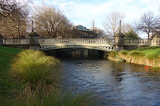
Hamish Hay Bridge is located in Victoria Square, Christchurch, New Zealand. Built in 1864, it was renamed in 1989 for Sir Hamish Hay, Mayor of Christchurch; a commemorative bronze plaque is affixed to the bridge's guard rail in the middle of the structure to honor Hay's services. The bridge, the oldest heritage feature in the square, is also the country's oldest cast iron and stone bridge. It survived the 2011 earthquake undamaged. Architectural features include the bridge arch and the balustrade's neo-gothic ornamentation. The bridge is registered as a Category II heritage structure with the New Zealand Historic Places Trust.

<span class="mw-page-title-main">2016 Christchurch earthquake</span> Earthquake in New Zealand

An earthquake occurred in Christchurch on 14 February 2016 at 1:13 p.m. local time and initially recorded as 5.9 on the Richter scale, but subsequently reviewed as 5.7. Often referred to as the Valentine's Day earthquake, it was centred in the sea off New Brighton at a depth of 15 kilometres (9.3 mi). It was the first large earthquake that the Christchurch area had experienced since May 2012, and it was part of the earthquake sequence that started with the 4 September 2010 Canterbury earthquake.

<span class="mw-page-title-main">Shand's Emporium</span>

Shand's Emporium, previously known as Gee's, is a historic building in the central city of Christchurch, New Zealand. One of the oldest commercial buildings to remain from the time Christchurch was founded, it was relocated in June 2015 from its original location in Hereford Street to Manchester Street, where it is placed adjacent to another heritage building, The Octagon.

<span class="mw-page-title-main">Antigua Boat Sheds</span>

The Antigua Boat Sheds in Christchurch, New Zealand is an historic building on the banks of the Avon River. It is possibly the only 19th-century example of a commercial boat shed situated on a river in New Zealand. It has been used as a boat shed continuously since its completion in 1882.

<span class="mw-page-title-main">Worcester Street, Christchurch</span> Street in Christchurch, New Zealand

Worcester Street is a road in the central city of Christchurch, New Zealand. It runs from the intersection of Rolleston Avenue in the west, and terminates in the east at the intersection of Woodham Road in Linwood. Between Rolleston Avenue and Cambridge Terrace, it is known as Worcester Boulevard.

References

  1. 1 2 Harper, Margaret (February 2016). "Christchurch Street Names N to O" (PDF). Christchurch City Libraries. pp. 16f. Retrieved 28 February 2016.
  2. 1 2 R., Donna (1 April 2015). "New Regent Street". Christchurch City Libraries . Retrieved 26 February 2016.
  3. 1 2 Dryden, John (February 1993). "The Legacy of Thomas Edmonds" (PDF). Christchurch: Christchurch City Council. pp. 12f. Retrieved 27 February 2016.
  4. "General News". The Press . Vol. LXVII, no. 20135. 14 January 1931. p. 8. Retrieved 27 February 2016.
  5. "Notes". The Press . Vol. LXVII, no. 20148. 29 January 1931. p. 4. Retrieved 27 February 2016.
  6. "Town Planning". The Press . Vol. LXV, no. 19785. 25 November 1929. p. 10. Retrieved 27 February 2016.
  7. 1 2 "Spanish Street". The Press . Vol. LXV, no. 19801. 13 December 1929. p. 14. Retrieved 27 February 2016.
  8. "New City Street". The Press . Vol. LXV, no. 19802. 14 December 1929. p. 16. Retrieved 27 February 2016.
  9. 1 2 3 "Claim for £1000". The Press . Vol. LXVIII, no. 20713. 25 November 1932. p. 8. Retrieved 28 February 2016.
  10. "The New Street". The Press . Vol. LXVI, no. 19847. 7 February 1930. p. 12. Retrieved 28 February 2016.
  11. 1 2 3 "New Regent Street Historic Area". New Zealand Heritage List/Rārangi Kōrero. Heritage New Zealand . Retrieved 27 February 2016.
  12. "January Permits". The Press . Vol. LXVII, no. 20154. 5 February 1931. p. 4. Retrieved 27 February 2016.
  13. "Regent Street". The Press . Vol. LXVI, no. 19918. 3 May 1930. p. 9. Retrieved 28 February 2016.
  14. 1 2 3 "Modern Business Thoroughfare". The Press . Vol. LXVIII, no. 20510. 1 April 1932. p. 4. Retrieved 27 February 2016.
  15. 1 2 3 4 5 "New Regent Street". The Press . Vol. LXVIII, no. 20511. 2 April 1932. p. 16. Retrieved 28 February 2016.
  16. "Local and General News". The New Zealand Herald . Vol. LXVIII, no. 20827. 20 March 1931. p. 10. Retrieved 27 February 2016.
  17. Harper, Margaret (February 2016). "Christchurch Street Names R" (PDF). Christchurch City Libraries. p. 94. Retrieved 28 February 2016.
  18. "New Regent Street". The Press . Vol. LXVIII, no. 20505. 26 March 1932. p. 16. Retrieved 27 February 2016.
  19. "Good-humoured crowd". Auckland Star . Vol. LXIII, no. 78. 2 April 1932. p. 7. Retrieved 28 February 2016.
  20. 1 2 3 4 5 "New Regent Street Terrace Shops". New Zealand Heritage List/Rārangi Kōrero. Heritage New Zealand . Retrieved 27 February 2016.
  21. "Claim for £1000". The Press . Vol. LXVIII, no. 20715. 28 November 1932. p. 5. Retrieved 28 February 2016.
  22. "Claim for £1000". The New Zealand Herald . Vol. LXIX, no. 21351. 28 November 1932. p. 9. Retrieved 28 February 2016.
  23. "General News". The Press . Vol. LXIX, no. 20828. 11 April 1933. p. 8. Retrieved 28 February 2016.
  24. "Regent Street Limited". The Press . Vol. LXIX, no. 20800. 9 March 1933. p. 3. Retrieved 28 February 2016.
  25. "Fortnight to pay". Auckland Star . Vol. LXIV, no. 57. 9 March 1933. p. 14. Retrieved 28 February 2016.
  26. "Sale of Property". The Press . Vol. LXXXI, no. 24737. 30 November 1945. p. 6. Retrieved 28 February 2016.
  27. 1 2 3 "New Regent Street - the most beautiful street in New Zealand". Christchurch & Canterbury Tourism. Archived from the original on 22 February 2016. Retrieved 28 February 2016.
  28. "New Regent Street, Christchurch". Naylor Love. Retrieved 28 February 2016.
  29. "New Regent Street". Fulton Ross Team Architects. Retrieved 28 February 2016.
  30. 1 2 Gates, Charlie (16 April 2013). "New Regent St reopens with five shops". The Press . Retrieved 28 February 2016.
  31. 1 2 3 4 Cairns, Lois (26 February 2016). "Owner urged to fix buildings". The Press . p. A3. Retrieved 28 February 2016.
  32. Gates, Charlie (29 November 2013). "New Regent St fence being removed". The Press . Retrieved 28 February 2016.
  33. O'Callaghan, Jody (10 November 2014). "Christchurch trams get back on track". The Press . Retrieved 29 February 2016.
  34. Hobson, Brooke; Mead, Thomas (25 February 2016). "Trams come to a halt on New Regent Street". Newshub . Retrieved 29 February 2016.
  35. 1 2 3 Spink, Emily (2 May 2016). "New Regent Street back on track for trams". The Press . p. A3. Retrieved 4 May 2016.
  36. Cairns, Lois (27 February 2016). "Cracks in New Regent St impasse as city, shops suffer". The Press . p. A3. Retrieved 29 February 2016.
  37. "New Regent Street". Future Christchurch. Retrieved 29 February 2016.