
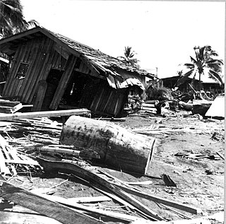
The 2007 Gisborne earthquake occurred under the Pacific Ocean about 50 kilometres (31 mi) off the eastern coast of New Zealand's North Island at 8:55 pm NZDT on 20 December. With a moment magnitude of 6.7 and maximum Mercalli intensity of VII, the tremor affected the city of Gisborne and was felt widely throughout the country, from Auckland in the north to Dunedin in the south.

Gisborne District or the Gisborne Region is a local government area of northeastern New Zealand. It is governed by Gisborne District Council, a unitary authority. It is named after its largest settlement, the city of Gisborne. The region is also commonly referred to as the East Coast.
The 1922 Vallenar earthquake occurred with a moment magnitude of 8.3 and a tsunami magnitude of 8.7 in the Atacama Region of Chile, near the border with Argentina on 11 November at 04:32 UTC. It triggered a destructive tsunami that caused significant damage to the coast of Chile and was observed as far away as Australia.
The 1976 Moro Gulf earthquake and tsunami occurred on near the islands of Mindanao and Sulu, in the Philippines. It measured 8.0 on the moment magnitude scale occurring at a depth of 20 km (12 mi). The earthquake was accompanied by a destructive tsunami that resulted in a majority of the estimated 5,000 to 8,000 fatalities. It was the deadliest and strongest earthquake in the Philippines in 58 years since the 1918 Celebes Sea earthquake.

The 2009 Dusky Sound earthquake was a 7.8 earthquake that struck a remote region of Fiordland, New Zealand, on 15 July at 21:22 local time. It had an initially–reported depth of 12 km (7.5 mi), and an epicentre near Dusky Sound in Fiordland National Park, which is 160 km (99 mi) north-west of Invercargill. It was the country's largest earthquake magnitude since the 1931 Hawke's Bay earthquake, but caused only minor damage and there were no casualties. A tsunami accompanied the event and had a maximum measured run-up of 230 cm (91 in).
The 2014 Eketāhuna earthquake struck at 3:52 pm on 20 January, centred 15 km east of Eketāhuna in the south-east of New Zealand's North Island. It had a maximum perceived intensity of VII on the Mercalli intensity scale. The magnitude 6.2 earthquake was followed by a total of 1,112 recorded aftershocks, ranging between magnitudes 2.0 and 4.9.
The 1863 Hawke's Bay earthquake was a devastating magnitude 7.5 earthquake that struck near the town of Waipukurau on 23 February 1863. It remained the single largest earthquake to strike Hawke's Bay until 1931, where a magnitude 7.8 quake levelled much of Napier and Hastings, and killed 256 people.
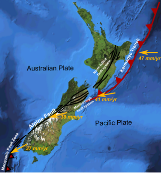
The Hikurangi Margin is New Zealand's largest subduction zone and fault.
The 1904 Cape Turnagain earthquake struck 10 kilometres (6.2 mi) north of Cape Turnagain on the morning of 9 August with a magnitude estimated at 6.8 and 7.0–7.2 . It was felt throughout the North Island and upper South Island, with many communities within a 500 kilometres (310 mi) radius reporting noticeable ground shaking. Heavy damage occurred to the landscape and personal property and one man died. It was the largest to strike New Zealand since the 7.0 Mw North Canterbury earthquake in 1888.

The 2016 Kaikōura earthquake was a 7.8 earthquake in the South Island of New Zealand that occurred two minutes after midnight on 14 November 2016 NZDT. Ruptures occurred on multiple faults and the earthquake has been described as the "most complex earthquake ever studied". It has been subsequently modelled as having a megathrust component set off by an adjacent rupture on the Humps Fault. It was the second largest earthquake in New Zealand since European settlement.
The 2003 Fiordland earthquake struck the remote region of Fiordland in the South Island of New Zealand on 22 August 2003, at 12:12 am NZST. The epicentre was 12 kilometres (7.5 mi) deep, and was thought to be near Secretary Island at the entrance to Doubtful Sound. At 7.2 Ms magnitude, it was one of the largest quakes in the country for some time, and was the largest shallow quake since the 1968 Inangahua earthquake. There was an aftershock two hours later at 2:12 am, followed over several days by frequent small tremors; two months after the earthquake, there had been 8,000 aftershocks.

Laura Martin Wallace is a geodetic principal scientist who works between the University of Texas at Austin and GNS Science in New Zealand. She was elected Fellow of the Royal Society Te Apārangi in 2018.
The 2021 Kermadec Islands earthquakes were a series of earthquakes with magnitudes of 8.1 and 7.4 that occurred at 19:28:31 UTC on 4 March 2021. The epicentres were located southeast of Raoul Island in the Kermadec Islands, part of the New Zealand outlying islands. The main magnitude 8.1 earthquake was preceded by a magnitude 7.4 foreshock and followed by a magnitude 6.1 aftershock. A separate, unrelated magnitude 7.3 earthquake occurred off the coast of the North Island of New Zealand, approximately 900 km to the south, several hours before the main quakes. More than a dozen aftershocks exceeded magnitude 6.
The Nemuro-Oki earthquake in scientific literature, occurred on June 17 at 12:55 local time. It struck with an epicenter just off the Nemuro Peninsula in northern Hokkaidō, Japan. It measured 7.8–7.9 on the moment magnitude scale (Mw ), 8.1 on the tsunami magnitude scale (Mt ) and 7.4 on the Japan Meteorological Agency magnitude scale (MJMA ).

The 1585 Aleutian Islands earthquake is the presumed source of a tsunami along the Sanriku coast of Japan on 11 June 1585, known only from vague historical accounts and oral traditions. The event was initially misdated to 1586, which led to it being associated with the deadly earthquakes in Peru and Japan of that year. A megathrust earthquake on the Aleutian subduction zone in the North Pacific Ocean was hypothesized as the tsunami's source. Paleotsunami evidence from shoreline deposits and coral rocks in Hawaii suggest that the 1585 event was a large megathrust earthquake with a moment magnitude (Mw ) as large as 9.25.

An earthquake occurred off the coast of the Alaska Peninsula on July 28, 2021, at 10:15 p.m. local time. The large megathrust earthquake had a moment magnitude of 8.2 according to the United States Geological Survey (USGS). A tsunami warning was issued by the National Oceanic and Atmospheric Administration (NOAA) but later cancelled. The mainshock was followed by a number of aftershocks, including three that were of magnitude 5.9, 6.1 and 6.9 respectively.
The 1841 Kamchatka earthquake occurred in the Pacific Ocean on May 17 at 08:00 local time. The earthquake had an epicenter off the Russian Far East's Kamchatka Peninsula. With an estimated moment magnitude of 9.0 or higher, it is one of the largest to strike the region. A large tsunami with a run-up height of up to 15 metres (49 ft) struck the coast.
In 1914, two earthquakes shook the upper North Island of New Zealand, on Wednesday 7 October and Wednesday 28 October. They were large and shallow, with their epicentres close together northwest of Ruatoria in the Gisborne District. The earthquakes were felt strongly throughout the East Cape area, most noticeably in areas east of the epicentre such as Waipiro Bay, with a large amount of damage occurring in Tokomaru Bay in particular. One person was killed by a landslide near Cape Runaway.

The Shōnai offshore earthquake occurred at around 14:00 on December 7, 1833. It struck with an epicenter in the Sea of Japan, off the coast of Yamagata Prefecture, Japan. A tsunami was triggered by the estimated MJMA 7.5–7.7 earthquake. One hundred and fifty people were killed and there was severe damage in the prefecture.

