Related Research Articles

The D'Urville River is in the South Island of New Zealand.

Arthur's Pass, a mountain pass in the Southern Alps of the South Island of New Zealand, marks part of the boundary between the West Coast and Canterbury regions. Located 140 km from Christchurch and 95 km from Greymouth, the pass comprises part of a saddle between the valleys of the Otira River and of the Bealey River. Arthur's Pass lies on the border of the Selwyn and Westland districts.

The Canterbury Plains is an area in New Zealand centred in the Mid Canterbury, to the south of the city of Christchurch in the Canterbury region. Their northern extremes are at the foot of the Hundalee Hills in the Hurunui District, and in the south they merge into the plains of North Otago beyond the Waitaki River.

The Waimakariri River is one of the largest rivers in Canterbury, on the eastern coast of New Zealand's South Island. It flows for 151 kilometres (94 mi) in a generally southeastward direction from the Southern Alps across the Canterbury Plains to the Pacific Ocean.

The Kaiapoi River is a minor river of north Canterbury, in New Zealand's South Island. Originally called the Cam River, it is a tributary of the Waimakariri River, which it joins at the larger river's estuary. The river is 16 kilometres (10 mi) long, and its drainage area is about 430 square kilometres (170 sq mi).
Craigieburn is the name of a settlement and several geographic features in northwest Canterbury, in New Zealand's South Island.

Selwyn District is a predominantly rural area in central Canterbury, on the east coast of New Zealand's South Island. It is named after the Selwyn River / Waikirikiri, which is in turn named after Bishop George Selwyn, the first Anglican bishop of New Zealand who, in 1843 and 1844, travelled the length of the country by horse, foot, boat and canoe, leaving in his wake a sprinkling of locations that now bear his name.

Waimakariri District is a local government district, located in the Canterbury region of New Zealand's South Island. It is named after the Waimakariri River, which forms the district's southern boundary, separating it from Christchurch City and the Selwyn District. It is bounded in the north by the Hurunui District and in the east by the Pacific Ocean.
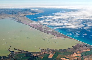
Kaitorete Spit is a long finger of land which extends along the coast of Canterbury in the South Island of New Zealand. It runs west from Banks Peninsula for 25 kilometres, and separates the shallow Lake Ellesmere / Te Waihora from the Pacific Ocean. It is technically a continuous barrier beach, though at its western end it tapers to a point less than 100 metres in width which is occasionally breached at high tide. The spit is noted for its isolation and for its pebbly beaches. At its eastern end is the small settlement of Birdlings Flat, and west of its narrowest point is the settlement of Taumutu.

Eyreton, originally known as Eyretown, is a small village in the Canterbury region of New Zealand's South Island. It is named after Edward John Eyre, who at one time was the lieutenant governor of the South Island. It is a rural village located to the west of Kaiapoi, near the north bank of the Waimakariri River, and the 2001 New Zealand census revealed that 2,139 people lived in Eyreton and the surrounding area. This was an increase of 624 people, or 41.1%, since the 1996 census.
Waddington is a small village located in the Selwyn District of the Canterbury region of New Zealand's South Island, near the Waimakariri Gorge.

The Pines Beach is a small town situated roughly 4 km east of Kaiapoi in the Canterbury region of the South Island of New Zealand. It is 1 km north of the mouth of the Waimakariri River. It takes its name from its close proximity to both a pine forest and the beach.
The Cust River is a river in the Canterbury region of New Zealand. It flows east across the upper Canterbury Plains from its source north of the town of Oxford, New Zealand, flowing into the Cam River / Ruataniwha close to the town of Rangiora. The small town of Cust lies on the banks of the river. The lower part of the river, to the south-west of Rangiora, is diverted into a channel and called the "Main Drain". The channel was built in 1862 to drain the swampy land between Rangiora and the Waimakariri River, and when it was enlarged in 1868 it accidentally captured the Cust.
The Garry River is a river in the Canterbury region of New Zealand. It arises in the Mount Thomas Forest near Mount Thomas and flows south-east into Ashley River / Rakahuri. Blowhard Stream is a tributary.
The Glentui River is a river in the Canterbury region of New Zealand. It arises on the slopes of Mount Richardson and flows south-east through the locality of Glentui and into Ashley River / Rakahuri, which exits in the Pacific Ocean. The river was earlier called Tui Creek, and the locality named from the station Glentui established by H.C.H. Knowles in 1854.
The Eyre River is a river in the Canterbury region of New Zealand. It arises in the Puketeraki Range and flows south-east into the Waimakariri River near Christchurch International Airport. The connection with the Waimakariri is via a diversion channel running south-west, replacing the Eyre's original easterly flow. The river is named after Edward John Eyre, the Lieutenant-Governor of New Munster from 1848–53.
Canterbury's Esk River is a tributary of the Waimakariri River. It rises in the Dampier Range near Esk Head, and flows southwest on the western side of the Puketeraki Range to reach the upper Waimakariri some 20 kilometres (12 mi) north of Springfield.

Peraki, a Māori language place name with an initial spelling of Pireka, is a bay on the south side of Banks Peninsula, New Zealand. It is the site of the first permanent European settlement in Canterbury. George Hempelman, a Prussian whaler, established a whaling station in the bay in 1835, and from 1837 lived there permanently. Peraki has a small cemetery, one of the earliest European cemeteries in New Zealand.
Mandeville North is a small village in the Waimakariri District of Canterbury, New Zealand. Due to new subdivisions being built in the area, the population has been slowly increasing, particularly after the 2011 Christchurch earthquake. The construction of the Mandeville village retail development began in late 2017 and was completed in early 2018.
Oaro is a settlement close to the Pacific Ocean Coast of north Canterbury, in the South Island of New Zealand.
References
- 1 2 Dowling, P. (ed.) (2004). ’’Reed New Zealand atlas’’. Auckland: Reed Publishing. ISBN 0 7900 0952 8. Map 82.
- ↑ Wise's New Zealand guide (1969) Dunedin: H. Wise & Co., p. 110.
Coordinates: 43°24′39″S172°39′45″E / 43.41083°S 172.66250°E
| | This Canterbury Region-related geography article is a stub. You can help Wikipedia by expanding it. |