Redcliffs

Last updated

Redcliffs
Barnett Park, Redcliff.jpg
Barnett Park
Redcliffs
Coordinates: 43°33′47″S172°43′52″E / 43.563°S 172.731°E / -43.563; 172.731
CountryNew Zealand
City Christchurch
Local authority Christchurch City Council
Electoral wardHeathcote
Community board Waihoro Spreydon-Cashmere-Heathcote
Area
[1]
  Land185 ha (457 acres)
Population
 (June 2023) [2]
  Total2,070
(Avon Heathcote Estuary / Ihutai)
Mount Pleasant
Pfeil oben.svg
Pfeil links.svgRedcliffsPfeil rechts.svg
Pfeil unten.svg
Heathcote Valley (Port Hills) Moncks Bay

Redcliffs is an outer coastal suburb of Christchurch, Canterbury, New Zealand.

Contents

History

The area of Redcliffs was first populated by humans about 700 years ago. In the 14th century, large groups of Māori, initially the Waitaha people and then the Ngāti Māmoe tribe, settled in the area. The Ngāi Tahu eventually displaced Ngāti Māmoe and were still living in the area when the first Europeans arrived. [3]

The Māori name for the mudflats near the suburb is Ohikaparuparu, it is an important shellfish gathering site for Māori. [4]

The Moa Bone Point Cave (Te Ana o Hineraki) in Redcliffs was excavated under the direction of Julius von Haast in 1872, and numerous artefacts were found. [5] Many further investigations have been undertaken since that time. Artefacts found included moa bones and egg shells, bones of seals, birds and fish, shellfish and many Māori taonga. This suggests that Moa Bone Point Cave was used as shelter by the first Māori people but also used as a place to store valuable items. [6]

Moncks Cave is another smaller cave located in Redcliffs. It was discovered by road workers in 1889, and is considered to be one of the greatest archaeological sites in New Zealand because of the evidence that it has provided of early Māori occupation, including wooden artefacts. [7] [8]

Location

The suburb is most directly accessed from the city centre by a causeway that crosses the Avon Heathcote Estuary and is the suburb immediately before Sumner. Alternatively, Redcliffs can be accessed through McCormack's Bay Road, which circles the perimeter of the Avon Heathcote Estuary. [9] The coastal road from Redcliffs to Sumner allows for further access to the port and suburb of Lyttelton and the Port Hills, and an alternative—if long—route to the city centre.

Geology

Redcliffs is characterised by rocky, hilly geography and has many natural caves in its sides. The domineering cliffs of Redcliffs are a snapshot of the region's volcanic origins. The cliffs are tinged with veins of red tephra, and composed of 'A'ā lava flows; the suburb draws its name from this the most notable of its physical features.

Demographics

Redcliffs covers 1.85 km2 (0.71 sq mi). [1] It had an estimated population of 2,070 as of June 2023, [2] with a population density of 1,119 people per km2.

Historical population
YearPop.±% p.a.
20062,079    
20131,776−2.23%
20181,971+2.11%
Source: [10]

Redcliffs had a population of 1,971 at the 2018 New Zealand census, an increase of 195 people (11.0%) since the 2013 census, and a decrease of 108 people (−5.2%) since the 2006 census. There were 822 households, comprising 933 males and 1,035 females, giving a sex ratio of 0.9 males per female. The median age was 49.3 years (compared with 37.4 years nationally), with 276 people (14.0%) aged under 15 years, 285 (14.5%) aged 15 to 29, 957 (48.6%) aged 30 to 64, and 453 (23.0%) aged 65 or older.

Ethnicities were 93.2% European/Pākehā, 7.3% Māori, 0.8% Pasifika, 4.3% Asian, and 2.7% other ethnicities. People may identify with more than one ethnicity.

The percentage of people born overseas was 24.4, compared with 27.1% nationally.

Although some people chose not to answer the census's question about religious affiliation, 54.3% had no religion, 35.5% were Christian, 0.2% had Māori religious beliefs, 0.8% were Hindu, 1.1% were Muslim, 0.8% were Buddhist and 1.7% had other religions.

Of those at least 15 years old, 615 (36.3%) people had a bachelor's or higher degree, and 144 (8.5%) people had no formal qualifications. The median income was $43,200, compared with $31,800 nationally. 483 people (28.5%) earned over $70,000 compared to 17.2% nationally. The employment status of those at least 15 was that 783 (46.2%) people were employed full-time, 291 (17.2%) were part-time, and 39 (2.3%) were unemployed. [10]

The suburb is affluent by New Zealand standards and property values are relatively high, with the average house costing NZ$450,000 in 2006. [11] Redcliffs has a significant number of baby boomers.

Recreation

Barnett Park, open to public access, and a product of the earliest council recreation planning in the wider Christchurch region, is located in Redcliffs. [9] The suburb also hosts a bowling green, and a smaller park adjacent to the estuary which bears the suburb's name, Redcliffs Park.

Earthquake damage to a house in Redcliffs Earthquake damage to stately home in Redclifts - panoramio.jpg
Earthquake damage to a house in Redcliffs

2011 Christchurch earthquake

A landslide against the cliffs beside Redcliffs School, occurring from the 2011 Christchurch earthquake Redcliffs landslide1.JPG
A landslide against the cliffs beside Redcliffs School, occurring from the 2011 Christchurch earthquake

In contrast to the September 2010 earthquake, Redcliffs and the surrounding hills suffered significant damage in the 22 February 2011 earthquake. Dozens of houses were deemed unliveable and hundreds more damaged. There was a large scale evacuation of several streets in Redcliffs at 10pm on Thursday, 24 February after some cliffs surrounding Redcliffs were deemed unstable. The following morning, a few streets or partial streets remained cordoned off but many people were able to return to their homes immediately. [12] [13]

By 7 March, detailed geotechnical inspections of the affected land inside the remaining cordons began with a view to removing them. They were removed on 8 March. [14]

Redcliffs citizens launched a local information centre on 26 February, followed by a regular newsletter from 27 February, [15] followed by two support websites. [16]

On 2 March, Redcliffs resident Peter Hyde launched a viral call [17] to encourage more support, especially key supplies and information, for the worst affected Eastern suburbs of Christchurch. In particular those to the north of Redcliffs such as Parklands, Aranui, Bromley, Avonside, Bexley and New Brighton.

Redcliffs School

Te Raekura Redcliffs School is a full primary school catering for years 1 to 8. [18] It had a roll of 215 as of February 2024. [19]

The school opened in 1907. [20] It was temporarily relocated to Van Asch Deaf Education Centre, 4.5 kilometres (2.8 mi) from the original Main Road site, after the June 2011 aftershock. This decision came after concerns of the safety of pupils as the cliffs behind the school became unstable. [21] In 2015 and 2016, Redcliffs School faced the risk of closure due to the risk of further disruption. After community backlash, it was decided to build a new site in Redcliffs Park, across the road from the original site. The new site was opened in June 2020. [22] [23]

Related Research Articles

<span class="mw-page-title-main">South Island</span> One of the two main New Zealand islands

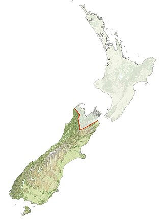
The South Island, also named Te Waipounamu in Māori, is the larger of the two major islands of New Zealand in surface area, the other being the smaller but more populous North Island. It is bordered to the north by Cook Strait, to the west by the Tasman Sea, and to the south and east by the Pacific Ocean. The South Island covers 150,437 square kilometres (58,084 sq mi), making it the world's 12th-largest island, constituting 56% of New Zealand's land area. At low altitude, it has an oceanic climate.

<span class="mw-page-title-main">Banks Peninsula</span> Peninsula south of Christchurch, New Zealand

Banks Peninsula is a peninsula of volcanic origin on the east coast of the South Island of New Zealand. It has an area of approximately 1,150 square kilometres (440 sq mi) and encompasses two large harbours and many smaller bays and coves. The South Island's largest city, Christchurch, is immediately north of the peninsula.

<span class="mw-page-title-main">Sumner, New Zealand</span> Suburb of Christchurch, New Zealand

Sumner is a coastal seaside suburb of Christchurch, New Zealand and was surveyed and named in 1849 in honour of John Bird Sumner, the then newly appointed Archbishop of Canterbury and president of the Canterbury Association. Originally a separate borough, it was amalgamated with the city of Christchurch as communications improved and the economies of scale made small town boroughs uneconomic to operate.

<span class="mw-page-title-main">Riverton / Aparima</span> Town in the South Island of New Zealand

Riverton, officially Riverton / Aparima, is a small New Zealand town 30 kilometres (19 mi) west of Invercargill, on the south-eastern shorelines of the Jacobs River Estuary. The estuary is formed by the Aparima and Pourakino rivers, leading through a narrow outflow channel into Foveaux Strait. Accessible via State Highway 99 on the Southern Scenic Route, the main part of the town is on flat land and the northern end of Oreti Beach. South Riverton is built on the hills between the eastern shore of the estuary and Taramea Bay.

<span class="mw-page-title-main">Ngāi Tahu</span> Māori iwi in New Zealand

Ngāi Tahu, or Kāi Tahu, is the principal Māori iwi (tribe) of the South Island. Its takiwā is the largest in New Zealand, and extends from the White Bluffs / Te Parinui o Whiti, Mount Mahanga and Kahurangi Point in the north to Stewart Island / Rakiura in the south. The takiwā comprises 18 rūnanga corresponding to traditional settlements. According to the 2018 census an estimated 74,082 people affiliated with the Kāi Tahu iwi.

<span class="mw-page-title-main">Keri Hulme</span> New Zealand writer (1947–2021)

Keri Ann Ruhi Hulme was a New Zealand novelist, poet and short-story writer. She also wrote under the pen name Kai Tainui. Her novel The Bone People won the Booker Prize in 1985; she was the first New Zealander to win the award, and also the first writer to win the prize for a debut novel. Hulme's writing explores themes of isolation, postcolonial and multicultural identity, and Māori, Celtic, and Norse mythology.

<span class="mw-page-title-main">New Brighton, New Zealand</span> Coastal suburb of Christchurch, NZ

New Brighton is a coastal suburb of Christchurch, New Zealand, 8 kilometres (5.0 mi) east of the city centre. It is one of eastern Christchurch's main entertainment and tourist centres, with its architecturally unique pier and scenic coastline. The 2011 Christchurch earthquakes caused significant damage in the area.

<span class="mw-page-title-main">Heathcote Valley</span> Suburb of Christchurch, New Zealand

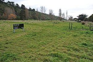
Heathcote Valley is a suburb of Christchurch, New Zealand. It is named after Sir William Heathcote, who was secretary of the Canterbury Association.

<span class="mw-page-title-main">Cashmere, New Zealand</span> Suburb of Christchurch, New Zealand

Cashmere is a suburb which rises above the southern end of the city of Christchurch in New Zealand's South Island.

Kāti Māmoe is a historic Māori iwi. Originally from the Hastings area, they moved in the 16th century to the South Island which at the time was already occupied by the Waitaha.

<span class="mw-page-title-main">Spreydon</span> Suburb of Christchurch, New Zealand

Spreydon is a suburb of Christchurch, New Zealand, 4 kilometres (2.5 mi) south-south-west of Cathedral Square. The most central street through Spreydon is Barrington Street. Spreydon is flanked by the suburbs Hoon Hay, Sydenham, and Lower Cashmere. State Highway 76 marks the northern boundary of the suburb, including the eastern end of the Christchurch Southern Motorway.

<span class="mw-page-title-main">Linwood, New Zealand</span> Suburb of Christchurch, New Zealand

Linwood is an inner suburb of the city of Christchurch, New Zealand. It lies to the east of the city centre, mostly between Ferry Road and Linwood Avenue, two of the major arterial roads to the eastern suburbs of Christchurch.

Heretaunga is a suburb of the city of Upper Hutt, located in the lower (southern) North Island of New Zealand. The settlement, one of the older suburbs in the Hutt Valley, dates from the 1840s when European settlers sought country sections. A prime example of a "leafy" suburb, Heretaunga includes quiet tree-lined streets. It is characterised by large houses, often Edwardian or from the mid-20th century.

<span class="mw-page-title-main">Somerfield, New Zealand</span> Suburb of Christchurch, New Zealand

Somerfield is a suburb in the south of Christchurch, New Zealand. It is nominally bordered by the Ōpāwaho / Heathcote River to the south and west, Strickland and Colombo Streets to the east, and Milton Street to the north. The suburb includes Somerfield School, Somerfield Park and a small number of shops which service the local area, although it is predominantly residential. Somerfield is also known for its wide variety of trees, especially along the banks of the Ōpāwaho / Heathcote River.

<span class="mw-page-title-main">Wairau Bar</span> Archeologically important gravel bar on the North Island of New Zealand

The Wairau Bar, or Te Pokohiwi, is a 19-hectare (47-acre) gravel bar formed where the Wairau River meets the sea in Cloudy Bay, Marlborough, north-eastern South Island, New Zealand. It is an important archaeological site, settled by explorers from East Polynesia who arrived in New Zealand about 1280. It is one of the earliest known human settlements in New Zealand. At the time of the occupation it is believed to have been a low scrub-covered island 2 to 3 metres high, 1.1 kilometres (0.68 mi) long and 0.4 kilometres (0.25 mi) wide.

<span class="mw-page-title-main">Southshore, New Zealand</span> Suburb of Christchurch, New Zealand

Southshore is an eastern coastal suburb within Christchurch, New Zealand. It is sited on a narrow 2.5 km (1.6 mi) long sandspit that runs along the eastern side of the Avon Heathcote Estuary and is 8 km (5.0 mi) eastwards from the city centre. The area occupying the modern-day suburb previously had some Māori presence, which is supported by pre-European artefacts discovered in the area, the suburb being rich with birdlife and wildlife and considered an important food-gathering place by local tribes.

<span class="mw-page-title-main">South New Brighton</span> Suburb of Christchurch, New Zealand

South New Brighton is a coastal suburb on the eastern side of Christchurch city.

<span class="mw-page-title-main">Moncks Cave</span> Cave located in Redcliffs, Christchurch

Moncks Cave is a cave located in Redcliffs, Christchurch, New Zealand. The cave was uncovered by road workers in 1889, and is considered to be one of the greatest archaelogical sites in New Zealand. It is notable for the evidence that it has provided of early Māori occupation.

<span class="mw-page-title-main">Bromley, New Zealand</span> Suburb of Christchurch, New Zealand

Bromley is a suburb of the city of Christchurch, New Zealand. It lies to the east of the city centre, mostly between Pages Road and the Avon river estuary.

Christchurch is a major city in the Canterbury Region, and is the largest city in the South Island of New Zealand. Established as an outpost of the British Empire in 1850, it is today the second largest city in New Zealand, after Auckland.

References

  1. 1 2 "ArcGIS Web Application". statsnz.maps.arcgis.com. Retrieved 22 December 2023.
  2. 1 2 "Population estimate tables - NZ.Stat". Statistics New Zealand . Retrieved 25 October 2023.
  3. "About Redcliffs » Redcliffs Residents Association". redcliffs.org.nz. Retrieved 30 September 2019.
  4. Tau, T.M; Goodall, A.; Palmer, D. (1990). "Te Whakatau Kaupapa: Ngai Tahu resource management strategy for the Canterbury Region". Aoraki Press. Wellington, New Zealand. pp. 5–24.
  5. "Where the Maori trod". Taranaki Daily News. 4 January 1933. p. 8 via Papers Past.
  6. "Te Ana o Hineraki – Moa Bone Point Cave". my.christchurchcitylibraries.com. Retrieved 30 September 2019.
  7. "Moncks Cave treasures". The Press . 7 March 1987. p. 22. Retrieved 3 May 2024 via Papers Past.
  8. "Redcliffs". New Zealand Heritage List/Rārangi Kōrero. Heritage New Zealand.
  9. 1 2 CCC, 1984
  10. 1 2 "Statistical area 1 dataset for 2018 Census". Statistics New Zealand. March 2020. Redcliffs (332100). 2018 Census place summary: Redcliffs
  11. Real Estate Institute of New Zealand
  12. "Television | Scoop News". Scoop.co.nz. Retrieved 14 August 2013.
  13. "New Zealand earthquake: Hopes fade for 200 missing". BBC News. 24 February 2011. Retrieved 14 August 2013.
  14. Hyde, Peter. "Tuesday March 8, 6pm". Redcliffs Community NewsSheet. Webcentre Ltd. Retrieved 8 March 2011.
  15. Hyde, Peter. "Redcliffs Community NewsSheet" (PDF). Redcliffs Community NewsSheet #1. Webcentre Ltd.
  16. "Redcliffs Community NewsSheet – Webcentre Ltd". Webcentre.co.nz. Retrieved 14 August 2013.
  17. Hyde, Peter. "Christchurch Quake – More Action Needed in Eastern Suburbs Right Now". Webcentre.co.uk.
  18. Education Counts: Te Raekura Redcliffs School
  19. "New Zealand Schools Directory". New Zealand Ministry of Education. Retrieved 14 March 2024.
  20. "History". Te Raekura Redcliffs School. 7 June 2019.
  21. "Christchurch's Redcliffs School move to be fast tracked". Stuff. Retrieved 30 September 2019.
  22. "Redcliffs School returns home after nine years". Stuff. 21 June 2020. Retrieved 1 July 2020.
  23. Admin. "Principal's Welcome". Redcliffs School. Retrieved 30 September 2019.