
Waltham is an inner suburb of Christchurch, New Zealand, located approximately two kilometres south-east of the city centre. State Highway 76, part of Christchurch's ring road system, and known there as Brougham Street, runs through the suburb, as does the Lyttelton Line rail corridor.
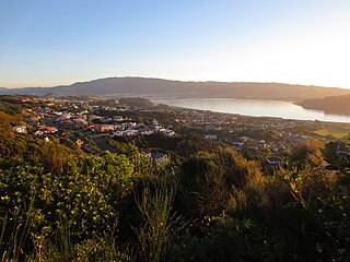
Papakōwhai is a suburb of Porirua City. It lies approximately 22 kilometres (14 mi) north of Wellington in New Zealand.

St Albans is a large, inner-northern suburb of Christchurch, New Zealand, located directly north of the Christchurch Central Business District. It is the second largest suburb in the city by population, with a population of 13,137 at the 2018 Census. The suburb falls within the Christchurch Central electorate and is represented by Duncan Webb, who has been the member of parliament since the 2017 general election. St Albans is one of the most diverse residential neighbourhoods in Christchurch, with a wide range of densities, architectural styles and housing ages throughout the suburb. It has everything from run-down high-density council-owned flats, to modern luxurious high-density flats and apartments; old mid-density workers cottages through to large low-density estates of various ages.

The suburb of Bexley is situated in East Christchurch on the west bank of the Avon River approximately one kilometre from the Avon Heathcote Estuary. It is enclosed within a bend in the Avon River and borders the suburb of Aranui.

Waipapa is a small town in the Bay of Islands, Northland, New Zealand. It is around 10 minutes drive from Kerikeri, the nearest urban centre to Waipapa, located on State Highway 10. Waipapa itself has no school and most people travel into Kerikeri on a daily basis. It is governed by the Far North District council.

Ōmokoroa is a small urban area in the Western Bay of Plenty District of New Zealand. The suburb is considered part of Greater Tauranga, and is within the Coromandel electorate. Ōmokoroa began as a small rural holiday village, but is expanding to be a commuter town, with a 25-minute drive to Tauranga City.

Frankleigh Park is a suburb of New Plymouth, in the western North Island of New Zealand. It is located to the south of the city centre. The suburb is built around the site of early settler Henry King's farm, Woodleigh, the father of William Cutfield King.
Wakari is a residential suburb of the New Zealand city of Dunedin. It is located 2.5 kilometres (1.6 mi) to the northwest of the city centre, immediately to the west of the ridge which runs to the west of the city's centre. Wakari lies to the north of the upper reaches of the Kaikorai Valley, and is also north of the suburb of Kaikorai. The suburbs of Roslyn and Maori Hill are situated on the ridge immediately to the southeast and east of Wakari. The suburb of Halfway Bush lies to the northwest, and the smaller suburb of Helensburgh lies to the north.
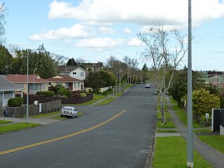
Fairview Downs is a suburb in eastern Hamilton in New Zealand.

Aranui is one of the eastern suburbs of Christchurch. It is a lower socio-economic area. The area is predominantly residential with pockets of light industry. There is a cluster of shops and service facilities at the intersection of Breezes Road and Pages Road.

Grenada North is a small suburb in northern Wellington, New Zealand. It is 5 km south of Porirua's city centre, and 13 km north of Wellington's city centre. Its western boundary is formed by State Highway 1 and Takapu Road. The suburb itself was named after Grenada in the Caribbean, and most streets are named after Caribbean islands.
One Tree Hill is a suburb of Auckland, New Zealand. The residential part of the suburb is located to the east and south-east of Maungakiekie / One Tree Hill, from which it takes its name, with the volcanic peak located within the suburb's boundaries.

Sockburn is an industrial suburb of Christchurch, New Zealand, located between Hornby and Riccarton, some 7 kilometres (4.3 mi) west of the Christchurch city centre. The suburb is roughly bounded by the triangle formed by State Highway 1 in the west, Main South Road (SH73a) in the south and SH73 in the north. The suburb of Wigram, containing the city's former RNZAF base, is located nearby. One of the city's main horseracing circuits, Riccarton Racecourse, is located close to Sockburn's northern edge, and Racecourse was the initial name for the area. The name Sockburn is likely to have come from the village of Sockburn in County Durham, England.

Fairy Springs is a suburb of Rotorua in the Bay of Plenty Region of New Zealand's North Island. It is located south of Ngongotahā, west of Koutu, east of Selwyn Heights, and north of Mangakakahi.
Middleton is a predominantly industrial and wholesale suburb of Christchurch, New Zealand. It is located in the west of the city, between Wigram and Addington, and immediately to the south of Upper Riccarton.
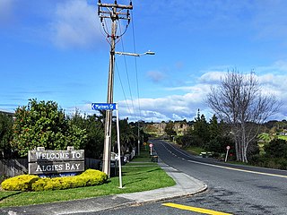
Algies Bay is a northern coastal suburb of Auckland, in New Zealand. It is on the Mahurangi Peninsula about 68 kilometres north of the city centre.

Schnapper Rock is a western suburb on the North Shore of Auckland. The suburb is currently under local governance of Auckland Council.
Pipitea is a central suburb of Wellington, in the Wellington region of New Zealand's North Island.

Marshland is a semi-rural suburb on the northern side of Christchurch city. The land is primarily used for horticulture and dairy farming.
Broomfield is a suburb on the western side of Christchurch city.

