Waltham, New Zealand

Last updated

Waltham
66 Laurence Street, Christchurch 008.JPG
Houses on Laurence Street
Waltham, New Zealand
Coordinates: 43°33′04″S172°38′49″E / 43.55109°S 172.64684°E / -43.55109; 172.64684
CountryNew Zealand
City Christchurch
Local authority Christchurch City Council
Electoral ward
  • Heathcote
  • Central
Community board
  • Waihoro Spreydon-Cashmere-Heathcote
  • Waipapa Papanui-Innes-Central
Area
[1]
  Land206 ha (509 acres)
Population
 (June 2023) [2]
  Total3,930
Christchurch Central City Phillipstown
Sydenham
Pfeil oben.svg
Pfeil links.svgWalthamPfeil rechts.svg
Pfeil unten.svg
Woolston
Beckenham St Martins Opawa

Waltham is an inner suburb of Christchurch, New Zealand, located approximately 2 kilometres (1.2 miles) south-east of the city centre. State Highway 76, part of Christchurch's ring road system, and known there as Brougham Street, runs through the suburb, as does the Lyttelton Line rail corridor.

Contents

Approximate boundaries of the suburb are Waltham Road, Moorhouse Avenue, Ferry Road, Ensors Road, and the Ōpāwaho / Heathcote River. Waltham was originally part of the Sydenham borough and was incorporated into the City of Christchurch in 1903 when the borough was ended. In the early 1980s local residents and the Christchurch city council tried to name the western part of the suburb, Charleston, between Ferry Road and Ensors Road. This was done to maintain the residential nature of the area against perceived industrial expansion. [3] The attempt was partly successful and that area today is referred to as both Waltham and Charleston.[ citation needed ]

The full suburb is a mixture of residential and both light and heavy industry.

History

An early Christchurch settler, Charles Prince, owned a large house, called Waltham House, on nearby Colombo Street South. In 1866 a meeting of local residents was held at the house and it unanimously agreed to name the district of the present day suburb, Waltham. [4]

The Christchurch gasworks was located at the inner boundary of Waltham until its closure around 1980.[ citation needed ]

Waltham was home to a malt works and a collection of warehouses on Waltham road. These were demolished and redeveloped into 88 two and three bedroom townhouses after the 2011 Christchurch earthquakes. [5]

Demographics

Waltham comprises three statistical areas. Waltham and Charleston are primarily residential. Lancaster Park is an L-shaped area which extends north on the western side of Nursery Street to Cashel Street.

Individual statistical areas
NameArea
(km2)
PopulationDensity
(per km2)
HouseholdsMedian ageMedian
income
Waltham0.591,9383,28584932.4 years$33,500 [6]
Charleston0.361,4013,89261232.3 years$31,400 [7]
Lancaster Park1.122432177234.7 years$24,200 [8]
New Zealand37.4 years$31,800

Residential areas

The residential areas cover 0.95 km2 (0.37 sq mi). [1] They had an estimated population of 3,650 as of June 2023, with a population density of 3,842 people per km2.

Historical population of residential areas
YearPop.±% p.a.
20062,922    
20133,012+0.43%
20183,339+2.08%
Source: [9]

The residential areas had a population of 3,339 at the 2018 New Zealand census, an increase of 327 people (10.9%) since the 2013 census, and an increase of 417 people (14.3%) since the 2006 census. There were 1,461 households, comprising 1,725 males and 1,614 females, giving a sex ratio of 1.07 males per female, with 474 people (14.2%) aged under 15 years, 996 (29.8%) aged 15 to 29, 1,560 (46.7%) aged 30 to 64, and 306 (9.2%) aged 65 or older.

Ethnicities were 69.6% European/Pākehā, 13.7% Māori, 6.5% Pasifika, 18.3% Asian, and 4.2% other ethnicities. People may identify with more than one ethnicity.

The percentage of people born overseas was 31.9, compared with 27.1% nationally.

Although some people chose not to answer the census's question about religious affiliation, 50.1% had no religion, 31.4% were Christian, 0.7% had Māori religious beliefs, 4.2% were Hindu, 0.9% were Muslim, 1.0% were Buddhist and 4.8% had other religions.

Of those at least 15 years old, 636 (22.2%) people had a bachelor's or higher degree, and 531 (18.5%) people had no formal qualifications. 237 people (8.3%) earned over $70,000 compared to 17.2% nationally. The employment status of those at least 15 was that 1,611 (56.2%) people were employed full-time, 372 (13.0%) were part-time, and 153 (5.3%) were unemployed. [9]

Lancaster Park

The Lancaster Park statistical area covers 1.12 km2 (0.43 sq mi). [1] It had an estimated population of 280 as of June 2023, [2] with a population density of 250 people per km2.

Historical population of Lancaster Park
YearPop.±% p.a.
2006258    
2013219−2.31%
2018243+2.10%
Source: [10]

Lancaster Park had a population of 243 at the 2018 New Zealand census, an increase of 24 people (11.0%) since the 2013 census, and a decrease of 15 people (−5.8%) since the 2006 census. There were 72 households, comprising 153 males and 87 females, giving a sex ratio of 1.76 males per female. The median age was 34.7 years (compared with 37.4 years nationally), with 24 people (9.9%) aged under 15 years, 66 (27.2%) aged 15 to 29, 141 (58.0%) aged 30 to 64, and 12 (4.9%) aged 65 or older.

Ethnicities were 54.3% European/Pākehā, 12.3% Māori, 7.4% Pasifika, 30.9% Asian, and 3.7% other ethnicities. People may identify with more than one ethnicity.

The percentage of people born overseas was 44.4, compared with 27.1% nationally.

Although some people chose not to answer the census's question about religious affiliation, 48.1% had no religion, 34.6% were Christian, 3.7% were Hindu, 1.2% were Muslim, 1.2% were Buddhist and 3.7% had other religions.

Of those at least 15 years old, 30 (13.7%) people had a bachelor's or higher degree, and 33 (15.1%) people had no formal qualifications. The median income was $24,200, compared with $31,800 nationally. 15 people (6.8%) earned over $70,000 compared to 17.2% nationally. The employment status of those at least 15 was that 120 (54.8%) people were employed full-time, 27 (12.3%) were part-time, and 18 (8.2%) were unemployed. [10]

Education

Waltham Primary School (2022) Waltham Primary School 27.jpg
Waltham Primary School (2022)

Waltham School is a full primary school for years 1 to 8, [11] with a roll of 258 students. The school opened in 1891. [12]

Te Kura Kaupapa Māori o Waitaha is a composite school for years 1 to 13, teaching in the Māori language. [13] It has a roll of 186 students. The school was established in 1987. [14]

Both of these are coeducational state schools. Rolls are as of February 2024. [15]

Waltham summer pool

The Waltham swimming pools were badly damaged in the 2011 Christchurch earthquakes. The pools were reopened in January 2015 after repair work that was estimated to cost $3.2 million dollars. Repair work included upgraded signage, a re-sized plant room, fencing, painting, landscaping and roofing, [16] [5]

The outdoor pools are open over summer each year. The complex includes a nine lane 33 metre swimming pool, a toddler pool and a waterslide. [17]

Related Research Articles

Ruakura is a semi-rural suburb of Hamilton City, in the Waikato region of New Zealand. The University of Waikato is nearby.

<span class="mw-page-title-main">Papamoa</span> Suburb of Tauranga, New Zealand

Papamoa or Papamoa Beach is a suburb of Tauranga, located about 11 kilometres from the city centre. It is the largest residential suburb in Tauranga. It is bordered to the west by Arataki and Mount Maunganui, the east by the Kaituna River and to the south by State Highway 2.

<span class="mw-page-title-main">Sydenham, New Zealand</span> Suburb of Christchurch, New Zealand

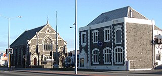
Sydenham is an inner suburb of Christchurch, New Zealand, two kilometres south of the city centre, on and around the city's main street, Colombo Street. It is a residential, retail and light industrial suburb.

<span class="mw-page-title-main">Seatoun</span> Suburb of Wellington City, New Zealand

Seatoun, an eastern suburb of Wellington, the capital city of New Zealand, lies on the east coast of the Miramar Peninsula, close to the entrance to Wellington Harbour, some seven kilometres southeast of the CBD. The suburb sits on an exposed promontory close to Barrett Reef, a dangerous area of rocky shallows upon which many ships have foundered, most notably the inter-island ferry TEV Wahine in 1968.

<span class="mw-page-title-main">Matauri Bay</span> Locality in Far North District, Northland Region, New Zealand

Matauri Bay is a bay in New Zealand, situated 30 km north of Kerikeri, in Whangaroa county, just north of the Bay of Islands. It has over a kilometre of white sand and crystal clear water, making it a popular summer destinations for surfers, divers, fishers and holidaymakers.

<span class="mw-page-title-main">Spreydon</span> Suburb of Christchurch, New Zealand

Spreydon is a suburb of Christchurch, New Zealand, 4 kilometres (2.5 mi) south-south-west of Cathedral Square. The most central street through Spreydon is Barrington Street. Spreydon is flanked by the suburbs Hoon Hay, Sydenham, and Lower Cashmere. State Highway 76 marks the northern boundary of the suburb, including the eastern end of the Christchurch Southern Motorway.

<span class="mw-page-title-main">Somerfield, New Zealand</span> Suburb of Christchurch, New Zealand

Somerfield is a suburb in the south of Christchurch, New Zealand. It is nominally bordered by the Ōpāwaho / Heathcote River to the south and west, Strickland and Colombo Streets to the east, and Milton Street to the north. The suburb includes Somerfield School, Somerfield Park and a small number of shops which service the local area, although it is predominantly residential. Somerfield is also known for its wide variety of trees, especially along the banks of the Ōpāwaho / Heathcote River.

<span class="mw-page-title-main">Burwood, New Zealand</span> Suburb of Christchurch, New Zealand

Burwood is a north-eastern suburb of Christchurch, New Zealand. The suburb is mostly a residential area and is centred on Burwood Hospital, Travis Wetland Nature Heritage Park and Bottle Lake Forest.

<span class="mw-page-title-main">Tikipunga</span> Suburb in Whangārei, New Zealand

Tikipunga is one of the biggest suburbs in Whangārei, New Zealand. It is in the north-east part of the city and has the landmark Whangārei Falls nearby.

<span class="mw-page-title-main">Redcliffs</span> Suburb of Christchurch, New Zealand

Redcliffs is an outer coastal suburb of Christchurch, Canterbury, New Zealand.

<span class="mw-page-title-main">Fairfield, Otago</span> Suburb in Dunedin, New Zealand

Fairfield is a suburb of Dunedin, New Zealand.

Onekawa is a suburb of the city of Napier, in the Hawke's Bay Region of the eastern North Island of New Zealand. Development of the suburb began in the late 1940s, after the land was acquired from then-Harbour Board.

Windsor Park is a small suburb located on the North Shore of Auckland, which is in New Zealand.

<span class="mw-page-title-main">Deanwell</span> Suburb of Hamilton, New Zealand

Deanwell is a suburb in south-western Hamilton in New Zealand. It is named after Deanwell Properties, the developers who subdivided the area. It was defined as a suburb of Hamilton in 1974.

<span class="mw-page-title-main">Clendon Park</span> Suburb in Auckland, New Zealand

Clendon Park is a suburb of Auckland in northern New Zealand. It is located to the west of Manurewa and north of Weymouth. The suburb is in the Manurewa-Papakura ward, one of the 21 local boards of Auckland Council.

<span class="mw-page-title-main">Welcome Bay</span> Suburb of Tauranga, New Zealand

Welcome Bay is a suburb of Tauranga, New Zealand. It is located 7 kilometres (4.3 mi) from central Tauranga. Neighbouring suburbs include Hairini and Maungatapu. There are a number of schools in Welcome Bay, including three primary schools.

Mangakakahi is a suburb of Rotorua in the Bay of Plenty Region of New Zealand's North Island.

<span class="mw-page-title-main">Masterton East</span> Suburb of Masterton, New Zealand

Masterton East is a suburb of Masterton, a town on New Zealand's North Island.

<span class="mw-page-title-main">Rānui</span> Suburb in Auckland, New Zealand

Rānui is a suburb of West Auckland, New Zealand, which is under the local governance of Auckland Council. The area is densely populated but close to the western fringe of the Auckland urban area.

Newfield is a suburb in the New Zealand city of Invercargill.

References

Commons-logo.svg Media related to Waltham, New Zealand at Wikimedia Commons

  1. 1 2 3 "ArcGIS Web Application". statsnz.maps.arcgis.com. Retrieved 1 October 2021.
  2. 1 2 "Population estimate tables - NZ.Stat". Statistics New Zealand . Retrieved 25 October 2023.
  3. "Christchurch City Council Environmental Newsletter" . Retrieved 20 April 2017.
  4. "Name of Suburb" (PDF). Retrieved 17 April 2017.
  5. 1 2 "Waltham: Christchurch's forgotten suburb". Stuff. 3 June 2016. Retrieved 19 October 2021.
  6. 2018 Census place summary: Waltham
  7. 2018 Census place summary: Charleston (Christchurch City)
  8. 2018 Census place summary: Lancaster Park
  9. 1 2 "Statistical area 1 dataset for 2018 Census". Statistics New Zealand. March 2020. Waltham (329900) and Charleston (Christchurch City) (329600).
  10. 1 2 "Statistical area 1 dataset for 2018 Census". Statistics New Zealand. March 2020. Lancaster Park (328800). 2018 Census place summary: Lancaster Park
  11. Education Counts: Waltham School
  12. Matthews, Philip (3 June 2016). "Waltham: Christchurch's forgotten suburb". The Press.
  13. Education Counts: Te Kura Kaupapa Māori o Waitaha
  14. "Te Hītori" (in Māori). Te Kura Kaupapa Māori o Waitaha. Retrieved 1 October 2021.
  15. "New Zealand Schools Directory". New Zealand Ministry of Education. Retrieved 14 March 2024.
  16. "Big crowd queues for Waltham Pool reopening". Stuff. 18 January 2015. Retrieved 19 October 2021.
  17. "Waltham Summer Pool". Christchurch City Council. Retrieved 19 October 2021.